District Disaster Management Plan District Kech, Balochistan - NDMA
District Disaster Management Plan District Kech, Balochistan - NDMA
District Disaster Management Plan District Kech, Balochistan - NDMA

You also want an ePaper? Increase the reach of your titles
YUMPU automatically turns print PDFs into web optimized ePapers that Google loves.
<strong>Disaster</strong> Risks in <strong>Kech</strong> <strong>District</strong><br />
2.1 Hazard, Capacity and Vulnerability<br />
The two major natural disasters of the recent past, and also the human induced catastrophes have<br />
brought about heavy losses to human population, their private property and overall infrastructure of the<br />
district. The data collection and hazard mapping exercises conducted by government departments, non<br />
government organizations (NGOs) and other stakeholders identified the following hazards and scenarios<br />
the most likely to affect the people of <strong>Kech</strong> that would require a sound response from the government.<br />
? High Priority_______________Flash flood and heavy rainfall<br />
? Medium Priority____________Infectious diseases and epidemic<br />
? Low Priority_______________Earthquake, Drought<br />
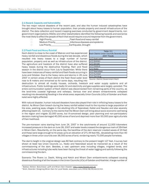
2.2 Flash Flood and Heavy Rainfall<br />
<strong>Kech</strong> district is close to the coast of Makran and has experienced<br />
heavy rainfall and disastrous floods during the last decade, which<br />
resulted into heavy losses to a large number of human<br />
population, property and as well as infrastructure of the district.<br />
The agriculture and livestock of the district have also suffered<br />
heavy losses during the destructive flooding. Rain and flood<br />
season in the district occur from July to September. While there<br />
have been instances of heavy rainfall and flash floods occurring in<br />
June and October. Due to the heavy rains and storms in 26 June<br />
2007 in certain areas of <strong>Kech</strong> district the flash flood water level<br />
rose to 8 meters and remained so for some days, resulting into<br />
destruction to almost all muddy houses, orchards, livestock and water supply systems and all<br />
infrastructure. Public buildings were badly hit and electricity and gas supplies were largely uprooted. The<br />
entire communication system of <strong>Kech</strong> district was disconnected from remaining parts of the country, as<br />
the land-links (coastal highways and railways). Various river and stream embankments collapsed<br />
resulting into devastating flooding in the whole area; especially Union Councils (UCs) of Gokdan and Kosh<br />
kalat were highly affected.<br />
With natural disaster, human induced disasters have also played their role in inflicting heavy losses to the<br />
district. As Mirani Dam breach during the heavy rainfall added insult to the injuries to large population of<br />
the area, washing away villages in the abutting UCs of Nasirabad, Kallat and Naudoz and also severely<br />
affecting Dasht UC. Contrary to the claims that the Mirani Dam will bring about socio-economic well being<br />
in the region and irrigate 32,000 acres, but ill-conceived design, poor planning and non-participatory<br />
decision-making have damaged 40,000 acres of land and deprived more than 50,000 poor agriculturists<br />
of their livelihood.<br />
The pre-monsoon rains starting from June 24, 2007 in the catchments of around 12,000 kilometers<br />
increased pressure in the dam on June 28, 2007 and water levels crossed the dangerous mark of 264 feet<br />
in Mirani Dam. Resultantly, on the same day, the backflow of the dam reservoir created waves of 20 feet<br />
and these were large enough to hit areas up to an elevation of 271.44 feet ASL, devastating more than 40<br />
villages in three union councils over 36,000 acres of land, rendering nearly 70,000 people homeless.<br />
The dam's height in the original design was 80 feet contrary to the present height 127 feet. A survey had<br />
shown at least two Union Councils i.e., Nodiz and Nasirabad would be marooned as a result of the<br />
commissioning of the dam. Besides, a vast upstream area including villages, irrigated lands, and<br />
infrastructures including tube wells have been facing the threat of water logging and salinity following the<br />
commissioning the dam.<br />
Scenario: The Rivers i.e. Dasht, Nihing and Ketch and Mirani Dam embankments collapsed causing<br />
disastrous flooding of all the houses in the Union Councils (UCs) of Gokdan and Koshilat. A large number of<br />
3 Babbar, Mohsin: <strong>Balochistan</strong> uplift and Mirani Dam <strong>Disaster</strong>: http://www.thepost.com.pk<br />
4 Brohi, Sikander: Designing Mirani Dam for Local Needs, www.dawn.com/2004/08/09/ebr12.htm<br />
6