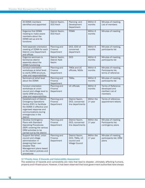
<strong>Disaster</strong> Risk <strong>Management</strong> <strong>Plan</strong> for the <strong>District</strong> 3.7 Priority Area: 2 Hazards and Vulnerability Assessment The existence of hazards and vulnerability are risks that lead to disaster, ultimately affecting humans, property and infrastructure. However, it has been observed that local government authorities have always 12
<strong>Disaster</strong> Risk <strong>Management</strong> <strong>Plan</strong> for the <strong>District</strong> focused on post-disaster developments rather than dealing with pre-disaster hazards and vulnerability in their respective areas. However, there is also dearth of hazards risk facts; specific to vulnerable areas at all levels i.e. tehsils, union council, and village. Hazard capacity vulnerability assessment (HCVA) is required to be carried out at Village, union council, tehsil and district levels. In this regard, a strong and participatory mechanism and system should be developed for gathering all information and facts for effective monitoring of hazards, vulnerabilities and risks. The locations of hazard-prone villages, union councils, tehsils and also key settlements in these areas should be identified on maps and analysed for vulnerability of settlements, housing, stock, important infrastructure and environmental resources. The analysis should focus the houses in hazard-prone areas, and the potential of losses to many housing categories. The vulnerability analysis should also identify key infrastructure and environmental resources in each local area that are prone to damage and loss from prevalent hazards. Vulnerabilities of various social groups in hazard prone areas should also be analyzed. Technical expertises could be requested from specialized government agencies such as NESPAK, Pakistan Meteorological Department, Flood Forecasting Centre, WAPDA, etc. to ensure scientific analysis of the geology and past history of hazards. They would also review secondary data from the 1998 census and other sources. Consultations with selected communities and stakeholders would be conducted to assess hazard exposure, disaster impact and vulnerabilities. The HCVA would keep abreast of Damages, Needs, Capacity Assessment (DNCA) during disasters. A central database should be developed and located at the <strong>District</strong> Emergency Operations Center (DEOC). 3.7.1 Lead Agency The district revenue department would be the leading agency for this action and would map out comprehensive assessment methodologies identify the means and as well as ensure that correct baseline data is available in order to facilitate a timely and efficient assessment of emergency situations. Hazard capacity vulnerability assessment (HCVA) of villages should also be undertaken. However, the revenue department would have the leading role in shaping out the methodology to be used. Consultation with NGOs and other relevant agencies is also proposed. 3.7.2 Key Activities to be undertaken within 6 Months Analysis and verification of available data through consulting various organisations Identify and select HCVA facilitators from the district personnel Map out HCVA tools and assessment methodologies and procedures Identify and select HCVA facilitators from tehsil, union councils and villages as well as from NGOs /CBOs Hold 1st facilitator's training of HCVA facilitators Identify HCVA of villages and union councils included in high priority hazard zones specifically generating hazard specific maps indicating the location of various hazards with zonation of risk levels; e.g. low, moderate and severe Collation of HCVAs Develop damage needs, capacity assessment forms Establish database of district 3.7.3 Activities to be accomplished within the First Year Update, contextualize and standardize assessment formats Identify HCVA facilitators other from tehsils, union councils, villages and NGOs/CBOs nd Conduct 2 facilitator's Training of HCVA facilitators 13