Minnetonka Boulevard - City of St. Louis Park
Minnetonka Boulevard - City of St. Louis Park
Minnetonka Boulevard - City of St. Louis Park

Create successful ePaper yourself
Turn your PDF publications into a flip-book with our unique Google optimized e-Paper software.
60 yds<br />
60 yds<br />
<strong>Minnetonka</strong> <strong>Boulevard</strong> &<br />
I-494<br />
Share | Print<br />
30 yds<br />
30 yds<br />
<strong>Minnetonka</strong> <strong>Boulevard</strong> &<br />
Baker Road<br />
60 yds<br />
60 yds<br />
<strong>Minnetonka</strong> <strong>Boulevard</strong> &<br />
Plymouth Road<br />
<strong>Minnetonka</strong> <strong>Boulevard</strong> &<br />
Shady Oak Road<br />
50 yds<br />
50 yds<br />
60 yds<br />
60 yds<br />
<strong>Minnetonka</strong> <strong>Boulevard</strong> &<br />
Co. Road 73<br />
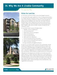
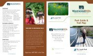
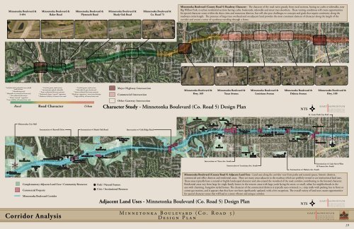
<strong>Minnetonka</strong> <strong>Boulevard</strong> (County Road 5) Roadway Character - The character <strong>of</strong> the road varies greatly, from rural sections, having no curbs or sidewalks, near<br />
Big Willow <strong>Park</strong>, to urban residential sections having curbs, boulevards, sidewalks and street trees elsewhere. These varying conditions will create opportunities<br />
for special character zones within the three cities and numerous districts, but will also pose challenges to concepts and goals that require continuity along the<br />
roadways entire length. The presence <strong>of</strong> large trees overhead and on adjacent land provides the most consistent element <strong>of</strong> character along the length <strong>of</strong> the<br />
corridor and creates a sense <strong>of</strong> a parkway traveling through a forest.<br />
50 yds<br />
50 yds<br />
50 yds<br />
50 yds<br />
50 yds<br />
50 yds<br />
50 yds<br />
50 yds<br />
50 yds<br />
* Includes both curbed & non-curbed<br />
road sections<br />
* Meandering trails<br />
* Sidewalks at commercial areas only<br />
* No residential driveways<br />
* Dense “natural” vegetation<br />
* Low visibility <strong>of</strong> homes from road<br />
Rural<br />
* Curb & gutter road section<br />
* Intermittent asphalt sidewalks<br />
* Some residential driveways present<br />
* Moderately dense “natural” vegetation<br />
* Moderate visibility <strong>of</strong> homes from road<br />
Road Character<br />
* Curb & gutter road section<br />
* Sidewalks & grass boulevards<br />
* Some residential driveways present<br />
* Moderate vegetation / street tree plantings<br />
* High visibility <strong>of</strong> homes from road<br />
Urban<br />
Major Highway Intersection<br />
Commercial Intersection<br />
Other Gateway Intersection<br />
<strong>Minnetonka</strong> <strong>Boulevard</strong> &<br />
Hwy. 169<br />
<strong>Minnetonka</strong> <strong>Boulevard</strong> &<br />
Texas Avenue<br />
Character <strong>St</strong>udy - <strong>Minnetonka</strong> <strong>Boulevard</strong> (Co. Road 5) Design Plan<br />
<strong>Minnetonka</strong> <strong>Boulevard</strong> &<br />
<strong>Louis</strong>iana Avenue<br />
<strong>Minnetonka</strong> <strong>Boulevard</strong> &<br />
Dakota Avenue<br />
NTS<br />
<strong>Minnetonka</strong> <strong>Boulevard</strong> &<br />
Hwy. 100<br />
*<br />
* <strong>Minnetonka</strong><br />
Christian Academy<br />
<strong>Minnetonka</strong> <strong>City</strong> Hall<br />
Civic Center * <strong>Park</strong><br />
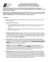
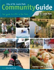
Complementary Adjacent Land Uses / Community Resources<br />
Commercial Property<br />
Intersection w/ Burwell Drive<br />
Minnehaha Creek<br />
<strong>Minnetonka</strong> <strong>Boulevard</strong> Corridor<br />
<strong>St</strong>. David’s School<br />
Burwell House<br />
<strong>Minnetonka</strong> Mills <strong>Park</strong><br />
* * *<br />
*<strong>Minnetonka</strong> Mills<br />
Commercial District<br />
Sunrise Ridge<br />
<strong>Minnetonka</strong><br />
<strong>Park</strong><br />
*<br />
Community Church<br />
*<br />
Intersection w/ Shady Oak Road<br />
Mills Landing * <strong>Park</strong><br />
Big Willow * <strong>Park</strong><br />
Guilliam * Fields<br />
Lake <strong>Minnetonka</strong> Regional Trail<br />
<strong>City</strong> <strong>of</strong> <strong>Minnetonka</strong><br />
Public Works<br />
*<br />
<strong>Park</strong> / Natural Feature<br />
*<br />
Civic / Institutional Resource<br />
*<br />
Intersection w/ Oak Ridge Road<br />
Minnehaha<br />
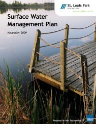
Adjacent Land Uses - <strong>Minnetonka</strong> <strong>Boulevard</strong> (Co. Road 5) Design Plan<br />
Creek<br />
Hannan * Lake<br />
Cobble * Crest<br />
Lake<br />
Westling * Pond<br />
North Cedar Lake Regional Trail<br />
Victoria * Lake<br />
Aquila<br />
Primary Center<br />
*<br />
Aquila * <strong>Park</strong><br />
Texa-Tonka *<br />
<strong>Park</strong><br />
Intersection w/ Texas Ave. South<br />
Rainbow <strong>Park</strong><br />
*<br />
*<br />
Trinity Lutheran<br />
Church<br />
Oak Hill <strong>Park</strong><br />
<strong>Louis</strong>iana<br />
* *<br />
Oaks <strong>Park</strong><br />
Intersection w/ <strong>Louis</strong>iana Ave. South<br />
Intersection w/ Dakota Ave. South<br />
NTS<br />
<strong>St</strong>. <strong>Louis</strong> <strong>Park</strong> <strong>City</strong> Hall<br />
Carpenter *<br />
<strong>Park</strong><br />
Intersection w/ Lake <strong>St</strong>reet West<br />
& Vernon Ave. South<br />
<strong>Minnetonka</strong> <strong>Boulevard</strong> (County Road 5) Adjacent Land Uses - Land uses along the corridor vary from parks and natural spaces, historic districts,<br />
commercial and <strong>of</strong>fice districts and residential areas. There are many areas adjacent to the roadway which are publicly owned or are institutional land uses.<br />
These areas typically have a natural or highly landscaped character and also extend the viewshed <strong>of</strong> the road corridor, contributing to the forested character.<br />
Residential areas vary from large lot single family homes in the western areas-with large yards facing the street, to small, urban lot neighborhoods in the<br />
east-with charming, bungalow styled homes. The character <strong>of</strong> the commercial districts is typically auto-oriented, i.e.: strip malls with parking lots in front or<br />
corner gas stations, and it appears that they have not been significantly updated, with a few exceptions. The overall variety <strong>of</strong> land uses creates opportunities<br />
for special character zones that will lead to a more vibrant and unique corridor.<br />
Bronx <strong>Park</strong><br />
*<br />
<strong>St</strong>. <strong>Louis</strong> <strong>Park</strong> * *Lennox Center<br />
Evangelical Free Church<br />
Good News For Isreal<br />
*<br />
<strong>St</strong>. <strong>Louis</strong> <strong>Park</strong> *<br />
Senior High School<br />
First Lutheran*<br />
Church<br />
Keystone <strong>Park</strong><br />
Roxbury * <strong>Park</strong>*<br />
Sunshine <strong>Park</strong><br />
*<br />
* Groves Academy<br />
Corridor Analysis<br />
M i n n e t o n k a B o u l e v a r d ( C o . R o a d 5 )<br />
D e s i g n P l a n<br />
October, 2008 19