Minnetonka Boulevard - City of St. Louis Park
Minnetonka Boulevard - City of St. Louis Park
Minnetonka Boulevard - City of St. Louis Park

You also want an ePaper? Increase the reach of your titles
YUMPU automatically turns print PDFs into web optimized ePapers that Google loves.
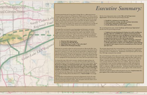
Executive Summary:<br />
The <strong>Minnetonka</strong> <strong>Boulevard</strong> (County Road 5) Design Plan is a collaboration between<br />
Hennepin County and the cities <strong>of</strong> <strong>Minnetonka</strong>, Hopkins and <strong>St</strong>. <strong>Louis</strong> <strong>Park</strong> to conceive<br />
a travel corridor that addresses the needs <strong>of</strong> a variety <strong>of</strong> commuting, recreational and local<br />
travelers. The Design Plan seeks to capitalize on the opportunities <strong>of</strong>fered by the natural<br />
setting, cultural resources and location between major lakes and adjacent regional trails.<br />
The extent <strong>of</strong> this study, from Interstate 494 on the west to a point just east <strong>of</strong> <strong>St</strong>ate<br />
Highway 100 on the east, includes a key segment <strong>of</strong> the road that links two city halls and<br />
establishes a core from which the design concepts that are developed could be further<br />
extended east and west.<br />
The Design Plan was initiated by researching background information and analysis<br />
about the current environment <strong>of</strong> <strong>Minnetonka</strong> Blvd., and by developing a number<br />
<strong>of</strong> opportunities for potential improvements that could be made along the corridor.<br />
Public comments were sought on the subjects <strong>of</strong> how the road functions, its appearance<br />
and how local citizens were using it. They were also asked to identify which potential<br />
improvements they would give the highest (or lowest) priority to. The top four priorities<br />
for improvements that were mentioned by the public were:<br />
1. Pedestrian Safety Improvements<br />
2. Continuous East-West Bike Route<br />
3. Multi-Modal Scenic Corridor (“Link to the Lakes”)<br />
4. Additional Tree Planting/Landscaping<br />
While there are currently no plans for road reconstruction on <strong>Minnetonka</strong> Blvd., there<br />
are numerous other projects that are moving forward on properties and roadways that lie<br />
adjacent to or intersect it. As a result, there may be opportunities to implement the plan<br />
over time as these related projects go forward, and as the various cities and County find<br />
additional fiscal resources. To this end, the design plan is intended to identify important<br />
functions <strong>of</strong> the <strong>Boulevard</strong> and how they could best be improved. This information will<br />
serve as a springboard for future planning by the County and Cities sponsoring the study.<br />
It is beyond the scope <strong>of</strong> this study to propose a detailed and engineered layout for<br />
the entire length <strong>of</strong> the study area, or to resolve all <strong>of</strong> the potential conflicts between<br />
stakeholders, property owners and agencies who have an interest in the roadway. Rather,<br />
the intent is to develop a set <strong>of</strong> general principles and a range <strong>of</strong> ideas that would<br />
address the goal <strong>of</strong> the County and Cities to describe a street that considers multiple<br />
modes <strong>of</strong> transportation and various reasons for traveling on it, from commuting, to<br />
recreation, to local shopping. Based on a positive response received at the two public<br />
meetings, an overall theme <strong>of</strong> “Link to the Lakes” should be considered, which ultimately<br />
could extend from Lake <strong>Minnetonka</strong> to the Minneapolis Grand Rounds. In addition,<br />
the overall idea <strong>of</strong> making <strong>Minnetonka</strong> <strong>Boulevard</strong> as a “Scenic Corridor” was strongly<br />
endorsed.<br />
The Design Plan recommendations are presented in diagrammatic form for the entire<br />
study area and on several prototype plans that describe the recommendations at some<br />
<strong>of</strong> the key intersections along the corridor. Some assumptions about the relative cost <strong>of</strong><br />
various proposed improvements are also included.<br />
The first <strong>of</strong> two diagrammatic plans, entitled “Bike and Trail Improvement<br />
Opportunities”, describes these four general design principles:<br />
1. Provide for a continuous on-street bike route<br />
2. Enhance pedestrian crossings, especially at primary intersections<br />
3. Create better connections to regional trails<br />
4. Provide additional bike and transit support facilities<br />
The second diagrammatic plan, entitled “Landscape and <strong>St</strong>reetscape Opportunities”,<br />
describes these five general design principles:<br />
1. Emphasize the natural landscape by framing views and by installing new<br />
plantings within the road ROW and on adjacent institutional properties<br />
2. Use formal arrangements <strong>of</strong> trees and lighting in commercial areas only<br />
3. Use landscape as the main unifier along the corridor; allow other features<br />
to change between districts to reflect their unique identities<br />
4. Develop a hierarchy <strong>of</strong> gateways, at highway interchanges, commercial<br />
districts and at pedestrian crossings, to reinforce regional & <strong>City</strong> identity<br />
5. Identify opportunities to improve views <strong>of</strong> Minnehaha Creek by thinning<br />
out vegetation and to improve access for recreational users <strong>of</strong> the Creek and<br />
open space areas.<br />
The prototype plans describe these recommendations in more detail at major intersections<br />
such as Plymouth Rd and Texas Ave.; at the Hwy 169 interchange and at neighborhood<br />
intersections such as at Hampshire Ave. Additionally, several important goals for a future<br />
Hwy 100 bridge crossing have been included.<br />
Due to the limited scope <strong>of</strong> this study, several “areas <strong>of</strong> further study” have been identified<br />
that will require additional master planning thought, engineering effort, public input or<br />
agency review before the final form <strong>of</strong> ideas suggested in this report can be verified. For<br />
example, a major goal <strong>of</strong> the Design Plan is to encourage a continuous on-street bike<br />
route, consistent with both city policy and county standards. There may be obstacles<br />
to achieving this in some areas due to grading constraints or ROW width limitations.<br />
Potential solutions are suggested in this study, including the purchasing <strong>of</strong> additional<br />
ROW or a reduction in traffic lane dimensions. Ultimately, the preferred solution will be<br />
determined at the time <strong>of</strong> implementation for a given segment <strong>of</strong> the corridor, based on<br />
local factors and interests.<br />
Ultimately, the preferred solution will be determined at the time <strong>of</strong> implementation for a<br />
given segment <strong>of</strong> the corridor, based on local factors and interests.