Minnetonka Boulevard - City of St. Louis Park
Minnetonka Boulevard - City of St. Louis Park
Minnetonka Boulevard - City of St. Louis Park

You also want an ePaper? Increase the reach of your titles
YUMPU automatically turns print PDFs into web optimized ePapers that Google loves.
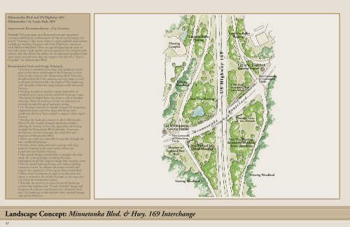
<strong>Minnetonka</strong> Blvd and US Highway 169 –<br />
<strong>Minnetonka</strong> / <strong>St</strong>. <strong>Louis</strong> <strong>Park</strong>, MN<br />
Improvement Recommendations - <strong>City</strong> Gateway:<br />
General: This prototype and illustrated concept represents<br />
recommendations for enhancement <strong>of</strong> one <strong>of</strong> several major city<br />
arrival “Gateways” that occur where a major regional road system,<br />
including Interstate Freeways and <strong>St</strong>ate Highways, intersects<br />
with <strong>Minnetonka</strong> Blvd. These are special opportunity areas to<br />
not only create a high quality arrival experience for residents and<br />
visitors, but also allows the ability for an enhanced woodland and<br />
open space environment that can support the idea <strong>of</strong> a “Scenic<br />
Corridor” for <strong>Minnetonka</strong> Blvd.<br />
Recommended Goals and Design Principals:<br />
• Develop a comprehensive, large scale landscape master<br />
plan for the entire intersection <strong>of</strong> the Interstate or <strong>St</strong>ate<br />
road corridor system with <strong>Minnetonka</strong> Blvd. This plan<br />
should include all <strong>of</strong> the entrance and exit ramps, as well<br />
as all land contained within the Right <strong>of</strong> Way beginning<br />
with the point where the ramps intersect with the actual<br />
Freeway.<br />
• Develop the plan to include a major restoration <strong>of</strong><br />
woodland and a more natural, informal landscape image.<br />
This should included dense tree areas as well as meadow<br />
clearings. Allow all roadways to have an experience <strong>of</strong><br />
moving through this great landscape setting.<br />
• Use the plant material to visually mitigate the pragmatic,<br />
engineered slopes and other slope and storm water<br />
conditions that have been created in support <strong>of</strong> the major<br />
freeway.<br />
• Develop the landscape concept to allow <strong>Minnetonka</strong><br />
Blvd to be the visually strongest landscape corridor,<br />
allowing the freeway to have the appearance <strong>of</strong> moving<br />
through the <strong>Minnetonka</strong> Blvd landscape. At present,<br />
the freeway corridor interrupts the visual flow and<br />
character <strong>of</strong> <strong>Minnetonka</strong> Blvd.<br />
• Allow new trails and sidewalks to meander through the<br />
new woodland landscape<br />
• Provide clearly delineated road crossings with large<br />
painted stripping on the road surface where cars,<br />
pedestrians and bicycles intersect.<br />
• Take special design consideration to mitigate the areas<br />
under the existing bridges including the slope<br />
embankments and the negative image that currently exists.<br />
• Provide special lighting fixtures and indirect lighting<br />
concepts on trees to enhance the scenic corridor and<br />
support the experience <strong>of</strong> driving on <strong>Minnetonka</strong> Blvd.<br />
• Allow entry monuments or signs to be placed at exit<br />
ramps to announce the arrival <strong>of</strong> people in the respective<br />
city where the intersection occurs.<br />
• Basically, the intent is to create an overall landscape<br />
context that reinforces the “Scenic Corridor” image and<br />
integrates the adjacent residential and community land<br />
uses. Use landscape to also provide color, seasonal change<br />
and spatial definition.<br />
Housing<br />
Complex<br />
Existing<br />
Woodland<br />
<strong>City</strong> <strong>of</strong> <strong>Minnetonka</strong><br />
Gateway Feature<br />
New Crosswalks<br />
w/ Countdown<br />
Clocks<br />
Meadow w/<br />
Scattered New<br />
Trees<br />
Land Use Buffer<br />
Planting<br />
Existing Woodland<br />
New Tree Planting<br />
M i n<br />
n e t o n<br />
New Wetland Edge<br />
Shrub Massings<br />
k a<br />
U S H i g h w a y 1 6 9<br />
( C o u n t y R o a d 5 )<br />
Land Use Buffer<br />
Planting<br />
<strong>City</strong> <strong>of</strong> <strong>St</strong>. <strong>Louis</strong> <strong>Park</strong><br />
Gateway Feature<br />
8’ Off-Road<br />
Meandering Trail<br />
Connection<br />
6’ Continuous Bike Route (Both<br />
B o u l e v a r d<br />
Sides)<br />
Maintain Views<br />
into Wetlands<br />
New Tree Planting -<br />
Re-establish Woodland<br />
Across Interchange<br />
New Crosswalks<br />
w/ Countdown<br />
Clocks<br />
Existing Woodland<br />
52<br />
Design Prototype: <strong>City</strong> Gaterway<br />
Hwy. 169 at <strong>Minnetonka</strong> <strong>Boulevard</strong><br />
Landscape Concept: <strong>Minnetonka</strong> Blvd. & Hwy. 169 Interchange