

CHANGE SERVICE REQUESTED The California Surveyor ... - CLSA
CHANGE SERVICE REQUESTED The California Surveyor ... - CLSA
CHANGE SERVICE REQUESTED The California Surveyor ... - CLSA

Create successful ePaper yourself
Turn your PDF publications into a flip-book with our unique Google optimized e-Paper software.
<strong>CHANGE</strong> <strong>SERVICE</strong> <strong>REQUESTED</strong><br />
<strong>The</strong> <strong>California</strong> <strong>Surveyor</strong><br />
P.O. Box 9098<br />
Santa Rosa, CA 95405-9990
<strong>CLSA</strong> Officers 2008<br />
James M. Herrick, President<br />
Matthew J. Vernon, President-Elect<br />
Aaron R. Smith, Secretary<br />
William R. Hofferber, Treasurer<br />
Steven C. Shambeck, Immediate Past President<br />
Dorothy Calegari, Executive Director<br />
Board of Directors • Chapter Representatives<br />
BAKERSFIELD CHAPTER<br />
Rolland VanDeValk<br />
CASCADE CHAPTER<br />
John M. Bettes • Frank Robert Lehmann<br />
CENTRAL COAST CHAPTER<br />
David Carey • Linda Richardson • Rochelle Vierra<br />
CENTRAL VALLEY CHAPTER<br />
Michael Jones • Keith W. Spencer<br />
CHANNEL ISLANDS CHAPTER<br />
Bruce D. Barton • Kurt J. Lehnhardt<br />
DESERT CHAPTER<br />
Levi D. Cox • Ron Moreno<br />
EAST BAY CHAPTER<br />
Harold Davis • Steven Martin • Thomas Taylor<br />
GOLD COUNTRY CHAPTER<br />
Marc R. Van Zuuk<br />
HUMBOLDT CHAPTER<br />
Michael D. Pulley<br />
LAKE/MENDOCINO CHAPTER<br />
Randy G. Haralson<br />
LOS ANGELES CHAPTER<br />
Aleck Cheney • Stephen Hughey • Raymundo Lombera<br />
MARIN CHAPTER<br />
Douglas J. Scranton<br />
MONTEREY BAY CHAPTER<br />
Christopher Bateman<br />
MOTHER LODE CHAPTER<br />
Russell F. Walter<br />
NORTHERN COUNTIES CHAPTER<br />
Roger Keith Hanlin<br />
ORANGE COUNTY CHAPTER<br />
Peter Fitzpatrick • David Hill • Kurt R. Troxell<br />
Jerry Uselton • David Woolley<br />
RIVERSIDE/SAN BERNARDINO CHAPTER<br />
James A. Drenon • Robert Vasquez<br />
SACRAMENTO CHAPTER<br />
Paul Carlson • Donald Lee Ivy • Evan Page<br />
SAN DIEGO CHAPTER<br />
David Ambler • Anne Hoppe • Andrew Karydes<br />
Marvin John Sylakowski • Donald Woolley<br />
SAN JOAQUIN VALLEY CHAPTER<br />
Ted Kerber<br />
SANTA CLARA/SAN MATEO CHAPTER<br />
Paul W. Lamoreaux, Jr. • Keith Nofield<br />
SONOMA COUNTY CHAPTER<br />
James M. Dickey • Michael Jones
Inside This Issue:<br />
Features:<br />
Women in Surveying<br />
Articles by:<br />
<strong>The</strong> quarterly publication of the <strong>California</strong> Land <strong>Surveyor</strong>s<br />
Association, Inc. and is published as a service to the land surveying profession<br />
of <strong>California</strong>. It is mailed to all Licensed Land <strong>Surveyor</strong>s in the<br />
State of <strong>California</strong> as well as to all members of the <strong>California</strong> Land<br />
<strong>Surveyor</strong>s Association, Inc. <strong>The</strong> <strong>California</strong> <strong>Surveyor</strong> is an open forum for<br />
all <strong>Surveyor</strong>s, with an editorial policy predicated on the preamble to the<br />
Articles of Incorporation of the <strong>California</strong> Land <strong>Surveyor</strong>s Association,<br />
Inc. and its stated aims and objectives, which read:<br />
“Recognizing that the true merit of a profession is determined by the<br />
value of its services to society, the <strong>California</strong> Land <strong>Surveyor</strong>s Association<br />
does hereby dedicate itself to the promotion and protection of the profession<br />
of land surveying as a social and economic influence vital to the welfare<br />
of society, community, and state.”<br />
“<strong>The</strong> purpose of this organization is to promote the common good<br />
and welfare of its members in their activities in the profession of land surveying,<br />
to promote and maintain the highest possible standards of professional<br />
ethics and practices, to promote professional uniformity, to promote<br />
public faith and dependence in Land <strong>Surveyor</strong>s and their work.”<br />
Fall 2008<br />
PERSONNEL<br />
OWNER<br />
<strong>California</strong> Land <strong>Surveyor</strong>s Association, Inc.<br />
CENTRAL OFFICE<br />
526 So. E Street<br />
Santa Rosa, CA 95404<br />
E-Mail address: clsa@californiasurveyors.org<br />
<strong>CLSA</strong> Homepage: www.californiasurveyors.org<br />
EDITOR<br />
John P. Wilusz, PLS, PE<br />
ASSISTANT EDITOR<br />
Dave Ryan, PLS<br />
DESIGN AND PRODUCTION<br />
Tony Monaco<br />
ADVERTISING<br />
Commercial advertising is accepted by <strong>The</strong> <strong>California</strong> <strong>Surveyor</strong>.<br />
Advertising rates and information can be obtained by contacting <strong>CLSA</strong><br />
Central Office, P.O. Box 9098, Santa Rosa, CA 95405, (707) 578-6016,<br />
Fax (707) 578-4406. Circulation: 4,800.<br />
EDITORIAL MATERIAL<br />
All articles reports, letters, and contributions are accepted and will<br />
be considered for publication regardless of the author’s affiliation with the<br />
<strong>California</strong> Land <strong>Surveyor</strong>s Association, Inc. Contributions should be<br />
emailed to clsa@californiasurveyors.org. We can accept WordPerfect or<br />
Microsoft Word files. We can accept ASCII text files or word processor<br />
files from the following programs: WordPerfect or Microsoft Word.<br />
EDITOR’S ADDRESS<br />
John P. Wilusz, PLS, PE<br />
5512 Cedar Creek Way<br />
Citrus Heights, CA 95610<br />
E-mail: johnwilusz@gmail.com<br />
DEADLINE DATES<br />
Spring . . . . . . . .February 10 Summer . . . . . . .May 10<br />
Fall . . . . . . . . .August 10 Winter . . . . . . . .November 10<br />
Articles, reports, letters, etc., received after the above mentioned<br />
date will be considered for the next edition.<br />
Opinions expressed by the editor or individual writers are not necessarily<br />
endorsed by the <strong>California</strong> Land <strong>Surveyor</strong>s Association Officers or<br />
its Board of Directors. Original articles may be reprinted with due credit<br />
given to the source and written notification to the <strong>California</strong> Land<br />
<strong>Surveyor</strong>s Association, unless otherwise noted.<br />
Marta Alvarez, PE, PLS . . . . . . . . . . . . . . . . . . . . . . . . . . . . . . . . .14<br />
Lorraine Amenda, PLS . . . . . . . . . . . . . . . . . . . . . . . . . . . . . . . . . .16<br />
Gwen Gee, PLS . . . . . . . . . . . . . . . . . . . . . . . . . . . . . . . . . . . . . . .18<br />
Anne Hoppe, PLS . . . . . . . . . . . . . . . . . . . . . . . . . . . . . . . . . . . . . .20<br />
Carol Knox, PLS . . . . . . . . . . . . . . . . . . . . . . . . . . . . . . . . . . . . . . .24<br />
Linda Richardson, PLS . . . . . . . . . . . . . . . . . . . . . . . . . . . . . . . . . .28<br />
Susan Ruschmeyer, PLS . . . . . . . . . . . . . . . . . . . . . . . . . . . . . . . .38<br />
Toni Scoralle, PLS . . . . . . . . . . . . . . . . . . . . . . . . . . . . . . . . . . . . . .42<br />
Cecilia Whitaker, PLS . . . . . . . . . . . . . . . . . . . . . . . . . . . . . . . . . . .46<br />
Girl Scouts and the Basic Land Surveying<br />
Badge:<br />
By: Delia Smith, PLS . . . . . . . . . . . . . . . . . . . . . . . . . . . . . . . . . . . .12<br />
TECH TIPS:<br />
Controlling a Photogrammetric Model from the Sky<br />
By: Jas Arnold, PLS . . . . . . . . . . . . . . . . . . . . . . . . . . . . . . . . . . . .30<br />
Web Wanderings:<br />
Virtualization, Cloud Computing and Open Source<br />
By: Levi Cox, PLS . . . . . . . . . . . . . . . . . . . . . . . . . . . . . . . . . . . . . .34<br />
<strong>Surveyor</strong>’s Limits of Liability<br />
By: Ralph Simoni, Esq, <strong>CLSA</strong> Legislative Advocate . . . . . . . . . . . .36<br />
Risk Management for Land <strong>Surveyor</strong>s<br />
By: Richard Hertzberg, CPCU, ARM, Vista International . . . . . . . .48<br />
Department:<br />
From the Editor & Guest Editor . . . . . . . . . . . . . . . . . . . . .6/7<br />
Letter to the Editor . . . . . . . . . . . . . . . . . . . . . . . . . . . . . . .7<br />
Presidents Message . . . . . . . . . . . . . . . . . . . . . . . . . . . . . .10<br />
Kids Korner . . . . . . . . . . . . . . . . . . . . . . . . . . . . . . . . . . . . .8<br />
Index of Advertisers . . . . . . . . . . . . . . . . . . . . . . . . . . . . . .39<br />
Welcome New Members . . . . . . . . . . . . . . . . . . . . . . . . . . .41<br />
Crossword Puzzle . . . . . . . . . . . . . . . . . . . . . . . . . . . . . . .44<br />
Photo of the Year Submissions . . . . . . . . . . . . . . . . . . . . . .50<br />
Publication Order Form . . . . . . . . . . . . . . . . . . . . . . . . . . .51<br />
Sustaining Members . . . . . . . . . . . . . . . . . . . . . . . . . . . . .52<br />
Membership Application . . . . . . . . . . . . . . . . . . . . . . . . . . .54<br />
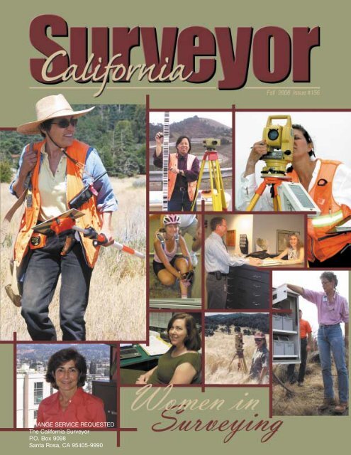
Cover Photo:<br />
Women in Surveying<br />
5
In August I had the opportunity to<br />
attend my first Environmental<br />
Systems Research Institute (ESRI) User Conference. What a trip! I<br />
knew GIS was huge but it’s even bigger than I thought. One quarter<br />
of a million organizations across the world use ArcGIS in a vast<br />
and diverse array of applications such as: planning, utility distribution,<br />
water resources, transportation, civil and environmental<br />
engineering, flood management, land surveying, mapping, natural<br />
resources management, human resources management, defense,<br />
archaeology, emergency services and public safety; in other<br />
words, anything and everything that pertains to the collection,<br />
analysis and use of spatial data. Forgive me if I left something out.<br />
<strong>The</strong> list appears to be endless.<br />
That GIS is diverse is reflected in the people who use it. <strong>The</strong><br />
first thing I noticed about conference attendees, besides there being<br />
so many of them, was that women and minorities were well-represented.<br />
<strong>The</strong> GIS crowd is young too, much younger than what we<br />
are accustomed to seeing at land surveyors’ gatherings. <strong>The</strong> opening<br />
ceremony and plenary session was hosted by the charismatic<br />
Jack Dangermond, founder and president of ESRI. According to<br />
Jack there were some 14,500 attendees from 121 countries, and to<br />
me it looked like they were all present to hear him speak. <strong>The</strong> shear<br />
size of the audience conveyed the message that GIS is changing the<br />
world, one click at a time.<br />
<strong>The</strong> plenary session also featured a number of speakers besides<br />
Jack. Each in their own way touched upon the conference’s theme<br />
“GIS: Geography in Action.” Of particular interest to surveyors was<br />
U.S. Department of the Interior Secretary Dirk Kempthorne, who<br />
announced that the full archive of USGS Landsat images will be<br />
available online and for free by February 2009. For more information<br />
on this welcome development go to: http://landsat.usgs.gov/<br />
images/squares/USGS_Landsat_Imagery_Release.pdf<br />
In some ways the most impressive plenary speaker, at least for<br />
me, was a 6th grade student. Molly Paterson of Flynn Park<br />
Elementary School, University City, Missouri, spoke with remarkable<br />
confidence and poise about a GIS demographics project she<br />
worked on at school. Turns out that smart kids like Molly are integral<br />
to Jack Dangermond’s vision for the future; ESRI is drawing<br />
the attention of youth to GIS by an ambitious outreach program.<br />
One example is the ESRI GIS program for 4-H. By various grants<br />
this program supports national 4-H efforts geared to bringing GIS<br />
6<br />
<strong>The</strong> 28 th Annual ESRI<br />
User Conference,<br />
August 4-8, 2008,<br />
San Diego, CA<br />
CORRECTION NOTICE: Correction to the Summer Issue #155<br />
Our apologies to Cecilia Whitaker, PLS, for errors inadvertently introduced<br />
into her article during layout of Issue #155. <strong>The</strong> correct version<br />
of “Using the Scripps Epoch Coordinate Tool On-line Resource<br />
(SECTOR) for Changing Between Epochs” is in the digital version of<br />
the magazine posted on the <strong>CLSA</strong> website at:<br />
http://www.californiasurveyors.org/files/calsurveyor/CalSurv155.pdf<br />
By: John P. Wilusz, PLS, PE - Editor<br />
From the Editor<br />
to young people. At the conference I met several 4-H clubs from<br />
across the country. One group from Oklahoma told me about volunteer<br />
work they did to locate and document fire hydrants for their<br />
city’s GIS. A teenager from upstate New York told me how she<br />
applied her GIS skills, with software donated by ESRI, to help preserve<br />
local endangered wildflowers. Another group from North<br />
Carolina used ESRI-donated software to create a map book for their<br />
county’s Economic Development Department. <strong>The</strong> book features<br />
exhibits pertaining to their county’s history, economy, geography,<br />
demographics and recreational opportunities. It was subsequently<br />
published and over 7,000 copies sold. ESRI outreach coordinators<br />
are also working on a GIS Scouting merit badge, which they anticipate<br />
being in place in 2009.<br />
Women in Surveying<br />
Fortunately for us land surveyors we have volunteers doing<br />
similar outreach work in our own professional community. Our<br />
theme this issue of the <strong>California</strong> <strong>Surveyor</strong> is “Women in<br />
Surveying.” Be sure to read Dee Smith’s inspiring article “Girl<br />
Scouts and the Basic Land Surveying Badge.” I bet you did not even<br />
know there was a surveying merit badge for the Girl Scouts. That’s<br />
because there wasn’t one until Dee and her colleagues took action.<br />
If there is a better example of surveyors promoting their profession<br />
I have not heard about it.<br />
Continuing our “Women in Surveying” theme we are featuring<br />
a series of articles written by female land surveyors. Our goal for<br />
this feature is twofold: First, we wish to highlight contributions<br />
women make to professional land surveying practice in <strong>California</strong>.<br />
Second, we hope to provide inspiration and encouragement to<br />
young women who might be attracted to a career in land surveying.<br />
We asked our contributing writers to tell us how they found their<br />
way into this profession and what it’s like to be a woman in a maledominated<br />
field. Taken together, their articles paint a colorful picture<br />
of what great diversity there is in professional land surveying<br />
practice in our state, regardless of gender. By their fine efforts we<br />
have an opportunity to learn about areas of professional expertise<br />
we might not otherwise be exposed to. Many thanks to my friend<br />
Annette Lockhart, our guest editor, for her instrumental role in<br />
bringing this feature to the magazine. Without her it would not have<br />
been possible.<br />
Speaking of service to the profession, I’m pleased to announce<br />
that our own “woman in surveying,” Dorothy Calegari, was by<br />
unanimous vote made an honorary member of the <strong>California</strong> Land<br />
<strong>Surveyor</strong>s Association at the July Board of Directors meeting in<br />
Oakland. Congratulations, Dorothy!<br />
And finally my thanks to all who make our magazine the<br />
award-winning publication that it is. As I’ve said before it takes<br />
many hands to make the <strong>California</strong> <strong>Surveyor</strong> and I feel fortunate to<br />
have mine among them. ❖<br />
John Wilusz, PLS, PE, is a Water Resources Engineer in the<br />
Delta-Suisun Marsh Office of the <strong>California</strong> Department of Water<br />
Resources.<br />
www.californiasurveyors.org
From the Guest Editor<br />
By: Annette Lockhart, PLS<br />
My grandfather, who was a retired mechanic from<br />
Operating Engineers Local 3, asked me at a family party<br />
one time if I was still hanging with those surveyors. Yep,<br />
Papa, I still am.<br />
I work for Caltrans. I started work as an Office Assistant for<br />
the Lab and Surveys in District 10 (Stockton). I did not even know<br />
that there were land surveyors until I came to work there! An<br />
opportunity presented itself to take the Junior Engineering<br />
Technician exam (a classification, I am sad to report, that Caltrans<br />
has chosen to eliminate). From that exam, I landed in a job on a<br />
Caltrans Surveys Field crew. I have worked with some excellent<br />
people over the years, each one helpful in their own way. Last year,<br />
I passed the PLS exam and I was never so happy to see an envelope<br />
in my whole life!<br />
Working at Caltrans is great! Surveying has many faces and<br />
you can try them all here. I have been on a field crew, in the office,<br />
in field support, in Right of Way Engineering (that is boundary<br />
surveying to the rest of the world), in the Office of<br />
Photogrammetry, the Office of Land Surveys and now, the Office<br />
of GIS. Each stop has afforded me one of the great opportunities<br />
that land surveying has to offer…learning. In this profession you<br />
only stop learning because you want to stop.<br />
I feel very fortunate to be involved with this issue of the<br />
<strong>California</strong> <strong>Surveyor</strong> that focuses on Women in Surveying. In my<br />
“normal” life, I prepare the Focal Point, a newsletter for the<br />
Sacramento chapter of <strong>CLSA</strong>. I have to tell you this job is a whole<br />
lot different. John deserves a great standing ovation for the outstanding<br />
job he does! It is really tough!<br />
As you read these articles I hope you will see what I saw…a<br />
little bit of yourself in each story. It was amazing to me how<br />
parts of each of their stories are actually a part of my own, as<br />
well. One writer was a Navy Seabee (I was a Navy Storekeeper).<br />
Another works with the American Association of University<br />
Fall 2008<br />
Women (I recently delivered a keynote address for one of their<br />
events.) All of the contributors found their way to the surveying<br />
profession by accident. (Me, too!) I think you will find their<br />
paths interesting and the work they highlighted fascinating!<br />
In addition, all the women talk in glowing terms about<br />
“the guys.” I have to say on this point I must agree. I have<br />
always found men and women in our profession to be encouraging<br />
and helpful. I realize somewhere there are things that<br />
happen that are not wonderful, but in this issue we have contributors<br />
from all kinds of backgrounds and they all seem to<br />
think that “the bad stuff ” must have happened somewhere<br />
else.<br />
I think you will also enjoy reading about the number of<br />
ways these women give back to the profession. I believe this<br />
to be very important as well. In Sacramento, I help facilitate<br />
the PLS exam preparation course for the Sacramento Chapter.<br />
As part of preparing folks for licensure, we stress the importance<br />
of giving back by taking an active part in the shaping of<br />
the profession.<br />
Well, you are just a turn of the page away from our efforts.<br />
I sincerely hope that you enjoy these articles as much as I did.<br />
Take an opportunity to share this issue with others who might be<br />
waiting for the “accident” that leads them to a fulfilling career in<br />
land surveying. ❖<br />
Letter to the Editor<br />
In the article “<strong>The</strong> <strong>Surveyor</strong> and<br />
the Speed of Light” published in the<br />
<strong>California</strong> <strong>Surveyor</strong> issue #155 the<br />
author has taken CORS station velocity<br />
data of a few years, expanded this data back in<br />
time ~80 years and insinuates the original surveyors made a<br />
measurement error. I personally would accept invar tape measurements<br />
over any GPS or EDM data produced today.<br />
Anyone with survey experience knows that expanding your<br />
survey beyond your original control is going to multiply the<br />
error by the distance expanded compared to the original distance.<br />
For example, a 100 foot control line with an error of 0.01ft<br />
expanded to 200 feet now has at least a 0.02ft error. Expand it 15<br />
times and do the math.<br />
This is the same unsubstantiated thinking that has some<br />
people in this Country making millions of dollars (Al Gore is<br />
one) off the “Man Made Global Warming (GW)” theory. And<br />
that’s exactly what it is, a theory. <strong>The</strong> computer programs they<br />
are claiming proves the GW theory by taking old weather data<br />
and predicting our weather 40 years from now cannot predict the<br />
weather of the 60’s or 70’s.<br />
Should we use 5 or 10 year old data, push it out 60 or 80 years<br />
and say that is more accurate than actual data created at that time?<br />
W. Tom Foster, P.L.S.<br />
7
Kids<br />
Korner<br />
Do you have a picture of the “junior surveyor” in your family that you<br />
would like to share? Send it in and we will put it in the Kids Korner.<br />
Ashley Allums spends kids day at work helping Dad (Spear &<br />
Associates Party Chief Bob Allums) establish a control traverse<br />
in a commercial development in San Marcos.<br />
Looks like she’s showing old Dad a few new tricks, like how to<br />
make a dirty old vest look good!<br />
Jacob Gambino, son of Peter Gambino, PE, PLS,<br />
appreciating the fine articles and historic photographs<br />
in Issue #150<br />
8<br />
www.californiasurveyors.org
By: James M. Herrick, PLS - President<br />
President’s Message<br />
It is moving towards autumn at seemingly breakneck speed.<br />
Time does fly when you are having fun! This year as your president<br />
is definitely moving along much faster than anticipated<br />
so here I am working on my third quarter message. Before I get to<br />
the main topic I have a couple of items that I want to point out to<br />
you. First of all I want you to know that we have completed the<br />
Salary Survey and the results are available on the <strong>CLSA</strong> website<br />
www.californiasurveyors.org. I want to thank all of you who participated<br />
in the survey. We tabulated nearly 1000 responses, which<br />
is a good sampling. We broke the survey into four geographic sections<br />
and each section was further broken down by job description.<br />
<strong>The</strong>re is a mountain of information in these survey results<br />
and I encourage you to review them. Also I want to be sure that<br />
everyone is aware that Patrick Tami was reappointed to the Board<br />
for Professional Engineers and Land <strong>Surveyor</strong>s by Governor<br />
Schwarzenegger. At the July 31, 2008 Board meeting Pat was<br />
elected President of the Board! Pat has also become the Vice<br />
President of the Western Zone of NCEES. This is probably old<br />
news by now but I want to recognize Pat for his efforts. We are fortunate<br />
to have someone like Pat who is willing to take on these<br />
extra duties and I applaud him for that. <strong>The</strong>re is an old saying that<br />
some of you might remember, “<strong>The</strong> cream always rises to the top”.<br />
In the case of Pat Tami this is definitely true!! Thank you Pat!<br />
<strong>The</strong> primary topic that I have chosen for this issue is the<br />
Voluntary Professional Development Program that <strong>CLSA</strong> has<br />
recently established. <strong>The</strong>re is a link to specific information,<br />
details, and the required application on the <strong>CLSA</strong> website. In a nut<br />
shell this program was designed to follow the NCEES model that<br />
most states use. It was designed this way to make it easier for<br />
those of us who are licensed in other states that require<br />
Professional Development Hours to renew professional licenses.<br />
Having said that, I want to reiterate that this is a VOLUNTARY<br />
program put together by <strong>CLSA</strong>.<br />
<strong>The</strong>re has been much discussion about Professional<br />
Development over the years but, regardless of your position on<br />
“mandatory” Professional Development, I assume that we can all<br />
agree that, as professional land surveyors, we have a professional<br />
obligation to remain current with the technical, legal and professional<br />
areas of our profession. This is certainly an obligation to<br />
ourselves, our clients and the public at large. <strong>The</strong>re are many ways<br />
to do this and it was to that end that <strong>CLSA</strong> decided to put together<br />
this voluntary program. It gives a <strong>California</strong> land surveyor a<br />
way to remain current and remind their staff, co-workers, and<br />
clients that they are putting forth the effort to continue to develop<br />
professionally. It gives participating land surveyors a goal to shoot<br />
10<br />
for and maintain. This is a benefit to both the land surveyor and<br />
their clients regardless of whether you work in the private or public<br />
sector. Once you qualify you will be awarded a wooden plaque<br />
that will show the <strong>CLSA</strong> Professional Development logo and the<br />
current years for which you qualify. This plaque is suitable for<br />
office or conference room display and you should display it<br />
proudly. Along with the plaque you will receive a certificate suitable<br />
for framing and an electronic version of the logo for use on<br />
your letterhead or cards. <strong>CLSA</strong> will also maintain your<br />
Professional Development Hours (PDH) to assist you with license<br />
renewal in other states that have mandatory Professional<br />
Development.<br />
Applying for this program is really quite simple. <strong>The</strong> application<br />
form must be filled out once every two years and submitted<br />
with an initial fee of $50.00 for members and $125.00 for nonmembers.<br />
After the initial submittal fee is paid there will be a<br />
$25.00 fee for members and $62.50 fee for non-members each<br />
time you submit an application for a two-year renewal. You must<br />
have 30 PDH’s for each two year period. <strong>The</strong>y can be split up in<br />
any way over the two-year period and can even all be acquired in<br />
one of the two years. To complete the form, simply fill in the<br />
blanks with the information about the PDH type (a list of types is<br />
on the front of the application), a brief description or a course title,<br />
the date completed, the number of PDH’s and the name of the presenter<br />
or organization. <strong>The</strong> determination of the number of PDH’s<br />
is explained in detail in the Voluntary Professional Development<br />
Program brochure. If you are acquiring them by attending seminars,<br />
one PDH is generally equal to one hour of contact time. Most<br />
seminars that are given these days actually tell you in the literature<br />
how many PDHs the seminar is worth. You total these PDHs up<br />
and if you have at least 30 in the two-year period you can submit.<br />
You can also carry over to the next reporting period any PDHs in<br />
excess of 30 up to a maximum carry over of 15 PDHs.<br />
Determining what qualifies is also explained in the brochure.<br />
<strong>The</strong>re is a list of typical things that are qualifying activities and<br />
those that are not. A large amount of leeway has been purposely<br />
granted in determining what qualifies. This was done to insure<br />
that the broadest possible range of activities benefiting the professional<br />
land surveyor is included. So, as you can see, you do not<br />
have to go back to college to qualify for this program. <strong>The</strong>re are<br />
many different ways to earn the required credits.<br />
As explained in the brochure, it is your responsibility to maintain<br />
adequate records to provide backup to the items claimed on<br />
Continued on next page<br />
www.californiasurveyors.org
Continued from previous page<br />
your application. <strong>The</strong>se records are not sent in with the application<br />
but should be kept available in case <strong>CLSA</strong> chooses to audit your<br />
application. <strong>The</strong>se records should consist of certificates of attendance<br />
to a claimed seminar, copies of a publication that published,<br />
your claimed article or any other form of verification that the items<br />
you are claiming on the application were indeed completed by you.<br />
As I traveled around the state last year, as the <strong>CLSA</strong><br />
President-Elect, the subject of Professional Development was an<br />
often-discussed topic. <strong>The</strong>re was overwhelming support for it at<br />
every chapter I visited. I have recently been reminded that actions<br />
speak much louder than words. So, if you truly support<br />
Professional Development, I ask you to support this voluntary program<br />
to help show that the profession supports Professional<br />
Development. I encourage all professional land surveyors in<br />
<strong>California</strong> to participate in this program. It is relatively painless<br />
and you will not only gain recognition for your efforts from <strong>CLSA</strong>,<br />
you will personally benefit from the effort. So will your clients.<br />
<strong>The</strong> profession of land surveying is a rapidly changing profession<br />
both in the fields of technology as well as practice. By striving to<br />
fulfill the requirements of this voluntary program, you will find<br />
yourself learning many new, different and beneficial things. You<br />
will be able to utilize this knowledge and apply it to your own<br />
work to your advantage as well as the public’s advantage and I<br />
encourage you to do so. I look forward to seeing your name on the<br />
<strong>CLSA</strong> list of professionals that have taken advantage of this<br />
excellent opportunity. ❖<br />
Fall 2008<br />
11
By: Delia K. Smith, PLS<br />
Girl Scouts and the Basic Land Surveying Badge<br />
no secret that the land surveying profession<br />
is facing a shortage of qualified personnel…If<br />
“It is<br />
the land surveying profession is to survive, we<br />
need to expand our pool of recruits” (“Women in<br />
Surveying”, copyright 1994, P.O.B. Magazine). One<br />
way that the <strong>California</strong> Land <strong>Surveyor</strong>s’ Association is<br />
taking action is by promoting one of the original core<br />
merit badges of the Boy Scouts of America (BSA);<br />
Surveying. A colleague asked me to apply as a counselor<br />
for the BSA program since he and I had been to<br />
a few career day events together promoting land surveying.<br />
I assisted with one BSA Survey Merit Badge in<br />
Highland, CA. After that experience, I began to wonder<br />
if the Girl Scouts (GS) had a badge that promoted<br />
land surveying. I was a Girl Scout myself when I was<br />
younger and I have experience working with GS in a<br />
staff capacity as well.<br />
<strong>The</strong> GS website revealed a few math<br />
and engineering badges, but nothing<br />
specifically for land surveying. After much<br />
thought, I wrote up the requirements for the<br />
Girl Scout Basic Land Surveying Badge. <strong>The</strong><br />
backbone of this program is taken from the<br />
BSA Surveying Merit Badge requirements.<br />
<strong>The</strong> GS Basic Land Surveying Badge is<br />
designed to focus primarily on measurements.<br />
My vision is to educate the girls in this non-traditional<br />
field without overwhelming them with<br />
information. Once we have some interest, we<br />
could create some more advanced surveying<br />
badges, such as aerial photography, boundary,<br />
construction, geodetic, hydrographic, mapping,<br />
route, and topography.<br />
While writing the requirements in 2006, I wrote<br />
to all of the licensed female land surveyors in my<br />
area requesting their assistance. I set it up as a one-day event open to as many Girl Scouts<br />
as were interested. I would like to extend a very special thank you to our volunteers and to<br />
Riverside County Flood Control and Water Conservation District (RCFC) for the use of their<br />
facilities for the event. Volunteers include Angela Dorf (PLS) from Stantec, Gwen Gee (PLS)<br />
from County of Santa Clara, Travis Kottwitz (PLS) from County of San Bernardino, Venyssa<br />
Lopez (PLS) from <strong>California</strong> Department of Transportation, Cecilia Whitaker (PLS) from<br />
Metropolitan Water District, Michelle Brown (LS Tech) from Stantec, Trish Ortega (LS Tech)<br />
12<br />
Continued on next page<br />
www.californiasurveyors.org
Continued from previous page<br />
from RCFC, Marti Ikehara (Honorary LS Tech) from National<br />
Geodetic Survey, and me, Dee Smith (PLS) from RCFC.<br />
It was a clear, sunny day for our event on August 25, 2006.<br />
Our twelve participants, ranging in age from 11 to 17, arrived<br />
at 7:30 a.m. to learn basic land surveying techniques in measuring<br />
angles, distances, and elevations, drafting field notes,<br />
and operating both surveying-quality and hiking handheld<br />
GPS (Global Positioning Satellites) equipment. We began with<br />
some ground rules after registration and then moved into introductions.<br />
I requested each of the volunteers share with the<br />
group how they became involved in land surveying. From there<br />
we moved into some instruction on first aid, horizontal measurements<br />
and instruments, levels and instruments, and GPS<br />
Surveying before breaking up into groups of three and heading<br />
outside for the practical application component of the<br />
badge. <strong>The</strong>re were four stations consisting of (1) Traverse -<br />
including closure and one side shot measurement, (2)<br />
Elevations with level and differential rod, (3) Pacing and chaining<br />
with plumb bobs, and (4) GPS survey-quality RTN (Real-<br />
Time Network) and hiking with handheld units.<br />
<strong>The</strong> traverse station was set up under the large shade<br />
trees at RCFC and the Elevation and Pacing stations were<br />
mixed sun and shade. However, the GPS station was mostly in<br />
the sun due to satellite communication. <strong>The</strong> girls spent about<br />
an hour at each station. We all stopped for lunch, which was<br />
provided by the Girl Scouts, half way through rotations. After<br />
rotations were complete, we headed inside for instruction and<br />
to draft our field notes. We completed our tasks at 4:00 p.m.<br />
and everyone seemed to have a good time. It was hard work,<br />
but very rewarding. I had the opportunity to work with some<br />
remarkable women and men in promoting our fine profession.<br />
Now we need to refine the literature that accompanies the<br />
requirements. Once that task is complete, we will be ready to<br />
promote future day camps for Girl Scouts to earn the Basic<br />
Land Surveying Badge. ❖<br />
Delia K. Smith, PLS, is currently a Senior Engineering<br />
Technician with Riverside County Flood Control and Water<br />
Conservation District, as well as the 2008 Secretary for<br />
Riverside/San Bernardino Chapter of <strong>CLSA</strong>.<br />
Fall 2008<br />
13
I Would Not Trade It For Anything<br />
By: Marta Y. Alvarez, PE, PLS<br />
Hi, I am Marta Y. Alvarez, president and founder of YCE,<br />
Inc. We are a small office that provides land surveying<br />
and civil engineering services. Our largest client base is in<br />
one way or another connected to the agricultural industry, but we<br />
also provide services to land owners, architects, and environmental<br />
firms. Over the past twenty years that we’ve been in business,<br />
we have been involved in survey projects that have taken us from<br />
Crescent City to San Diego, and from monitoring well sites, to<br />
cellular sites, to hazmat remediation sites, to environmental and<br />
water resource sites. It has been quite a ride (I would not trade it<br />
for anything) and I am not ready to get off just yet.<br />
In 1969, at the age of nine, my family emigrated from<br />
Chile to the U.S. to escape communism. It was not an easy<br />
task for a family of five to get a U.S. Visa. And it was even<br />
harder for us to leave everyone we knew, and everything we<br />
had, behind. My Dad had to come by himself first, to get a<br />
job and get established, before they would allow the rest of<br />
us to follow. It took about a year before my Mom, two<br />
younger brothers and I received visas and green cards to be<br />
able to join my father in Miami. In 1976 we moved again,<br />
from Florida to <strong>California</strong>, because my Dad missed the<br />
Chilean mountain views and thought <strong>California</strong> would be the<br />
cure. Even though this move was daunting in some ways it<br />
was also very exciting, as a teenager, to travel cross-country<br />
and see the sights from the cabin of a U-Haul truck.<br />
I knew that I was going to be an engineer since I was a<br />
teenager. I didn’t know if I wanted to go the mechanical,<br />
aerospace, systems, or civil routes that were offered at CSU,<br />
Northridge. What narrowed it down for me was the fact that<br />
I did not want to build weapons or be involved in defense<br />
systems. CSUN, at least at the time, was very connected<br />
with and funded by the aerospace and defense industry. So,<br />
without initially intending to I went the route that my father<br />
had gone before me – civil engineering. In 1984 I received a<br />
BS in Engineering and in 1999 an MBA, both from CSUN.<br />
During my senior year at CSUN, and at the urging of<br />
one of my professors, a group of us entered a statewide engineering<br />
student competition that had a land surveying component.<br />
Even though our group did lousy on the traverse, I<br />
was hooked on land surveying from then on. Unfortunately,<br />
CSUN did not offer any land surveying classes, but I was<br />
determined to learn more about this profession that combined<br />
two of my favorite things: math and being outdoors,<br />
and, as a bonus, we got to use really cool tools.<br />
While in school, and after I graduated, I gathered experience<br />
working for various consultants throughout Southern <strong>California</strong>,<br />
and learned that just about everything I did in engineering was<br />
somehow tied to surveying. Wherever I was working, I would ask<br />
the land surveyors to let me help with the survey portion of the<br />
projects I was designing. Many were very accommodating.<br />
Slowly, I learned as much as I could. I attended various seminars<br />
on land surveying, went to the Fresno and <strong>CLSA</strong> Conferences, and<br />
took as many workshops as I could. At night I took a land surveying<br />
exam review class and even sat down for the exam many years<br />
Continued on next page<br />
14<br />
www.californiasurveyors.org
Continued from previous page<br />
prior to passing it, and prior to being ready, just to get the experience of what the exam<br />
was like. By this time I had passed the civil exam, but to me, it was not enough.<br />
Unlike my father I had decided while I was in school that I would someday have<br />
my own company. At the time I had envisioned both of us working together, side by<br />
side. However, this part of my dream would not come true. After trying so many times<br />
it felt like I was hitting my head on the wall. I finally realized that my Dad and I could<br />
not work together. Maybe it was because I was too demanding of him, or simply<br />
because I was his daughter. I do not really know, and will never know now that he has<br />
Alzheimer’s. I continued on with my dream, first working out of my house, then in a<br />
one-room office that I sublet from an accountant, and now to a slightly larger office that<br />
I share with a design firm. Next, I’m looking to buy a larger office building.<br />
MARK YOUR<br />
CALENDAR!<br />
Easement Seminar<br />
Speaker: Gary Kent, PLS<br />
October 24, 2008<br />
San Diego, CA<br />
October 31, 2008<br />
San Luis Obispo, CA<br />
Visit:<br />
www.californiasurveyors.org<br />
for more details.<br />
I have always believed in giving back to the community and helping our younger<br />
generation learn about what land surveying and civil engineering is all about, what it<br />
has given me, and how rewarding it can be. One way I have done this is by serving as<br />
a volunteer judge for the County’s annual Science Fair for over fifteen years. I also volunteer<br />
for as many young career day functions as possible. One example is Brighter<br />
Horizons, a local event sponsored by the American Association of University Women.<br />
It is geared to enhance young peoples’ awareness of careers in math and science and is<br />
a perfect example of one of the events that I truly believe is making a difference. I normally<br />
take all the survey equipment, some sample plans and more recently have added<br />
the <strong>CLSA</strong> outreach packets to display and give out to the kids. It gives me great joy to<br />
see how excited the kids are when they look through an instrument, ask interesting<br />
questions, or just to take one of my business cards as if it’s the greatest thing ever. I<br />
am happy to give them just a little insight into the possibility of a future career that<br />
they might not have considered otherwise.<br />
Because this is a male-dominated field (that has always been very rewarding to<br />
me), I have always had a soft spot for events and organizations that particularly promote<br />
the profession to young women. Whenever I discover such an opportunity, I am<br />
more than happy to help out. I hope that this article along with the others in this<br />
Women in Surveying feature of <strong>California</strong> <strong>Surveyor</strong> is such an example. ❖<br />
Fall 2008<br />
15
Practical Applications of Photogrammetry<br />
By: Lorraine B. Amenda, PLS<br />
Imust confess that my childhood was not spent with dreams of<br />
becoming a land surveyor or photogrammetrist. That came much<br />
later, in my early twenties. However, at the tender age of fourteen I<br />
did fall in love with the city of San Francisco and my career as a<br />
photogrammetrist has made it possible for me to spend the last<br />
eighteen years working in the “City by the Bay.”<br />
Shaded Relief<br />
My road into this profession was definitely not a<br />
straight line. My favorite classes in high school were geometry<br />
and trigonometry. However, I had no idea that there was<br />
actually a profession based on those principles. After high<br />
school my goal was to find reasonable employment in a<br />
short period of time – I was simply tired of school. I ended<br />
up attending Fresno City College where I had a course load<br />
that must have been unique – typing, shorthand, accounting,<br />
and calculus. After three semesters, I left school and began<br />
working as the Administrative Assistant for the United Way<br />
of Fresno County. However, after about two years it became<br />
apparent that I needed to find more lucrative employment.<br />
So, back to college I went.<br />
After much debate regarding majors, primarily alternating<br />
between accounting and some form of engineering, I decided to<br />
give engineering a shot. Since I had now been out of college for<br />
two and a half years, I decided to wade back in at Fresno City<br />
College to finish most of my prerequisites for engineering. During<br />
that time I attended an open house sponsored by the School of<br />
Engineering at <strong>California</strong> State University, Fresno. Most of the presentations<br />
were really dry, but Dr. Nader made Surveying<br />
Engineering really interesting – contour maps of horses and pennies<br />
among the more traditional things. So, I decided to give it a try.<br />
At the end of my time at Fresno State, I finally made the land surveying/photogrammetry<br />
decision and chose photogrammetry with<br />
Towill, Inc. in San Francisco.<br />
I began my career at Towill performing high-level technical<br />
work and have added project management to the mix over the past<br />
eighteen years. Even though I have specialized in photogrammetry<br />
in my career, Towill was very supportive in helping me get the field<br />
experience necessary for me to be licensed as a Professional Land<br />
<strong>Surveyor</strong> in <strong>California</strong>. As a project manager, I work with clients to<br />
design a photogrammetric project that will meet their needs and<br />
coordinate as necessary with our land surveying department. Each<br />
project seems to have particular challenges which could range from<br />
site access (ground or aerial restrictions) to terrain to the formatting<br />
of the deliverables.<br />
I really appreciate the Towill model of project management.<br />
Our managers are not separated from the work flow. I enjoy getting<br />
my hands on project data and preparing deliverables. I have at least<br />
a small role in most projects which pass through the office. I continue<br />
to do the vast majority of the aerotriangulation (AT) computations,<br />
and the related QC. Since the AT is the basis for all subsequent<br />
work, if it has problems then everything<br />
produced from that point forward<br />
will have problems. I also step in and help<br />
with CAD work to finalize map data when<br />
we have multiple project deadlines at the<br />
same time.<br />
I work with clients in a wide range of<br />
industries, including: transportation, energy,<br />
resource management, environmental,<br />
municipal planning, etc. However, I would like to highlight one<br />
particular group of clients with whom I do all of the project coordination<br />
– sand and gravel companies. <strong>The</strong> work with sand and<br />
gravel companies most frequently consists of computing volumes<br />
for inventory. If you ever wondered how they know how much concrete<br />
sand, pea gravel, or aggregate sub-base is on site – now you<br />
know, they give me a call and I measure it. Some of the companies<br />
I deal with have a single facility, others have more than ten. By<br />
using aerial photography we capture the entire site within just a few<br />
moments of time. This data can then be revisited at a future time as<br />
necessary. Aerial photography also allows us to inventory multiple<br />
facilities on the same day. <strong>The</strong> majority of the sites are in<br />
<strong>California</strong>, but I have worked on facilities in Nevada and Oregon.<br />
Recently I had three clients conducting inventories in a single<br />
month with twenty facilities between them, all results due by the<br />
end of the month. In addition to designing and managing the projects,<br />
I continue to do the actual volume computations. I feel that it<br />
is important to have the same team working on these volumes from<br />
period to period since these numbers are used to balance accounting<br />
records as well as to determine material available for sale.<br />
Many of these gravel piles are not placed on flat ground. Some piles<br />
are created by pushing material off the top of a cliff to form a stockpile<br />
at the bottom. In these cases, the material is piled against a<br />
slope that you can’t see. By having the same team work on the volumes,<br />
we bring the same assumptions to the situation each time,<br />
allowing for more consistent volumes, thereby allowing the<br />
accounting records to balance more easily period-to-period. I also<br />
assist these clients in the determination of material removed from a<br />
quarry pit over a period of time, and can provide topographic mapping<br />
for mining plans, reclamation plans, and compliance with<br />
County permits.<br />
Continued on next page<br />
16<br />
www.californiasurveyors.org
Continued from previous page<br />
Being in an environment with more men than women was not<br />
new to me when I entered this profession; I actually had two high<br />
school classes in which I was the only female. While surveying<br />
and mapping are male-dominated fields, the ratio is not as lopsided<br />
in photogrammetry. <strong>The</strong>re are also significantly more<br />
women in our surveying department now than when I started at<br />
Towill eighteen years ago. In fact, the only time I’ve really felt<br />
that my gender was a “problem” was on a summer job I had during<br />
college. We were in a remote area on the last day of our trip.<br />
<strong>The</strong> day stretched to fourteen hours in an area with no “facilities”<br />
available. Suffice it to say, women are not as well designed to<br />
“take care of business” in the woods.<br />
<strong>The</strong> reasons I feel that surveying and mapping are good<br />
careers for women are the same reasons I feel that they are good<br />
careers for men. <strong>The</strong>re is just so much variety in the type of work<br />
that falls within those categories. In photogrammetry I’ve always<br />
enjoyed the diversity in the types of projects we do. One of the<br />
most satisfying aspects of my work in photogrammetry continues<br />
to be the preparation of a mapping product. Though it is not quite<br />
as satisfying now that most of the deliverables are only electronic,<br />
I still enjoy the sense of helping to “create” something. It is<br />
also exciting to be “in the know” on some of the transit and other<br />
public works projects that are happening in the region. Even<br />
though land surveying and photogrammetry where not the stuff of<br />
my childhood dreams, I’m glad my path lead me here. ❖<br />
Rendered View<br />
Topo Map<br />
Fall 2008<br />
17
<strong>California</strong>’s Only Female County <strong>Surveyor</strong><br />
By: Gwendolyn Gee, PLS<br />
brings out the excitement. If I did the same task at work everyday,<br />
every year, year in and year out, I would be so bored. Working<br />
outdoors was also attractive to me early on since I like just about<br />
anything outdoors. Taken together all these things keep me interested<br />
in my profession.<br />
I started out in life wanting to be a professional photographer<br />
(I still enjoy photography today). But way back then I also liked<br />
building things. So I went to Delta Junior College, and then got<br />
into UC Berkeley, civil engineering. Part of my requirement was to<br />
take a surveying class. I really, really liked it! A friend’s brother<br />
then told me that I could get an engineering degree in surveying.<br />
Iwork for the County of Santa Clara as the County<br />
<strong>Surveyor</strong>. A County <strong>Surveyor</strong>’s duties can vary<br />
depending on how the county is organized. For Santa<br />
Clara County our main function is processing Records<br />
of Surveys, Corner Records and Subdivision maps.<br />
We also spend a lot of time providing assistance to the<br />
public in researching maps, old and new and recorded<br />
and unrecorded, from the vast collection of maps that<br />
we’ve been accumulating since the 1800’s. Our map<br />
collection even contains maps of lands that are outside<br />
of our county. Historically, the Santa Clara County<br />
<strong>Surveyor</strong> was an elected position. Many early County<br />
<strong>Surveyor</strong>s had their own private surveying (and civil<br />
engineering) businesses. For that reason the map collections<br />
of my predecessors often contain maps from<br />
other parts of the state. One interesting situation was<br />
when a historian was looking for a map in the<br />
Monterey area near the Salinas River. She had done<br />
extensive research in our office previously and she<br />
knew we had a collection of maps from the Herrmann<br />
era. We helped her find a map that showed the lands<br />
of D. Jack from the 19th century. What makes this<br />
story interesting is that the landowner, Jack, also<br />
acquired a dairy where he made cheese. So the story<br />
goes, eventually this cheese became known as<br />
Monterey Jack.<br />
What I especially like about this career is the<br />
great variety in the work. For example, I enjoy the challenge of<br />
wearing many different “hats.” <strong>The</strong>re is a hat for the legal aspects<br />
of boundary surveying, a hat for construction surveying, a hat for<br />
GPS surveying, a hat for working with the <strong>California</strong> Coordinate<br />
Systems, a hat for route surveying, a hat for hydrographic surveying,<br />
etc., and finally a great big management hat to coordinate all<br />
those other hats. For me there is among those hats a spark that<br />
18<br />
That was music to my ears! Off I went to get my engineering<br />
degree in Surveying and Photogrammetry from Fresno State<br />
University. I got a summer job in surveying and have been working<br />
surveying jobs ever since. Both the education and the profession<br />
have been very good to me.<br />
Continued on next page<br />
www.californiasurveyors.org
Continued from previous page<br />
What is it like for a woman to work in a maledominated<br />
field? Well, I guess you sort of stick<br />
out. <strong>The</strong>re are good times and times I just had to<br />
endure because I knew they wouldn’t last forever.<br />
<strong>The</strong> gender difference was definitely noticeable,<br />
but difficult situations were few and far between.<br />
<strong>The</strong>ir impact and impression, however, can be<br />
lasting. <strong>The</strong>n again most of the men in my career<br />
experience have been positive. For women I think<br />
this profession offers an opportunity to get away<br />
from traditional female-oriented careers, and that<br />
in itself is refreshing and exciting. But one has to<br />
be a strong individual, or one will eventually<br />
become a stronger individual while pursuing a<br />
career in land surveying.<br />
In my spare time ‘’m active in the <strong>California</strong><br />
Land <strong>Surveyor</strong>s Association, East Bay Chapter. I<br />
have also participated in the Girl Scouts “Go<br />
Tech” Career Event and Land Surveying Day<br />
camp; both of which were designed to show young<br />
girls the diversity of a career in surveying. I have also participated<br />
in “Bring Your Daughters to Work Day,” where we showed<br />
girls how to survey and map a basketball court. Outreach activities<br />
like this encourage young women to look at the uniqueness of<br />
our profession, from the field to the office and from legal to hightech,<br />
in the traditional and non-traditional applications of land surveying.<br />
And for us as professionals, sharing our experience with<br />
youth brings new motivation and enthusiasm as we ensure our<br />
profession will endure. ❖<br />
Fall 2008<br />
19
Maps and Mountains: A Lady <strong>Surveyor</strong>’s Rewarding Climb<br />
By: Anne Hoppe, PLS<br />
Alove of the outdoors and mathematics<br />
may lead one to a fulfilling career as a<br />
Professional Land <strong>Surveyor</strong> (PLS). <strong>The</strong> ratio<br />
of women to men in the profession is small,<br />
yet has grown over the past twenty or so years.<br />
When my career was blossoming in the<br />
1980’s, I had many ‘firsts’ for females.<br />
However, there are plenty more ‘firsts’ out<br />
there to challenge and fulfill a curious and<br />
intelligent young lady.<br />
I grew up in the Shawangunk Mountains<br />
of New York, loved the outdoors, and graduated<br />
with honors from high school due to my<br />
love of math. Eventually my passions drew me<br />
to a surveying career without me even being<br />
aware of it. Although I did not know what a<br />
surveyor was early on, after a few years in the<br />
military I was enrolled in Engineering Aid<br />
(EA) “A” school as a Navy Seabee with a<br />
promising career of being a surveyor. After completing active duty<br />
in 1986 my first job paid $10 per hour, versus the $5 per hour of<br />
my non-engineering friends. Much better! A few more jobs were<br />
stepping-stones until I was employed with the City of San Diego<br />
in 1989. Within four days of commencing employment I reported<br />
to work with my most recent accomplishment, my Land <strong>Surveyor</strong>in-Training<br />
certificate. My party chief, Ron Dodds, PLS, was<br />
proud of me; after all, he encouraged me to seek a job at the City<br />
for the varied experience.<br />
I was enjoying the challenges of my new job and within six<br />
months was promoted to an office position. I embraced this opportunity<br />
as a chance to obtain experience to sit for the licensing<br />
exam. I wanted to learn as much as I could in regards to land surveying,<br />
and subsequently joined the <strong>California</strong> Land <strong>Surveyor</strong>s<br />
Association (<strong>CLSA</strong>). In my mind I put all the surveyors on<br />
pedestals. I will always remember when I met Beth Swersie, PLS,<br />
at the meetings. She was our 1998 president and as a female, she<br />
was and still is an inspiration to me.<br />
In 1995 I obtained my license as a Professional Land<br />
<strong>Surveyor</strong> - the first female to become a PLS at the City. When I<br />
received my notice in the mail it was the best day of my life. I<br />
remember calling my mom, ecstatic, and telling her I just<br />
received the best news in the world. She asked me if I was pregnant.<br />
Sorry mom!<br />
Researching, writing legal descriptions, and preparing<br />
Records of Survey were fun, however, the time in the office was<br />
sincerely depriving me of the outdoors. <strong>The</strong> weekends became my<br />
“outdoors” time. I would hike and backpack with my friends.<br />
<strong>The</strong>y depended on me for reading the map and getting us to our<br />
destination. After all, I am the surveyor. It was and still is a fun<br />
sense of importance. I became addicted to the Sierra Nevada<br />
mountains and mountains in general. My experience as a surveyor,<br />
being able to locate our position on a map, my mountain experiences,<br />
being able to give Search and Rescue our coordinates, and<br />
being prepared in the mountains made it possible for my friend,<br />
Jen Louie, and I to save the lives of a doctor and his son on San<br />
Gorgonio Mountain in a snow storm just this past March. (Way to<br />
go, Annie! – Editor)<br />
In 1994 Geographic Information Systems (GIS) caught my<br />
interest so I continued my education and ultimately graduated<br />
with a Bachelors in Geographic Information Systems in 1998<br />
from San Diego State University. After that my responsibilities at<br />
work including obtaining 0.5-foot accuracy of the base-mapping<br />
layer of the City’s land information system.<br />
In 2002 I retired from the Navy reserves. During my military<br />
career I was the first female EA to cross-rate (military term for a<br />
change in career paths) and be a class leader. I was also the first<br />
reserve female to be promoted to a Civil Engineering Corp<br />
Warrant Officer. Yes, there have been a lot of rewarding “firsts.”<br />
Now that life offered a wee bit of spare time, I decided to get<br />
more involved with <strong>CLSA</strong> because I felt that I owed the surveying<br />
community so much for what they offered me as a young lady<br />
delving into a career. I fulfilled the duties of Secretary, Treasurer,<br />
Vice-President and in 2005 served as San Diego County Chapter<br />
President. I have remained active as a State Representative and in<br />
various committees of the Chapter. It is invigorating to be a part<br />
of such an awesome group of experienced, knowledgeable and<br />
passionate professionals.<br />
At the City of San Diego I went on to reviewing maps and<br />
other land title documents being processed through the City.<br />
When I first started reviewing maps, the City did not have an upto-date<br />
manual to assist land surveyors with the process. <strong>The</strong> pre-<br />
Continued on page 22<br />
20<br />
www.californiasurveyors.org
Continued from page 20<br />
vious City of San Diego Subdivision Manual was written in 1967<br />
and had undergone many revisions over the years. However, the<br />
revisions were page changes or paragraph changes issued by<br />
memos reflecting the many changes to City policies and the subdivision<br />
process. In 1972, the Subdivision Map Act went through<br />
a major revision, including the addition of Parcel Maps as a document<br />
for subdividing land. I took it upon myself as a career<br />
enhancement project to complete a current manual. I reviewed<br />
manuals of other jurisdictions to begin the thought process, specifically<br />
reviewing the County of San Diego’s manual. It was important<br />
to me to have consistent mapping requirements within the<br />
region. Additionally, I wanted the manual to be a useful resource<br />
for land surveyors. My desire was to coordinate a collaborative<br />
effort in order to have a well thought out document. My supervisor<br />
and I both wrote explanatory portions of the manual, inclusive<br />
of gaps and overlaps and reversion rights, to name a few topics<br />
covered. After much research, I included current legal requirements<br />
via hyperlinks to the Subdivision Map Act, Professional<br />
Land <strong>Surveyor</strong>s Act, Streets and Highways Code, <strong>California</strong> Civil<br />
Code and the San Diego Land Development Code. I included an<br />
appendix of relevant case law that has been integral in <strong>California</strong>’s<br />
mapping processes.<br />
Upon the completion of the draft manual we formed a committee<br />
of members of the <strong>California</strong> Land <strong>Surveyor</strong>s Association,<br />
San Diego Chapter and City staff. <strong>The</strong> members spent numerous<br />
hours evaluating and rewriting to provide this valuable tool for a<br />
land surveyor working within the City of San Diego. Being a<br />
member of the committee created a sense of ownership and pride<br />
for each professional land surveyor that was involved. <strong>The</strong> 1967<br />
manual gave little guidance to the applicant regarding the preparation<br />
of a map or any other land title document. This updated<br />
manual is now the guide to preparing and processing maps and<br />
other land title documents within the City of San Diego.<br />
Coincident with writing the manual, I completed my graduate<br />
studies in 2006 with a Masters of Science in Civil Engineering<br />
from Fresno State University. My emphasis was in surveying, particularly<br />
the Subdivision Map Act, reversion rights and antiquated<br />
subdivisions. With the aforementioned conglomeration of experience,<br />
I was soon approving the land title documents being<br />
processed through the City as the Deputy City Engineer.<br />
Currently I am working with Field Surveys for the City. I am<br />
privileged to work with Diana Bergen, PLS and our newest PLS,<br />
Teresa Munyer. We have encouraged and supported each other for<br />
many years. We continue to support each other but now we each<br />
have our own areas of expertise. After all, there is a broad brush<br />
of fulfilling career paths for a PLS from aerial mapping to subdivision<br />
mapping to GPS. <strong>The</strong> many aspects of surveying leaves an<br />
open door to any young woman wishing to challenge her logical<br />
thinking and her math skills while enjoying the outdoors.<br />
I enjoy surveying, I cannot leave home without a map, I love<br />
hiking, I have a military background, I love summiting mountains,<br />
and therefore, I ended up volunteering as a fire lookout host. Who<br />
would be better at locating a fire, plotting it on a map and then<br />
calling it in to the forest service other than a surveyor? Once<br />
again, passion and background guided me without a thought.<br />
Come drop by at 9,000 feet to visit me when I am on duty at the<br />
Tahquitz Fire Lookout in Idyllwild, <strong>California</strong>.<br />
Many surveyors get excited about old monuments, probably<br />
because we often follow in the footsteps of the original surveyor.<br />
To satisfy our appetites I organized a <strong>CLSA</strong> backpacking trip to<br />
the San Bernardino Initial Point to do just that and we found all<br />
three points. We also did a bike ride to the Mt Diablo Initial Point.<br />
We have one more <strong>California</strong> Initial Point to go. Gals…hiking and<br />
biking is great fun with handsome surveyors!!<br />
Each time I summit a mountain in the Sierras I think of the<br />
original surveyors of the Geological Survey of <strong>California</strong> of the<br />
1870s climbing that mountain with their instruments, barometer<br />
and hob-nailed boots. <strong>The</strong>y were determined to scale those mountains<br />
and map the land. <strong>The</strong> 19th-century geologist Clarence King<br />
climbed Mount Tyndall thinking it was the highest peak. He also<br />
determined a magnetic bearing to Mount Whitney from Tyndall,<br />
which was obviously in error because when he attempted Mount<br />
Whitney, he did not find the true summit. He corrected his data,<br />
continued his venture and submitted his data to the chief topographer<br />
of the survey, Charles Hoffman. <strong>The</strong> original surveyors will<br />
always be an inspiration to me. I climb the mountains, knowing<br />
the way to the summit has been established and is obtainable, just<br />
as a surveying career will be for any young lady that desires a<br />
rewarding mathematical and outdoors career. ❖<br />
22<br />
www.californiasurveyors.org
From Musician to Map Checker<br />
By: Carol Knox, PLS<br />
24<br />
Itook quite an indirect path to becoming a surveyor.<br />
After getting a degree in music (yes, I’m not kidding)<br />
from a school in upstate New York, I moved to Riverside,<br />
CA in 1982. I had a series of (very) odd jobs before finding<br />
a job as a receptionist in a mortgage company. I<br />
worked my way up to “loan funder” and I mention this<br />
because it was there I was introduced to title reports and<br />
deeds, etc. In 1988, after the third mortgage company I<br />
worked for went bankrupt (shades of 2008!) a friend got<br />
me a job at a Riverside engineering and surveying firm,<br />
doing entry-level COGO. I had computer experience in<br />
college, as well as when I was a funder. I have always<br />
had strong math skills as well. I worked there for about<br />
two years and got some experience putting maps together,<br />
doing different kinds of calculations, drafting and<br />
learning what surveying was all about. I met Paul Cuomo<br />
at about that time, during an LSIT prep seminar. Since I<br />
was a fellow ex-New Yorker, he told me about an opening<br />
at the County of Orange for a map checker. I applied for and<br />
got the job (after passing my LSIT), starting there in January<br />
1991. For the next 8 years I worked at the County. I started as a<br />
map checker, then in the field, and then, as a map preparer and<br />
project manager. Among my biggest projects was the Antonio<br />
Parkway record of survey (a high-profile “fast track” job at the<br />
time) and the MCAS El Toro Marine Base record of survey (I<br />
believe that map still holds the record for most recorded pages for<br />
an Orange County record of survey, at 49).<br />
One of the high points of my County career was John Canas<br />
giving me the chance to write an article about a very exciting project<br />
I worked on. <strong>The</strong> article eventually became the cover story for<br />
the April 1999 issue of POB, regarding the Orange County boundary.<br />
I had worked with an office colleague and a party chief on<br />
five records of survey along the boundary: one with Los Angeles,<br />
one with Riverside, one with San Bernardino, and one with San<br />
Diego, as well as a coastal boundary survey. <strong>The</strong> project began in<br />
1992. <strong>The</strong> article and the maps were uniquely excellent projects<br />
(lots of history, research, and analysis), involving trips to each of<br />
the counties involved with the maps, meeting with each of the<br />
County <strong>Surveyor</strong>s, and extensive research through all of the old<br />
Orange County field books. For this project, I also researched old<br />
legal documents at the Courthouse and Court library, as well as at<br />
Camp Pendleton Marine Base. We actually consulted local and<br />
state historians, agencies such as the B.L.M. and N.G.S., museums<br />
(for their historical records), title companies, and historical<br />
reference books.<br />
Without regurgitating the entire article, let me summarize as<br />
follows: each of the four counties presented a different challenge.<br />
<strong>The</strong> boundary with Los Angles County was quite well monumented,<br />
for the most part, except for one boundary station currently<br />
within the freeway right-of-way. <strong>The</strong> boundary with San<br />
Bernardino County was also well monumented, although the<br />
retracement took the field crews through some difficult terrain.<br />
<strong>The</strong> boundary with San Diego County involved dealing with<br />
boundaries of two overlapping ranchos and some annexations.<br />
(<strong>The</strong> map for the boundary along the ocean was still in process<br />
when I left the County. I believe that it has been completed).<br />
<strong>The</strong> most difficult boundary to research and resolve was the<br />
boundary with Riverside County, partially due to the vagueness of<br />
the original description in the Government Code for the boundary,<br />
as well as the topography in the area. Some boundary corners<br />
were located on mountain peaks and were originally triangulated<br />
in from valleys quite a distance away. <strong>The</strong>re were some conflicts<br />
between the mountain names called out in the original field notes<br />
and the actual locations when these monuments were found; it<br />
was possible that some of the early records confused the names of<br />
the peaks! Some of the terrain was difficult to traverse, even in<br />
1992. One monument was determined to have been disturbed by<br />
a landslide. After a great deal of field and office work was completed,<br />
all four of the records of survey recorded in 1996. When<br />
all was said and done, this was truly the project of a lifetime!<br />
While I worked at the field offices at the County I also met<br />
John Knox, LS 6365, who was to become my husband several<br />
years later. He was a party chief so I didn’t see him very often at<br />
work (the field offices were in a different location) but we<br />
always joked that I only began dating him so I could get<br />
removed from his crew (he was a “hard core” party chief) –<br />
where I had been temporarily assigned. We moved to Orange<br />
County (from Corona) in 2001.<br />
Continued on page 26<br />
www.californiasurveyors.org
Continued from page 24<br />
I got licensed in 1995 and that same year, started doing work<br />
for the Board, being a part of various committees, grading the LS<br />
Exam nearly every year since then, and serving on the Exam<br />
Committee for the last three years. I think that my work for the<br />
Board has been the most rewarding and interesting of my career.<br />
It makes me feel as if I can “give back” to the profession by being<br />
involved with the exam, trying to maintain its content and quality.<br />
Also, participating like this has allowed me to make friends all<br />
over the state, people I might not have met otherwise. I have also<br />
done some Board enforcement work.<br />
Since I struck out on my own I have been a contractor for several<br />
surveying/engineering firms in Orange County, as well as a<br />
contract map checker for Orange, Ventura, and Santa Barbara<br />
counties. I was able to work with one private company for several<br />
years, and have worked for several others off and on, as dictated<br />
by their “overflow” work needs. I have worked on a huge variety<br />
of projects, everything from one-lot surveys to huge multicounty<br />
landbase mapping, including sectional work, freeways,<br />
lots of easement, right-of-way and title issues, involving thousands<br />
of title documents. Right now I mainly check subdivision<br />
maps, with occasional right-of-way determination, and some map<br />
preparation. Truthfully, map checking can tend to be tedious, yet<br />
if I keep in mind that I am helping to better the profession (that is<br />
my wish and goal, anyway!) then I do not mind some of the repetition.<br />
For detail-oriented, editor-type people like me, map checking<br />
is an ideal aspect of surveying. I also enjoy working on<br />
Certificates of Compliance, taking a piece of property back to<br />
when it was first created and determining its legal status. This, as<br />
well as putting dozens/hundreds of deeds together to form a base<br />
map, is the most interesting aspect of what I have been able to<br />
work on. It is true that from week to week, I often do not know<br />
whether nor not I will be employed, but over the 10 years I have<br />
been self-employed, I have been fortunate in having steady work<br />
almost all of the time (except for the first few months of 2008).<br />
I know that some women in surveying have had problems<br />
related to the fact that it is truly a male-dominated field. I must<br />
confess that I personally have had very few problems in this<br />
regard. I hope it is because as the men came to know me, they<br />
respected my work ethic, my math (and spelling!) skills, and my<br />
willingness to help where I could. I wonder if I had spent more<br />
time in private practice (or in the field!) instead of working for the<br />
Orange County <strong>Surveyor</strong>, if I would have encountered more problems.<br />
I am much more comfortable in front of a computer than carrying<br />
around heavy instruments, hacking brush, standing on the<br />
freeway or using a star drill (just ask my husband!) and there has<br />
always been a place for me in this profession.<br />
I feel very lucky to be a private contractor/consultant. I think<br />
that for someone who works well independently, and can also be<br />
part of a “team” when needed, land surveying is a fine career<br />
choice. I believe that many people, once licensed, tend to specialize.<br />
Obviously I have specialized into mapping. I love the flexibility<br />
I have, of working at home (for map checking), and I also<br />
enjoy my occasional visits to clients’ offices, visits I need to make<br />
when working on projects for them. And I hope that women realize<br />
that they don’t have to spend all (or much) of their career “in<br />
the field” if that does not suit them. Or, if they love being outdoors,<br />
this is also a fine career choice!<br />
And as for working with MEN, my advice is: “Keep your<br />
sense of humor!” ❖<br />
26<br />
www.californiasurveyors.org
Standing in Tall Barley<br />
By: Linda Richardson, PLS<br />
My name is Linda Richardson and I am proud to be a<br />
Professional Land <strong>Surveyor</strong> licensed by the State of <strong>California</strong>.<br />
I work for a private engineering and surveying firm in San Luis<br />
Obispo by the name of eda design professionals, where I solicit survey<br />
work, prepare proposals, research background information for<br />
surveys, perform preliminary calculations, and schedule surveyors to<br />
perform the field work. We have three survey crews so I am kept pretty<br />
busy trying to keep them busy. As an added bonus,<br />
I get to have a lot of fun! By the time the field crews<br />
bring their survey data back to the office and download<br />
it, I have done most of the necessary research to<br />
be able to resolve boundaries for boundary surveys,<br />
plot easements for topographic survey maps, or prepare<br />
legal descriptions for easements and right of way<br />
descriptions. One of my favorite projects is preparing<br />
ALTA/ACSM surveys because it usually involves all<br />
of the above.<br />
A typical job starts with a phone call. “I just want<br />
to know how much it will cost to set a couple of property<br />
corners.” Once I finally convince them that I really<br />
am a surveyor and not just taking a message for<br />
one, I try to get a name, address and site location. I<br />
usually have to work at it. I get “Bob” for the name<br />
and have to pry out the last name. “What do you want<br />
my address for?” usually comes next. I explain that I<br />
would like to prepare and send a survey proposal to<br />
him. He will usually tell me where the job is but not<br />
always; maybe he thinks we’ll run out and survey it while he’s not<br />
looking and send him a bill! Once I look up the property on the tax<br />
assessor’s maps, I ask about the purpose of the survey. Sometimes it<br />
is “I just want to build a fence so setting two corners can’t cost more<br />
that $200, can it?” <strong>The</strong>n comes the explanation of what a surveyor<br />
does, how it’s done and why it generally costs more that $200. <strong>The</strong>re<br />
are times when they say something like “My bank says I have to have<br />
a survey to get the loan.” Next, there comes a bit of digging. Is this<br />
survey for a purchase or a refinance? Does the bank paper say anything<br />
resembling “ALTA Survey?” This is the time to explain to the<br />
lay person what all six pages of ALTA survey instructions mean, try<br />
to pry out of them the bank’s survey requirements and the bank’s<br />
required certification, so I know what is involved in the survey.<br />
Now comes a little detective work. Researching previous surveys<br />
in the vicinity can be a challenge. Some counties are wonderful about<br />
keeping indexing records available to the public. Others are less helpful.<br />
I often spend more hours researching a project than the client is<br />
actually charged for. <strong>The</strong> better prepared the surveyor is going to the<br />
job, the more time is saved in the field. If a client sends us out to perform<br />
an ALTA survey and tells us to use the “standard” certification<br />
and requirements, our proposal reflects a price for that specific type<br />
of survey. After the survey is completed and the bank sends it back<br />
with a brand new list of survey requirements that I have never seen,<br />
it is time to prepare an addendum for a revised scope of services. <strong>The</strong><br />
client is always completely surprised. “Oh – is that what you meant<br />
28<br />
by “survey requirements?” Once all parties are<br />
finally satisfied with the survey and the client<br />
purchases the property then the fun begins. We<br />
may then be asked to do construction staking for<br />
the project they have designed for the site. <strong>The</strong>y<br />
may need legal descriptions for easements. <strong>The</strong>y<br />
may need an “as built” survey after construction and then – you<br />
guessed it – an “updated” ALTA survey. One phone call can turn into<br />
several years of work, so be careful how you react to someone who<br />
seems to be expecting a $200 survey.<br />
While working for Volbrecht Surveys in Atascadero, I had the<br />
opportunity to do some sectionalized land surveys in the backcountry<br />
of the central coast. One of them was in a small community called<br />
Adelaida between Paso Robles and the coast. I spent a lot of time<br />
standing in the middle of a huge barley field with the instrument set<br />
up waiting for my partner, Doug Marin, to wind his way up into the<br />
hills with the survey truck to locate a section corner for me to shoot.<br />
As my wait progressed so did the temperature. It got up to about 112°<br />
that day. It is amazing how effectively barley reflects the heat up to<br />
the top of the stalks – about where my head was. Instead of wearing<br />
my hat (as I should have been), I was wearing a visor with the top of<br />
my head bare. Neither of us expected that I would be standing there<br />
for well over an hour; I left my water in the truck that was winding up<br />
the mountain. Eventually I called Doug and told him I was starting to<br />
feel faint and needed to get out of the sun for a few minutes, but I was<br />
going to leave the instrument set up and in place. “Don’t come back<br />
and run over it!” <strong>The</strong> ranch house was a short hike away. I figured I<br />
could walk to it, get a drink of water, and cool my head off.<br />
Unfortunately, when I arrived I found their water had been turned off<br />
Continued on next page<br />
www.californiasurveyors.org
Continued from previous page<br />
to make a repair. By this time I was not in very good condition. I<br />
needed to cool off my boiling brain so I used what was available. I<br />
stuck my head in the cattle trough! (I decided I could wait for that<br />
drink until the survey truck returned.) I then folded up a record map<br />
into a pirate hat and got back to the instrument in time to get the shot.<br />
That was the last time I EVER left my water in the truck “for a few<br />
minutes.” Even with that discomfort, the country was so breathtakingly<br />
beautiful I would not trade the experience for anything.<br />
My favorite project, which I spent several weeks on a few years<br />
ago, was a survey of Hearst Ranch. That is some of the most beautiful<br />
as well as diversified land I have ever walked over. I hiked along<br />
coastlines that are not generally accessible to the public. At one point<br />
I flushed out a full-grown buck from a bush ten feet from me, where<br />
he had hunkered down to hide. I also had an encounter with a<br />
Charolais bull that took exception to my presence. He snuck up<br />
behind me and then charged. All I knew was that I had been grabbed<br />
by the collar and seat of the pants and thrown bodily into our vehicle<br />
with my partner landing on top of me as the door closed. (I swear that<br />
bull laughed). We went into rugged backcountry where the trees were<br />
morphed into what looked like a full-grown tree but with trunks that<br />
were only half of normal height (pygmy oaks). We traversed up to the<br />
Hearst Castle parking area and set up a triple backsite. When we finished<br />
our traverse I tried to check our backsite but couldn’t get a shot<br />
on it. When we drove back to the parking lot we found it pointing in<br />
a different direction. People were gathered around the backsite; they<br />
had it turned toward the castle and were trying to look at it through<br />
the glass!!!!!<br />
Many people don’t realize that surveyors do as much work in the<br />
office on computers, or sleuthing through records doing research for<br />
projects, as they do working in the field pounding stakes and digging<br />
for property corners. Someone has to tell the field surveyor where to<br />
look or where to pound that stake! Since only surveyors can create<br />
new parcels of land, there is a lot of mapping and legal description<br />
writing to be done as well. An interesting aspect is trying to read old<br />
deeds that are hand written. <strong>The</strong> handwriting is amazingly beautiful<br />
on some of them. And some have beautiful handwriting that is nearly<br />
completely illegible. It gets really interesting when you get some old<br />
English document where the “f” and “s” is the same character. You<br />
can come up with some very interesting translations that may or may<br />
not help you with your survey. I once spent two days trying to decipher<br />
a deed that included the allowing of railroad crossings. My task<br />
was to determine how many crossings were allowed and where they<br />
could be. Much of the information I needed fell in a place on the deed<br />
that was almost completely black. By going to the County Recorder<br />
and looking at the best available copy of the deed I was able to determine<br />
the information I needed using a magnifying glass, a copy<br />
machine to enlarge the copy, and a lot of imagination. Once you decipher<br />
a couple of words in a sentence it’s much easier to see the missing,<br />
almost illegible, words.<br />
Some of the old maps are a real treasure trove. Others are nearly<br />
useless. I’ve spent many hours at the County Recorder’s office with<br />
my trusty magnifying glass trying to read the bearings and distances<br />
on the original copy of a record map. It gets most challenging when<br />
the reference is to the “red” line as opposed to the “green” line. If you<br />
can’t see the original you’re out of luck! I remember standing on a<br />
table at the County Recorder’s office with a scale measuring ties to<br />
the old City Boundary for San Luis Obispo. It seems that the only<br />
map “on file” at the County Recorder’s office is framed and hanging<br />
on their wall. As I understand it, the County used a similar method to<br />
write their legal description for the County boundary. I figured if it’s<br />
good enough for the County it is good enough for me!<br />
Back in 1983 I was working as an engineering technician preparing<br />
grading plans, topographic survey maps, subdivision maps, record<br />
of survey maps, etc. One of the surveyors I worked with challenged<br />
me to take the “LSIT” exam just to see if I could pass it. I took it and<br />
I did pass it. Of course, then he challenged me to prepare to take the<br />
“PLS” exam. I did not have a college degree so it never occurred to<br />
me that I could still qualify to take the exam if I could obtain enough<br />
field experience. I already had several years of office experience. It<br />
sounded intriguing. After all, it is the surveying side of the business<br />
that I love. I then went to work for an office that did only surveying<br />
(no engineering) and I was happy as a clam. I was performing field<br />
surveys for boundary, topography, aerial control, ALTA, etc. I got to<br />
take my own fieldwork into the office and make it into something<br />
useful! I loved it! I finally knew what I wanted to do as a career. <strong>The</strong><br />
only problem I had was when I had to switch from instrument to rod.<br />
My partner was a foot taller than me. Try as he did to lower the instrument<br />
to a reasonable height for me it was always over my head. I simply<br />
stood on the instrument case and all was well. (Don’t’ tell my<br />
boss!) I began taking PLS review classes provided by our local <strong>CLSA</strong><br />
Central Coast chapter (yes, we were doing them as far back as 1990)<br />
and I passed the exam in 1993 (on an appeal, by the way, in case you<br />
don’t think anyone is ever successful with an appeal). I never could<br />
have done it without the support of <strong>CLSA</strong>. That is why I have always<br />
tried to continue to be involved and do what I can to support the<br />
organization through all the years since I got my license.<br />
I was one of the lucky ones. All the people (mostly men) that I<br />
worked with encouraged me to become a surveyor. None of them<br />
tried to discourage me. My parents were very supportive as well. I<br />
was raised knowing that I could do whatever I wanted to do if I<br />
worked hard enough at it. <strong>The</strong> only discouragement I ever received<br />
was in high school where a teacher’s attitude was to not allow me to<br />
“take up space” in a drafting class that could possibly prevent a male<br />
future “wage earner” from finding employment. I do not even want to<br />
think about how they expected a female to survive if not married<br />
immediately upon graduation from school! I finally had to compromise<br />
and take the class during summer school. (I wound up teaching<br />
drafting at the junior high school in my senior year for work credit.<br />
So Ha!)<br />
I have had the pleasure of working the booth during high school<br />
career days and have been President of our <strong>CLSA</strong> chapter on two<br />
occasions. I have worked on the PLS exam preparation, grading, and<br />
appeals for several years. I am also a Technical Expert to the Board<br />
of Professional Engineers and Land <strong>Surveyor</strong>s. I’ve attended nearly<br />
all the <strong>CLSA</strong> Conferences since 1986 and like to keep up with continuing<br />
education through <strong>CLSA</strong> sponsored seminars, all as a means<br />
of keeping current with our industry. I am a certified member of the<br />
<strong>CLSA</strong> Professional Development Program for 2006-2007, and have<br />
had the pleasure of working with Robert Reese on creating the<br />
“Choose Your Path…Make Your Mark” recruitment video.<br />
Surveying is a wonderfully rewarding field for women. Some<br />
day I hope there will be enough of us so that we will have a line at the<br />
ladies room at the end of a meeting, instead of there only being one<br />
at the mens room. Until then, I will enjoy being part of the minority<br />
in the profession! ❖<br />
Fall 2008<br />
29
By: Jas Arnold, PLS, CP<br />
Controlling a Photogrammetric Model<br />
from the Sky<br />
Background<br />
Conventional photogrammetric methods for model setup<br />
utilize the known positions of paneled control points on<br />
the ground and the measurement of these control points<br />
within the photogrammetric model. <strong>The</strong> re-creation of the<br />
photo geometry that existed when the photographs are<br />
taken (relative orientation) is mixed with these photo control<br />
point measurements (absolute orientation) to produce a<br />
stereo model within the ground coordinate system. If only<br />
the two positions of the camera are known as determined<br />
through airborne GPS observations (AbGPS), the orientation<br />
of the model cannot be accurately determined due to instability<br />
about the flightline. By adding a second flightline perpendicular<br />
to the first, four virtual control points (the camera<br />
centers) coupled with aerotriangulation (AT) can be used to<br />
orient the models. This article will discuss a test performed<br />
to evaluate the feasibility of using control points in the sky to<br />
control a pair of photogrammetric models.<br />
<strong>The</strong> Project<br />
This experiment was conducted on a shoestring. Skyview<br />
Aerial Photo, Inc. generously donated the AbGPS observations<br />
and the additional flightline required to create the control<br />
network of four points in the sky. Two single model flight lines<br />
were flown 3600’ above five paneled control points. <strong>The</strong> Plate<br />
30<br />
Borrego Test Site<br />
Boundary Observatory “provided” the ground monitoring<br />
through a nearby CORS, P486. Rick Engineering Company<br />
provided the static GPS observations required to put the<br />
ground control points and the CORS on the same coordinate<br />
system. Photo centers, denoted PC4X in the graphic, formed<br />
a diamond of “sky control” which was used to control the two<br />
models. Estimated accuracy levels are based on a comparison<br />
of the “true” coordinates of the ground control points with<br />
their photogrammetrically determined values obtained from<br />
AT where all five points serve as unconstrained pass points.<br />
Additionally, the camera station (a.k.a. photo center) positions<br />
determined from the ground control-based AT were compared<br />
with those determined using AbGPS. Three independent AT<br />
runs were made in order to create three data sets for comparison.<br />
<strong>The</strong> first run used conventional AT techniques where the<br />
AbGPS data was not considered and all five-ground control<br />
points were measured in the photos. <strong>The</strong>se points served both<br />
as control points as well as pass points which tie the photographs<br />
together. <strong>The</strong> next run denoted “Set 1” was made<br />
using the four camera positions determined by AbGPS as the<br />
only control. <strong>The</strong> panels served only as pass points. Set 2 was<br />
constrained to the four AbGPS-determined photo centers<br />
and a single (HV-11) ground control point. Set 3<br />
was created by taking Set 1 AT run (AbGPS-only) and<br />
shifting it by the amount that HV-11 was observed to<br />
be out of position (a shift of 3.2’ east, 2.2’ south, and<br />
down 4.6’). <strong>The</strong> consistency of the values in the table<br />
illustrate this systematic misregistration and the validity<br />
of applying the shifts.<br />
Observations<br />
It can be seen in the table below:<br />
• <strong>The</strong> AbGPS-only run yielded results which were<br />
approximately 3’ west and 3’ north, and 4’ above the<br />
measured ground positions.<br />
• <strong>The</strong> addition of a single ground control point to the<br />
AT measurements resulted in positional improvements<br />
down to approximately 1’ horizontally and 2’ vertically.<br />
• <strong>The</strong> shifts between the control and the AbGPS-determined<br />
positions were systematic for both the ground control and<br />
camera centers.<br />
Continued on page 32<br />
www.californiasurveyors.org
Fall 2008<br />
31
Continued from page 30<br />
• By shifting the AbGPS-only control values as a group back<br />
to the true position of HV-11, residuals were reduced to an<br />
impressive 1’ level.<br />
• <strong>The</strong> camera center shifts were in the same direction as the<br />
AbGPS AT runs yet magnitudes did vary.<br />
Conclusions<br />
Ground control-less photogrammetry has many possibilities<br />
yet the user must be aware of the shortcomings and have<br />
ways of determining their existence, location, and magnitude.<br />
In all of the sets of data shown above, a distinct bias can be<br />
seen. This implies that “sky control” has good relative accuracy<br />
yet weaker absolute accuracy. By removing this bias as is<br />
seen in set 3, accuracies are quite impressive.<br />
• AT set 1 may be usable for low accuracy orthophotography.<br />
<strong>The</strong> largest error is seen in the Z, which usually has less effect<br />
on ortho accuracy, however, without ground truthing errors<br />
can only be estimated.<br />
• <strong>The</strong> accuracy improvements seen in Set 2 show the importance<br />
of some ground control. Using only one point lacks the<br />
necessary redundancy.<br />
• Set 3 revealed potential accuracies +/-6’ horizontally and<br />
better than a foot vertically, suitable for smaller scale/larger<br />
contour interval mapping.<br />
• Vertical control accuracy should be better than 1/25000 of<br />
the flying height for 6” photography. This translates to 0.14’ for<br />
the 600-scale photography used for this project. Photography<br />
at this scale is suitable for mapping at a scale of 1”=100’ with<br />
a two-foot contour interval. <strong>The</strong> sky control measured in this<br />
study will not support a two-foot contour interval mapping.<br />
Additional ground control points would need to be added to<br />
provide the required strength.<br />
• Inaccuracies in the AbGPS-determined camera/photo center<br />
positions (particularly vertical) can translate to even larger<br />
inaccuracies of ground positions for this single model scenario<br />
due to the shorter distance between photo centers (2200’)<br />
transferred 3600’ to the ground (short backsite/long foresight<br />
syndrome).<br />
• Having some kind of ground truthing is very important.<br />
<strong>The</strong> photogrammetric journey from an aerial photograph to a<br />
map contains many components (all of which contain errors)<br />
that can contribute to the final accuracy. Photo scale, AbGPS<br />
sampling interval, satellite geometry, base station distance<br />
from project, number of photos in block, aerotriangulation,<br />
stereoplotter operator quality, etc., all contribute at various<br />
levels. Once this product has been created, an assessment<br />
and statement (metadata) of accuracy needs to be made. It all<br />
comes back to the ground truthing. ❖<br />
Caltrans Laser Scanning Research Update<br />
By: Kevin Akin, PLS of Caltrans and Ty Lasky of University of <strong>California</strong>, Davis<br />
Following is the research update that Kevin promised us in his article<br />
“Caltrans Laser Scanning Research” in Issue #153. - Editor<br />
<strong>The</strong> Advanced Highway Maintenance and Construction Technology Center (AHMCT) of the University of <strong>California</strong> at<br />
Davis has completed a research project on stationary time of flight Laser Scanners for the <strong>California</strong> Department of<br />
Highways (Caltrans). <strong>The</strong> research consisted of field trials of laser scanners on pavement, a bridge, and test objects.<br />
<strong>The</strong> objective of this testing was to clarify the common limitations of 3D laser scanners, recommend mitigation methods,<br />
help engineers and surveyors to select the right scanner, and determine optimum scanning settings for survey<br />
applications in diverse situations. CAD data formats that should be used for archival and exchanged purposes are also<br />
covered. This information will be used to create laser scanning survey specifications in the Caltrans Survey Manual. <strong>The</strong><br />
completed report can be found at:<br />
http://www.ahmct.ucdavis.edu/images/AHMCT_LidarFinalReport.pdf. ❖<br />
32<br />
www.californiasurveyors.org
Featured Speakers Include:<br />
• Mike Durkee, Esq.<br />
• Gary Kent, PLS<br />
• Dennis Mouland, PLS<br />
• Steve Parrish, PLS<br />
• “GIS Janet” & “<strong>Surveyor</strong> Randy”<br />
from Professional <strong>Surveyor</strong><br />
Magazine (Janet Jackson, GISP<br />
& Randy Rambeau, PLS)<br />
Program to Include:<br />
• Workshops<br />
• Technical Sessions<br />
• LSIT Review Course<br />
• LS Review Course<br />
• CST Exam<br />
• Mock Trial
By: Levi Cox, PLS<br />
Virtualization, Cloud Computing and Open Source<br />
It was 1998, the year that brought us the Unabomber, Monica<br />
Lewinsky and the ban on smoking in bars throughout the<br />
State of <strong>California</strong>. During that same year, in the not so ubiquitous<br />
shadows of the technology domains, there were<br />
acronyms being birthed like ‘XML’ (Extensible Markup<br />
Language) and oddly coined numeric wireless networking<br />
standards such as ‘802.11’ (original version of wireless networking<br />
standard). Among the Internet enthusiasts and<br />
telecommunication marketers, the word ‘broadband’ was<br />
being used liberally. <strong>The</strong> antiquated 56k modem was insufficient<br />
to feed the appetite for online content of the refined<br />
Internet user. Ten years later, these once obscure technologies<br />
have been so seamlessly integrated into our common<br />
daily workflow, that their once significant contributions to our<br />
productivity now go somewhat unnoticed. If you had to go a<br />
day without any one of these technologies now, it is guaranteed<br />
you would be found wanting.<br />
Hopefully, the title of this column caught your eye. <strong>The</strong>se<br />
three technologies, namely virtualization, cloud computing<br />
and open source, will significantly impact our daily workflows<br />
of the next decade. <strong>The</strong>y will change the size and capabilities<br />
of the devices we currently use and the way our hardware and<br />
software interact. Actually, these technologies have already<br />
begun to be put to use in our daily lives. Using the online<br />
resource Wikipedia, here’s a breakdown of what these technologies<br />
mean:<br />
Virtualization is a broad term that refers to the abstraction<br />
of computer resources. Whoa, that’s a little heavy! What<br />
exactly does that mean? It means that on one computer, you<br />
can divide the resources to virtually make it do the work of<br />
what three computers would have normally done. Multiple<br />
operating systems can exist and operate simultaneously on<br />
one machine. Interesting, isn’t it? Simplified, it means instead<br />
of three servers in your back room, you may be able to get by<br />
with one. Both software and hardware can be made to have a<br />
virtual presence. In our profession, we have seen this happen<br />
with the GPS base station. Multiple reference stations can be<br />
pooled, their data combined and rebroadcasted via a broadband<br />
wireless connection to impose a presence of a base station<br />
to your rover known as a virtual base station.<br />
Cloud Computing is another catch phrase that implies<br />
computing data that is stored on the Internet. A simple example<br />
of this is what Google and Microsoft have done with their<br />
online business applications; Google Doc’s and Office<br />
Workspace. <strong>The</strong> documents that you create with these applications<br />
are stored on the Internet and can be accessed and<br />
edited by anyone who has been assigned rights to the document<br />
and who has an Internet connection. Cloud Computing<br />
encompasses a whole variety of data and file types, of which<br />
the applications for the management of this data are still<br />
being conceived and developed.<br />
Open source is a development methodology for writing<br />
software and creating applications. Open source was made<br />
popular by a Finnish gentleman by the name of Linus<br />
Torvalds in September of 1991 when he uploaded the first<br />
version of the operating system known as Linux. Open<br />
source methodology made it possible for every programmer,<br />
from anywhere in the world to view the code for Linux, modify<br />
it, contribute to and use it, all free of charge. Today, you<br />
can download the Linux OS for free, the most popular distributors<br />
being Red Hat and Novell’s Suse Linux. OpenOffice<br />
is another open source set of office applications, very similar<br />
to the Microsoft Office suite, that is available via a free download.<br />
Companies like IBM, Novell and Google have built upon<br />
open source software as a part of their business model. If<br />
you are using any of these free versions of software, you can<br />
thank Mr. Torvalds and the army of worldwide open source<br />
programmers that made this possible.<br />
All this is nice and informative, and may even save you a<br />
few bucks on software if you switch to open source. But really,<br />
what does this mean for the land surveying profession?<br />
Simply put, in one word – convergence. In the next decade,<br />
we will see these current seemingly obscure technical phrases<br />
and terms integrated, in ways we can not yet think of into<br />
our daily lives and workflows.<br />
Already, we are seeing the integration of broadband wireless<br />
modems and GPS receivers, making them out-of-thebox<br />
ready for virtual GPS networks. <strong>The</strong> abundance of lowcost<br />
GPS chipsets within the mobile phone community has<br />
caught the attention of the open source developers. Open<br />
source mobile GPS applications have already been developed<br />
and made available to the public for free. Some research estimates<br />
have suggested that these cheap mobile GPS chipsets<br />
will see global sales volume of more than 100 million units by<br />
2011. Expect to see the hardware we use in the field today get<br />
smaller, more powerful and much smarter. Anticipate a convergence<br />
in technology that will bring the positional accuracies,<br />
spatial data and land information available to us today,<br />
to a more diversified user base.<br />
As a profession, the challenges of technological proliferation<br />
and convergence will place greater pressure on the land<br />
surveyors of the next decade. Adapting to these new technologies<br />
requires a greater emphasis on education and a<br />
stronger focus on professional diversification. ❖<br />
34<br />
www.californiasurveyors.org
By: Ralph Simoni, Esq, <strong>CLSA</strong> Legislative Advocate<br />
<strong>CLSA</strong> Attempts to Unravel the Limitation on<br />
Land <strong>Surveyor</strong> Liability Conundrum<br />
At the June 2007 <strong>CLSA</strong> Legislative Committee meeting,<br />
the committee discussed the age old question regarding<br />
the length of time a land surveyor remains liable for services<br />
performed on behalf of a client. <strong>The</strong> opinions ranged from<br />
the various statutes of repose which set outside limits for land<br />
surveyor liability to the notion that land surveyors liability follows<br />
them to their grave.<br />
Needless to say, there was no consensus on the length of<br />
time that a land surveyor could be sued when their services<br />
were not performed to the reasonable standard of care in the<br />
profession. In a moment of weakness, I offered to undertake<br />
the initial legal research into the various code sections that<br />
govern this matter and attempt to sort out the application of<br />
various code sections to land surveyor services. I reported the<br />
findings of my legal research back to the <strong>CLSA</strong> Legislative<br />
Committee which then discussed the most appropriate way to<br />
validate my conclusions. Although the Legislative Committee<br />
received Board approval to request an Attorney General's<br />
Opinion, the Legislative Committee thought that it might be<br />
more prudent to obtain an opinion from the Office of<br />
Legislative Counsel in order to be apprised of their legal<br />
expertise before a published AG’s Opinion.<br />
<strong>CLSA</strong> approached Assemblywoman Noreen Evans who<br />
is a member of the Assembly Judiciary Committee and a well<br />
respected lawyer legislator from Santa Rosa to request a<br />
Legislative Counsel opinion. Assemblywoman Evans agreed<br />
and an opinion request was drafted by <strong>CLSA</strong> to properly<br />
frame the question. On April 29, the Legislative Counsel<br />
issued its opinion that concludes as follows:<br />
…any cause of action for land surveyor services that are<br />
inaccurate or not performed to the ordinary standard of<br />
care in the land surveying profession, if the subject property<br />
is not otherwise physically improved or constructed<br />
upon, is subject to the 2, 3, or four-year statutes of limitations<br />
…, depending on the theory of recovery, but in<br />
any event, must be filed within four or 10 years<br />
of substantial completion of the services under<br />
the statute of repose. Also, the maximum period<br />
of time for which a land surveyor may be<br />
held liable …, is 4 or 10 years from the substantial<br />
completion of the services. (Emphasis<br />
added)<br />
<strong>The</strong>refore, according to the Legislative Counsel opinion,<br />
a land surveyor is liable for negligent survey activity for a maximum<br />
period of either 4 or 10 years, if the subject property<br />
36<br />
is not improved or constructed upon. A copy of the Office<br />
of Legislative Counsel can be found on the <strong>CLSA</strong> website.<br />
Applicable Statutes<br />
It is important for land surveyors to understand the complicated<br />
underlying legal rationale interpreting multiple<br />
statutes and legal theories that resulted in the above conclusion.<br />
<strong>The</strong>re are two statutes of limitations that contain their<br />
own specific time period for liability depending upon the theory<br />
of recovery and two statutes of repose.<br />
<strong>The</strong> two statutes of limitation contained in the Code<br />
of Civil Procedure specify the time in which a cause of action<br />
must be filed in either a contract or tort claim as follows:<br />
CCP 337: Within four years [for an] action upon any<br />
contract, obligation or liability founded upon an instrument<br />
in writing (a contract cause of action);<br />
CCP 338: Within three years [for an] action for trespass<br />
upon or injury to real property (a tort cause of action).<br />
<strong>The</strong> opinion states that "thus, a cause of action based<br />
upon a written contract, such as a breach of contract, must<br />
be brought within four years. A cause of action to recover<br />
damages or injury to real property, for example, by negligence,<br />
must be brought within three years. <strong>The</strong> claim commences<br />
to run when the plaintiff knows, or should have<br />
known, of the wrongful conduct at issue." <strong>The</strong> plaintiff who<br />
alleges the injury has what is known as "an election of remedies"<br />
and is entitled to select either a contract remedy or tort<br />
remedy, or both, causes of action.<br />
<strong>The</strong> two statutes of repose contained in the Code of<br />
Civil Procedure specify the outside limits to liability for surveyor<br />
services performed in connection with an improvement<br />
to real property as follows:<br />
CCP 337.1: (a) no action shall be brought to recover<br />
damages from any person performing or furnishing …<br />
surveying … of an improvement to real property more<br />
than four years after the substantial completion of such<br />
improvement for … any patent deficiency in the … surveying<br />
… of an improvement to or survey of, real<br />
property;<br />
(e) As used in this section, "patent deficiency" means<br />
a deficiency which is apparent by reasonable inspection.<br />
Continued on next page<br />
www.californiasurveyors.org
Continued from previous page<br />
CCP 337.15: (a) No action may be brought to recover<br />
damages from any person … who … performs or furnishes<br />
… surveying … of an improvement to real property<br />
more than 10 years after the substantial completion<br />
of the development or improvement for … any latent<br />
deficiency in the … surveying … of an improvement to,<br />
or survey of, real property.<br />
(b) As used in this section, "latent deficiency" means<br />
a deficiency which is not apparent by reasonable inspection.<br />
(g) <strong>The</strong> date of substantial completion shall relate specifically<br />
to the performance or furnishing … surveying … by<br />
each profession or trade rendering services to the<br />
improvement.<br />
<strong>The</strong> opinion states that "thus, a cause of action to recover<br />
for damages to real property caused by a patent defect<br />
in the construction of an improvement to the property must<br />
be brought within four years after the substantial completion<br />
of the improvement. Similarly, a cause of action to recover<br />
for damages to real property caused by a latent defect in<br />
the construction of an improvement to the property must be<br />
brought within 10 years after the substantial completion of<br />
the improvement."<br />
<strong>The</strong> Legislative Counsel cites the <strong>California</strong> Supreme<br />
Court decision in Lantzy v. Centex Homes (31 Cal. 4th 363,<br />
369-370) for the premise that the statutes of limitation and<br />
the statutes of repose are not mutually exclusive, but must<br />
both be considered in determining the viability of a claim.<br />
<strong>The</strong> Court states that the "interplay between these statutes<br />
sets up a two-step process: (1) actions for a latent defect must<br />
be filed within three years … or four years … of discovery, but<br />
(2) in any event must be filed within 10 years … of substantial<br />
completion." This is a "two-step process in first<br />
determining whether any applicable statutes of limitation<br />
have run, and then whether the claim has been<br />
extinguished by the running of the period of repose."<br />
No Physical Improvement to the Property<br />
Required<br />
What if the property for which survey services were rendered<br />
is not improved by the client (e.g., the corner record,<br />
parcel or final map, etc. is merely placed in the desk drawer<br />
with no further action)? According to the Legislative Counsel<br />
opinion, the next question that must be answered is<br />
"whether the provision of land surveyor services, without any<br />
physical improvement to, or construction upon, the real<br />
property is an "improvement" for the purposes of Sections<br />
337.1 and 337.15." <strong>The</strong> opinion cites "case law [that]<br />
makes it abundantly clear that the legislative intent in an acting<br />
Sections 337.1 and 337.15 was to limit liability exposure<br />
to a finite period of time for certain activities (Gaggero<br />
v. County of San Diego, 124 Cal.App.4th 609, 615-618)<br />
and that "because surveyor services are expressly included<br />
among the construction services subject to sections 337.1<br />
and 337.15 …, it follows that those services are among<br />
Fall 2008<br />
those for which the legislature intended to limit liability exposure<br />
to a finite period of time."<br />
Substantial Completion of the Improvement<br />
Equals Land <strong>Surveyor</strong> Services<br />
<strong>The</strong> next question that must be answered is when "substantial<br />
completion of the improvement" is measured. <strong>The</strong><br />
opinion cites the decision in Industrial Risk Insurers v. Rust<br />
Engineering Company (232 Cal.App.3rd) for the proposition<br />
that "the limitations period commences as to each profession<br />
on the date its services to the improvement are substantially<br />
complete." <strong>The</strong>refore, the limitations period commences<br />
when the land surveyor substantially completes the services<br />
for which they were hired which then becomes a factual<br />
determination in each instance.<br />
In summation, the Legislative Counsel opinion stands for<br />
the proposition that the legislature intended a finite period of<br />
liability for land surveyor services and that the activity of a<br />
land surveyor constitutes an improvement to the real property<br />
regardless of whether a project for which survey services<br />
were rendered was actually commenced. <strong>The</strong> applicable time<br />
periods for the statutes of limitation or the statutes of repose<br />
are triggered when a land surveyor substantially completes<br />
their surveyor services. Although the application of this opinion<br />
depends upon each specific fact situation encountered by<br />
a land surveyor, it is clear that a land surveyor’s liability does<br />
not extend beyond 10 years from the substantial completion<br />
of land surveyor services.<br />
<strong>The</strong>re is an important caveat in the Legislative Counsel<br />
opinion which states that it is "critical to note that no court<br />
has addressed the particular fact pattern" where there is no<br />
physical construction on or improvement to real property.<br />
Although the opinion recognizes that the "statutes on their<br />
face are not entirely clear, and that neither the statutes nor<br />
case law are dispositive … we find that land surveyor services<br />
in themselves, without additional physical improvements or<br />
construction services being rendered, would constitute an<br />
improvement for the purposes of 337.1 and 337.15."<br />
Legislative Counsel opinions are specifically acknowledged<br />
and judicially recognized in the decisions of <strong>California</strong><br />
courts. <strong>The</strong> appellate courts have ruled that "utilization of a<br />
Legislative Counsel opinion is appropriate in construing a<br />
statute" and the Supreme Court has stated that "opinions of<br />
the Legislative Counsel have the same stature as opinions of<br />
the Attorney General." <strong>The</strong>refore, <strong>CLSA</strong> members encountering<br />
issues relating to a limitation on their liability can use<br />
the Legislative Counsel opinion to validate a limitation on<br />
their liability exposure and to measure their time period for<br />
their liability exposure.<br />
Disclaimer: This article is intended to interpret the<br />
Legislative Counsel opinion only and is not intended to<br />
provide legal advice. Land surveyors are advised to seek<br />
legal counsel when encountering a situation involving the<br />
statutes of limitation or the statutes of repose discussed in<br />
this article. ❖<br />
37
From Stone Walls to Section Corners<br />
By: Susan Ruschmeyer, PLS<br />
Back in New York State in the 50’s and 60’s, a frequent family activity<br />
in my childhood home was the viewing of our home movies on a<br />
portable screen in our den. One of our all-time favorite viewings was the<br />
one of me at about age seven, “helping” two local surveyors survey our tenacre<br />
property in the rural mountains of the northern Adirondacks. <strong>The</strong> party<br />
chief, Edwin Knox, was the father of my best friend Gracie, so he let me tag<br />
along with them all day, asking questions and carrying what I could, which<br />
I am sure was not as much fun for him as it was for me! Our summer camp,<br />
aptly named “Cragsmere”, sat high on a rocky bluff at the lake’s shore, surrounded<br />
by dense and steep eastern woodlands; much of the boundary was<br />
marked by a long line of blazed trees which the surveyors axed their way<br />
around as I watched with great fascination. We had no road or electricity,<br />
accessing the property by boat or by foot, and our eastern boundary was a<br />
good stretch of rocky shoreline, meandering in and out of some ”table” rock<br />
outcrops and nice deep bays, where we safely moored our floating boathouse.<br />
In the ensuing years, I would make many annual treks around the<br />
property lines, on foot (and also by boat) bringing with me anyone who<br />
wanted to go, re-painting the blazed trees and making sure the perimeter<br />
path was unobstructed. Looking back, I guess that’s where my career began.<br />
My serious interest in land surveying developed when I went to a technical<br />
college to study forestry many years later. In the interim, I had been<br />
through the typical elementary and high school education for a girl at that<br />
time, which basically conformed to the standard educational mantra of that<br />
day, i.e., “girls are good at language and home economics; boys are good at<br />
math and science”. In other words, we (girls) were not encouraged to study<br />
anything in school other than what our school counselors felt would make<br />
us be good “home-makers”, and being a land surveyor did not fit that mold,<br />
to say the least! It was not until I had graduated from high school, attended<br />
a liberal arts college for one year, dropped out and worked at various jobs,<br />
that I found something that really interested me: forestry. So I returned to<br />
the Adirondacks to attend Paul Smith’s College of Arts and Sciences, aka<br />
Paul Smith’s College of the Adirondacks.<br />
At Paul Smith’s, surveying courses were a part of our forestry curriculum,<br />
as was algebra and trigonometry, and I discovered two things: I loved<br />
surveying and I was good at math! We tromped all over the vast Paul<br />
Smith’s campus in the Adirondack Mountains on different timber cruising,<br />
silviculture and surveying projects, using fairly primitive field equipment<br />
such as stadia rods, chains and chaining pins, plane tables, abney levels, and<br />
closing traverses using logarithms and slide rules. We had a 300-foot topographic<br />
“tape” with a trailer, and were required to convert our slope distances<br />
to horizontal as we went. I remember that the first survey traverse we<br />
had to run went through two bogs (swamps) and dense woodlands (with lots<br />
of biting insects). All of the crews had to run it again because no one was<br />
able to close it to our required specifications of 1:5000! I was hooked. Paul<br />
Smith’s was a great place to be. Even at that time, although definitely in the<br />
minority, there were a fair number of female students in my program, and<br />
our professors worked us just as hard as they did the boys.<br />
Continued on page 40<br />
38<br />
www.californiasurveyors.org
Index To Advertisers<br />
Allen Instruments & Supplies . . . . . . . . . . . . . . . . . . .49<br />
Allen Precision Equipment . . . . . . . . . . . . . . . . . . . . .8<br />
Berntsen International, Inc . . . . . . . . . . . . . . . . . . . . .39<br />
<strong>California</strong> Surveying & Drafting . . . . . . . . . . . . . . . . .56<br />
Cartwright Aerial Surveys . . . . . . . . . . . . . . . . . . . . .31<br />
CD Data . . . . . . . . . . . . . . . . . . . . . . . . . . . . . . . . . . .31<br />
HJW Geospatial . . . . . . . . . . . . . . . . . . . . . . . . . . . . .17<br />
Holman's, Inc. . . . . . . . . . . . . . . . . . . . . . . . . . . . . . .15<br />
Latitude Business Software . . . . . . . . . . . . . . . . . . .23<br />
Lewis & Lewis . . . . . . . . . . . . . . . . . . . . . . . . . . . . . .35<br />
Office Depot (Member Benefit) . . . . . . . . . . . . . . . . . .4<br />
RBF Consulting . . . . . . . . . . . . . . . . . . . . . . . . . . . . .39<br />
Reese Water & Land Surveying . . . . . . . . . . . . . . . . .13<br />
Rick Engineering . . . . . . . . . . . . . . . . . . . . . . . . . . . .19<br />
Santiago Canyon College . . . . . . . . . . . . . . . . . . . . .11<br />
Silver Shields System . . . . . . . . . . . . . . . . . . . . . . . . .3<br />
Sokkia . . . . . . . . . . . . . . . . . . . . . . . . . . . . . . . . . . . .27<br />
Software By D’Zign . . . . . . . . . . . . . . . . . . . . . . . . . .48<br />
<strong>Surveyor</strong>s Service Company (SERVCO) . . . . . . . .2, 55<br />
Surv-Kap . . . . . . . . . . . . . . . . . . . . . . . . . . . . . . . . . .13<br />
TopCon . . . . . . . . . . . . . . . . . . . . . . . . . . . . . . . . . . . . .9<br />
Trimble . . . . . . . . . . . . . . . . . . . . . . . . . . . . . . . . . . . .25<br />
Tri State Surveying, Ltd . . . . . . . . . . . . . . . . . . . . . . .43<br />
Vista International . . . . . . . . . . . . . . . . . . . . . . . . . . .11<br />
Fall 2008<br />
39
Continued from page 38<br />
After graduation, I could not land a job in my field right away,<br />
so I went to work for a lumber company in Brattleboro, Vermont<br />
and became a ripsaw operator in their gunstock factory. As luck<br />
would have it, the lumber company had a surveying and engineering<br />
division to measure and manage all of their many timber<br />
resources. One day, on my lunch hour, I went over to that building,<br />
and dropped off my resume. A few days later a representative of the<br />
engineering company came over to get me for an interview. Thus<br />
began my professional career in the field of land surveying in 1975,<br />
working under the direct supervision of Addison Minott, Vermont<br />
Registered Land <strong>Surveyor</strong> No. 2. Under his tutelage at this fairly<br />
small company, Southern Vermont Engineering, I was exposed to<br />
the full gamut of office and field tasks in the (then modern) world<br />
of surveying, often working on snowshoes in the winter, using the<br />
first EDM equipment on the market (which was in a very large suitcase),<br />
using old IBM computers with skinny magnetic cards<br />
(remember those?) and doing record research (pouring through the<br />
hand-written texts of the first land records in a tiny back room in<br />
small towns like Athens, Vermont). I worked for Addison for about<br />
seven years until I decided to head West. I have worked in Nevada<br />
and <strong>California</strong> ever since for various land surveying and/or land<br />
surveying and engineering companies, gaining the responsible<br />
charge and experience to necessary sit for and earn my LSIT and<br />
PLS licenses. I began my own company, Pacific Land Surveys,<br />
located in Bodega, <strong>California</strong>, in September of 1995.<br />
Having been involved in many different types of projects over<br />
the course of my career, I would have to say that boundary retracement<br />
and riparian boundaries are two areas that I find to be the most<br />
interesting and challenging. A favorite project of mine that Pacific<br />
Land Surveys worked on for three years running was a salmon<br />
habitat restoration project on Lagunitas Creek in Marin County. We<br />
contracted with a group of environmentalists and hydrologists to<br />
run transects (cross-sections to most surveyors) of six miles of the<br />
creek in six locations at the same time each year so that our survey<br />
data could be studied to evaluate streambed sedimentation and used<br />
to come up with a scientific plan for habitat improvement. All study<br />
sites were connected by a geodetic control traverse. As with other<br />
environmental riparian projects we have done, we had to perform<br />
much of our work fully suited up in chest waders (much needed!),<br />
which actually is fairly easy to do in the water, but not quite as<br />
40<br />
comfortable to wear climbing up steep, brushy<br />
creek banks, fighting through stinging nettles<br />
and poison oak. (Lots of falling and swearing<br />
was going on!) <strong>The</strong> silver lining for me is that<br />
our data was actually used as an integral part of<br />
the implementation of a current plan to help preserve<br />
this wonderful species of fish.<br />
During my career, I have been privileged to<br />
work with, been mentored by, and have sought<br />
the professional counsel of some of the most<br />
interesting and best people in the field, such as<br />
Dennis Mouland of Cadastral Consultants and<br />
(the late) Roy Minnick. I hope that I have been<br />
able to impart some of the things I have learned<br />
to some of the many young people I have mentored,<br />
some of whom have also been able to<br />
teach me a thing or two.<br />
After many years in the profession one of the most important<br />
things I have learned, and one of the main reasons I still love surveying,<br />
is that there is always something new to learn, and always<br />
more to learn about some topic that you thought you already knew.<br />
It certainly keeps you humble! I am however, bothered by the fact<br />
that when I was in my twenties<br />
and thirties and attended surveying<br />
conferences, many of the folks<br />
were my age; and what I see now<br />
is that most of them are my age<br />
and not too many younger. We<br />
need young people!<br />
That being said I would definitely<br />
encourage all young people,<br />
and especially young women, to<br />
pursue a career in land surveying.<br />
It is a profession that keeps body<br />
and mind in fit condition and has<br />
so much intrinsic variety within it.<br />
<strong>The</strong> field and office technology<br />
has continued to morph in leaps<br />
and bounds since I began, and that<br />
is not likely to change. As I have<br />
stated, there is always something<br />
new to learn, be it in the legal,<br />
technical or retracement arenas,<br />
and many gifted teachers to learn<br />
from. My advice to young people<br />
today would be to study the earth<br />
sciences, take all the math and science<br />
courses that you can, as well<br />
as some law, because, in my opinion,<br />
therein lies the future. You<br />
may just find that a career in land<br />
surveying is the right path for you.<br />
Surveying has fed my soul for many years with physical exercise,<br />
mental stimulation, the artistic expression of map making, and<br />
keeps me connected to my youth in the beautiful Adirondack<br />
Mountains. ❖<br />
www.californiasurveyors.org
Welcome New <strong>CLSA</strong> Members<br />
CORPORATE<br />
David L. Bushnell, Bloksburg<br />
Donald R. Campbell, Riverside<br />
Anthony Charles Cuomo, Rossmoor<br />
Christine M. Johnson, Auburn<br />
Trent J. Keenan, Las Vegas, NV<br />
Julia MacRory, San Jose<br />
Loryne A. Schamber, Lake Isabella<br />
Michael J. Stanley, Clearlake<br />
Blake Torgersen, Oceanside<br />
Christopher Vassallo, Palos Verdes<br />
Earl Edward Woods, Bangor<br />
Stanley W. Ziebarth, Reno, NV<br />
AFFILIATE<br />
Larry Allen, Lincoln City, OR<br />
David C. Anaya, Los Angeles<br />
Ricardo Avila, El Centro<br />
Brandon K. Beck, Los Angeles<br />
Eric Bunke, Riverside<br />
John S. Coffey, San Diego<br />
Paul Davis, Mountian View<br />
Matthew Finn, Santa Rosa<br />
Larry Graham, Kansas City, MO<br />
Michael D. James, Los Angeles<br />
Craig Johnson, Chico<br />
William Patrick, Palm Springs<br />
Glen Summers, Chico<br />
Eugene Vizitiu, Glendale<br />
Brendan Williams, Shingle Springs<br />
ASSOCIATE<br />
Scott T. Bennett, Riverside<br />
George Buchmann, Paradise<br />
David Dao, Garden Grove<br />
Gerard G. Gaddy, San Jose<br />
Kevin Genasci, Salida<br />
Ty Hammond, San Jose<br />
Paul Heath, Corona<br />
Thomas A. Liuzzo, Prescott Valley, AZ<br />
Tyr May, Temecula<br />
Gerardo Rico, El Centro<br />
Carlos G. Silva, Yucaipa<br />
Michael Thompson, Livermore<br />
Eric Vance, Ukiah<br />
Randell West, Clovis<br />
Wayne L. Wiley, Huntington Beach<br />
STUDENT<br />
Amarjit Banwait, San Jose<br />
John Brynda, Beale AFB<br />
Elias Espejo, West Covina<br />
Margaret J. Jones, Sacramento<br />
Michael LaFontaine, Santa Ana<br />
Magdalena Ludwig, City of Industry<br />
Greg Pfeiffer, Santa Rosa<br />
Erik Schwab, Sacramento<br />
Jean-Philippe Sirey, San Jose<br />
Mike Tackett, Victorville<br />
Joshua Zeman, Victorville<br />
Pat Tami, PLS Named NCEES Vice President<br />
Patrick J. Tami, P.L.S., was commissioned Western Zone vice president<br />
of the National Council of Examiners for Engineering and Surveying (NCEES)<br />
at the organization's 2008 Annual Meeting, held August 13–16 in Minneapolis.<br />
He will be the administrative officer of the Western Zone and a member of the<br />
NCEES Board of Directors for a two-year term.<br />
A resident of Roseville, <strong>California</strong>, Tami has been a member of the<br />
<strong>California</strong> Board for Professional Engineers and Land <strong>Surveyor</strong>s since 2006<br />
and is the current board president. He has served on the NCEES Committee<br />
on Uniform Procedures and Legislative Guidelines. He has also assisted with<br />
the development of NCEES and state-specific surveying examinations.<br />
A professional land surveyor for over 30 years, Tami is currently vice president<br />
of RBF Consulting, a design firm providing civil engineering, planning,<br />
and surveying services. He is a past president of the <strong>California</strong> Land <strong>Surveyor</strong>s<br />
Association, a past chair of the East Bay Municipal Engineers Association and<br />
the Bay Counties Association of Civil Engineers and Land <strong>Surveyor</strong>s, and a<br />
former member of the board of directors for the Western Federation of<br />
Professional <strong>Surveyor</strong>s.<br />
NCEES is a national nonprofit organization composed of engineering and<br />
surveying licensing boards representing all U.S. states, the District of<br />
Columbia, Guam, Puerto Rico, and the U.S. Virgin Islands. An accredited standards<br />
developer with the American National Standards Institute, NCEES develops, scores, and administers the examinations<br />
used for engineering and surveying licensure throughout the United States. NCEES also provides services facilitating<br />
professional mobility for licensed engineers and surveyors. Its headquarters is located in Clemson, South Carolina. ❖<br />
Fall 2008<br />
41
A Rewarding Career at Caltrans<br />
By: Toni Scoralle, PLS<br />
Iam very proud to be a Professional Land <strong>Surveyor</strong> with<br />
Caltrans, Department of Transportation; the profession and<br />
Caltrans have been very good to me. Like many people, my path<br />
to becoming a Land <strong>Surveyor</strong> was circuitous. For starters, my<br />
father was a Dentist in the Navy, so I grew up a military brat and<br />
my family moved around a lot in my formative years. After having<br />
lived in several states, we moved to <strong>California</strong> in the early<br />
70’s. I never really thought about “what I wanted to be when I<br />
grow up.” Particularly, not about being a surveyor, as I didn’t even<br />
know about the profession.<br />
I was lucky enough to graduate early<br />
from high school, and headed off to Diablo<br />
Valley College, a two-year college, to at least<br />
start my general educational requirements.<br />
Around this period of time I started working<br />
as a dental assistant to pay the bills. I thought<br />
I might like to go into the Dental Hygiene<br />
field and even took some anatomy and physiology<br />
classes. It was interesting, but the<br />
thought of gazing into the mouths of others<br />
seemed, well, not appealing. About the same<br />
time I went to work as a Dental Assistant, I<br />
applied to the <strong>California</strong> Department of<br />
Transportation, Caltrans, but was told to not<br />
expect a job anytime soon - that it could take<br />
awhile. About a year later, Caltrans sent me<br />
a job announcement for a maintenance worker<br />
where the pay was 50% higher than I was<br />
earning as a dental assistant. I thought, what<br />
the heck, I interviewed and was offered the<br />
job. That was December 1982.<br />
Well, I guess I was a little naïve<br />
because on my first day on the job as a<br />
maintenance worker, I walked into a smoke<br />
filled room with old cussing men. My first<br />
reaction was, “what was I thinking?” As I<br />
grew to know them and appreciate what<br />
their job entailed, I began to respect them<br />
and the work they performed. It was physically<br />
demanding but I liked it. After a few<br />
months as a maintenance worker, I was<br />
asked to help out in the office because a<br />
couple of the staff were going on vacation.<br />
At the time, Caltrans was just getting into<br />
computer technology and I picked it up<br />
pretty quickly. When people saw that I had<br />
a knack for computers they told me I should<br />
go into the engineering field. So, I took their recommendation,<br />
and applied for a job as a Junior Engineering Technician working<br />
in the Surveying Department. I accepted the job even though<br />
I did not have a clue what a surveyor did. I figured I would find<br />
out soon enough.<br />
I was shuttled out to a survey crew in Richmond where our<br />
main job was construction staking for a new portion of highway<br />
through that area. I LOVED IT! I finally knew what I wanted in a<br />
Continued on next page<br />
42<br />
www.californiasurveyors.org
Continued from previous page<br />
career: working with surveyors and performing survey tasks. It<br />
was so cool watching the construction plans come to life, calculating<br />
the location of the various facilities, staking them so the<br />
contractor could build them, and seeing the highway constructed.<br />
Caltrans noticed my enthusiasm, and thirst for more, and they provided<br />
me with many learning opportunities along the way.<br />
Caltrans implemented the Land <strong>Surveyor</strong> classification about<br />
the time I hired on in surveys. So, if I was interested in promotions<br />
I was going to have to get the Land <strong>Surveyor</strong>-in-Training (LSIT)<br />
certificate and eventually the Professional Land <strong>Surveyor</strong> (PLS)<br />
license. I started taking surveying classes back at Diablo Valley<br />
College where I ended up with a 2-year degree, along with a<br />
degree in the school of hard knocks.<br />
After about three years in surveys, I decided to put my surveying<br />
knowledge to the test, literally, and I took the Land<br />
<strong>Surveyor</strong>-in-Training exam. To my complete surprise I passed. I<br />
was ecstatic. After I got my LSIT I was put into a rotational program<br />
where I rotated through the right-of-way engineering, surveying,<br />
and photogrammetry offices. What a great education.<br />
Caltrans provided excellent support and gave me opportunities for<br />
training and learning more about the profession. After three years<br />
I decided it was time to try for the PLS. Oh the horror stories I was<br />
told about how many times so and so had taken it and not passed<br />
and about how difficult and demanding the test was. So, I went to<br />
seminars, got some reading materials, took some classes, and<br />
studied until I could study no more. I figured the first time was<br />
going to be more of a practice test. As anyone who has taken this<br />
exam can attest, it can be very intimidating walking into a huge<br />
convention center with people toting boxes of books, calculators<br />
and every color of pocket protector available. I walked out of the<br />
exam feeling pretty good, but I wasn’t going to say that to anyone<br />
just in case I didn’t pass. Finally after about five months, people<br />
in the office were talking about their results but I hadn’t heard yet.<br />
A week later the thick envelope from the Board of Registration hit<br />
my mailbox with bad news.<br />
I took the PLS again the following year, April 1991, and<br />
missed the passing score by two points. I appealed and passed the<br />
exam, with a little less fanfare, but hey I PASSED, and now I was<br />
officially a Professional Land <strong>Surveyor</strong>. My career at Caltrans<br />
then began to take off. I started as an Assistant Land <strong>Surveyor</strong>, and<br />
then was promoted to Chief of Land Surveys. <strong>The</strong>n, as part of an<br />
overall effort within State civil service to modernize and consolidate<br />
department-specific classes into service-wide classifications,<br />
they phased out the Chief of Land Surveys, and I was then a<br />
Senior Land <strong>Surveyor</strong>.<br />
I went through some rough medical problems, but my<br />
Supervisors at Caltrans saved my spirit by allowing me to work<br />
from home while I recovered. I cannot express how humbling that<br />
experience was. This past spring I was promoted to Office Chief,<br />
Right of Way Engineering, Surveys and Mapping Services, the<br />
first woman in that position here at Caltrans. I did not get here<br />
without the support of my Caltrans colleagues, family and friends.<br />
I have much to learn in my new role, and thankfully, many great<br />
teachers.❖<br />
Fall 2008<br />
43
Crossword Puzzle By: Ian Wilson, PLS<br />
<strong>CLSA</strong> Crossword Puzzle #9<br />
Ian Wilson, PLS is the president of Ian Wilson Land Surveying, Inc., in Temecula, CA. His practice specializes exclusively in boundary<br />
and topo surveys. He has worked in both private and public sectors for small firms in <strong>California</strong> and Caltrans, respectively. As well as<br />
being a licensed land surveyor, he and his wife, Laura, are newly certified SCUBA divers. <strong>The</strong>y are looking forward to “getting wet”<br />
on future trips along coastal <strong>California</strong> and around the world.<br />
44<br />
www.californiasurveyors.org
Across<br />
1. FOUNDER OF ESRI<br />
3. ADMISSIBLE EVIDENCE<br />
9. PLS 6877<br />
10. ESRI'S FLAGSHIP PRODUCT<br />
15. RENDER PARALLEL<br />
18. TOWN IN WHICH CURRENT LAND SURVEYOR<br />
MEMBER OF BPELS RESIDES<br />
20. BROWN TRACING ON SPECIAL PAPER<br />
21. LOCATION OF JULY <strong>CLSA</strong> BOD MEETING<br />
23. MAGNITUDE AND DIRECTION<br />
25. ONE OF JAS ARNOLD'S AREAS OF EXPERTISE<br />
26. GRADUATED ROD<br />
28. MAPPING DRY CLEANER<br />
31. NEWEST HONORARY MEMBER OF <strong>CLSA</strong><br />
33. TITLE DEFECT<br />
35. IMAGES FROM USGS DUE TO BE AVAILABLE ON LINE<br />
IN 2009<br />
36. 660 FEET<br />
39. TYPE OF SURVEY MENTIONED IN HERRICK'S<br />
MESSAGE<br />
40. FREE AND CLEAR OF LIENS, CLOUDS, ETC.<br />
45. 2.47105 ACRES<br />
46. MARKS A CORNER<br />
47. GPS DATE<br />
49. CITY IN WHICH NCEES IS HEADQUARTERED<br />
51. LAND NEXT TO A STREAM ON A MAP<br />
52. CAL SURVEYOR EDITOR<br />
53. <strong>CLSA</strong> CHAPTER TO WHICH ANNETTE LOCKHART<br />
BELONGS<br />
54. BRITISH STATESMAN HERO OF CECILIA WHITAKER<br />
Down<br />
2. BEND<br />
4. PLS 8286<br />
5. CSU CAMPUS MARTA ALVAREZ ATTENDED<br />
6. MICROWAVE DISTANCE METER<br />
7. MEASURER UNDER PRESSURE<br />
8. CARE AND CULTIVATION OF FOREST TREES<br />
11. PLS 6780<br />
12. DIFFERENCE IN NORTH OR A POLITE TURNDOWN<br />
13. CALIFORNIA NGS LIAISON<br />
14. PLS 8442<br />
16. FIRST NAME OF SURVEYOR WITH CECILIA WHITAKER<br />
IN THE PHOTO WITH THE CGPS STATION.<br />
17. TAKING PRIVATE PROPERTY FOR PUBLIC USE<br />
19. PLS 8010<br />
22. OUT-OF-COURT TESTIMONY MADE UNDER OATH<br />
24. AUXILIARY SCALE USED TO AMPLIFY ACCURACY<br />
25. LAST NAME OF 6TH GRADE STUDENT WHO SPOKE AT<br />
ESRI USER CONFERENCE<br />
27. LAND SURVEYOR REAPPOINTED TO BPELS THIS YEAR<br />
29. MATHEMATICAL INTERSECTION<br />
30. SOAKS UP INK<br />
32. DIFFERENCE IN LONGITUDES<br />
34. GRADUAL ACQUISITION OF LAND DUE TO RECEDING<br />
WATERS<br />
Key to <strong>CLSA</strong> puzzle #8<br />
(<strong>Surveyor</strong> Issue # 155)<br />
Across<br />
2. MATTOLE—HUMBOLT COUNTY VALLEY<br />
4. MOORE—BPELS STAFF LAND SURVEYOR CONSULTANT<br />
6. CLEMSON—CITY IN WHICH THE NCEES OFFICE IS LOCATED<br />
7. SUBDIVIDER—PERSON WHO SPLITS LAND<br />
8. MICHELSON—DUFFY'S SCIENTIST<br />
10. DEDUCTIBLE—INSURANCE POLICY TERM<br />
12. TEMPE—LOCATION OF FEB. '06 POLC MEETING<br />
14. EISSLER—BPELS ENFORCEMENT PROGRAM MANAGER<br />
15. QUARTERING—UNLAWFUL SUBDIVISION PRACTICE<br />
16. SOPAC—UCSD BASED ARRAY CENTER<br />
18. CAIRN—ROCK MOUND<br />
20. NEVADA—CALIFORNIA'S NEIGHBOR<br />
22. TENTATIVE—PRELIMINARY SUBDIVISION MAP<br />
26. CONTINUOUS—THE C I N CGPS<br />
28. CORNER—MATHEMATICAL INTERSECTION<br />
29. ACRONYM—NCEES, ASPRS, CSBSR, SOPAC FOR A FEW<br />
31. BOUNDS—DEFINITE BOUNDARY MARKERS<br />
33. SPATIAL—CALIFORNIA ___ REFERENCE CENTER<br />
34. EPOCH—GPS DATE<br />
37. CRUSTAL—HTDP MOTION MODEL<br />
42. RETRACEMENT—VERIFICATION SURVEY<br />
43. GALILEO—17TH CENTURY SCIENTIST AND AUTHOR, FIRST RECORD ATTEMPT AT<br />
MEASURING "c"<br />
44. ROSCOE—HUMBOLT COUNTY ENGINEER AND SURVEYOR RCE 9157<br />
46. VELOCITY—MODEL CREATED BY SECTOR<br />
47. INITIAL—TYPE OF POINT<br />
48. INDEMNITY—ISSUE #150 AGREEMENT TYPE<br />
Down<br />
1. HECTOR—BIG 1999 SOUTHERN CALIFORNIA EARTHQUAKE<br />
3. TRUCKEE—RIVER THE VILLAGE OF VERDI LIES NEAR<br />
5. CONSULTING—TYPE OF EXPERT WHOSE WORK IS NOT USUALLY DISCOVERABLE<br />
8. METER—THIRTY NINE POINT THREE SEVEN INCHES<br />
9. CHRISTENSEN—BPELS EXECUTIVE DIRECTOR<br />
11. PIERCE—USCS SURVEY SUPERINTENDENT IN 1872<br />
13. PROFESSIONAL—E&O LIABILITY INSURANCE TYPE<br />
17. CHAIN—FOUR POLES<br />
19. ANTONIO—LOOKOUT MOUNTAIN USCGS MONUMENT<br />
21. ACCURACY—NEARNESS TO TRUTH<br />
23. VECTOR—MAGNITUDE AND DIRECTION<br />
24. BILL—CGPS STATION LOCATED AT 33 34 56.0756 N, 117 03 52.5613 W ON THE<br />
SOUTH SHORE OF LAKE SKINNER<br />
25. DURKEE—NOTED CALIFORNIA SUBDIVISION MAP ACT ATTORNEY<br />
27. NEVADA TRAVERSE—NALS QUARTERLY PUBLICATION (TWO WORDS)<br />
30. MOUNT WILSON—SOUTHERN CALIFORNIA OBSERVATORY (2 WORDS)<br />
32. SECTION—1/36 OF A TOWNSHIP<br />
35. HUMBOLT—NORTHERN-MOST CALIFORNIAN INITIAL POINT<br />
36. BARBARA—PRESIDENT HERRICK'S WIFE AND WORLD FAMOUS QUILTER<br />
38. MERIDIAN—NORTH-SOUTH LINE<br />
39. SEVENTY—NUMBER OF MEMBER BOARDS OF NCEES<br />
40. SECTOR—SCRIPPS EPOCH COORDINATE TOOL AND ONLINE RESOURCE<br />
41. JULIAN—TYPE OF DATE?<br />
45. RISK—ISSUE #149 MANAGEMENT TYPE<br />
If you have an idea for a puzzle theme or a clue you would like to<br />
include in an upcoming puzzle, email to clsa@californiasurveyors.org<br />
Fall 2008<br />
45
How Hard Could It Be?<br />
By: Cecilia Whitaker, PLS<br />
One of the questions<br />
we were asked to<br />
address for this issue<br />
on women in surveying, was<br />
how we got involved in surveying.<br />
I always get a kick<br />
out of this question, from<br />
surveyors as well as non-surveyors,<br />
because it is usually<br />
asked in the “Oh my God,<br />
why would you actually want<br />
to be a surveyor!?!” type of<br />
mindset. I guess my answer<br />
is sort of like the Texas<br />
bumper sticker “I wasn’t<br />
born in Texas, but I got here<br />
as fast as I could.” You might have to be a Texan to appreciate that,<br />
but it does fit my feelings about surveying as a career. I really<br />
enjoy what I do and want to be there. It may be that I have been<br />
very fortunate to work with some really fine people on some really<br />
interesting projects.<br />
A few years after graduating from Cal Poly, San Luis Obispo,<br />
with an agricultural degree, my soon-to-be husband, Daniel, and I<br />
decided that the dairy we were working on was not a good long<br />
term position, so we started applying for jobs - in every state of<br />
western America, except for southern<br />
<strong>California</strong> (been there, done that; I grew<br />
up in Brea). I have an inch-thick stack of<br />
rejection letters from this job pursuit.<br />
Agriculture was not booming in the late<br />
1980’s, but the building industry was. So<br />
proving that “never say never” is a truth,<br />
we applied and got accepted immediately<br />
for a job with a soil engineering firm<br />
(me) and a small surveying firm (Daniel)<br />
in Orange County.<br />
I was a soil technician responsible<br />
for running compaction tests on a master<br />
planned community development site.<br />
This entailed driving a small pickup<br />
between raging CAT earth movers and<br />
taking soil samples in a small pit while<br />
these scrapers passed within feet of me.<br />
It didn’t take long to realize $7 an hour<br />
was not enough to risk my life every day.<br />
Meanwhile, I was observing the surveyors on this project and<br />
thought that their job looked way more interesting (and somewhat<br />
safer) to me. I went over to talk to them and they said that their<br />
company (Hunsaker & Associates) needed office people. I had no<br />
surveying experience (one class in agricultural surveying in college)<br />
and no office skills, but I went to talk to them. Well, they<br />
gave me a chance and that started my survey career. I have to<br />
admit to not being totally enamored with my new job (I started by<br />
learning to draft tract maps) and I continued to apply for agricultural<br />
jobs. After a few months, I decided I had better accept this<br />
opportunity and I started taking classes. I also asked to be trained<br />
to do the calculations (pre-CAD) for the property lines of the master<br />
planned communities that H&A specialized in. This is what<br />
caught my interest and from then on I was hooked. Meanwhile,<br />
Daniel had decided that surveying “really sucks” and he wanted<br />
nothing to do with it (he started his own manufacturing business<br />
instead). While at H&A, I learned all the aspects of surveying and<br />
mapping land. I will always appreciate the opportunities presented<br />
to me by Dick Hunsaker, Tom McGannon, Neil Morrison and<br />
Dave Frattone. By the time I left, I had been exposed to surveying,<br />
engineering and project management. I was also licensed.<br />
By the early 1990’s the housing market was struggling and<br />
GPS was starting to be used by surveyors. I was very intrigued by<br />
this new technology and wanted to learn about it. In 1993, David<br />
Paul Johnson called me and asked if I would be interested in working<br />
for him at the Metropolitan Water District (MWD). He needed<br />
someone to take on the deformation monitoring program. He<br />
explained that I would be involved with GPS, robotic total stations,<br />
electronic leveling, safety of dams and all kinds of interesting projects.<br />
I was sold. <strong>The</strong> only hitch was that it would be a temporary<br />
Deformation monitoring at Genewash Dam using<br />
permanently installed prisms and instrument pillar<br />
with ALERT automated RTS software.<br />
position (read: long term work, no benefits) and I would be taking<br />
a $4 an hour pay cut. After some end-of-the-driveway negotiating<br />
between Daniel and David ($1 per hour more to start<br />
Continued on next page<br />
46<br />
www.californiasurveyors.org
Continued from previous page<br />
and I would carpool with David to save some money; you have to<br />
know Daniel to appreciate this event, ask David if you get a<br />
chance), I accepted the position at MWD. David warned me that<br />
things change slowly at MWD and not to get frustrated if the pace<br />
was slower than the private sector. Well, I have been at MWD 16<br />
years now and things have been charging ahead since Day 1.<br />
My first task entailed updating and streamlining the deformation<br />
monitoring program. This meant meeting with the Safety of<br />
Dams team at MWD and finding out exactly what and why we<br />
monitored the various structures at our facilities. It is hard to<br />
explain in brief what a unique and wonderful challenge this has<br />
been. I began by working to improve both the field measurement<br />
methods and the office reporting methods. This included updating<br />
some field measurement systems from unreferenced 2D methods<br />
to NAD83 and NAVD88 (referenced xyz) using electronic leveling<br />
and GPS on all monitoring points. This provided the same relative<br />
displacements we needed, but allows us to check our control<br />
monuments in the absolute world of published control. This happened<br />
coincidently with the installation of the first continuous<br />
GPS (CGPS) sites that were implemented after the January 1994<br />
Northridge earthquake. Mike Duffy of MWD worked with<br />
Southern <strong>California</strong> Integrated GPS Network (SCIGN) to have<br />
CGPS sites installed on MWD properties. We are fortunate to<br />
have a site on almost all of our major facilities. This led us to utilize<br />
these sites for our control, saving us much time and money<br />
because we no longer had to do the extensive control survey needed<br />
prior to the deformation survey. Learning how to use these<br />
CGPS sites was a struggle at<br />
first, but led to us having a<br />
good working relationship<br />
with the scientists at<br />
USGS/Caltech and Scripps<br />
at UCSD.<br />
At the same time, Mike Duffy and I were involved with<br />
George Barber of MWD Safety of Dams for the planning of the<br />
deformation monitoring system, at the soon to be built Diamond<br />
Valley Reservoir. We developed a plan to use multiple robotic<br />
Fall 2008<br />
Diamond Valley Reservoir with one of the eight<br />
robotic total station monitoring systems (below)<br />
total stations (RTS) placed at eight locations on the three dams<br />
that created the reservoir. We designed a plan that included permanent<br />
installation of the eight RTS in small buildings, from<br />
which they would measure to permanently installed prism pillars<br />
on the face of the dams. Extensive design work ensured that the<br />
RTS to prism distances did not exceed the monitoring specification<br />
for a ±1 cm error ellipse at each monument. We were fortunate<br />
to make contact with Dr. Adam Chrzanowski from the<br />
University of New Brunswick, Canada, who is an expert on geodetic<br />
monitoring systems. He gave us invaluable insights and help<br />
on the system and his University group wrote the ALERT monitoring<br />
software that we still use. He continues to be a source of<br />
knowledge and support for our monitoring projects. We also<br />
worked with several groups of engineers to install a wireless<br />
LAN, so that we can remotely access and operate the monitoring<br />
system, especially during seismic or other events. (At the last FIG<br />
symposium in Lisbon, Portugal, I was able to connect to the monitoring<br />
system and give a live<br />
demo from ≈ 8000 miles<br />
away. Who says you can’t survey<br />
from poolside?) This system<br />
has been successfully<br />
working since December<br />
2000. (Mike and I have written<br />
several papers on this<br />
project. Feel free to contact<br />
me if you are interested.)<br />
Through our work with<br />
the SCIGN group, I was very<br />
fortunate to meet Bill Young<br />
from the Riverside County<br />
Flood Control District. He<br />
Meeting with CSRC height mod<br />
contractor, Johnson-Frank &<br />
Assoc., before CGPS NAVD88<br />
leveling project begins.<br />
was (and still is, posthumously) a great source of inspiration to me<br />
and I have him to thank for my getting involved with the<br />
<strong>California</strong> Spatial Reference Center (CSRC) while in its infancy.<br />
I have worked with the CSRC since 2000, mostly in an outreach<br />
capacity as a source of support to users of the CSRC website and<br />
the <strong>California</strong> Real-time Network (CRTN), with which MWD is a<br />
partner. I have also been fortunate to work on several height modernization<br />
projects (GPS and leveling) with many fine surveyors<br />
from CSRC contracts and the individuals who volunteer their time<br />
to the CSRC to keep it moving forward. I have been exceptionally<br />
fortunate to learn much about GPS from Yehuda Bock, Mike<br />
Potterfield, Ken Hudnut, Greg Helmer, Dave Zilkowski, among<br />
the many others who put their time and effort into improving geodetic<br />
survey methods.<br />
<strong>The</strong>re are many people I haven’t mentioned that have helped<br />
me on my way as a surveyor. It is due to them and the people in<br />
this document that have made my surveying career as exciting and<br />
interesting as it is. I owe them everything for their guidance and<br />
support. <strong>The</strong> guidelines for this paper ask what advice I have for<br />
women considering surveying as a career. <strong>The</strong> only advice I have,<br />
is not gender specific – find a profession that intrigues you, take<br />
Continued on page 49<br />
47
In spite of being extra careful and following all the good risk management<br />
practices we’ve been discussing the last couple of<br />
years, bad things can happen to good surveyors. Things like<br />
boundary errors, buildings in the wrong places, bad plans, weak<br />
contracts and payment disputes can result in claims that are<br />
incredibly complex and difficult and require massive amounts of<br />
documentation. If you see a claim coming, call your broker for<br />
advice and use the free lawyer consultation feature of your policy.<br />
Don’t wait until the potential claim gets cold. Here are some recent<br />
professional liability claims that Zurich has paid on behalf of land<br />
surveyors:<br />
Loss 1 - Building in the wrong place<br />
A surveying company staked out a new building for a shopping<br />
center. After construction began, it was discovered the building<br />
was 30 feet west of where it should have been. <strong>The</strong> error<br />
resulted in loss of parking spaces for an office supply store. <strong>The</strong><br />
partially completed building was demolished and moved to the<br />
proper location. <strong>The</strong> project owner filed a claim of $656,000 for<br />
project delay and extra work.<br />
<strong>The</strong> surveyor accepted responsibility for miscalculation but<br />
said the architect’s drawings were incomplete and misleading<br />
By: Richard Hertzberg, CPCU, ARM, Vista International Insurance Brokers<br />
RISK MANAGEMENT FOR LAND SURVEYORS<br />
Whoops, Something Happened!<br />
because they only contained two, not three,<br />
fixed reference points. <strong>The</strong> architect said the<br />
third point had been given to the surveyor<br />
by phone. <strong>The</strong> surveyor failed to document<br />
the new information. <strong>Surveyor</strong>’s counsel<br />
said the architect should have provided drawings with three reference<br />
points so the building could have been properly placed. It<br />
was argued that a prudent surveyor would not have staked out a<br />
building without a third fixed point so the surveyor did not meet<br />
the required standard of care. After negotiations, the claim was<br />
settled for $350,000 in indemnity and $25,000 in defense costs.<br />
Loss 2 - Church sanctuary too close to another building<br />
A surveyor was hired by a general contractor for construction<br />
staking on a design/build church project. During construction the<br />
GC found a 12-foot difference between the construction drawings<br />
and the staking that put the church sanctuary 12 feet too close to<br />
an existing building. Holes for 50 piers had been drilled and 49<br />
had to be redone at a cost of $100,000. Since the surveyor was at<br />
fault, the insurance company tried to settle the loss for $75,000<br />
but had to pay the $100,000.<br />
Loss 3 - School building off by 30 feet<br />
A contractor was sued for $350,000 by a school district<br />
because a change that should have been made by the surveyor<br />
resulted in a 30-foot misplacement of a school building. <strong>The</strong> architect’s<br />
plans did not identify the building’s point of origin and the<br />
surveyor notified the architect of the error, which was corrected by<br />
an addendum. However, a subsequent addendum moved the<br />
point of origin by 30 feet and the surveyor was unaware of this<br />
change.<br />
<strong>The</strong> surveyor was found liable for not identifying the change<br />
even though he argued the new change was not clearly marked<br />
and the architect did not directly inform him of the change. An<br />
adjacent road had to be moved and additional property for a rightof-way<br />
had to be purchased. <strong>The</strong> school district sued the contractor<br />
and the contractor sued the surveyor claiming that the surveyor<br />
failed to follow contract documents. In mediation, the case<br />
was settled for $230,000 with $80,000 paid in defense costs.<br />
Check, check and check again<br />
Please remember to always carefully review drawings and<br />
documents and if anything seems wrong or out of place talk to the<br />
owner, contractor or architect. Document these conversations<br />
carefully. Also, if you are ever involved in a frivolous lawsuit or a<br />
claim against a contractor where you did the survey work and<br />
were therefore included because your name was on the contract,<br />
remember that you still have to be defended and need a lawyer to<br />
get you out of the suit.<br />
In other land surveyor losses Zurich has settled claims for<br />
stolen and damaged property and equipment, business interruption<br />
losses, general liability, workers compensation and wrongful<br />
termination accusations. Your insurance pays claims to help keep<br />
you in business, in the black and in good graces when the unexpected<br />
and unforeseen happens. ❖<br />
48<br />
www.californiasurveyors.org
Continued from page 47<br />
the bull by the horns and run with it. I have three heroes in life –<br />
my parents who said you can do anything you set your mind on,<br />
Winston Churchill who said never give up, and my husband,<br />
Daniel, whose favorite motto is “How hard could it be?” This is<br />
how I approached surveying.❖<br />
Installation of radios and antennas for CGPS site at<br />
Lake Mathews. Caltrans District 4 came down to assist<br />
and to learn “how-to” for the Central Valley RTN.<br />
Fall 2008<br />
49
Photo of the Year Submissions<br />
Photo 1<br />
Photo 2<br />
Photo 1 — Do Not, I Repeat, Do Not Drop the Radio!<br />
Richmond-San Rafael Bridge monumentation traverse<br />
by Brelje & Race Consulting Civil Engineers, 2005. Jeff<br />
Roach setting a reflector on one of the high piers on the<br />
curve near the west end. Looking east with the westerly<br />
shipping channel in the background.<br />
Photo taken by Ted Rollheiser, PLS 5179<br />
Photo 2 — It's a Tough Job But Someone Has to Do It<br />
Ted Rollheiser on USC&GS point 'Peaked Hill' with<br />
Goat Rock in the background, near the mouth of the<br />
Russian River.<br />
Photo taken by Ted Rollheiser, PLS 5179<br />
Photo 3 — My Other Survey Vehicle is a Chris Craft<br />
Richmond-San Rafael Bridge monumentation traverse<br />
by Brelje & Race Consulting Civil Engineers, 2005.<br />
Chuck Deiner, PLS setting a reflector on one of the low<br />
piers near the east end. Looking west with Mt. Tam in<br />
the background.<br />
Photo taken by Ted Rollheiser, PLS 5179<br />
Photo 3<br />
Photo 4 — Just Another Obstacle<br />
Bicycle bench loop at a dairy in Kings County, CA. Rod<br />
man Javier Barrera waits for helicopter crop duster to reload<br />
so he can advance to foresight. — Photo taken by:<br />
Crew Chief Shammoth Myers, Lane Engineers -<br />
To submit a photo for consideration of photo of the<br />
year, please email high resolution photo along with caption<br />
to clsa@californiasurveyors.org<br />
Photo 4<br />
50<br />
www.californiasurveyors.org
Sustaining Members<br />
SUSTAINING MEMBERSHIP<br />
Membership in the <strong>California</strong> Land <strong>Surveyor</strong>s<br />
Association, Inc. as a Sustaining Member is open to<br />
any individual, company, or corporation who, by their<br />
interest in the land surveying profession, is desirous of<br />
supporting the purposes and objectives of this<br />
Association. For information regarding Sustaining<br />
Membership, contact:<br />
<strong>CLSA</strong> Central Office<br />
P.O. Box 9098, Santa Rosa, CA 95405<br />
Tel: (707) 578-6016 Fax: (707) 578-4406<br />
52<br />
www.californiasurveyors.org
Sustaining<br />
Members<br />
Fall 2008<br />
53
<strong>CLSA</strong> Central Office<br />
526 S. E Street<br />
Santa Rosa, CA 95404


