Admiralty Notices to Mariners - United Kingdom Hydrographic Office
Admiralty Notices to Mariners - United Kingdom Hydrographic Office
Admiralty Notices to Mariners - United Kingdom Hydrographic Office
Create successful ePaper yourself
Turn your PDF publications into a flip-book with our unique Google optimized e-Paper software.
II<br />
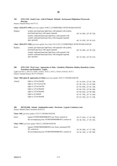
190 FINLAND - South Coast - Gulf of Finland - Helsinki - Korkeasaari Högholmen Westwards -<br />
Buoyage.<br />
Source: Finnish Notice 34/371/12<br />
Chart 2218 (INT 1159) [ previous update 4500/12 ] COMPATIBLE WITH WGS84 DATUM<br />
Replace<br />
symbol, port-hand spar light-buoy with <strong>to</strong>pmark with symbol,<br />
port-hand spar buoy with square <strong>to</strong>pmark<br />
symbol, starboard-hand spar light-buoy with <strong>to</strong>pmark with<br />
symbol, starboard-hand spar buoy with triangular <strong>to</strong>pmark<br />
apex upwards<br />
60° 10´·46N., 24° 58´·53E.<br />
60° 10´·42N., 24° 58´·61E.<br />
Chart 3818 (INT 1250) [ previous update New Chart 20/12/2012 ] COMPATIBLE WITH WGS84 DATUM<br />
Replace<br />
symbol, port-hand spar light-buoy with <strong>to</strong>pmark with symbol,<br />
port-hand spar buoy with square <strong>to</strong>pmark<br />
symbol, starboard-hand spar light-buoy with <strong>to</strong>pmark with<br />
symbol, starboard-hand spar buoy with triangular <strong>to</strong>pmark<br />
apex upwards<br />
60° 10´·46N., 24° 58´·53E.<br />
60° 10´·42N., 24° 58´·61E.<br />
200 FINLAND - West Coast - Approaches <strong>to</strong> Oulu - Länsilet<strong>to</strong>, Pikkulet<strong>to</strong>, Hoikka, Rautalet<strong>to</strong>, Löyha,<br />
Pensaskari and Runnilet<strong>to</strong> - Lights.<br />
Light List Vol. C, 2012/13, 4148.1, 4150.1, 4152.1, 4153.1, 4156.4, 4156.41, 4157.1<br />
Source: Finnish <strong>Notices</strong> 34/377-378/2012<br />
Chart 3062 (plan B, Approaches <strong>to</strong> Oulu) [ previous update 5645/12 ] WGS84 DATUM<br />
Amend light <strong>to</strong>, LFl.6s19m9M 65° 10´·83N., 25° 02´·70E.<br />
light <strong>to</strong>, LFl.Y.6s21m7M<br />
65° 08´·15N., 25° 03´·00E.<br />
light <strong>to</strong>, LFl.6s14m7M<br />
65° 05´·69N., 25° 02´·10E.<br />
light <strong>to</strong>, LFl.6s30m6M<br />
65° 06´·53N., 25° 08´·40E.<br />
light <strong>to</strong>, LFl.6s28m6M<br />
65° 06´·05N., 25° 08´·90E.<br />
light <strong>to</strong>, Q.10m6M<br />
65° 03´·70N., 25° 14´·64E.<br />
light <strong>to</strong>, LFl.6s26m6M<br />
65° 03´·24N., 25° 16´·10E.<br />
208 DENMARK - Islands - Smålandsfarvandet - S<strong>to</strong>rstrøm - Legend. Cautionary note.<br />
Source: Danish Chart Correction 48/416/12<br />
Chart 940 [ previous update 2332/12 ] WGS84 DATUM<br />
Insert legend, STORSTRØMSBROEN (see Note), centred on: 54° 57´·65N., 11° 54´·10E.<br />
the accompanying note, STORSTRØMSBROEN, centred on: 54° 48´·35N., 11° 58´·35E.<br />
Chart 2583 [ previous update 5664/12 ] WGS84 DATUM<br />
Insert<br />
legend, STORSTRØMSBROEN (see Note), orientated NW/<br />
SE, centred on:<br />
the accompanying note, STORSTRØMSBROEN, centred on:<br />
54° 58´·20N., 11° 51´·70E.<br />
54° 44´·10N., 11° 09´·50E.<br />
Wk02/13<br />
2.12


