Admiralty Notices to Mariners - United Kingdom Hydrographic Office
Admiralty Notices to Mariners - United Kingdom Hydrographic Office
Admiralty Notices to Mariners - United Kingdom Hydrographic Office
Create successful ePaper yourself
Turn your PDF publications into a flip-book with our unique Google optimized e-Paper software.
II<br />
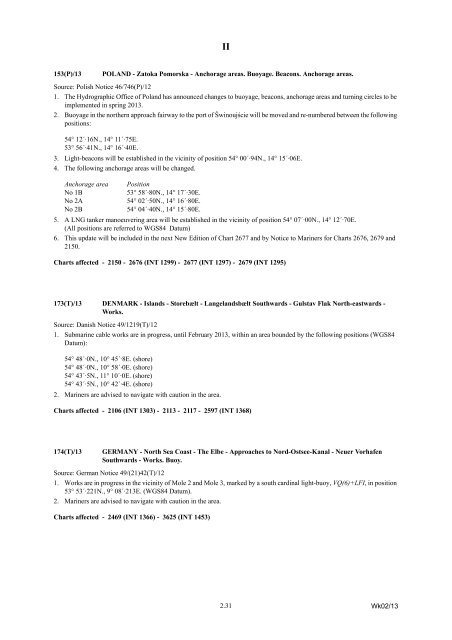
153(P)/13<br />
POLAND - Za<strong>to</strong>ka Pomorska - Anchorage areas. Buoyage. Beacons. Anchorage areas.<br />
Source: Polish Notice 46/746(P)/12<br />
1. The <strong>Hydrographic</strong> <strong>Office</strong> of Poland has announced changes <strong>to</strong> buoyage, beacons, anchorage areas and turning circles <strong>to</strong> be<br />
implemented in spring 2013.<br />
2. Buoyage in the northern approach fairway <strong>to</strong> the port of Świnoujście will be moved and re-numbered between the following<br />
positions:<br />
54° 12´·16N., 14° 11´·75E.<br />
53° 56´·41N., 14° 16´·40E.<br />
3. Light-beacons will be established in the vicinity of position 54° 00´·94N., 14° 15´·06E.<br />
4. The following anchorage areas will be changed.<br />
Anchorage area<br />
No 1B<br />
No 2A<br />
No 2B<br />
Position<br />
53° 58´·80N., 14° 17´·30E.<br />
54° 02´·50N., 14° 16´·80E.<br />
54° 04´·40N., 14° 15´·80E.<br />
5. A LNG tanker manoeuvering area will be established in the vicinity of position 54° 07´·00N., 14° 12´·70E.<br />
(All positions are referred <strong>to</strong> WGS84 Datum)<br />
6. This update will be included in the next New Edition of Chart 2677 and by Notice <strong>to</strong> <strong>Mariners</strong> for Charts 2676, 2679 and<br />
2150.<br />
Charts affected - 2150 - 2676 (INT 1299) - 2677 (INT 1297) - 2679 (INT 1295)<br />
173(T)/13 DENMARK - Islands - S<strong>to</strong>rebælt - Langelandsbælt Southwards - Gulstav Flak North-eastwards -<br />
Works.<br />
Source: Danish Notice 49/1219(T)/12<br />
1. Submarine cable works are in progress, until February 2013, within an area bounded by the following positions (WGS84<br />
Datum):<br />
54° 48´·0N., 10° 45´·8E. (shore)<br />
54° 48´·0N., 10° 58´·0E. (shore)<br />
54° 43´·5N., 11° 10´·0E. (shore)<br />
54° 43´·5N., 10° 42´·4E. (shore)<br />
2. <strong>Mariners</strong> are advised <strong>to</strong> navigate with caution in the area.<br />
Charts affected - 2106 (INT 1303) - 2113 - 2117 - 2597 (INT 1368)<br />
174(T)/13<br />
GERMANY - North Sea Coast - The Elbe - Approaches <strong>to</strong> Nord-Ostsee-Kanal - Neuer Vorhafen<br />
Southwards - Works. Buoy.<br />
Source: German Notice 49/(21)42(T)/12<br />
1. Works are in progress in the vicinity of Mole 2 and Mole 3, marked by a south cardinal light-buoy, VQ(6)+LFI, in position<br />
53° 53´·221N., 9° 08´·213E. (WGS84 Datum).<br />
2. <strong>Mariners</strong> are advised <strong>to</strong> navigate with caution in the area.<br />
Charts affected - 2469 (INT 1366) - 3625 (INT 1453)<br />
2.31<br />
Wk02/13


