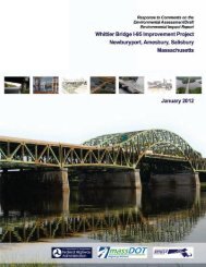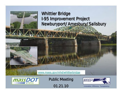
Whittier Bridge I-95 Improvement Project Newburyport/Amesbury ...
Whittier Bridge I-95 Improvement Project Newburyport/Amesbury ...
Whittier Bridge I-95 Improvement Project Newburyport/Amesbury ...

Create successful ePaper yourself
Turn your PDF publications into a flip-book with our unique Google optimized e-Paper software.
<strong>Whittier</strong> <strong>Bridge</strong><br />
I-<strong>95</strong> <strong>Improvement</strong> <strong>Project</strong><br />
<strong>Newburyport</strong>/<strong>Amesbury</strong>/Salisbury<br />
www.mass.gov/mhd/whittierbridge<br />
Public Meeting<br />
01.21.10<br />
Innovation, Efficiency, Transparency
<strong>Project</strong> Description<br />
MassDOT Proposes to Replace the Current Structurally<br />
Deficient John Greenleaf <strong>Whittier</strong> <strong>Bridge</strong> and Improve I-<strong>95</strong><br />
from Exit 57 (Rt 113) to Exit 59 (I-4<strong>95</strong>)<br />
• The 1<strong>95</strong>1 main span is a double-barreled, 3-span continuous<br />
riveted steel through truss.<br />
• Structurally Deficient, Nearing End of Economic Life<br />
• Poor Structural Rating , Excessive Deterioration<br />
• Non-redundant Structure<br />
• Geometrically Deficient<br />
• Highway<br />
• Insufficient Number of Lanes<br />
• Non-conforming Shoulder Width<br />
• Insufficient Number of Lanes<br />
• Exit 58 (Rt 110) Substandard Acceleration/Deceleration Lanes<br />
Innovation, Efficiency, Transparency
Accelerated <strong>Bridge</strong> Program<br />
• $3B commitment over 8 years<br />
• <strong>Whittier</strong> <strong>Bridge</strong> is a key component of the<br />
MassDOT Accelerated <strong>Bridge</strong> Program (ABP)<br />
• Goal to reduce the number of structurally<br />
deficient bridges over life of the program:<br />
– Remove Current <strong>Bridge</strong>s from List and,<br />
– Prevent Additional <strong>Bridge</strong>s from Becoming<br />
Classified Structurally Deficient<br />
Innovation, Efficiency, Transparency
<strong>Project</strong> Design Issues<br />
• <strong>Bridge</strong> River Crossings Options Drive<br />
<strong>Project</strong><br />
– Navigable Channels and River Hydraulics<br />
– Impact on Existing <strong>Bridge</strong><br />
– ROW Constraints/Impacts<br />
• Exit 58 (Rt 110)<br />
– <strong>Improvement</strong>s<br />
– Crossing Rail Trail<br />
• Northern Terminus Options<br />
– Lane Widening Terminus Options<br />
Innovation, Efficiency, Transparency
MEPA Environmental Notification<br />
Form (ENF) Comments<br />
• MEPA ENF Certificate – scope for the Draft EIR<br />
• 17 letters received with approximately 150 individual comments<br />
– Department of Environmental Protection<br />
– Massachusetts Historical Commission<br />
– Massachusetts Coastal Zone Management<br />
– Massachusetts Natural Heritage and Endangered Species Program<br />
– Department of Conservation and Recreation<br />
– Massachusetts Audubon Society<br />
– Merrimack Valley Planning Commission<br />
– City of <strong>Newburyport</strong> (multiple letters)<br />
– Town of Salisbury<br />
– Coastal Trails Coalition<br />
– 7 residents<br />
Innovation, Efficiency, Transparency
Seven Major Areas of Comment<br />
1.Justification of Need for <strong>Project</strong><br />
2.Alternatives Analysis to Identify Preferred<br />
Alternative<br />
3.Analyze Impacts to River Navigation from<br />
Construction and New <strong>Bridge</strong><br />
4.Accommodation of bicycle/ recreational trails in<br />
project area<br />
5.Stormwater Impacts<br />
6.Rare Species Impacts<br />
7.Wetlands Impacts<br />
Innovation, Efficiency, Transparency
Major Areas of Comment in Detail<br />
1. Justification of Need for <strong>Project</strong><br />
1. <strong>Bridge</strong> Replacement – document existing condition of bridge and<br />
whether rehabilitation is possible<br />
2. Highway Widening – document need for additional lanes<br />
2. Alternatives Analysis to Identify Preferred Alternative<br />
1. Existing <strong>Bridge</strong>: Rehabilitation; Rehabilitation with Retrofitting;<br />
Retain <strong>Bridge</strong> with Adjacent New Construction<br />
2. New <strong>Bridge</strong>: East; West; East-West; New 6-Lane <strong>Bridge</strong><br />
3. Highway: Widen Inside; Widen Outside; Widen to Rte. 110 Only<br />
3. Analyze Impacts to River Navigation from Construction<br />
and New <strong>Bridge</strong><br />
Innovation, Efficiency, Transparency
Major Areas of Comment in Detail<br />
4. Accommodation of bicycle/ recreational trails in project area<br />
1. East – West Corridor to connect to Maudslay State Park<br />
2. North – South connection across Merrimack River<br />
3. Accommodate Connections to Existing Trails<br />
5. Stormwater Impacts<br />
1. Compliance with Stormwater Standards<br />
2. Protection of Existing Drinking Water Supplies<br />
6. Rare Species Impacts<br />
1. Sturgeon<br />
2. Bald Eagles<br />
7. Wetlands Impacts<br />
1. Demonstrate Need for Wetlands Variance if Necessary<br />
2. Avoid Impacts if Possible<br />
Innovation, Efficiency, Transparency
Purpose and Need<br />
• Address Structural Deficiency of the Existing<br />
<strong>Whittier</strong> <strong>Bridge</strong><br />
– Current Structure has a poor structural rating<br />
– Feasibility of Rehabilitation is under review<br />
• Address Geometric Deficiencies from Exit 57<br />
to Exit 60<br />
– Lack of Shoulders on <strong>Whittier</strong> <strong>Bridge</strong><br />
– Highway Capacity impacted by insufficient lanes<br />
– Exit 58 thru 60 – On and Off Ramps<br />
Innovation, Efficiency, Transparency
Rehabilitation Assessment<br />
• Rehabilitation Feasibility<br />
Assessment Report is in<br />
Under Review<br />
Innovation, Efficiency, Transparency
Safety/Roadway Deficiencies<br />
• Related to:<br />
– Congestion Level of Service (LOS)<br />
– Roadway Geometry<br />
• Lane width<br />
• Shoulder width<br />
• Roadside Obstacles<br />
– Roadway Condition<br />
• Defects<br />
• Weather/Environmental<br />
Innovation, Efficiency, Transparency
I-<strong>95</strong> South Bound (SB)<br />
Accident Data 2005 - 2009<br />
Accident Clusters<br />
• Exit 60 On Ramp<br />
• Exit 59 Off Ramps<br />
• Exit 58 Off Ramp<br />
• Exit 58 On Ramp<br />
• Exit 58 On Ramp<br />
• <strong>Whittier</strong> <strong>Bridge</strong><br />
Innovation, Efficiency, Transparency
I-<strong>95</strong> SB Accident Data<br />
2005 - 2009<br />
Accident Clusters<br />
Exit 60 On Ramp<br />
Exit 59 Off Ramps<br />
Addressed by <strong>Improvement</strong>s<br />
Innovation, Efficiency, Transparency
I-<strong>95</strong> SB Accident Data<br />
2005 - 2009<br />
Accident Clusters<br />
Exit 58 Off Ramp<br />
Exit 58 On Ramp<br />
Exit 58 On Ramp<br />
<strong>Whittier</strong> <strong>Bridge</strong><br />
Addressed by <strong>Improvement</strong>s<br />
Innovation, Efficiency, Transparency
I-<strong>95</strong> North Bound (NB)<br />
Accident Data 2005 - 2009<br />
Accident Clusters<br />
• Exit 60 On Ramp<br />
• Exit 60 Off Ramp<br />
• Exit 59 On Ramps<br />
• Exit 58 Of Ramp<br />
• I-<strong>95</strong> Reverse Curve<br />
• <strong>Whittier</strong> <strong>Bridge</strong> and Approach<br />
Innovation, Efficiency, Transparency
I-<strong>95</strong> NB Accident Data<br />
2005 - 2009<br />
Accident Clusters<br />
Exit 60 On Ramp<br />
Exit 60 Off Ramp<br />
Exit 59 On Ramps<br />
Addressed by <strong>Improvement</strong>s<br />
Innovation, Efficiency, Transparency
I-<strong>95</strong> NB Accident Data<br />
2005 - 2009<br />
Accident Clusters<br />
Exit 58 On Ramp<br />
Exit 58 Off Ramp<br />
I-<strong>95</strong> Reverse Curve<br />
<strong>Whittier</strong> <strong>Bridge</strong> and<br />
Approach<br />
Addressed by <strong>Improvement</strong>s<br />
Innovation, Efficiency, Transparency
Design is Driven by Weekend<br />
Traffic Volumes<br />
Innovation, Efficiency, Transparency
Innovation, Efficiency, Transparency
Design Level of Service (LOS)<br />
LOS C<br />
LOS D<br />
LOS E<br />
20<br />
Innovation, Efficiency, Transparency
Historic Traffic Growth on<br />
<strong>Whittier</strong> <strong>Bridge</strong><br />
Converted to 3 Lanes<br />
Innovation, Efficiency, Transparency
Affected Environment Studied<br />
• Cultural Resources Documented<br />
• River Hydraulics Being Modeled<br />
• Wetlands Delineated and Concurred by<br />
Local Town Conservation Commissions<br />
• Stormwater Impacts Under Review<br />
• Water Supply Protection Zones Mapped<br />
• Noise Baseline Data Being Analyzed<br />
• Air Quality Model is Under Development<br />
Innovation, Efficiency, Transparency
Historic Resources<br />
Reconnaissance Survey<br />
•Purpose and Need<br />
Innovation, Efficiency, Transparency
Historic Resources<br />
Innovation, Efficiency, Transparency
Hydraulics Study Area<br />
Innovation, Efficiency, Transparency
Navigation Channels/Bathymetry<br />
Innovation, Efficiency, Transparency
Downstream Marine Facilities<br />
Innovation, Efficiency, Transparency
Upstream Marine Facilities<br />
Innovation, Efficiency, Transparency
Marine Borings<br />
Innovation, Efficiency, Transparency
Existing & Planned Trails<br />
• Ghost Trail<br />
• East-West<br />
connections at<br />
Moseley Woods<br />
and Pine Hill Rd<br />
Innovation, Efficiency, Transparency
Innovation, Efficiency, Transparency
Moseley Woods<br />
• Possible Enhanced East – West<br />
Connection<br />
• Possible Stormwater Treatment<br />
Easement<br />
Innovation, Efficiency, Transparency
Watersheds<br />
• Drainage Zone 1 – Directly tributary to<br />
the Merrimack River, 1 - 30” outlet south<br />
of the River.<br />
• Drainage Zone 2 – <strong>Bridge</strong>, Tributary to<br />
the Merrimack River<br />
• Drainage Zone 3 – Multiple outlets which<br />
discharge to BVW located on both sides<br />
of the existing alignment, tributary to the<br />
Merrimack River.<br />
• Drainage Zone 4 – Multiple outlets which<br />
discharge to BVW located on both sides<br />
of the roadway and are tributary to<br />
Meader Brook. There is a small section of<br />
roadway in the southern portion of Zone 4<br />
which discharges to an unnamed stream<br />
on the west side of the southbound<br />
corridor and flows to the Merrimack River.<br />
• Drainage Zone 5 – Tributary to Cain’s<br />
Brook.<br />
<strong>Project</strong> Limit<br />
<strong>Project</strong> Limit<br />
Innovation, Efficiency, Transparency
Innovation, Efficiency, Transparency
Innovation, Efficiency, Transparency
<strong>Newburyport</strong> Water Protection<br />
Zones<br />
Surface Water Protection Zone A<br />
(Impacts must be avoided)<br />
ORW - Outstanding Resource Waters Limit<br />
(Impacts to be avoided, minimized or<br />
mitigated, may require a DEP Variance)<br />
Innovation, Efficiency, Transparency
Innovation, Efficiency, Transparency
Southern Wetlands<br />
•<strong>Newburyport</strong><br />
–Salt Marsh<br />
•<strong>Amesbury</strong><br />
–Salt Marsh<br />
–Bordering Vegetated Wetland<br />
(BVW)<br />
Innovation, Efficiency, Transparency
Northern Wetlands<br />
•Salisbury<br />
•Bordering Vegetated Wetland<br />
(BVW)<br />
Innovation, Efficiency, Transparency
Alternatives Development<br />
• Eight <strong>Bridge</strong> Crossing<br />
Alternatives<br />
• Four Northern<br />
Widening Alternatives<br />
Innovation, Efficiency, Transparency
ALTERNATIVES SCREENING<br />
A Two-Step Screening Process to Evaluate River<br />
Crossing and Highway Widening Alternatives<br />
• 1st Phase Screening:<br />
– River Crossing Alternatives<br />
– Highway Alternatives<br />
• 2nd Phase Screening:<br />
– River Crossing Alternatives<br />
– Highway Alternatives<br />
Innovation, Efficiency, Transparency
1st Phase Screening<br />
Screening Factors Applied<br />
• Purpose & Need<br />
• Highway Configuration<br />
• <strong>Bridge</strong> Configuration<br />
• Traffic<br />
• Right of Way<br />
• Cost<br />
• Construction<br />
• Schedule<br />
• Environmental Factors<br />
Innovation, Efficiency, Transparency
1 st Phase Alternatives<br />
• River Crossing Alternatives<br />
– No Build<br />
– Progressive<br />
– Rehabilitation<br />
– Retrofit with Adjacent Structure<br />
– New 6-Lane <strong>Bridge</strong><br />
– New 8-Lane East-West <strong>Bridge</strong><br />
– New 8-Lane East <strong>Bridge</strong><br />
– New 8-Lane West <strong>Bridge</strong><br />
Innovation, Efficiency, Transparency
1 st Phase Alternatives (cont.)<br />
• Highway Alternatives<br />
– Inside Widening<br />
– Outside Widening<br />
– Inside Northbound/Outside Southbound<br />
– Outside Northbound/Inside Southbound<br />
– Northern Terminus to Route 110<br />
Innovation, Efficiency, Transparency
East Alternative<br />
•Girder <strong>Bridge</strong>s<br />
•Concrete Segmental Box Girder<br />
•Steel Plate Girders<br />
•Steel Box Girders<br />
•Multi-Box<br />
•Single Box<br />
Innovation, Efficiency, Transparency
Segmental Concrete Option<br />
Innovation, Efficiency, Transparency
Segmental Concrete Option<br />
Innovation, Efficiency, Transparency
East Alternative<br />
• Implementation Example<br />
• 2 Construction Phases<br />
• 1 Demolition Phase<br />
Innovation, Efficiency, Transparency
East - West Side Concept<br />
•Girder <strong>Bridge</strong>s<br />
•Concrete Segmental Box Girder<br />
•Steel Plate Girders<br />
•Steel Box Girders<br />
•Multi-Box<br />
•Single Box<br />
Innovation, Efficiency, Transparency
• NB and SB Treatments<br />
Can Differ<br />
• Take Advantage of 60‘<br />
Wide Median<br />
• Minimize Impacts to<br />
Route 110 Ramp<br />
Terminals<br />
• Horizontal Curve<br />
Location<br />
• <strong>Bridge</strong> Pier Constraints<br />
I-<strong>95</strong> Widening<br />
Inside vs. Outside<br />
Innovation, Efficiency, Transparency
Northerly Terminus<br />
Exit 60<br />
• NB Widening Limits are<br />
More Complex Than SB<br />
• Lane Balance NB at<br />
I-<strong>95</strong>/I-4<strong>95</strong><br />
• Several Options<br />
Investigated<br />
• Keep Limits in Check<br />
I-<strong>95</strong>N at I-4<strong>95</strong> I<br />
Overpass<br />
Innovation, Efficiency, Transparency
Northerly Terminus<br />
• Option 1<br />
– Maintains 4 Lanes NB Through I-4<strong>95</strong> Merge<br />
– Complies w/Lane Balance Principles<br />
– Adds Auxiliary Lane Between Interchanges<br />
– Potentially Impacts Several <strong>Bridge</strong>s<br />
Innovation, Efficiency, Transparency
I-<strong>95</strong> Widening - Inside vs.<br />
Outside<br />
• NB and SB Widening Options<br />
– Widen NB & SB to Inside of Existing Median<br />
• Avoids Wetland Impacts at Edge of ROW<br />
• Avoids Abutter Impacts at Edge of ROW<br />
• Avoids Impacts to Northern <strong>Bridge</strong>s<br />
• Reduces Width of Median<br />
Innovation, Efficiency, Transparency
2nd Phase Screening<br />
• Screening Factors Applied:<br />
– Land Use and Visual<br />
– Open Space and Recreation<br />
– Traffic and Safety<br />
– Air Quality<br />
– Noise<br />
– Water Resources<br />
– Fisheries<br />
– Wildlife<br />
Innovation, Efficiency, Transparency
2nd Phase Screening (cont.)<br />
2nd Phase Screening continued…<br />
• Wetlands<br />
• Floodplains<br />
• Historical and Archaeological<br />
– Coordination with MHC to Follow<br />
• Oil and Hazardous Materials<br />
• Utilities<br />
• Economics<br />
• Permits<br />
• Right of Way<br />
• Cost<br />
Screening Underway and Will Lead to Selection of a Preferred Alternative in<br />
the DEIR/EA<br />
Innovation, Efficiency, Transparency
2nd Phase Alternatives<br />
• <strong>Bridge</strong> Crossing Alternatives<br />
– No Build<br />
– New 8-Lane East River Crossing<br />
– New 8-Lane East-West River Crossing<br />
• Highway Alternatives<br />
– Inside Widening (moved forward as part of all<br />
River Crossing Alternative)<br />
Innovation, Efficiency, Transparency
Preferred <strong>Bridge</strong> Crossing &<br />
Alignment Alternative<br />
• The Environmental Process will result in a<br />
Preferred Alternative that will be fully<br />
Documented and presented through the<br />
MEPA/NEPA Process in a combined<br />
– Public Review of DEIR/EA in the Fall of 2010<br />
– Followed-up with FEIR and an Administrative Record<br />
in order to receive<br />
• NEPA FONSI<br />
• MEPA Certificate<br />
Innovation, Efficiency, Transparency
Next Steps<br />
• Preferred Alignment Alternative<br />
– Inside Widening Highway Widening Alternative<br />
– Finalize River Crossing Alternative<br />
• Preferred <strong>Bridge</strong> Alternative<br />
• The MEPA/ NEPA Process will result in the<br />
selection of the Preferred <strong>Project</strong> Alternative<br />
Innovation, Efficiency, Transparency
<strong>Bridge</strong> View Perspectives<br />
<strong>Amesbury</strong> Main St Captains Park<br />
Innovation, Efficiency, Transparency
<strong>Bridge</strong> View Perspectives<br />
<strong>Newburyport</strong> Moseley Woods Overlook<br />
Innovation, Efficiency, Transparency
<strong>Bridge</strong> View Perspectives<br />
Merrimack River Chain <strong>Bridge</strong><br />
Innovation, Efficiency, Transparency
Box Girder<br />
Innovation, Efficiency, Transparency
Box Girder<br />
Innovation, Efficiency, Transparency
Box Girder<br />
Innovation, Efficiency, Transparency
Cable Stay<br />
Innovation, Efficiency, Transparency
Cable Stay<br />
Innovation, Efficiency, Transparency
Cable Stay<br />
Innovation, Efficiency, Transparency
Single Extradosed<br />
Innovation, Efficiency, Transparency
Single Extradosed<br />
Innovation, Efficiency, Transparency
Single Extradosed<br />
Innovation, Efficiency, Transparency
Double Extradosed<br />
Innovation, Efficiency, Transparency
Double Extradosed<br />
Innovation, Efficiency, Transparency
Double Extradosed<br />
Innovation, Efficiency, Transparency
Network Tied Arch<br />
Innovation, Efficiency, Transparency
Network Tied Arch<br />
Innovation, Efficiency, Transparency
Network Tied Arch<br />
Innovation, Efficiency, Transparency
Public Process<br />
• Local Government Briefings Spring 2009<br />
• MEPA Public Mtg 6.18.09<br />
• Stakeholders Mtg. 12.07.09<br />
• Public Mtg 1.21.10<br />
• Going Forward Public Mtgs Quarterly:<br />
1. January (1.21.10)<br />
2. April<br />
3. July<br />
4. October<br />
Innovation, Efficiency, Transparency
<strong>Project</strong> Schedule<br />
• Started Environmental Study Options: Nov 2008<br />
– Data Acquisition; Field Studies, Survey, Research,…<br />
• Started Public Outreach: March 2009<br />
• Filed ENF: June 1, 2009<br />
• Public Review of DEIR/EA: Fall 2010<br />
• File FEIR: Spring 2011<br />
• MEPA/NEPA Approvals: Summer 2011<br />
• Design Public Hearing: Fall 2011<br />
• Adv Design/Build contract: Spring 2012<br />
• Construction Start: Winter 2013<br />
Innovation, Efficiency, Transparency
Questions & Answers<br />
www.mass.gov/mhd/whittierbridge.<br />
Innovation, Efficiency, Transparency
To submit comments or request more<br />
information, please contact:<br />
Frank A. Tramontozzi, P.E., Chief Engineer<br />
Attn: Shoukry A. Elnahal, P.E<br />
Director of Accelerated <strong>Bridge</strong> Program<br />
Massachusetts Department of Transportation - Highway Division<br />
10 Park Plaza<br />
Boston, MA 02116<br />
617-973-7800<br />
To be added to the project distribution database, please contact:<br />
Stephanie Boundy, Public Outreach Coordinator<br />
MassDOT, Accelerated <strong>Bridge</strong> Program<br />
617-973-8049 or Stephanie.Boundy@state.ma.us<br />
Innovation, Efficiency, Transparency