

Assam - Ministry of Environment and Forests
Assam - Ministry of Environment and Forests
Assam - Ministry of Environment and Forests

Create successful ePaper yourself
Turn your PDF publications into a flip-book with our unique Google optimized e-Paper software.
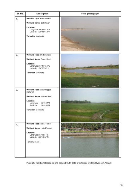
Sr. No.<br />
5.<br />
Description<br />
Wetl<strong>and</strong> Type: River/streem<br />
Wetl<strong>and</strong> Name: Beki River<br />
Location:<br />
Longitude: 90°55’02.6”E<br />
Latitude : 26°31’01.5”N<br />
Turbidity: Moderate<br />
Field photograph<br />
2.<br />
Wetl<strong>and</strong> Type: Ox-bow lake<br />
Wetl<strong>and</strong> Name: Saren Beel<br />
Location:<br />
Longitude: 91°46’42.5”E<br />
Latitude : 26°06’46” N<br />
Turbidity: Moderate<br />
3.<br />
Wetl<strong>and</strong> Type: Waterlogged<br />
(natura)l<br />
Wetl<strong>and</strong> Name: Naitara Beel<br />
Location:<br />
Longitude : 90°59.07”E<br />
Latitude : 26°03.16’N<br />
Turbidity: Moderate<br />
4.<br />
Wetl<strong>and</strong> Type: Tank / Pond<br />
Wetl<strong>and</strong> Name: Hajo Pukhuri<br />
Location:<br />
Longitude: 91°31’54”E<br />
Latitude : 26°14’36”N<br />
Turbidity : Low<br />
Plate 2b: Field photographs <strong>and</strong> ground truth data <strong>of</strong> different wetl<strong>and</strong> types in <strong>Assam</strong><br />
124


