

Assam - Ministry of Environment and Forests
Assam - Ministry of Environment and Forests
Assam - Ministry of Environment and Forests

You also want an ePaper? Increase the reach of your titles
YUMPU automatically turns print PDFs into web optimized ePapers that Google loves.
7.1.2 Dhubri<br />
The district is situated in the extreme south western part <strong>of</strong> the lower Brahmaputra valley <strong>of</strong> <strong>Assam</strong> between<br />
25°30'N <strong>and</strong> 26°30'N latitude <strong>and</strong> 89°40'E <strong>and</strong> 90 o 30'E longitude, with an area <strong>of</strong> 2, 67,572 hectares. The<br />
district is characterised by almost flat topography but the eastern part has an undulating topography.The<br />
drainage system is dominated by the Brahmaputra river that flows through the district with a sharp south turn<br />
in the extreme west end <strong>of</strong> the district. The northern part is having a number <strong>of</strong> tributaries <strong>of</strong> the Brahmaputra<br />
namely Champamati, Gourang, Tipkai, Godadhar <strong>and</strong> Sonkosh which are perennial in nature, originate from<br />
Bhutan <strong>and</strong> flow into the Brahmaputra towards south. Among the southern tributaries, the Jinjiram originates'<br />
from Urpad beel <strong>of</strong> Goalpara district <strong>and</strong> flows parallel to the Brahmaputra for some distance before joining<br />
further downstream. The soil in the northern part <strong>of</strong> the district is composed <strong>of</strong> Recent Riverine Alluvial soils<br />
(Entiso1s), <strong>and</strong> that <strong>of</strong> the lowermost part <strong>of</strong> the district is formed by Old Riverine Alluvial soils (Inceptiso1s).<br />
The soil pH <strong>of</strong> the district varies from 4.5 to 7.5 i.e. acidic to neutral. The annual average rainfall <strong>of</strong> the district<br />
is 2647, mm. The maximum <strong>and</strong> minimum temperature <strong>of</strong> the district is 38°C <strong>and</strong> 7°C respectively. As per<br />
2001 Census, the district has a total population <strong>of</strong> 16, 37,344.<br />
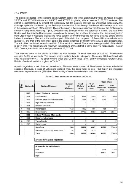
Total wetl<strong>and</strong> area in the district is 56464 ha that includes 74 small wetl<strong>and</strong>s (


