

Assam - Ministry of Environment and Forests
Assam - Ministry of Environment and Forests
Assam - Ministry of Environment and Forests

You also want an ePaper? Increase the reach of your titles
YUMPU automatically turns print PDFs into web optimized ePapers that Google loves.
<strong>and</strong> emergent. It is possible to delineate last two types <strong>of</strong> vegetation using optical remote sensing data.<br />
A qualitative layer pertaining to presence <strong>of</strong> vegetation is generated for each season (as manifested on<br />
pre-monsoon <strong>and</strong> post-monsoon imagery).<br />
• Turbidity <strong>of</strong> open water: A layer pertaining to a qualitative turbidity rating is generated.<br />
Three qualitative turbidity ratings ( low, medium <strong>and</strong> high) is followed for pre- <strong>and</strong> post-monsoon<br />
turbidity <strong>of</strong> lakes, reservoirs, barrages <strong>and</strong> other large wetl<strong>and</strong>s.<br />
• Small wetl<strong>and</strong>s (smaller than minimum mappable unit: < 2.25 ha) are mapped as point features.<br />
• Base layers like major road network, railway, settlements, <strong>and</strong> surface drainage are created (either from<br />
the current image or taken from other project data base).<br />
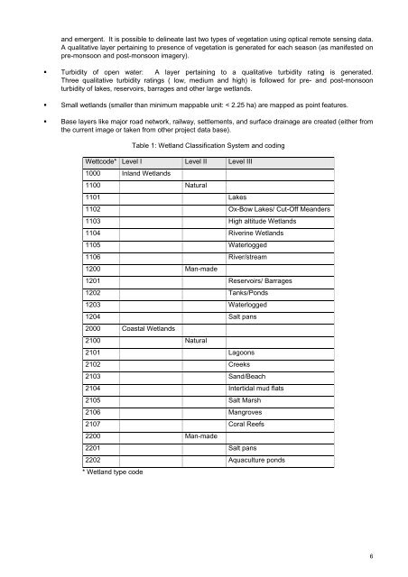
Table 1: Wetl<strong>and</strong> Classification System <strong>and</strong> coding<br />
Wettcode* Level I Level II Level III<br />
1000 Inl<strong>and</strong> Wetl<strong>and</strong>s<br />
1100 Natural<br />
1101 Lakes<br />
1102 Ox-Bow Lakes/ Cut-Off Me<strong>and</strong>ers<br />
1103 High altitude Wetl<strong>and</strong>s<br />
1104 Riverine Wetl<strong>and</strong>s<br />
1105 Waterlogged<br />
1106 River/stream<br />
1200 Man-made<br />
1201 Reservoirs/ Barrages<br />
1202 Tanks/Ponds<br />
1203 Waterlogged<br />
1204 Salt pans<br />
2000 Coastal Wetl<strong>and</strong>s<br />
2100 Natural<br />
2101 Lagoons<br />
2102 Creeks<br />
2103 S<strong>and</strong>/Beach<br />
2104 Intertidal mud flats<br />
2105 Salt Marsh<br />
2106 Mangroves<br />
2107 Coral Reefs<br />
2200 Man-made<br />
2201 Salt pans<br />
2202 Aquaculture ponds<br />
* Wetl<strong>and</strong> type code<br />
6


