

mcbem-2014-01-submission-wwf-en
mcbem-2014-01-submission-wwf-en
mcbem-2014-01-submission-wwf-en

You also want an ePaper? Increase the reach of your titles
YUMPU automatically turns print PDFs into web optimized ePapers that Google loves.
II - FRAMING THE ISSUES<br />
Curr<strong>en</strong>t and Proposed Projects with Underwater Noise: Implications for the North and C<strong>en</strong>tral Coast<br />
Mike Ambach, WWF-Canada<br />
The curr<strong>en</strong>t trajectory of the marine transport industry in the North and C<strong>en</strong>tral Coast of British<br />
Columbia points to a 100% increase in large vessel traffic by 2020 with continued future growth. A shift<br />
towards larger and newer vessels, including more container ship traffic and LNG-carrying vessels, would<br />
change the overall profile and makeup of the range of vessels plying these waters. In particular, three<br />
port communities – Stewart, Prince Rupert, and Kitimat – are each poised for, or already undergoing,<br />
significant expansion plans. Corresponding foreshore developm<strong>en</strong>t to accommodate growth in this<br />
sector will also impact coastal values such as commercial fishing, recreational use, and habitat value.<br />
The drivers of this growth are largely related to the burgeoning Asian market. Asian demand for <strong>en</strong>ergy<br />
products and commodities, as well as import of processed goods, is expected to grow. The significance<br />
of this increase in shipping d<strong>en</strong>sity has implications for species dep<strong>en</strong>d<strong>en</strong>t on acoustic habitat. The<br />
water bodies of Dixon Entrance, Chatham Sound, Douglas Channel and Caamaño Sound, as well as the<br />
adjoining Hecate Strait and Que<strong>en</strong> Charlotte Sound, will all be subject to increased noise from shipping.<br />
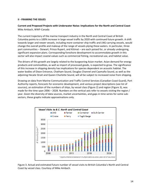
Drawing on data from Marine Communication and Traffic Control Services (Canadian Coast Guard), Port<br />
Authority reports, forecasts for economic developm<strong>en</strong>t, and various project descriptions (see list of<br />
sources), an estimation of the numbers of ships, by vessel class (Figure 2) and region (Figure 3), was<br />
made for the time span 2006 – 2028. Numbers on the vertical axis refer to vessels visiting the region /<br />
year. Giv<strong>en</strong> the diversity of data sources, market uncertainties, and gaps in time series for some subsectors,<br />
these graphs indicate approximations only.<br />
Figure 3. Actual and estimated future number of vessel visits to British Columbia’s North and C<strong>en</strong>tral<br />
Coast by vessel class. Courtesy of Mike Ambach.<br />
14