Introduction to the resistivity surveying method. The resistivity of ...
Introduction to the resistivity surveying method. The resistivity of ...
Introduction to the resistivity surveying method. The resistivity of ...

Create successful ePaper yourself
Turn your PDF publications into a flip-book with our unique Google optimized e-Paper software.
51<br />
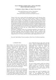
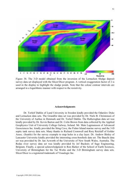
Figure 38. <strong>The</strong> 3-D model obtained from <strong>the</strong> inversion <strong>of</strong> <strong>the</strong> Lernacken Sludge deposit<br />
survey data set displayed with <strong>the</strong> Slicer/Dicer program. A vertical exaggeration fac<strong>to</strong>r <strong>of</strong> 2 is<br />
used in <strong>the</strong> display <strong>to</strong> highlight <strong>the</strong> sludge ponds. Note that <strong>the</strong> colour con<strong>to</strong>ur intervals are<br />
arranged in a logarithmic manner with respect <strong>to</strong> <strong>the</strong> <strong>resistivity</strong>.<br />
Acknowledgments<br />
Dr. Torleif Dahlin <strong>of</strong> Lund University in Sweden kindly provided <strong>the</strong> Odarslov Dyke<br />
and Lernacken data sets. <strong>The</strong> Grundfor data set was provided by Dr. Niels B. Christensen <strong>of</strong><br />
<strong>the</strong> University <strong>of</strong> Aarhus in Denmark and Dr. Torleif Dahlin. <strong>The</strong> Rathcroghan data set was<br />
kindly provided by Dr. Kevin Bar<strong>to</strong>n and Dr. Colin Brown from data collected by <strong>the</strong> Applied<br />
Geophysics Unit <strong>of</strong> University College Galway, Ireland. Mr. Mats Lagmansson <strong>of</strong> Advanced<br />
Geosciences Inc. kindly provided <strong>the</strong> Sting Cave, <strong>the</strong> Fisher Island marine survey and <strong>the</strong> 3-D<br />
septic tank survey data sets. Many thanks <strong>to</strong> Richard Cromwell and Rory Retzlaff <strong>of</strong> Golder<br />
Assoc. (Seattle) for <strong>the</strong> survey example <strong>to</strong> map holes in a clay layer. Dr. Andrew Binley <strong>of</strong><br />
Lancaster University kindly provided <strong>the</strong> interesting cross-borehole data set. <strong>The</strong> Bauchi data<br />
set was provided by Dr. Ian Acworth <strong>of</strong> <strong>the</strong> University <strong>of</strong> New South Wales, Australia. <strong>The</strong><br />
Redas river survey data set was kindly provided by Jef Bucknix <strong>of</strong> Sage Engineering,<br />
Belgium. Finally, a special acknowledgment <strong>to</strong> Ron Barker <strong>of</strong> <strong>the</strong> School <strong>of</strong> Earth Sciences,<br />
University <strong>of</strong> Birmingham for <strong>the</strong> Tar Works and <strong>the</strong> 3-D Birmingham survey data sets.<br />
Slicer/Dicer is a registered trademark <strong>of</strong> Visualogic Inc.<br />
Copyright (1999-2001) M.H.Loke