
Create successful ePaper yourself
Turn your PDF publications into a flip-book with our unique Google optimized e-Paper software.
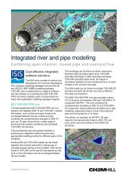
<strong>TUFLOW</strong><br />
Flood and tide simulation software<br />
CH2M HILL is a UK distributor for BMT WBM’s<br />
<strong>TUFLOW</strong> software. By purchasing <strong>TUFLOW</strong><br />
from CH2M HILL, users benefit from having<br />
access to CH2M HILL’s UK based support team<br />
at no extra cost!<br />
Floods and storm tides cause extensive damage,<br />
stress, loss of life and displace communities. To<br />
understand and manage these risks requires software<br />
that accurately models inundation of rivers, urban<br />
areas and coastal floodplains. <strong>TUFLOW</strong> meets this<br />
challenge effectively, reliably and within an<br />
economical cost structure.<br />
A proven and reliable solution<br />
<strong>TUFLOW</strong> is a powerful one-dimensional/twodimensional1D/2D<br />
hydrodynamic computational<br />
engine that simulates river, estuarine and coastal flow.<br />
With superior 1D/2D dynamic linking capabilities,<br />
robustness, established performance and wide<br />
ranging functionality, it is ideally suited to modelling<br />
flooding from multiple sources, including:<br />
direct rainfall and surface water<br />
urban stormwater drainage networks<br />
fluvial flooding from rivers and streams<br />
storm tide and tsunami inundation<br />
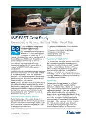
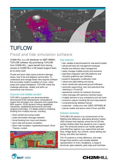
Storm tide inundation: hypothetical breach, River<br />
Thames, London<br />
Key features<br />
fast, reliable & benchmarked for real-world models<br />
advanced flood risk management analyses<br />
flexible and effective data management<br />
easily manage multiple events and scenarios<br />
seamless integration with GIS platforms and<br />
3rd party graphical user interfaces<br />
powerful topography modification tools<br />
robust and rapid wetting and drying<br />
direct rainfall with advanced ground infiltration<br />
automatic supercritical, weir and subcritical flow<br />
switching in 1D and 2D<br />
operational controls for hydraulic structures<br />
urban drainage with advance manhole losses<br />
multiple domains of any orientations and cell sizes<br />
extensive outputs including QA and mass balance<br />
comprehensively detailed manual<br />
customise - create your own USER_DEFINED.dll<br />
tutorial models and active online Forum and Wiki<br />
Solution schemes<br />
<strong>TUFLOW</strong>’s 2D solution is an enhancement of the<br />
Stelling finite difference, alternating direction implicit<br />
(ADI) scheme that implicitly solves the full 2D free<br />
surface shallow water flow equations over a regular<br />
grid. The enhanced scheme can handle upstream<br />
controlled flow regimes (e.g. supercritical and weir<br />
flow), bridge decks, box culverts, robust wetting and<br />
drying, and other key features.<br />
The 1D scheme is a finite difference, 2nd order,<br />
Runge-Kutta solution and includes detailed<br />
representation of rivers, floodplains, a range of<br />
structures, pipe networks, gully traps and manholes.
Dynamic linking<br />
The dynamic linking capability between 2D and 1D<br />
domains are the most powerful, reliable and functional<br />
on offer. Links are easily setup to interface between<br />
1D rivers and 2D floodplains, overland urban flooding<br />
and pipe networks, and for embedding 1D hydraulic<br />
structures.<br />
any orientation to the 2D grid, start completely dry,<br />
and wet and dry during the simulation.<br />
apply the full 2D solution, instead of substituting a<br />
weir equation, and preserve momentum<br />
do not force a reduction of the 2D timestep or need<br />
to be reworked if the 2D cell size changes.<br />
Links to other software<br />
the ISIS-<strong>TUFLOW</strong>-PIPE link enables models built<br />
in ISIS 1D to be dynamically linked to <strong>TUFLOW</strong> and<br />
its 1D component, ESTRY, offering unparalleled<br />
performance hydraulic modelling<br />
produce flood maps and animated flood sequences<br />
using ISIS MAPPER (available for free)<br />
construct models using ISIS MAPPER, SMS<br />
Graphical User Interfaces or other GIS software<br />
Depth and velocity outputs from ISIS-<strong>TUFLOW</strong>-PIPE<br />
<strong>TUFLOW</strong> Advection Dispersion<br />
The <strong>TUFLOW</strong> Advection Dispersion (<strong>TUFLOW</strong> AD)<br />
module simulates depth-averaged, 1D and 2D<br />
constituent fate and transport. Applications include<br />
mixing in inland waterways, fate of plumes and<br />
flushing assessments.<br />
MapInfo and <strong>TUFLOW</strong> productivity tools<br />
MapInfo and <strong>TUFLOW</strong> productivity tools (miTools)<br />
have been developed to improve the efficiency of<br />
setting up and reviewing <strong>TUFLOW</strong> models, as well as<br />
improving the day to day ease of using MapInfo. It<br />
enables ‘automation’ of many of the common<br />
repetitive tasks, saving time and money.<br />
Multiple 2D Domains<br />
The Multiple 2D Domains module allows any number<br />
of 2D domains of different cell size and orientation to<br />
be built into a model. The 2D domains can be linked<br />
by 1D domains, or via the 2D/2D linking feature.<br />
Levee Impact Assessment at the start, during and peak of the flood.<br />
Richmond River, New South Wales. Yellow indicates