2013 - Geoinformatics
2013 - Geoinformatics
2013 - Geoinformatics

You also want an ePaper? Increase the reach of your titles
YUMPU automatically turns print PDFs into web optimized ePapers that Google loves.
19<br />
not only collect information, but also perform<br />
in-depth crop yield analysis, transforming<br />
massive amounts of data into useable<br />
information.<br />
The acquisition also transformed Intergraph<br />
internally. Hexagon already owned the leading<br />
remote sensing software provider, ERDAS,<br />
and its integration into Intergraph created a<br />
unique scope of capabilities (spanning GIS,<br />
remote sensing, and photogrammetry). The<br />
new <strong>2013</strong> Geospatial Portfolio represents<br />
the culmination of this work, unifying both<br />
the ERDAS and GeoMedia product families<br />
as a great enterprise solution.<br />
A Changing User Base –<br />
Creating a Modern<br />
Geospatial Experience<br />
Today, user expectations for software<br />
applications change at a<br />
dramatic pace. End-users now<br />
demand simple solutions that<br />
are dynamic and work in any<br />
environment. Simply put, users<br />
expect clever and well-designed<br />
desktop, web, and mobile products.<br />
In addition, a new and young<br />
generation of users is entering<br />
the workforce, bringing change<br />
to mature markets and driving<br />
emerging markets. With<br />
advanced and different expectations<br />
of how software applications<br />
should work and operate,<br />
this new generation has been<br />
moulded by the proliferation of<br />
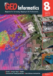
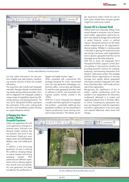
This shows a Mobile LiDAR dataset in 3D colored by Intensity.<br />
This shows a LiDAR dataset that has been RGB encoded in 2D and 3D.<br />
elegant and highly intuitive “apps.”<br />
When presented with conventional GIS<br />
package designed for niche, specialized<br />
users, this new generation disengages, productivity<br />
suffers, and projects get delayed.<br />
To meet this need, geospatial providers need<br />
to embrace a rebirth, and essentially reinvigorate<br />
systems initially created in the<br />
1990s.<br />
With this in mind, Intergraph has adopted<br />
a modern and fresh approach for its geospatial<br />
portfolio – essentially redefining how<br />
geospatial workflows can be streamlined to<br />
improve productivity, lower training costs,<br />
and increase utilization. The refined, yet simple,<br />
experience makes it faster for users to<br />
both create reliable data and gain greater<br />
insight from multi-source content.<br />
Dynamic GIS in a Dynamic World<br />
Global events are continually shifting. From<br />
natural disaster to economic crisis to international<br />
conflict, organizations need to be nimble<br />
to stay ahead of changes that could result<br />
in severe financial, social, or political<br />
impacts. Geospatial solutions are the fundamental<br />
underpinning for all organizations’<br />
decision-making. Whether it is tracking assets<br />
in the field or gaining full situational awareness<br />
during a hurricane, smart organizations<br />
look to dynamic geospatial tools that can be<br />
leveraged across the entire enterprise.<br />
With this in mind, the Intergraph <strong>2013</strong><br />
Geospatial Portfolio supports critical decision-making<br />
in time-sensitive situations by<br />
providing powerful solutions for creating,<br />
analyzing, and extracting information from<br />
dynamic, multi-source content. The complete<br />
portfolio allows organizations to securely<br />
manage and rapidly deliver geospatial<br />
information products integrated with other<br />
forms of business data – both inside and outside<br />
of the organization.<br />
Recognizing the significance of this in<br />
today’s rapidly transforming world has<br />
resulted in new expectations for information<br />
on-demand, delivered in a context and<br />
application-relevant form to the field, office,<br />
or online. Contemporary geospatial solutions<br />
are designed to meet this expectation<br />
and allow organizations to be more agile<br />
and respond effectively when faced with<br />
change.<br />
June <strong>2013</strong>