2013 - Geoinformatics
2013 - Geoinformatics
2013 - Geoinformatics

Create successful ePaper yourself
Turn your PDF publications into a flip-book with our unique Google optimized e-Paper software.
23<br />
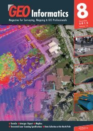
Composite of Kitimat Arm and LiDAR data with shaded relief<br />
McElhanney, which owns three Leica Geosystems LiDAR scanners<br />
and two Leica Geosystems ADS digital cameras, initiated the lineament<br />
mapping project using the Leica ALS60 and is upgrading to<br />
the more powerful 500 kHz ALS70-HP system.<br />
This LiDAR systems provide the minimum 2 points per square-meter<br />
(2 points per 2.4 square yards) density required to generate bareearth<br />
DEMs with the accuracy and resolution sufficient for revealing<br />
the narrow linear surface features. In the British Columbia pilot project,<br />
McElhanney operated the LiDAR at an altitude of 2500-3000<br />
meters above mean sea level to collect the data set. Standard processing<br />
removed the returns associated with vegetation to generate<br />
a bare-earth DEM with 10-cm (4 in) vertical and 30 to 50 cm (12 to<br />
20 in) horizontal accuracy.<br />
“The Leica Geosystems ALS LiDAR operates with a high pulse rate<br />
to ensure the vegetation is penetrated with a point density that is<br />
sufficient to find surface lineaments measuring just 50 centimeters<br />
(20 inches) in width,” said Koohzare. “And the high power of the<br />
unit means the dense point data can be captured at high aircraft<br />
speed, which saves time and money.”<br />
Ground Subsidence<br />
McElhanney devised its idea for ground subsidence monitoring in<br />
Saskatchewan where potash deposits are mined and used for fertilizer.<br />
Potash extraction poses a higher risk of ground subsidence than<br />
many other types of mining because the evaporate deposits are<br />
found in soft rock formations that are structurally less than ideal for<br />
tunneling. As a result, potash mines must be continually monitored<br />
for subsidence or sinking, of ground above and around the excavation<br />
site.<br />
“Subsidence above the mine gives advance warning that personnel<br />
inside may be at risk of a cave-in or collapse,” said Koohzare,<br />
adding that subsidence and uplift can cause problems for up to five<br />
kilometers in any direction from the mine site. In addition to dangers<br />
inside the mine, the ground movement can also sever pipelines, damage<br />
roads, and crack building foundations in the affected region.<br />
Monitoring subsidence around potash mines – and other mineral<br />
extraction projects – is typically carried out using traditional ground<br />
survey techniques, which are expensive and time consuming. Based<br />
on LiDAR operations in hundreds of projects, many involving energy<br />
June <strong>2013</strong>