2013 - Geoinformatics
2013 - Geoinformatics
2013 - Geoinformatics

You also want an ePaper? Increase the reach of your titles
YUMPU automatically turns print PDFs into web optimized ePapers that Google loves.
7<br />
Excelling in the era of analytics<br />
DigitalGlobe keeps a constant eye on the<br />
world to help customers gain an early<br />
insight into the business, military, environmental<br />
and political changes that impact<br />
people around the world. But moving forward,<br />
it is clear that the insight derived from<br />
imagery will become as important as the<br />
pixels themselves. The insight provided by<br />
imagery, geospatial and all source analysts<br />
can make a significant difference in evacuation<br />
planning, disaster response, recovery,<br />
and rebuilding in regions worldwide.<br />
DigitalGlobe plans to continue enhancing<br />
its analytical capabilities to excel in the<br />
increasingly important era of analytics.<br />
As a result of DigitalGlobe’s recent combination<br />
with GeoEye and its acquisition of<br />
Tomnod, a crowdsourced intelligence pioneer,<br />
DigitalGlobe is now a driving force<br />
in the analytics industry. Equipped with a<br />
more advanced satellite collection system<br />
and some of the world’s best geospatial<br />
production and analysis professionals,<br />
Digital Globe can provide timely insights<br />
and information about critical events worldwide.<br />
Using analytics to support disaster<br />
management<br />
DigitalGlobe has a long history of providing<br />
imagery for disasters and crises across<br />
the globe, ranging from war crimes in<br />
Sudan to the wildfire devastation in<br />
Colorado. Satellite images provide an effective<br />
way to gauge the damage from disasters<br />
through comparisons of before-duringand-after<br />
images that geospatial analysts<br />
can use to provide answers to the right people.<br />
In fact, DigitalGlobe’s FirstLook service,<br />
which monitors disasters and crises worldwide,<br />
leverages its satellite constellation<br />
and ground infrastructure to collect and<br />
deliver up-to-date imagery of an event to<br />
customers in as little as four hours.<br />
Before Hurricane Sandy hit the east coast<br />
last October, DigitalGlobe satellites captured<br />
images of the affected areas,<br />
enabling the employment of change detection<br />
to narrow in on the most damaged<br />
areas. After the storm hit, DigitalGlobe’s<br />
analysts quickly staged the before and after<br />
imagery within hours of collection so rescue<br />
workers and relief personnel could<br />
quickly understand the most affected areas<br />
and how to route first responders and relief<br />
supplies.<br />
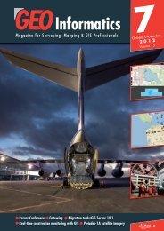
High Park Fire, Colorado from June 13, 2012.<br />
This image shows the fire’s west and northwest<br />
extents and areas where beetle kill is evident.<br />
In this image the burnt areas are dark blue and<br />
red is healthy vegetation, smoke from the fire is<br />
mostly white.<br />
June <strong>2013</strong>