You also want an ePaper? Increase the reach of your titles
YUMPU automatically turns print PDFs into web optimized ePapers that Google loves.
Licensed to max. Printed on 16 Feb 2008.<br />
NOTICE: PRINTED FROM AN EXPIRED REVISION. Disc 01-2008<br />
<strong>LOWW</strong>/VIE<br />
B<br />
C<br />
30 NOV 07<br />
10-9F<br />
A 321<br />
A<br />
C<br />
JEPPESEN<br />
JeppView 3.5.2.0<br />
VIENNA, AUSTRIA<br />
SCHWECHAT<br />
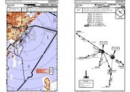
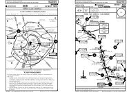
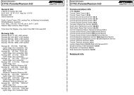
VISUAL DOCKING GUIDANCE SYSTEM (SAFEGATE) PIER WEST<br />
ROUTINE DOCKING MANOEUVRE<br />
JEPPESEN<br />
1. Check that the correct aircraft type is displayed.<br />
2. The "floating" arrows indicate that the system is activated.<br />
3. Follow lead-in line.<br />
4. When the two vertical closing rate fields turn yellow the aircraft is caught by the laser and<br />
being identified.<br />
5. Watch the red arrows in relation to the yellow centreline indicator for correct azimuth<br />
guidance.<br />
6. When the aircaft is 39'/12m from the stop position, the closing rate starts indication of<br />
distance to go by turning off one pair of LEDs for each 3'/1m the aircraft advances into<br />
the gate.<br />
7. When the correct stop position is reached, the display will show "STOP" and the azimuth field<br />
will turn red. All yellow closing rate LEDs will be switched off.<br />
8. When the aircraft is correctly parked "OK" will be displayed after a few seconds.<br />
9. After "CHOCK/ON" will be displayed for the next 3 minutes.<br />
EMERGENCY STOP: "STOP" with a red bar will appear on the display.<br />
BRIEFING STRIP TM<br />
Licensed to max. Printed on 16 Feb 2008.<br />
NOTICE: PRINTED FROM AN EXPIRED REVISION. Disc 01-2008<br />
<strong>LOWW</strong>/VIE<br />
SCHWECHAT<br />
D-ATIS Arrival 122.95<br />
112.2 113.0 115.5<br />
LOC<br />
OEW<br />
110.3 114^ 4932'<br />
48-10<br />
1654'<br />
2093'<br />
2155'<br />
Final<br />
Apch Crs<br />
1789'<br />
204^<br />
1634'<br />
11 JAN 08<br />
WIEN Radar (APP)<br />
GS<br />
D12.8 OEW<br />
1197'<br />
LO(R)-15<br />
JEPPESEN<br />
11-1<br />
WIEN Director<br />
ILS<br />
DA(H)<br />
(4357') 1765'(1190')<br />
MISSED APCH: Turn RIGHT to VOR, climb to 4000' 1 and hold.<br />
BALKED LANDING: As early as practicable turn RIGHT to heading 250^<br />
with MAX bank, to avoid penetration of rwy 16 and climb to 5000'.<br />
1191'<br />
JEPPESEN<br />
JeppView 3.5.2.0<br />
VIENNA, AUSTRIA<br />
ILS Y Rwy 11<br />
WIEN Tower<br />
Apt Elev 600'<br />
RWY 575'<br />
Alt Set: hPa Rwy Elev: 21 hPa Trans level: By ATC Trans alt: 5000'<br />
090^<br />
1138'<br />
*Ground<br />
118.77 128.2 124.55 129.05 119.8 126.55 119.4 123.8 121.6 121.77<br />
Terrain clearance has to be assured by pilot up to 2400'. If unable to comply inform ATC.<br />
1952'<br />
2129'<br />
MHA<br />
5000<br />
STEINHOF<br />
293 S T STEE<br />
114^<br />
1519'<br />
2116'<br />
D13.4<br />
1437'<br />
OEW<br />
2048'<br />
294^<br />
D12.8 OEW<br />
ABEAM<br />
1050'<br />
2280'<br />
2119'<br />
1187'<br />
ILS DME<br />
O E W<br />
1067'<br />
114^ 110.3 OEW<br />
1365'<br />
W 303 VIENNA<br />
OWO<br />
D3.6 OEW<br />
1181'<br />
250^hdg<br />
BALKED LANDING<br />
3200'<br />
5400'<br />
1 5000' in case of COM failure.<br />
315^<br />
MSA STE NDB<br />
Silmultaneous apch on<br />
rwy 16 may be executed.<br />
PROCEDURE USABLE<br />
DURING VMC ONLY.<br />
225^<br />
2500'<br />
1050'<br />
A: ALPHANUMERICAL<br />
Acft type<br />
WAIT/TEST<br />
ERROR<br />
ERR10<br />
GATE/BLOCK<br />
FORM OF DISPLAY<br />
WAIT/STOP<br />
ID FAIL/STOP<br />
SLOW/DOWN<br />
SBU/STOP<br />
STOP<br />
STOP followed by OK<br />
STOP/ABORT<br />
TOO FAR<br />
CHOCK/ON<br />
B: AZIMUTH GUIDANCE<br />
INDICATION FOR<br />
(Laser scanning technique) for use by the pilots occupying both the left and right seats.<br />
C: CLOSING RATE INFORMATION<br />
CHANGES: Chart reindexed.<br />
(preselected)<br />
Calibration procedure<br />
System error<br />
System error (communication error with system)<br />
Not allowed object within scanning range when system starts -<br />
stand not usable<br />
Not allowed object within scanning range - stop<br />
Identification failed - stop<br />
Taxiing speed too high<br />
Too far of centreline within last 10'/3m to stop position<br />
Emergency stop<br />
Correct stop position<br />
Docking is interrupted by gate operator<br />
Acft has overshot the stop position (more than 1m)<br />
(disappears after 3 min)<br />
| JEPPESEN SANDERSON, INC., 2002, 2007. ALL RIGHTS RESERVED.<br />
PANS OPS<br />
A<br />
B<br />
C<br />
D<br />
48-00<br />
2612'<br />
3173'<br />
2349'<br />
1 Min<br />
1664'<br />
1532'<br />
DS N U<br />
1916'<br />
SOLLENAU<br />
115.5 SNU<br />
DA(H)<br />
FULL<br />
1529'<br />
170^<br />
LO(R)-2<br />
1060'<br />
1761' 1453'<br />
1402'<br />
1493'<br />
LO(D)-26<br />
LO(R)-16<br />
MHA<br />
16-10 4000 16-30 16-40<br />
16-50<br />
LOC<br />
4940' GS<br />
Gnd speed-Kts 70 90 100 120 140 160<br />
HIALS<br />
ILS GS 3.10^ or<br />
LOC Descent Gradient<br />
MAP at LOM/D3.6 OEW<br />
.JAR-OPS.<br />
STRAIGHT-IN LANDING RWY11 .CEILING.REQUIRED.<br />
ILS<br />
LOC (GS out)<br />
2884'<br />
5000'<br />
D13.4<br />
OEW<br />
294^<br />
114^<br />
4000' SNU<br />
5.4% 390 501 557 668 779 891 PAPI<br />
115.5<br />
1765'(1190')<br />
ALS out<br />
2400'-<br />
RVR 800m<br />
2400'-<br />
RVR 1200m<br />
D12.8 OEW<br />
4932'<br />
MISSED APCH<br />
ABEAM STE NDB<br />
5000'<br />
0.6 9.2<br />
MDA(H)<br />
2400'- RVR1200m<br />
2400'- RVR 1400m<br />
2400'- RVR1800m<br />
CHANGES: Tower frequency. Missed approach. Note. Minimums.<br />
1770'<br />
LOM M<br />
D3.6 OEW<br />
GS 1765'<br />
(1195')<br />
ALS out<br />
2400'-<br />
RVR 1500m<br />
2400'-<br />
RVR 2000m<br />
3.4<br />
1027'<br />
TCH 54'<br />
RWY 11<br />
RT<br />
575'<br />
| JEPPESEN, 2007, 2008. ALL RIGHTS RESERVED.