
Create successful ePaper yourself
Turn your PDF publications into a flip-book with our unique Google optimized e-Paper software.
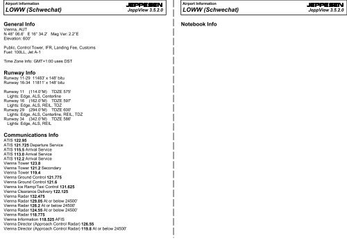
Airport Information<br />
<strong>LOWW</strong> (<strong>Schwechat</strong>)<br />
JEPPESEN<br />
JeppView 3.5.2.0<br />
Airport Information<br />
<strong>LOWW</strong> (<strong>Schwechat</strong>)<br />
JEPPESEN<br />
JeppView 3.5.2.0<br />
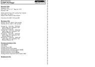
General Info<br />
Vienna, AUT<br />
N 48° 06.6' E 16° 34.2' Mag Var: 2.2°E<br />
Elevation: 600'<br />
Notebook Info<br />
Public, Control Tower, IFR, Landing Fee, Customs<br />
Fuel: 100LL, Jet A-1<br />
Time Zone Info: GMT+1:00 uses DST<br />
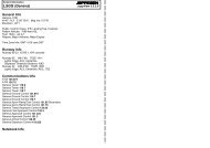
Runway Info<br />
Runway 11-29 11483' x 148' bitu<br />
Runway 16-34 11811' x 148' bitu<br />
Runway 11 (114.0°M) TDZE 575'<br />
Lights: Edge, ALS, Centerline<br />
Runway 16 (162.0°M) TDZE 597'<br />
Lights: Edge, ALS, REIL, TDZ<br />
Runway 29 (294.0°M) TDZE 600'<br />
Lights: Edge, ALS, Centerline, REIL, TDZ<br />
Runway 34 (342.0°M) TDZE 586'<br />
Lights: Edge, ALS, REIL<br />
Communications Info<br />
ATIS 122.95<br />
ATIS 121.725 Departure Service<br />
ATIS 115.5 Arrival Service<br />
ATIS 113.0 Arrival Service<br />
ATIS 112.2 Arrival Service<br />
Vienna Tower 123.8<br />
Vienna Tower 121.2 Secondary<br />
Vienna Tower 119.4<br />
Vienna Ground Control 121.775<br />
Vienna Ground Control 121.6<br />
Vienna Ice Ramp/Taxi Control 131.625<br />
Vienna Clearance Delivery 122.125<br />
Vienna Radar 132.475<br />
Vienna Radar 129.05 At or below 24500'<br />
Vienna Radar 128.2 At or below 24500'<br />
Vienna Radar 124.55 At or below 24500'<br />
Vienna Radar 118.775<br />
Vienna Information 118.525 AFIS<br />
Vienna Director (Approach Control Radar) 126.55<br />
Vienna Director (Approach Control Radar) 119.8 At or below 24500'
Licensed to max. Printed on 16 Feb 2008.<br />
NOTICE: PRINTED FROM AN EXPIRED REVISION. Disc 01-2008<br />
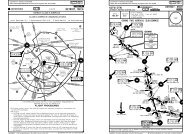
<strong>LOWW</strong>/VIE<br />
SCHWECHAT<br />
+JEPPESEN<br />
30 NOV 07 10-1P<br />
JEPPESEN<br />
JeppView 3.5.2.0<br />
VIENNA, AUSTRIA<br />
AIRPORT.BRIEFING<br />
1. GENERAL<br />
1.1. ATIS<br />
D-ATIS Arrival 122.95 122.2 113.0 115.5<br />
D-ATIS Departure 121.72<br />
1.2. NOISE ABATEMENT PROCEDURES<br />
According to the Austrian ordinance 'Zivilluftfahrzeug-Laermzulaessigkeitsverordnung<br />
ZLZV-2005' the following is applicable:<br />
- Approaches and departures to/from Austrian civil aerodromes are only permitted<br />
to be performed by subsonic jet ACFT if the produced noise does not exceed the<br />
noise limits specified in chapter 3 of ICAO Annex 16, Vol I.<br />
1.3. LOW VISIBILITY PROCEDURES (LVP)<br />
Low Visibility Procedures become effective in two stages in the following<br />
conditions:<br />
Stage 1:<br />
When TDZ RVR falls to 1200m or less and/or ceiling lowers to 300' or less, the<br />
following message will be passed to ACFT via RTF or ATIS: "Low Visibility<br />
Procedures stage 1 in operation". CAT II/III apchs are possible on request.<br />
The procedures for LVP stage 2 including protection of sensitive area are applied.<br />
Stage 2:<br />
When TDZ RVR falls to 600m or less and/or ceiling lowers to 200' or less, the<br />
following message will be passed to ACFT via RTF or ATIS: "Low Visibility<br />
Procedures CAT II/III stage 2 in operation".<br />
Arriving ACFT are vectored so as to ensure a localizer intercept at least 8 NM from<br />
THR. Only if instructed by ATC pilots shall report "RWY vacated" as soon as ACFT<br />
has left the yellow/green colour coded section of the exit TWY.<br />
1.4. RWY OPERATIONS<br />
HIGH INTENSITY RWY OPERATIONS (HIRO)<br />
The HIRO system is valid from 0600 - 2300 LT unless otherwise advised by ATC (e.g.<br />
via ATIS). The HIRO system ensures a maximum RWY capacity, minimizes "go<br />
arounds" and enables departures during single RWY operations and continuous<br />
inbound traffic.<br />
1.5. TAXI PROCEDURES<br />
Obstacle clearance distance from centerline of TWY L, to the southern edge of main<br />
apron West of TL35 is 139'/42.5m only. The obstacle clearance distance on TL35 is<br />
131'/40m on each side.<br />
Wait for marshaller before entering taxilane for all positions on GA Apron or Main<br />
Apron except pier parking positions.<br />
In order to meet the requirement for wing-tip clearance, follow strictly the yellow<br />
taxi guidance lines.<br />
Taxilanes G10 thru G70 MAX wingspan less than 79 '/24m.<br />
EX15 and TWY L West of EX14 MAX wingspan less than 171 '/52m.<br />
TWYs P, Q, TL31, TL32 and T33 MAX wingspan 118 '/36m.<br />
Between EX12 and EX13 MAX wingspan 200 '/61m.<br />
TL34 MAX wingspan 213 '/65m.<br />
Taxiing on apron North of TL20 prohibited.<br />
1.6. PARKING INFORMATION<br />
Stands 31 thru 35, 40 thru 42, 51, 52, 57 and 58 shall be reached without stopping,<br />
once the turn from TWY has been initiated.<br />
Whenever docking process has been interrupted, pilot has to inform ATC to start<br />
moving again.<br />
On stands 31 thru 59, A91 thru A97, B71 thru B74, F01 thru F37, H41 thru H45, H50<br />
and K41 thru K51 push-back required.<br />
1.7. OTHER INFORMATION<br />
RWY 11/29 grooved.<br />
RWY 16/34 grooved 66 '/20m on each side of centerline.<br />
Licensed to max. Printed on 16 Feb 2008.<br />
NOTICE: PRINTED FROM AN EXPIRED REVISION. Disc 01-2008<br />
<strong>LOWW</strong>/VIE<br />
SCHWECHAT<br />
+ JEPPESEN<br />
30 NOV 07 10-1P1<br />
JEPPESEN<br />
JeppView 3.5.2.0<br />
VIENNA, AUSTRIA<br />
AIRPORT.BRIEFING<br />
2. ARRIVAL<br />
2.1. SPEED RESTRICTIONS<br />
250 KT or cruising speed if lower at SLP.<br />
2.1.1. LOW DRAG - LOW POWER APPROACH<br />
Comply with any speed adjustments by ATC as promptly and as accurately as<br />
operationally possible. If unable to maintain an assigned speed due to<br />
meteorological or operational reasons advise ATC.<br />
If not otherwise advised, 250 KT has to be maintained below FL100. If the cruising<br />
speed is less than 250 KT, cruising speed has to be maintained.<br />
Latest 10 NM from THR, speed has to be reduced so as to reach 160 KT shortly before<br />
OM (4 NM from THR RWY 29). The approach shall be conducted in 'clean<br />
configuration' as long as possible.<br />
If ceiling at APT is below 500' and/or ground visibility is less than 2000m this<br />
procedure is recommended only.<br />
Pilots unable to comply with these speed assignments shall inform ATC accordingly.<br />
These speeds indicated above shall be maintained within a tolerance of plus/minus<br />
10 KT.<br />
2.2. NOISE ABATEMENT POCEDURES<br />
ACFT below FL150 will normally be cleared to achieve a continuous descent to the<br />
RWY in use.<br />
2.3. CAT II/III OPERATIONS<br />
RWYs 16 and 29 approved for CAT II/III operations, special aircrew and ACFT<br />
certification required.<br />
2.4. RUNWAY OPERATIONS<br />
2.4.1. HIGH INTENSITY RWY OPERATIONS (HIRO)<br />
Expeditious exit from the landing RWY allows ATC to separate ACFT with the<br />
appropriate separation minimum (radar separation 2.5 NM or separation minimum<br />
according wake vortex category) during final approach.<br />
To reduce the RWY occupancy time pilots should make use of the following<br />
procedure:<br />
- As a rule RWYs shall be vacated via rapid exit TWYs.<br />
- Whenever RWY conditions permit pilots should prepare their landing so as to<br />
vacate via the following exit TWYs or earlier:<br />
ACFT<br />
Category<br />
Heavy<br />
Medium<br />
(Jet)<br />
Medium<br />
(Turboprops)<br />
Light<br />
(Jet)<br />
Light<br />
TWY designator<br />
Distance<br />
RWY 11 RWY 16 RWY 29 RWY 34<br />
A4 B10 A9 B4<br />
7841'/2390m 6873'/2095m 7218'/2200m 7661'/2335m<br />
A6<br />
6102'/1860m<br />
A8<br />
3839'/1170m<br />
If unable to comply with the HIRO system advise ATC as soon as possible.<br />
B8<br />
5577'/1700m<br />
B6<br />
3986'/1215m<br />
A7<br />
5479'/1670m<br />
B7<br />
5348'/1630m<br />
A8 B6 A7 B7<br />
3839'/1170m 3986'/1215m 5479'/1670m 5348'/1630m<br />
A8 B6 A7 B7<br />
3839'/1170m 3986'/1215m 5479'/1670m 5348'/1630m<br />
A8 B3 A5 B9<br />
3839'/1170m 3035'/925m 3084'/940m 3937'/1200m<br />
CHANGES: Taxi procedures. Parking procedures.<br />
| JEPPESEN SANDERSON, INC., 2005, 2007. ALL RIGHTS RESERVED.<br />
CHANGES: None.<br />
| JEPPESEN SANDERSON, INC., 2005, 2007. ALL RIGHTS RESERVED.
Licensed to max. Printed on 16 Feb 2008.<br />
NOTICE: PRINTED FROM AN EXPIRED REVISION. Disc 01-2008<br />
<strong>LOWW</strong>/VIE<br />
SCHWECHAT<br />
+JEPPESEN<br />
30 NOV 07 10-1P2<br />
JEPPESEN<br />
JeppView 3.5.2.0<br />
VIENNA, AUSTRIA<br />
AIRPORT.BRIEFING<br />
2. ARRIVAL<br />
2.5. TAXI PROCEDURES<br />
2.5.1. GENERAL<br />
ACFT shall vacate the RWY after landing without delay if not otherwise instructed.<br />
Taxi clearance to apron or parking area will normally be issued by TWR when landing<br />
run is completed. If taxi clearance to apron or parking area has not been received at<br />
this time, ACFT shall vacate the RWY via the nearest TWY intersection and shall<br />
hold and wait on the TWY when entirely beyond the taxi holding position.<br />
2.5.2. BLOCKS OF PARKING POSITIONS 10 THRU 50<br />
Taxiing of ACFT within Taxilanes G10 to G70 permitted only for ACFT up to<br />
79'/24m.<br />
Follow-me guidance mandatory for all arriving ACFT.<br />
ACFT, which will be parked East of TL 31 have to be towed.<br />
Self taxiing, refuelling/ground handling not permitted within this area.<br />
2.6. OTHER INFORMATION<br />
2.6.1. TRANSPONDER PROCEDURES<br />
Arriving ACFT shall squawk Mode S until reaching final parking position.<br />
Activation of Mode S transponder means selecting: AUTO, ON, XPNDR, or the<br />
equivalent according specific installation. Do not switch OFF or STDBY.<br />
ACFT not equipped with Mode S shall squawk Mode A/C.<br />
3. DEPARTURE<br />
3.1. DE-ICING<br />
De-icing procedure available for ACFT on Main Apron and GA Apron:<br />
- Report the necessity for de-icing either your Ramp agent or VIENNA Ice on<br />
131.625.<br />
- ACFT on Main Apron without contracted de-icing ground staff shall forward<br />
fluid/mixture request to Ramp agent.<br />
ACFT on GA Apron shall forward fluid/mixture request to GAC-officer.<br />
- Report necessity for de-icing to Delivery when the ACFT is completely ready (doors<br />
closed, ready for start-up/push-back)<br />
- ACFT on de-icing position without contracted de-icing ground staff may contact<br />
VIENNA Ice on 131.625.<br />
ACFT taxiing to the de-icing position without following this procedure will not be<br />
accepted and sent back to a remote stand.<br />
Normally ATC will clear ACFT to the de-icing standby area (marshaller guidance to<br />
parking positions E48 thru E99 approaching from the South). If instructed by<br />
marshaller car to stop on the de-icing standby area, do not cut engines -<br />
intermediate stop only. Thereafter marshaller guidance to the de-icing positions<br />
(parking positions F41 thru F59) is provided.<br />
Licensed to max. Printed on 16 Feb 2008.<br />
NOTICE: PRINTED FROM AN EXPIRED REVISION. Disc 01-2008<br />
<strong>LOWW</strong>/VIE<br />
SCHWECHAT<br />
+ JEPPESEN<br />
30 NOV 07 10-1P3<br />
3.3. SPEED RESTRICTIONS<br />
MAX 250 KT below FL100 or as by ATC.<br />
3.4. NOISE ABATEMENT PROCEDURES<br />
The published SIDs are also noise abatement procedures.<br />
Strict adherence is compulsory within the limits ACFT performance.<br />
JEPPESEN<br />
JeppView 3.5.2.0<br />
VIENNA, AUSTRIA<br />
AIRPORT.BRIEFING<br />
3.5. RUNWAY OPERATIONS<br />
3.5.1. HIGH INTENSITY RWY OPERATIONS<br />
ATC will consider every ACFT at the holding point as able to commence line up and<br />
take-off roll immediately after clearance issued. Pilots not ready when reaching the<br />
holding point (no ACFT in front on the same TWY) shall advise ATC as early as<br />
possible. When cleared for take-off ATC will expect and has planned on seeing<br />
movement within 10 seconds (of take-off clearance being issued). Pilots unable to<br />
comply with this requirement shall notify ATC before entering the RWY. Wake<br />
vortex separation is applied by ATC in accordance with the published requirements.<br />
If more separation than the prescribed minima is requested, pilots shall notify ATC<br />
before entering the RWY.<br />
Pilots shall prepare and be ready to accept the following intersection take-off runs:<br />
ACFT<br />
Category<br />
Medium/<br />
Light<br />
3. DEPARTURE<br />
TWY designator<br />
TORA<br />
RWY 11 RWY 16 RWY 29 RWY 34<br />
A10 B4 A3 (West) B10<br />
9531'/2905m 7661'/2335m 9944'/3031m 6873'/2095m<br />
To increase RWY capacity and to comply with slot times, ATC may reorder departure<br />
sequence at any time.<br />
In addition intersections other than those prescribed above will be assigned.<br />
Pilots unable to accept the reduced take-off runs from the assigned or above<br />
mentioned intersections shall inform ATC in time.<br />
3.6. OTHER INFORMATION<br />
3.6.1. TRANSPONDER PROCEDURES<br />
Departing ACFT shall select the assigned transponder code and squawk Mode S at<br />
push-back request or at taxi request latest.<br />
Activation of Mode S transponder means selecting: AUTO, ON, XPNDR, or the<br />
equivalent according specific installation. Do not switch OFF or STDBY.<br />
ACFT not equipped with Mode S shall squawk Mode A/C.<br />
Chemical de-icing is limited to a width of 131 '/40m on RWYs and 49 '/15m on TWYs.<br />
3.2. START-UP, PUSH-BACK & TAXI PROCEDURES<br />
3.2.1. START-UP & PUSH-BACK<br />
If not otherwise instructed pilots of following ACFT are allowed to start one engine<br />
only during push-back/towing: B707, B747, B757, B767, B777, MD11, DC10, DC8,<br />
L1011, IL86, IL76, IL62, A300, A310, A330. Two engines: A340.<br />
3.2.2. TAXIING<br />
ACFT taxiing out from stands F41 and F44 must follow exactly the centerline<br />
marking in TL38.<br />
When taxiing out from stand F42 deviation to the West in TL38 is prohibited.<br />
CHANGES: Taxi procedures.<br />
| JEPPESEN SANDERSON, INC., 2005, 2007. ALL RIGHTS RESERVED.<br />
CHANGES: None.<br />
| JEPPESEN SANDERSON, INC., 2005, 2007. ALL RIGHTS RESERVED.
0 10 20 30 40 50<br />
10<br />
Licensed to max. Printed on 16 Feb 2008.<br />
NOTICE: PRINTED FROM AN EXPIRED REVISION. Disc 01-2008<br />
<strong>LOWW</strong>/VIE<br />
SCHWECHAT<br />
49-30<br />
49-00<br />
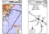
VIENNA Radar (APP)<br />
Alt Set: hPa<br />
Apt Elev<br />
128.2 118.77 124.55<br />
Trans level: By ATC Trans alt: 5000'<br />
600' 1. SQUAWK as instructed by ATC.<br />
129.05 132.47 2. MAX 250 KT below FL100.<br />
CZECH<br />
PRAGUE LKAA FIR<br />
VIENNA LOVV<br />
FIR<br />
AUSTRIA<br />
6000<br />
(5000)<br />
48-30<br />
47-30<br />
TULLN<br />
TUN VOR DME<br />
6000<br />
(5000)<br />
6211'<br />
7471'<br />
9000<br />
3278'<br />
(G)<br />
3609'<br />
8000<br />
FL110<br />
(9000)<br />
CHANGES: Reissue.<br />
6499'<br />
STOCKERAU<br />
STO VOR DME<br />
270^<br />
5643'<br />
8000<br />
D60<br />
9000<br />
7000<br />
5000<br />
3000<br />
CONTOUR<br />
INTERVALS<br />
300^<br />
2900<br />
5700<br />
8500<br />
3400<br />
240^<br />
3 AUG 07<br />
6811'<br />
4500<br />
5500<br />
D40<br />
5846'<br />
JEPPESEN<br />
10-1R<br />
LK(P)-9<br />
330^<br />
2600<br />
3200<br />
3402'<br />
Wiener<br />
Neustadt/<br />
Ost<br />
210^<br />
7000<br />
Voslau<br />
3700<br />
3071'<br />
1<br />
LK(P)-7<br />
D20<br />
2<br />
2900<br />
6000<br />
(5000)<br />
1<br />
2800<br />
2400<br />
Vienna<br />
3000<br />
STEINHOF<br />
STE NDB<br />
SOLLENAU<br />
SNU VOR DME<br />
180^<br />
D40<br />
D100<br />
D80<br />
D60<br />
0^<br />
2500<br />
D20<br />
2000<br />
3500<br />
2200<br />
BRUCK<br />
BRK NDB<br />
2500<br />
BUDAPEST<br />
LHCC FIR<br />
CZECH<br />
PRAGUE<br />
LKAA FIR<br />
HUNGARY<br />
JEPPESEN<br />
JeppView 3.5.2.0<br />
VIENNA, AUSTRIA<br />
.RADAR.MINIMUM.ALTITUDES.<br />
BRATISLAVA<br />
LZBB FIR (G)<br />
SLOVAKIA<br />
D20<br />
2000<br />
15-30 16-00 16-30 17-00<br />
2<br />
(F/G)<br />
3090'<br />
030^<br />
WAGRAM<br />
WGM<br />
VOR DME<br />
FISCHAMEND<br />
FMD<br />
VOR DME<br />
HUNGARY<br />
150^<br />
Bratislava<br />
BUDAPEST<br />
LHCC FIR<br />
(F/G)<br />
D40<br />
| JEPPESEN SANDERSON, INC., 2007. ALL RIGHTS RESERVED.<br />
Licensed to max. Printed on 16 Feb 2008.<br />
NOTICE: PRINTED FROM AN EXPIRED REVISION. Disc 01-2008<br />
COMMS<br />
LOST<br />
LOST COMMS LOST COMMS LOST COMMS LOST COMMS LOST COMMS LOST COMMS<br />
If clearance limit is reached before further instructions have been<br />
received, a holding procedure shall be carried out at the last<br />
cleared and acknowledged level. In case no communication can be<br />
established within 5 minutes after entering the holding, execute<br />
LOST COMMS LOST COMMS LOST COMMS LOST COMMS LOST COMMS LOST COMMS<br />
JEPPESEN<br />
JeppView 3.5.2.0<br />
JEPPESEN<br />
<strong>LOWW</strong>/VIE VIENNA, AUSTRIA<br />
SCHWECHAT<br />
4 JAN 08 10-2 .Eff.17.Jan.<br />
.STAR.<br />
D-ATIS<br />
Apt Elev Alt Set: hPa<br />
122.95 112.2 113.0 115.5<br />
Trans level: By ATC<br />
600' Trans alt: 5000'<br />
1. Non-RNAV aircraft expect radar vectors to final approach. 2. GPS/FMS<br />
aircraft expect GPS/FMS RNAV-Transition to final approach (refer to charts<br />
10-2F to 10-2J). 3. For noise abatement reasons the approach shall be conducted<br />
in "clean configuration" as long as possible.<br />
ASTUT SEVEN WHISKEY (ASTUT 7W) [ASTU7W]<br />
LEDVA ONE WHISKEY (LEDVA 1W) [LEDV1W]<br />
MIKOV SIX WHISKEY (MIKOV 6W) [MIKO6W]<br />
RWYS 11, 16, 29, 34 ARRIVALS<br />
SLP<br />
ASTUT<br />
N48 45.8 E016 02.9<br />
NOT TO SCALE<br />
CHANGES: None.<br />
At or below<br />
FL210<br />
111^<br />
FROM NORTH<br />
STARs crossing through<br />
Airspace "Class E"<br />
up to FL125<br />
28<br />
6000<br />
ASTUT 7W<br />
WAGRAM<br />
112.2 WGM<br />
N48 19.4 E016 29.5<br />
SLP<br />
MIKOV 6W<br />
MABOD<br />
N48 34.5 E016 41.4<br />
MIKOV<br />
N48 47.1 E016 37.3<br />
13<br />
6000<br />
165^<br />
10<br />
5000<br />
Speed Limit Point<br />
200^<br />
Communication Failure Procedure (refer to chart 10-2E).<br />
LEDVA 1W<br />
090^<br />
SLP<br />
LEDVA<br />
N48 43.7 E016 47.4<br />
At or below<br />
FL160<br />
HOLDING<br />
OVER MABOD<br />
LOST COMMS<br />
3200'<br />
3800'<br />
180^<br />
360^<br />
2900'<br />
MSA<br />
WGM VOR<br />
| JEPPESEN, 2003, 2007. ALL RIGHTS RESERVED.<br />
349^<br />
169^<br />
5000
Licensed to max. Printed on 16 Feb 2008.<br />
NOTICE: PRINTED FROM AN EXPIRED REVISION. Disc 01-2008<br />
<strong>LOWW</strong>/VIE<br />
JEPPESEN<br />
SCHWECHAT<br />
4 JAN 08 10-2A .Eff.17.Jan.<br />
D-ATIS<br />
Apt Elev Alt Set: hPa<br />
122.95 112.2 113.0 115.5<br />
Trans level: By ATC<br />
600' Trans alt: 5000'<br />
1. Non-RNAV aircraft expect radar vectors to final approach. 2. GPS/FMS<br />
aircraft expect GPS/FMS RNAV-Transition to final approach (refer to charts<br />
10-2F to 10-2N). 3. For noise abatement reasons the approach shall be conducted<br />
in "clean configuration" as long as possible.<br />
GIGOR ONE WHISKEY (GIGOR 1W) [GIGO1W]<br />
REKLU ONE WHISKEY (REKLU 1W) [REKL1W]<br />
TOVKA TWO WHISKEY (TOVKA 2W) [TOVK2W]<br />
RWYS 11, 16, 29, 34 ARRIVALS<br />
WAGRAM<br />
112.2 WGM<br />
N48 19.4 E016 29.5<br />
NOT TO SCALE<br />
COMMS<br />
LOST<br />
MABOD<br />
N48 34.5 E016 41.4<br />
349^<br />
WW44~<br />
N48 21.0<br />
E016 43.0<br />
WW4~~<br />
N48 16.8 E016 51.0<br />
169^<br />
5000<br />
FROM EAST<br />
14<br />
5000<br />
353^<br />
5000<br />
10<br />
5000<br />
REKLU 1W<br />
4<br />
5000<br />
TOVKA<br />
2W<br />
278^<br />
PESAT<br />
N47 42.9 E017 03.2<br />
LOST COMMS LOST COMMS LOST COMMS LOST COMMS LOST COMMS LOST COMMS<br />
If clearance limit is reached before further instructions have been<br />
received, a holding procedure shall be carried out at the last<br />
cleared and acknowledged level. In case no communication can be<br />
established within 5 minutes after entering the holding, execute<br />
Communication Failure Procedure (refer to chart 10-2E).<br />
7<br />
306^<br />
408 BRUCK<br />
BRK<br />
N48 03.8 E016 43.0<br />
SLP<br />
262<br />
REKLU<br />
N48 35.3 E016 56.3<br />
At FL180<br />
LOST COMMS LOST COMMS LOST COMMS LOST COMMS LOST COMMS LOST COMMS<br />
SLP<br />
6000<br />
090^<br />
Speed Limit Point<br />
JEPPESEN<br />
JeppView 3.5.2.0<br />
VIENNA, AUSTRIA<br />
STARs crossing through<br />
Airspace "Class E"<br />
up to FL125<br />
SLP<br />
TOVKA<br />
N48 16.0 E016 57.1<br />
270^<br />
At or below<br />
FL160<br />
GIGOR<br />
N47 45.6 E017 40.6<br />
25<br />
6000<br />
GIGOR 1W<br />
261^<br />
LOST COMMS<br />
SLP<br />
At or below<br />
FL160<br />
3200'<br />
360^<br />
MSA<br />
BRK NDB<br />
.STAR.<br />
090^ 270^<br />
4000' 2500'<br />
090^<br />
3200'<br />
3800'<br />
180^<br />
360^<br />
2900'<br />
MSA<br />
WGM VOR<br />
Licensed to max. Printed on 16 Feb 2008.<br />
NOTICE: PRINTED FROM AN EXPIRED REVISION. Disc 01-2008<br />
<strong>LOWW</strong>/VIE<br />
SCHWECHAT<br />
21 SEP 07 10-2B<br />
D-ATIS<br />
Apt Elev Alt Set: hPa<br />
122.95 112.2 113.0 115.5<br />
Trans level: By ATC<br />
600' Trans alt: 5000'<br />
1. Non-RNAV aircraft expect radar vectors to final approach. 2. GPS/FMS<br />
aircraft expect GPS/FMS RNAV-Transition to final approach (refer to charts<br />
10-2K to 10-2N). 3. For noise abatement reasons the approach shall be conducted<br />
in "clean configuration" as long as possible.<br />
GLEICHENBERG FIVE WHISKEY (GBG 5W)<br />
GRAZ SIX WHISKEY (GRZ 6W)<br />
XANUT ONE WHISKEY (XANUT 1W) [XANU1W]<br />
RWYS 11, 16, 29, 34 ARRIVALS<br />
LOST COMMS LOST COMMS LOST COMMS LOST COMMS<br />
If clearance limit is reached before further<br />
instructions have been received, a holding<br />
procedure shall be carried out at the last<br />
cleared and acknowledged level.<br />
In case no communication can be established<br />
within 5 minutes after entering the holding,<br />
execute Communication Failure Procedure<br />
(refer to chart 10-2E).<br />
LOST COMMS LOST COMMS LOST COMMS LOST COMMS<br />
GRAZ<br />
116.2 GRZ<br />
D<br />
N46 57.3 E015 27.0<br />
HOLDING<br />
OVER XANUT<br />
057^<br />
STARs crossing through<br />
Airspace "Class E"<br />
up to FL125<br />
FL130<br />
SLP<br />
237^<br />
Speed Limit Point<br />
FROM SOUTH<br />
061^<br />
JEPPESEN<br />
LOST COMMS LOST<br />
WW202<br />
N47 14.6 E015 58.4<br />
21<br />
8000<br />
GRZ 6W<br />
016^<br />
7<br />
8<br />
8000<br />
BALAD<br />
N47 46.0 E016 14.1<br />
8<br />
8000<br />
8<br />
8000<br />
8000<br />
XANUT<br />
N47 07.0 E015 54.7<br />
WW201<br />
N46 59.4 E015 51.1<br />
GBG<br />
5W<br />
GLEICHENBERG<br />
GBG 426 N46 53.2 E015 48.0<br />
035^<br />
GBG 5W<br />
GRZ 6W<br />
8000<br />
25<br />
8000<br />
D<br />
JEPPESEN<br />
JeppView 3.5.2.0<br />
VIENNA, AUSTRIA<br />
SNU<br />
SOLLENAU<br />
115.5 SNU<br />
N47 52.5 E016 17.3<br />
XANUT 1W<br />
215^<br />
090^<br />
SLP<br />
NIGSI<br />
N47 22.2 E016 02.2<br />
At or below<br />
FL180<br />
5400'<br />
180^<br />
8400'<br />
NOT TO SCALE<br />
MSA<br />
SNU VOR<br />
.STAR.<br />
3300'<br />
315^<br />
CHANGES: STAR EKLUS replaced by REKLU.<br />
| JEPPESEN, 2003, 2008. ALL RIGHTS RESERVED.<br />
CHANGES: Crossing at NIGSI.<br />
| JEPPESEN SANDERSON, INC., 2003, 2007. ALL RIGHTS RESERVED.
Licensed to max. Printed on 16 Feb 2008.<br />
NOTICE: PRINTED FROM AN EXPIRED REVISION. Disc 01-2008<br />
<strong>LOWW</strong>/VIE<br />
SCHWECHAT<br />
21 SEP 07 10-2C<br />
D-ATIS<br />
Apt Elev Alt Set: hPa<br />
122.95 112.2 113.0 115.5<br />
Trans level: By ATC<br />
600' Trans alt: 5000'<br />
1. Non-RNAV aircraft expect radar vectors to final approach. 2. GPS/FMS<br />
aircraft expect GPS/FMS RNAV-Transition to final approach (refer to charts<br />
10-2K to 10-2N). 3. For noise abatement reasons the approach shall be conducted<br />
in "clean configuration" as long as possible.<br />
GAMLI FOUR WHISKEY (GAMLI 4W) [GAML4W]<br />
NIMDU ONE WHISKEY (NIMDU 1W) [NIMD1W]<br />
RWYS 11, 16, 29, 34 ARRIVALS<br />
GAMLI<br />
N47 54.4<br />
E014 46.7<br />
089^ 9000<br />
GAMLI 4W<br />
NIMDU<br />
N47 10.3 E014 47.0<br />
092^<br />
SLP<br />
SLP<br />
BARUG<br />
N47 53.8 E015 21.3<br />
At or below<br />
FL180<br />
23 5<br />
FL130 9000<br />
NOT TO SCALE<br />
STARs crossing through<br />
Airspace "Class E"<br />
up to FL125<br />
269^<br />
Speed Limit Point<br />
46<br />
15000<br />
NIMDU 1W<br />
FROM WEST<br />
WW450<br />
N47 53.7 E015 28.9<br />
102^<br />
LOST COMMS LO<br />
JEPPESEN<br />
LOST<br />
31<br />
9000<br />
WW202<br />
N47 14.6 E015 58.4<br />
057^<br />
8<br />
FL130<br />
8<br />
8000<br />
8000<br />
035^<br />
8000<br />
25<br />
8000<br />
XANUT<br />
N47 07.0 E015 54.7<br />
237^<br />
LOST LOST COMMS LOST COMMS<br />
JEPPESEN<br />
JeppView 3.5.2.0<br />
VIENNA, AUSTRIA<br />
SNU<br />
SOLLENAU<br />
115.5 SNU<br />
N47 52.5 E016 17.3<br />
BALAD<br />
N47 46.0 E016 14.1<br />
SLP<br />
NIGSI<br />
N47 22.2 E016 02.2<br />
LOST COMMS LOST COMMS LOST COMMS LOST COMMS<br />
If clearance limit is reached before further<br />
instructions have been received, a holding<br />
procedure shall be carried out at the last<br />
cleared and acknowledged level.<br />
In case no communication can be established<br />
within 5 minutes after entering the holding,<br />
execute Communication Failure Procedure<br />
(refer to chart 10-2E).<br />
D<br />
215^<br />
090^<br />
5400'<br />
At or below<br />
FL180<br />
180^<br />
8400'<br />
LOST<br />
LOST COMMS COMMS<br />
MSA<br />
SNU VOR<br />
LOST COMMS LO<br />
.STAR.<br />
3300'<br />
315^<br />
Licensed to max. Printed on 16 Feb 2008.<br />
NOTICE: PRINTED FROM AN EXPIRED REVISION. Disc 01-2008<br />
<strong>LOWW</strong>/VIE<br />
SCHWECHAT<br />
122.95 112.2 113.0 115.5<br />
LANUX THREE WHISKEY (LANUX 3W) [LANU3W]<br />
LINZ SIX WHISKEY (LNZ 6W)<br />
MASUR ONE WHISKEY (MASUR 1W) [MASU1W]<br />
VENEN ONE WHISKEY (VENEN 1W) [VENE1W]<br />
RWYS 11, 16, 29, 34 ARRIVALS<br />
SLP<br />
LANUX<br />
N48 53.3 E015 36.9<br />
10-2D<br />
Apt Elev<br />
600'<br />
MASUR<br />
N48 31.2<br />
E015 26.4<br />
WW190 WW191<br />
N48 33.3 N48 32.7 WW192<br />
E014 46.0 E014 59.4 N48 31.9<br />
E015 12.9<br />
VENEN<br />
N48 34.0 E014 32.5<br />
NERDU<br />
N48 28.9 E016 06.0<br />
SLP<br />
TEMTA<br />
N48 30.5 E015 39.8<br />
LOST COMMS LOST COMMS LOST COMMS LOST COMMS<br />
JEPPESEN<br />
JeppView 3.5.2.0<br />
VIENNA, AUSTRIA<br />
1. Non-RNAV aircraft expect radar vectors to final approach. 2. GPS/FMS aircraft expect<br />
GPS/FMS RNAV-Transition to final approach (refer to charts 10-2F to 10-2J). 3. For noise<br />
abatement reasons the approach shall be conducted in "clean configuration" as long as possible.<br />
180^<br />
225^<br />
STARs crossing through<br />
Airspace "Class E"<br />
up to FL125<br />
3200'<br />
3200'<br />
090^<br />
090^<br />
SLP Speed Limit Point<br />
2900'<br />
2500'<br />
3800'<br />
5400'<br />
360^<br />
315^<br />
MSA<br />
WGM VOR<br />
MSA<br />
STE NDB<br />
D-ATIS<br />
At or below<br />
FL130<br />
139^<br />
21 SEP 07<br />
FROM NORTHWEST<br />
NOT TO SCALE<br />
31<br />
JEPPESEN<br />
6000<br />
LANUX 3W<br />
092^<br />
9<br />
104^<br />
6000 6000 6000<br />
9 9 9 9 17<br />
Alt Set: hPa<br />
Trans level: By ATC Trans alt: 5000'<br />
6000<br />
6000<br />
5000<br />
VENEN<br />
1W<br />
LNZ 6W<br />
MASUR<br />
1W<br />
VENEN 1W<br />
272^<br />
FL130<br />
284^<br />
56<br />
6000<br />
WAGRAM<br />
112.2 WGM<br />
N48 19.4 E016 29.5<br />
LNZ 6W<br />
At or below<br />
FL180<br />
069^<br />
LOST COMMS<br />
LOST COMMS LOST<br />
.STAR.<br />
STEINHOF<br />
293 STE<br />
N48 12.6 E016 14.8<br />
LINZ<br />
LNZ 116.6 D<br />
N48 13.8 E014 06.2<br />
LOST<br />
If clearance limit is reached before further<br />
instructions have been received, a holding<br />
procedure shall be carried out at the last<br />
cleared and acknowledged level.<br />
In case no communication can be established<br />
within 5 minutes after entering the holding,<br />
execute Communication Failure Procedure<br />
(refer to chart 10-2E).<br />
CHANGES: Crossings at BARUG & NIGSI.<br />
| JEPPESEN SANDERSON, INC., 2003, 2007. ALL RIGHTS RESERVED.<br />
CHANGES: Crossings at LANUX & TEMTA.<br />
| JEPPESEN SANDERSON, INC., 2003, 2007. ALL RIGHTS RESERVED.
Licensed to max. Printed on 16 Feb 2008.<br />
NOTICE: PRINTED FROM AN EXPIRED REVISION. Disc 01-2008<br />
<strong>LOWW</strong>/VIE<br />
SCHWECHAT<br />
122.95 112.2 113.0 115.5<br />
Alt Set: hPa<br />
Trans level: By ATC Trans alt: 5000'<br />
104^<br />
STE<br />
STEINHOF<br />
293 STE<br />
N48 12.6 E016 14.8<br />
D<br />
5000<br />
BALAD<br />
N47 46.0 E016 14.1<br />
NERDU<br />
N48 28.9 E016 06.0<br />
118^<br />
SNU<br />
SOLLENAU<br />
115.5 SNU<br />
N47 52.5 E016 17.3<br />
COMMUNICATION<br />
FAILURE PROCEDURE<br />
STARs crossing through<br />
Airspace "Class E"<br />
up to FL125<br />
284^<br />
114^<br />
035^<br />
R196^<br />
18<br />
016^<br />
7<br />
D-ATIS<br />
353^<br />
20<br />
12<br />
052^<br />
R054^<br />
R298^<br />
R232^<br />
R125^<br />
147^<br />
21<br />
17<br />
10-2E<br />
18<br />
205^<br />
Apt Elev<br />
600'<br />
MABOD<br />
N48 34.5 E016 41.4<br />
WAGRAM<br />
112.2 WGM<br />
N48 19.4 E016 29.5<br />
234^<br />
25<br />
PESAT<br />
N47 42.9 E017 03.2<br />
JEPPESEN<br />
JeppView 3.5.2.0<br />
VIENNA, AUSTRIA<br />
COMMUNICATION FAILURE ROUTING<br />
In case the runway in use is known proceed as depicted on chart clockwise to the relevant approach<br />
fix and maintain last cleared and acknowledged level. Start descent over approach fix<br />
and execute approach procedure.<br />
If the runway in use is not known proceed as depicted on chart to BRK and maintain last<br />
cleared and acknowledged level. Start descent over BRK and execute approach to runway 29.<br />
CHANGES: None.<br />
5000<br />
294^<br />
8000<br />
215^<br />
170^<br />
4000<br />
350^<br />
162^<br />
21 SEP 07<br />
5000<br />
342^<br />
JEPPESEN<br />
349^<br />
169^<br />
5000<br />
114^<br />
3200'<br />
090^ 270^<br />
4000' 2500'<br />
090^<br />
294^<br />
3000<br />
360^<br />
MSA<br />
BRK NDB<br />
3200'<br />
5400'<br />
315^<br />
MSA<br />
STE NDB<br />
2500'<br />
324^<br />
225^<br />
408 BRUCK<br />
BRK<br />
N48 03.8 E016 43.0<br />
090^<br />
6000<br />
090^<br />
090^<br />
5400'<br />
180^<br />
8400'<br />
MSA<br />
SNU VOR<br />
3200'<br />
3800'<br />
180^<br />
360^<br />
.STAR.<br />
3300'<br />
| JEPPESEN SANDERSON, INC., 2003, 2006. ALL RIGHTS RESERVED.<br />
315^<br />
2900'<br />
MSA<br />
WGM VOR<br />
NOT TO SCALE<br />
270^<br />
Licensed to max. Printed on 16 Feb 2008.<br />
NOTICE: PRINTED FROM AN EXPIRED REVISION. Disc 01-2008<br />
<strong>LOWW</strong>/VIE<br />
SCHWECHAT 20 JUL 07 10-2F<br />
D-ATIS<br />
122.95<br />
112.2<br />
113.0<br />
115.5<br />
Apt Elev<br />
600'<br />
WW853<br />
N48 22.8 E016 01.6<br />
At or above<br />
5000'<br />
WW813<br />
N48 18.3 E015 58.4<br />
At or above<br />
5000'<br />
Alt Set: hPa Trans level: By ATC Trans alt: 5000'<br />
1. Expect vectors for base/final when on downwind<br />
transition. 2.Expect direct routings/shortcuts by ATC<br />
whenever possible (especially during off-peak hours).<br />
3. Expect clearance for the IAP (normally ILS-APP)<br />
well before reaching WW811. In case no clearance<br />
was received perform an IAP. 4. If unable to follow<br />
transition advise ATC immediately.<br />
WW812<br />
N48 16.1 E016 05.1<br />
NERDU<br />
N48 28.9 E016 06.0<br />
203^<br />
5<br />
At or above<br />
5000'<br />
113^<br />
At or above<br />
6000'<br />
5 5<br />
098^ NERDU 1K<br />
WW811<br />
N48 13.9 E016 11.8<br />
LOST COMMS LOST COMMS LOST COMMS LOST COMMS LOST COMMS<br />
After reception of a Transition Clearance continue<br />
flight in accordance with the lateral and vertical<br />
description of the procedure with subsequent<br />
final approach of a conventional STAR procedure.<br />
After reception of a clearance direct to a waypoint<br />
continue flight in accordance with cleared waypoint,<br />
follow transition with subsequent final approach of<br />
a conventional STAR procedure.<br />
LOST COMMS LOST COMMS LOST COMMS LOST COMMS LOST COMMS<br />
CHANGES: Clearance phraseology.<br />
JEPPESEN<br />
10<br />
293^<br />
At or above<br />
5000'<br />
13.9<br />
.Eff.2.Aug.<br />
MABOD 1K [MAB1K], NERDU 1K [NER1K]<br />
RWY 11 RNAV TRANSITIONS<br />
NOT TO SCALE<br />
104^<br />
FROM NORTH<br />
5000<br />
284^<br />
COMMS<br />
LOST COMMS<br />
MABOD<br />
N48 34.5 E016 41.4<br />
WW818<br />
N48 26.4 E016 26.5<br />
At or above<br />
5000'<br />
9.6<br />
162^<br />
WW852<br />
N48 18.4 E016 15.1<br />
7.4<br />
262^<br />
At or above<br />
5000'<br />
JEPPESEN<br />
JeppView 3.5.2.0<br />
VIENNA, AUSTRIA<br />
.RNAV.TRANSITION.<br />
At or above<br />
6000'<br />
17.2<br />
4900' 2700'<br />
MABOD 1K<br />
205^<br />
WW851<br />
N48 19.3 E016 29.4<br />
At or above<br />
5000'<br />
TRANSITIONS crossing<br />
through Airspace<br />
"Class E" up to FL125<br />
CLEARANCE PHRASEOLOGY<br />
1. "Cleared xxx Transition": Authorization to fly the lateral GPS/FMS-route. Altitude<br />
assignments will be issued by ATC. (TERRAIN CLEARANCE ASSURED BY ATC)<br />
2. "Cleared xxx Transition and Profile": Authorization to fly the GPS/FMS-route as<br />
published, including the vertical constraints depicted on the procedure.<br />
3. "Cleared direct Waypoint xxx": Authorization to fly from the present position direct<br />
to a waypoint and to continue thereafter on the GPS/FMS-route to the runway in use.<br />
Altitude assignments will be issued by ATC. (TERRAIN CLEARANCE ASSURED BY ATC)<br />
110^<br />
DESCENT PLANNING<br />
Expect base turn normally<br />
abeam 10-15NM final.<br />
3400'<br />
MSA<br />
ARP<br />
TRANSITION<br />
ROUTING<br />
MABOD 1K MABOD (6000'+) - WW851 (5000'+) - WW852 (5000'+) - WW853 (5000'+) -<br />
WW813 (5000'+) - WW812 (5000'+) - WW811 (5000'+).<br />
NERDU 1K NERDU (6000'+) - WW818 (5000'+) - WW851 (5000'+) - WW852 (5000'+) -<br />
WW853 (5000'+) - WW813 (5000'+) - WW812 (5000'+) - WW811 (5000'+).<br />
270^<br />
| JEPPESEN SANDERSON, INC., 2003, 2007. ALL RIGHTS RESERVED.<br />
349^<br />
169^<br />
5000<br />
350^
Licensed to max. Printed on 16 Feb 2008.<br />
NOTICE: PRINTED FROM AN EXPIRED REVISION. Disc 01-2008<br />
<strong>LOWW</strong>/VIE<br />
SCHWECHAT 20 JUL 07 10-2G<br />
D-ATIS<br />
122.95<br />
112.2<br />
113.0<br />
115.5<br />
NERDU<br />
N48 28.9 E016 06.0<br />
At or above<br />
6000'<br />
104^<br />
Apt Elev<br />
600'<br />
154^<br />
WW871<br />
N48 18.6 E016 12.7<br />
At or above<br />
5000'<br />
NERDU 1L<br />
Alt Set: hPa Trans level: By ATC Trans alt: 5000'<br />
1. Expect vectors for base/final when on downwind<br />
transition. 2. Expect direct routings/shortcuts by ATC<br />
whenever possible (especially during off-peak hours).<br />
3. Expect clearance for the IAP (normally ILS-APP)<br />
well before reaching WW818. In case no clearance<br />
was received perform an IAP. 4. If unable to follow<br />
transition advise ATC immediately.<br />
WW895<br />
N48 29.9<br />
E016 17.3<br />
At or above<br />
5000'<br />
11.2<br />
WW819<br />
N48 31.2 E016 24.5<br />
WW896<br />
N48 20.3 E016 21.4<br />
WW818<br />
N48 26.4<br />
E016 26.5<br />
LOST COMMS LOST COMMS LOST COMMS LOST COMMS LOST COMMS<br />
After reception of a Transition Clearance continue<br />
flight in accordance with the lateral and vertical<br />
description of the procedure with subsequent<br />
final approach of a conventional STAR procedure.<br />
After reception of a clearance direct to a waypoint<br />
continue flight in accordance with cleared waypoint,<br />
follow transition with subsequent final approach of<br />
a conventional STAR procedure.<br />
LOST COMMS LOST COMMS LOST COMMS LOST COMMS LOST COMMS<br />
6<br />
071^<br />
At or above<br />
5000'<br />
10<br />
5<br />
071^161^<br />
341^<br />
At or above<br />
5000'<br />
5<br />
WW880<br />
N48 32.6 E016 31.7<br />
5<br />
At or above<br />
5000'<br />
251^<br />
At or<br />
above<br />
5000'<br />
.Eff.2.Aug.<br />
COMMS<br />
LOST COMMS<br />
10<br />
MABOD<br />
2L<br />
5 5<br />
342^<br />
169^<br />
162^<br />
5.1<br />
6<br />
WW884<br />
N48 13.4 E016 39.9<br />
JEPPESEN<br />
JeppView 3.5.2.0<br />
VIENNA, AUSTRIA<br />
.RNAV.TRANSITION.<br />
15<br />
252^<br />
At or above<br />
6000'<br />
MABOD<br />
N48 34.5 E016 41.4<br />
At or above<br />
6000'<br />
WW874<br />
N48 29.4 E016 42.5<br />
At or above<br />
6000'<br />
WW882<br />
N48 23.0 E016 35.8<br />
At or above<br />
5000'<br />
WW770<br />
N48 18.7 E016 37.8<br />
At or above<br />
5000'<br />
WW875<br />
N48 15.0<br />
E016 48.5<br />
At or above<br />
6000'<br />
TRANSITIONS crossing<br />
through Airspace<br />
"Class E" up to FL125<br />
CLEARANCE PHRASEOLOGY<br />
1. "Cleared xxx Transition": Authorization to fly the lateral GPS/FMS-route. Altitude<br />
assignments will be issued by ATC. (TERRAIN CLEARANCE ASSURED BY ATC)<br />
2. "Cleared xxx Transition and Profile": Authorization to fly the GPS/FMS-route as<br />
published, including the vertical constraints depicted on the procedure.<br />
3. "Cleared direct Waypoint xxx": Authorization to fly from the present position direct<br />
to a waypoint and to continue thereafter on the GPS/FMS-route to the runway in use.<br />
Altitude assignments will be issued by ATC. (TERRAIN CLEARANCE ASSURED BY ATC)<br />
CHANGES: Clearance phraseology.<br />
JEPPESEN<br />
MABOD 2L [MAB2L] , NERDU 1L [NER1L]<br />
RWY 16 RNAV TRANSITIONS<br />
FROM NORTH<br />
5000<br />
284^<br />
NOT TO SCALE<br />
110^<br />
DESCENT PLANNING<br />
Expect base turn normally<br />
abeam 10-15NM final.<br />
3400'<br />
4900' 2700'<br />
MSA<br />
ARP<br />
TRANSITION<br />
ROUTING<br />
MABOD 2L MABOD (6000'+) - WW874 (6000'+) - WW875 (6000'+) - WW884 (6000'+) -<br />
WW770 (5000'+) - WW882 (5000'+) - WW880 (5000'+) - WW819 (5000'+) -<br />
WW818 (5000'+).<br />
NERDU 1L NERDU (6000'+) - WW871 (5000'+) - WW896 (5000'+) - WW895 (5000'+) -<br />
WW819 (5000'+) - WW818 (5000'+).<br />
349^<br />
5000<br />
169^<br />
270^<br />
| JEPPESEN SANDERSON, INC., 2003, 2007. ALL RIGHTS RESERVED.<br />
350^<br />
Licensed to max. Printed on 16 Feb 2008.<br />
NOTICE: PRINTED FROM AN EXPIRED REVISION. Disc 01-2008<br />
<strong>LOWW</strong>/VIE<br />
SCHWECHAT 20 JUL 07 10-2H<br />
122.95<br />
112.2<br />
113.0<br />
115.5<br />
Apt Elev<br />
600'<br />
NERDU<br />
N48 28.9 E016 06.0<br />
104^<br />
D-ATIS<br />
At or above<br />
6000'<br />
122^<br />
WW816<br />
N48 17.8 E016 30.2<br />
LOST COMMS LOST COMMS LOST COMMS<br />
After reception of a Transition<br />
Clearance continue flight in<br />
accordance with the lateral<br />
and vertical description of the<br />
procedure with subsequent<br />
final approach of a conventional<br />
STAR procedure.<br />
After reception of a clearance<br />
direct to a waypoint continue<br />
flight in accordance with cleared<br />
waypoint, follow transition with<br />
subsequent final approach of<br />
a conventional STAR procedure.<br />
LOST COMMS LOST COMMS LOST COMMS<br />
Alt Set: hPa Trans level: By ATC Trans alt: 5000'<br />
1. Expect vectors for base/final when on downwind<br />
transition. 2. Expect direct routings/shortcuts by ATC<br />
whenever possible (especially during off-peak hours).<br />
3. Expect clearance for the IAP (normally ILS-APP)<br />
well before reaching WW829. In case no clearance<br />
was received perform an IAP. 4. If unable to follow<br />
transition advise ATC immediately.<br />
19.6<br />
NERDU 2M<br />
CHANGES: Clearance phraseology.<br />
At or above<br />
6000'<br />
140^<br />
LOST COMMS LOST COMMS LOST<br />
18.3<br />
JEPPESEN<br />
8.5<br />
MABOD 2M<br />
201^<br />
WW850<br />
N48 11.0 E016 37.8<br />
At or above<br />
6000'<br />
114^<br />
WW829<br />
N48 02.1 E016 47.9<br />
At or above<br />
3000'<br />
.Eff.2.Aug.<br />
[MAB2M], NERDU 2M [NER2M]<br />
RWY 29 RNAV TRANSITIONS<br />
FROM NORTH<br />
10<br />
WW830<br />
N47 59.9 E016 54.6<br />
At or above<br />
3000'<br />
MABOD<br />
N48 34.5 E016 41.4<br />
At or above<br />
6000'<br />
WW849<br />
N48 04.4 E016 57.9<br />
WW831<br />
N47 55.4 E017 07.9<br />
JEPPESEN<br />
JeppView 3.5.2.0<br />
VIENNA, AUSTRIA<br />
.RNAV.TRANSITION.<br />
TRANSITIONS crossing<br />
through Airspace<br />
"Class E" up to FL125<br />
WW773<br />
N48 06.6 E016 51.1<br />
At or above<br />
6000'<br />
5<br />
At or above<br />
6000'<br />
5 10<br />
At or above<br />
6000'<br />
4900' 2700'<br />
WW848<br />
N47 59.9 E017 11.2<br />
10<br />
At or above<br />
6000'<br />
CLEARANCE PHRASEOLOGY<br />
1. "Cleared xxx Transition": Authorization to fly the lateral GPS/FMS-route. Altitude<br />
assignments will be issued by ATC. (TERRAIN CLEARANCE ASSURED BY ATC)<br />
2. "Cleared xxx Transition and Profile": Authorization to fly the GPS/FMS-route as<br />
published, including the vertical constraints depicted on the procedure.<br />
3. "Cleared direct Waypoint xxx": Authorization to fly from the present position direct<br />
to a waypoint and to continue thereafter on the GPS/FMS-route to the runway in use.<br />
Altitude assignments will be issued by ATC. (TERRAIN CLEARANCE ASSURED BY ATC)<br />
TRANSITION<br />
MABOD 2M<br />
NERDU 2M<br />
MABOD 2M<br />
5000<br />
284^<br />
NOT TO SCALE<br />
349^<br />
5000<br />
169^<br />
110^<br />
294^<br />
3400'<br />
MSA<br />
ARP<br />
DESCENT PLANNING<br />
Expect base turn normally<br />
abeam 10-15NM final.<br />
204^<br />
ROUTING<br />
MABOD (6000'+) - WW816 (6000'+) - WW850 (6000'+) - WW773 (6000'+) -<br />
WW849 (6000'+) - WW848 (6000'+) - WW831 (6000'+) - WW830 (3000'+) -<br />
WW829 (3000'+).<br />
NERDU (6000'+) - WW816 (6000'+) - WW850 (6000'+) - WW773 (6000'+) -<br />
WW849 (6000'+) - WW848 (6000'+) - WW831 (6000'+) - WW830 (3000'+) -<br />
WW829 (3000'+).<br />
5<br />
270^<br />
| JEPPESEN SANDERSON, INC., 2006, 2007. ALL RIGHTS RESERVED.<br />
350^
Licensed to max. Printed on 16 Feb 2008.<br />
NOTICE: PRINTED FROM AN EXPIRED REVISION. Disc 01-2008<br />
<strong>LOWW</strong>/VIE<br />
SCHWECHAT 20 JUL 07 10-2J<br />
D-ATIS<br />
122.95<br />
112.2<br />
113.0<br />
115.5<br />
104^<br />
Apt Elev<br />
600'<br />
NERDU<br />
N48 28.9 E016 06.0<br />
At or above<br />
6000'<br />
5000<br />
284^<br />
LOST COMMS LOST COMMS LOST COMMS<br />
After reception of a Transition<br />
Clearance continue flight in<br />
accordance with the lateral<br />
and vertical description of the<br />
procedure with subsequent<br />
final approach of a conventional<br />
STAR procedure.<br />
After reception of a clearance<br />
direct to a waypoint continue<br />
flight in accordance with cleared<br />
waypoint, follow transition with<br />
subsequent final approach of<br />
a conventional STAR procedure.<br />
LOST COMMS LOST COMMS LOST COMMS<br />
TRANSITIONS crossing<br />
through Airspace<br />
"Class E" up to FL125<br />
Alt Set: hPa Trans level: By ATC Trans alt: 5000'<br />
1. Expect vectors for base/final when on downwind<br />
transition. 2. Expect direct routings/shortcuts by ATC<br />
whenever possible (especially during off-peak hours).<br />
3. Expect clearance for the IAP (normally ILS-APP)<br />
well before reaching WW834. In case no clearance<br />
was received perform an IAP. 4. If unable to follow<br />
transition advise ATC immediately.<br />
18.6<br />
091^ NERDU 2N<br />
DESCENT PLANNING<br />
Expect base turn normally<br />
abeam 10-15NM final.<br />
MABOD<br />
N48 34.5 E016 41.4<br />
At or above<br />
6000'<br />
WW883<br />
N48 16.3 E016 38.7<br />
At or above<br />
6000'<br />
LOST COMMS LOST COMMS LOST<br />
WW834<br />
N47 55.7 E016 39.5<br />
WW835<br />
N47 50.9 E016 41.5<br />
At or above<br />
3000'<br />
162^<br />
WW836<br />
N47 41.2 E016 45.5<br />
At or above<br />
6000'<br />
8.4<br />
12<br />
At or above<br />
3000'<br />
214^<br />
3<br />
.Eff.2.Aug.<br />
2N<br />
MABOD<br />
7 7<br />
5 10<br />
342^<br />
WW881<br />
N48 27.8 E016 33.8<br />
At or above<br />
6000'<br />
WW884<br />
N48 13.4 E016 39.9<br />
At or above<br />
6000'<br />
3 10<br />
5<br />
252^<br />
WW885<br />
N47 59.9 E016 45.5<br />
5<br />
WW886<br />
N47 57.0 E016 46.7<br />
JEPPESEN<br />
JeppView 3.5.2.0<br />
VIENNA, AUSTRIA<br />
.RNAV.TRANSITION.<br />
WW775<br />
N48 06.6 E016 42.7<br />
At or above<br />
6000'<br />
At or above<br />
6000'<br />
At or above<br />
6000'<br />
WW887<br />
N47 47.4 E016 50.6<br />
At or above<br />
6000'<br />
WW888<br />
N47 42.6 E016 52.6<br />
At or above<br />
6000'<br />
CLEARANCE PHRASEOLOGY<br />
1. "Cleared xxx Transition": Authorization to fly the lateral GPS/FMS-route. Altitude<br />
assignments will be issued by ATC. (TERRAIN CLEARANCE ASSURED BY ATC)<br />
2. "Cleared xxx Transition and Profile": Authorization to fly the GPS/FMS-route as<br />
published, including the vertical constraints depicted on the procedure.<br />
3. "Cleared direct Waypoint xxx": Authorization to fly from the present position direct<br />
to a waypoint and to continue thereafter on the GPS/FMS-route to the runway in use.<br />
Altitude assignments will be issued by ATC. (TERRAIN CLEARANCE ASSURED BY ATC)<br />
CHANGES: Clearance phraseology.<br />
JEPPESEN<br />
110^<br />
3400'<br />
4900' 2700'<br />
MSA<br />
ARP<br />
270^<br />
MABOD 2N [MAB2N]<br />
NERDU 2N [NER2N]<br />
RWY 34 RNAV TRANSITIONS<br />
NOT TO SCALE<br />
TRANSITION<br />
ROUTING<br />
MABOD 2N MABOD (6000'+) - WW881 (6000'+) - WW883 (6000'+) - WW884 (6000'+) -<br />
WW775 (6000'+) - WW885 (6000'+) - WW886 (6000'+) - WW887 (6000'+) -<br />
WW888 (6000'+) - WW836 (6000'+) - WW835 (3000'+) - WW834 (3000'+).<br />
NERDU 2N NERDU (6000'+) - WW881 (6000'+) - WW883 (6000'+) - WW884 (6000'+) -<br />
WW775 (6000'+) - WW885 (6000'+) - WW886 (6000'+) - WW887 (6000'+) -<br />
WW888 (6000'+) - WW836 (6000'+) - WW835 (3000'+) - WW834 (3000'+).<br />
349^<br />
5000<br />
169^<br />
FROM NORTH<br />
| JEPPESEN SANDERSON, INC., 2006, 2007. ALL RIGHTS RESERVED.<br />
350^<br />
Licensed to max. Printed on 16 Feb 2008.<br />
NOTICE: PRINTED FROM AN EXPIRED REVISION. Disc 01-2008<br />
<strong>LOWW</strong>/VIE<br />
SCHWECHAT 20 JUL 07 10-2K<br />
D-ATIS<br />
122.95<br />
112.2<br />
113.0<br />
115.5<br />
WW813<br />
N48 18.3 E015 58.4<br />
023^<br />
5<br />
At or above<br />
5000'<br />
113^<br />
Apt Elev<br />
600'<br />
WW846<br />
N48 13.8 E015 55.1<br />
At or above<br />
5000'<br />
Alt Set: hPa Trans level: By ATC Trans alt: 5000'<br />
1. Expect vectors for base/final when on downwind<br />
transition. 2. Expect direct routings/shortcuts by ATC<br />
whenever possible (especially during off-peak hours).<br />
3. Expect clearance for the IAP (normally ILS-APP)<br />
well before reaching WW811. In case no clearance<br />
was received perform an IAP. 4. If unable to follow<br />
transition advise ATC immediately.<br />
WW812<br />
N48 16.1 E016 05.1<br />
5 5<br />
10<br />
TRANSITIONS<br />
crossing through<br />
Airspace<br />
"Class E"<br />
up to FL125<br />
At or above<br />
5000'<br />
5<br />
293^<br />
WW844<br />
N48 07.3 E016 15.3<br />
At or above<br />
5000'<br />
WW847<br />
N47 55.8 E016 26.7<br />
At or above<br />
6000'<br />
038^<br />
WW811<br />
N48 13.9 E016 11.8<br />
At or above<br />
5000'<br />
WW845<br />
N48 09.4 E016 08.6<br />
At or above<br />
5000'<br />
13<br />
11.9<br />
BALAD 1K<br />
LOST COMMS LOST COMMS LOST<br />
JEPPESEN<br />
JeppView 3.5.2.0<br />
VIENNA, AUSTRIA<br />
.RNAV.TRANSITION.<br />
LOST COMMS LOST COMMS LOST COMMS<br />
WW843<br />
N48 01.2 E016 30.6<br />
298^294^<br />
6<br />
023^<br />
BALAD<br />
N47 46.0 E016 14.1<br />
At or above<br />
8000'<br />
.Eff.2.Aug.<br />
LOST COMMS LOST COMMS LOST COMMS<br />
After reception of a Transition<br />
Clearance continue flight in<br />
accordance with the lateral<br />
and vertical description of the<br />
procedure with subsequent<br />
final approach of a conventional<br />
STAR procedure.<br />
After reception of a clearance<br />
direct to a waypoint continue<br />
flight in accordance with cleared<br />
waypoint, follow transition with<br />
subsequent final approach of<br />
a conventional STAR procedure.<br />
At or above<br />
6000'<br />
15<br />
PESAT<br />
N47 42.9 E017 03.2<br />
At or above<br />
6000'<br />
HOLDING<br />
OVER PESAT<br />
WW841<br />
N47 54.5 E016 50.6<br />
At or above<br />
6000'<br />
PESAT 1K<br />
CLEARANCE PHRASEOLOGY<br />
1. "Cleared xxx Transition": Authorization to fly the lateral GPS/FMS-route. Altitude<br />
assignments will be issued by ATC. (TERRAIN CLEARANCE ASSURED BY ATC)<br />
2. "Cleared xxx Transition and Profile": Authorization to fly the GPS/FMS-route as<br />
published, including the vertical constraints depicted on the procedure.<br />
3. "Cleared direct Waypoint xxx": Authorization to fly from the present position direct<br />
to a waypoint and to continue thereafter on the GPS/FMS-route to the runway in use.<br />
Altitude assignments will be issued by ATC. (TERRAIN CLEARANCE ASSURED BY ATC)<br />
CHANGES: Clearance phraseology.<br />
JEPPESEN<br />
BALAD 1K [BAL1K], PESAT 1K [PES1K]<br />
RWY 11 RNAV TRANSITIONS<br />
NOT TO SCALE<br />
FROM SOUTH<br />
035^<br />
8000<br />
215^<br />
DESCENT PLANNING<br />
Expect base turn<br />
normally abeam<br />
10-15NM final.<br />
110^<br />
3400'<br />
4900' 2700'<br />
MSA<br />
ARP<br />
14.4 321^<br />
TRANSITION<br />
ROUTING<br />
BALAD 1K BALAD (8000'+) - WW847 (6000'+) - WW843 (6000'+) - WW844 (5000'+) -<br />
WW845 (5000'+) - WW846 (5000'+) - WW813 (5000'+) - WW812 (5000'+) -<br />
WW811 (5000'+).<br />
PESAT 1K PESAT (6000'+) - WW841 (6000'+) - WW843 (6000'+) - WW844 (5000'+) -<br />
WW845 (5000'+) - WW846 (5000'+) - WW813 (5000'+) - WW812 (5000'+) -<br />
WW811 (5000'+).<br />
090^<br />
6000<br />
270^<br />
| JEPPESEN SANDERSON, INC., 2006, 2007. ALL RIGHTS RESERVED.<br />
350^<br />
270^
Licensed to max. Printed on 16 Feb 2008.<br />
NOTICE: PRINTED FROM AN EXPIRED REVISION. Disc 01-2008<br />
<strong>LOWW</strong>/VIE<br />
SCHWECHAT 20 JUL 07 10-2L<br />
D-ATIS<br />
122.95<br />
112.2<br />
113.0<br />
115.5<br />
Apt Elev<br />
600'<br />
WW819<br />
N48 31.2 E016 24.5<br />
At or above<br />
5000'<br />
WW818<br />
N48 26.4 E016 26.5<br />
At or above<br />
5000'<br />
TRANSITIONS crossing<br />
through Airspace<br />
"Class E" up to FL125<br />
LOST COMMS LOST COMMS LOST COMMS<br />
After reception of a Transition<br />
Clearance continue flight in<br />
accordance with the lateral<br />
and vertical description of the<br />
procedure with subsequent<br />
final approach of a conventional<br />
STAR procedure.<br />
After reception of a clearance<br />
direct to a waypoint continue<br />
flight in accordance with cleared<br />
waypoint, follow transition with<br />
subsequent final approach of<br />
a conventional STAR procedure.<br />
LOST COMMS LOST COMMS LOST COMMS<br />
BALAD<br />
N47 46.0 E016 14.1<br />
At or above<br />
8000'<br />
Alt Set: hPa Trans level: By ATC Trans alt: 5000'<br />
1. Expect vectors for base/final when on downwind<br />
transition. 2. Expect direct routings/shortcuts by ATC<br />
whenever possible (especially during off-peak hours).<br />
3. Expect clearance for the IAP (normally ILS-APP)<br />
well before reaching WW818. In case no clearance<br />
was received perform an IAP. 4. If unable to follow<br />
transition advise ATC immediately.<br />
161^<br />
5<br />
LOST COMMS LOST COMMS LOST<br />
5<br />
251^<br />
10<br />
342^<br />
12 16<br />
WW880<br />
N48 32.6 E016 31.7<br />
5 5<br />
At or above<br />
5000'<br />
057^ BALAD 2L<br />
.Eff.2.Aug.<br />
WW882<br />
N48 23.0 E016 35.8<br />
At or above<br />
5000'<br />
7.5<br />
WW772<br />
N47 52.1 E016 29.7<br />
At or above<br />
6000'<br />
WW770<br />
N48 18.7 E016 37.8<br />
At or above<br />
5000'<br />
WW884<br />
N48 13.4 E016 39.9<br />
At or above<br />
6000'<br />
7.5<br />
PESAT 2L<br />
JEPPESEN<br />
JeppView 3.5.2.0<br />
VIENNA, AUSTRIA<br />
.RNAV.TRANSITION.<br />
WW771<br />
N48 06.7 E016 45.0<br />
At or above<br />
6000'<br />
19<br />
WW890<br />
N48 00.0 E016 50.1<br />
330^<br />
HOLDING<br />
OVER BALAD<br />
At or above<br />
6000'<br />
PESAT<br />
N47 42.9 E017 03.2<br />
At or above<br />
6000'<br />
CLEARANCE PHRASEOLOGY<br />
1. "Cleared xxx Transition": Authorization to fly the lateral GPS/FMS-route. Altitude<br />
assignments will be issued by ATC. (TERRAIN CLEARANCE ASSURED BY ATC)<br />
2. "Cleared xxx Transition and Profile": Authorization to fly the GPS/FMS-route as<br />
published, including the vertical constraints depicted on the procedure.<br />
3. "Cleared direct Waypoint xxx": Authorization to fly from the present position direct<br />
to a waypoint and to continue thereafter on the GPS/FMS-route to the runway in use.<br />
Altitude assignments will be issued by ATC. (TERRAIN CLEARANCE ASSURED BY ATC)<br />
CHANGES: Clearance phraseology.<br />
JEPPESEN<br />
BALAD 2L [BAL2L], PESAT 2L [PES2L]<br />
RWY 16 RNAV TRANSITIONS<br />
DESCENT PLANNING<br />
Expect base turn normally<br />
abeam 10-15NM final.<br />
FROM SOUTH<br />
110^<br />
3400'<br />
4900' 2700'<br />
MSA<br />
ARP<br />
TRANSITION<br />
ROUTING<br />
BALAD 2L BALAD (8000'+) - WW772 (6000'+) - WW890 (6000'+) - WW771 (6000'+) -<br />
WW884 (6000'+) - WW770 (5000'+) - WW882 (5000'+) - WW880 (5000'+) -<br />
WW819 (5000'+) - WW818 (5000'+) .<br />
PESAT 2L PESAT (6000'+) - WW890 (6000'+) - WW771 (6000'+) - WW884 (6000'+) -<br />
WW770 (5000'+) - WW882 (5000'+) - WW880 (5000'+) - WW819 (5000'+) -<br />
WW818 (5000'+).<br />
090^<br />
035^<br />
6000<br />
270^<br />
| JEPPESEN SANDERSON, INC., 2006, 2007. ALL RIGHTS RESERVED.<br />
350^<br />
8000<br />
215^<br />
NOT TO SCALE<br />
270^<br />
Licensed to max. Printed on 16 Feb 2008.<br />
NOTICE: PRINTED FROM AN EXPIRED REVISION. Disc 01-2008<br />
<strong>LOWW</strong>/VIE<br />
SCHWECHAT 20 JUL 07 10-2M<br />
035^<br />
D-ATIS<br />
122.95<br />
112.2<br />
113.0<br />
115.5<br />
WW843<br />
N48 01.2 E016 30.6<br />
WW847<br />
N47 55.8 E016 26.7<br />
Apt Elev<br />
600'<br />
At or above<br />
6000'<br />
At or above<br />
6000'<br />
038^<br />
8000<br />
215^<br />
13<br />
BALAD 1M<br />
BALAD<br />
N47 46.0 E016 14.1<br />
At or above<br />
8000'<br />
Alt Set: hPa Trans level: By ATC Trans alt: 5000'<br />
1. Expect vectors for base/final when on downwind<br />
transition. 2. Expect direct routings/shortcuts by ATC<br />
whenever possible (especially during off-peak hours).<br />
3. Expect clearance for the IAP (normally ILS-APP)<br />
well before reaching WW829. In case no clearance<br />
was received perform an IAP. 4. If unable to follow<br />
transition advise ATC immediately.<br />
023^<br />
6<br />
114^<br />
WW842<br />
N47 56.7 E016 44.0<br />
At or above<br />
6000'<br />
WW829<br />
N48 02.1 E016 47.9<br />
At or above<br />
3000'<br />
WW841<br />
N47 54.5 E016 50.6<br />
LOST COMMS LOST COMMS LOST COMMS LOST COMMS LOST COMMS<br />
After reception of a Transition Clearance continue<br />
flight in accordance with the lateral and vertical<br />
description of the procedure with subsequent<br />
final approach of a conventional STAR procedure.<br />
After reception of a clearance direct to a waypoint<br />
continue flight in accordance with cleared waypoint,<br />
follow transition with subsequent final approach of<br />
a conventional STAR procedure.<br />
LOST COMMS LOST COMMS LOST COMMS LOST COMMS LOST COMMS<br />
10<br />
27.8<br />
PESAT 1M<br />
5<br />
At or above<br />
6000'<br />
.Eff.2.Aug.<br />
COMMS<br />
LOST COMMS<br />
WW830<br />
N47 59.9 E016 54.6<br />
At or above<br />
3000'<br />
5 10<br />
10<br />
295^<br />
JEPPESEN<br />
JeppView 3.5.2.0<br />
VIENNA, AUSTRIA<br />
.RNAV.TRANSITION.<br />
294^<br />
6<br />
024^<br />
WW831<br />
N47 55.4 E017 07.9<br />
At or above<br />
6000'<br />
WW840<br />
N47 50.1 E017 03.9<br />
At or above<br />
6000'<br />
PESAT<br />
N47 42.9 E017 03.2<br />
At or above<br />
6000'<br />
TRANSITIONS crossing<br />
through Airspace<br />
"Class E" up to FL125<br />
CLEARANCE PHRASEOLOGY<br />
1. "Cleared xxx Transition": Authorization to fly the lateral GPS/FMS-route. Altitude<br />
assignments will be issued by ATC. (TERRAIN CLEARANCE ASSURED BY ATC)<br />
2. "Cleared xxx Transition and Profile": Authorization to fly the GPS/FMS-route as<br />
published, including the vertical constraints depicted on the procedure.<br />
3. "Cleared direct Waypoint xxx": Authorization to fly from the present position direct<br />
to a waypoint and to continue thereafter on the GPS/FMS-route to the runway in use.<br />
Altitude assignments will be issued by ATC. (TERRAIN CLEARANCE ASSURED BY ATC)<br />
CHANGES: Clearance phraseology.<br />
JEPPESEN<br />
BALAD 1M [BAL1M], PESAT 1M [PES1M]<br />
RWY 29 RNAV TRANSITIONS<br />
FROM SOUTH<br />
DESCENT PLANNING<br />
Expect base turn normally<br />
abeam 10-15NM final.<br />
110^<br />
3400'<br />
4900' 2700'<br />
MSA<br />
ARP<br />
NOT TO SCALE<br />
TRANSITION<br />
ROUTING<br />
BALAD 1M BALAD (8000'+) - WW847 (6000'+) - WW843 (6000'+) - WW842 (6000'+) -<br />
WW841 (6000'+) - WW840 (6000'+) - WW831 (6000'+) - WW830 (3000'+) -<br />
WW829 (3000'+).<br />
PESAT 1M PESAT (6000'+) - WW847 (6000'+) - WW843 (6000'+) - WW842 (6000'+) -<br />
WW841 (6000'+) - WW840 (6000'+) - WW831 (6000'+) - WW830 (3000'+) -<br />
WW829 (3000'+).<br />
090^<br />
6000<br />
270^<br />
270^<br />
| JEPPESEN SANDERSON, INC., 2006, 2007. ALL RIGHTS RESERVED.<br />
350^
Licensed to max. Printed on 16 Feb 2008.<br />
NOTICE: PRINTED FROM AN EXPIRED REVISION. Disc 01-2008<br />
<strong>LOWW</strong>/VIE<br />
SCHWECHAT 20 JUL 07 10-2N<br />
035^<br />
D-ATIS<br />
122.95<br />
112.2<br />
113.0<br />
115.5<br />
NOT TO SCALE<br />
WW872<br />
N47 58.5<br />
E016 21.3<br />
At or<br />
above<br />
6000'<br />
019^<br />
8000<br />
13.4<br />
215^<br />
BALAD<br />
N47 46.0<br />
E016 14.1<br />
At or above<br />
8000'<br />
Apt Elev<br />
600'<br />
BALAD 1N<br />
Alt Set: hPa Trans level: By ATC Trans alt: 5000'<br />
1. Expect vectors for base/final when on downwind<br />
transition. 2. Expect direct routings/shortcuts by ATC<br />
whenever possible (especially during off-peak hours).<br />
3. Expect clearance for the IAP (normally ILS-APP)<br />
well before reaching WW834. In case no clearance<br />
was received perform an IAP. 4. If unable to follow<br />
transition advise ATC immediately.<br />
WW894<br />
N48 00.1<br />
E016 29.9<br />
At or<br />
above<br />
6000'<br />
6<br />
072^<br />
WW893<br />
N47 54.3<br />
E016 32.3<br />
At or<br />
above<br />
6000'<br />
WW835<br />
N47 50.9 E016 41.5<br />
At or above<br />
3000'<br />
WW892<br />
N47 44.7 E016 36.3<br />
At or above<br />
6000'<br />
162^<br />
WW891<br />
N47 39.9 E016 38.3<br />
At or above<br />
WW834<br />
N47 55.7 E016 39.5<br />
6 10<br />
At or above<br />
3000'<br />
5 10<br />
WW836<br />
N47 41.2 E016 45.5<br />
LOST COMMS LOST COMMS LOST COMMS LOST COMMS LOST COMMS LOST COMMS<br />
After reception of a Transition Clearance continue flight in accordance<br />
with the lateral and vertical description of the procedure<br />
with subsequent final approach of a conventional STAR procedure.<br />
After reception of a clearance direct to a waypoint continue flight<br />
in accordance with cleared waypoint, follow transition with<br />
subsequent final approach of a conventional STAR procedure.<br />
LOST COMMS LOST COMMS LOST COMMS LOST COMMS LOST COMMS LOST COMMS<br />
5<br />
WW885<br />
N47 59.9 E016 45.5<br />
At or above<br />
6000'<br />
5<br />
342^<br />
072^<br />
6000' At or above<br />
6000'<br />
162^<br />
3<br />
.Eff.2.Aug.<br />
10<br />
5<br />
6<br />
252^<br />
5<br />
252^<br />
WW888<br />
N47 42.6 E016 52.6<br />
At or above<br />
6000'<br />
LOST COMMS<br />
JEPPESEN<br />
JeppView 3.5.2.0<br />
VIENNA, AUSTRIA<br />
.RNAV.TRANSITION.<br />
TRANSITIONS crossing<br />
through Airspace<br />
"Class E" up to FL125<br />
9.8 9.8<br />
PESAT<br />
2N<br />
WW876<br />
N48 01.5 E016 54.2<br />
At or above<br />
6000'<br />
WW886<br />
N47 57.0 E016 46.7<br />
At or above<br />
6000'<br />
339^<br />
WW774<br />
N47 52.2 E016 58.7<br />
At or above<br />
6000'<br />
WW887<br />
N47 47.4 E016 50.6<br />
At or above<br />
6000'<br />
PESAT<br />
N47 42.9 E017 03.2<br />
At or above<br />
6000'<br />
CLEARANCE PHRASEOLOGY<br />
1. "Cleared xxx Transition": Authorization to fly the lateral GPS/FMS-route. Altitude<br />
assignments will be issued by ATC. (TERRAIN CLEARANCE ASSURED BY ATC)<br />
2. "Cleared xxx Transition and Profile": Authorization to fly the GPS/FMS-route as<br />
published, including the vertical constraints depicted on the procedure.<br />
3. "Cleared direct Waypoint xxx": Authorization to fly from the present position direct<br />
to a waypoint and to continue thereafter on the GPS/FMS-route to the runway in use.<br />
Altitude assignments will be issued by ATC. (TERRAIN CLEARANCE ASSURED BY ATC)<br />
CHANGES: Clearance phraseology.<br />
JEPPESEN<br />
BALAD 1N [BAL1N], PESAT 2N [PES2N]<br />
RWY 34 RNAV TRANSITIONS<br />
FROM SOUTH<br />
110^<br />
3400'<br />
4900' 2700'<br />
MSA<br />
ARP<br />
TRANSITION<br />
ROUTING<br />
BALAD 1N BALAD (8000'+) - WW872 (6000'+) - WW894 (6000'+) - WW893 (6000'+) -<br />
WW892 (6000'+) - WW891 (6000'+) - WW836 (6000'+) - WW835 (3000'+) -<br />
WW834 (3000'+).<br />
PESAT 2N PESAT (6000'+) - WW774 (6000'+) - WW876 (6000'+) - WW885 (6000'+) -<br />
WW886 (6000'+) - WW887 (6000'+) - WW888 (6000'+) - WW836 (6000'+) -<br />
WW835 (3000'+) - WW834 (3000'+).<br />
090^<br />
6000<br />
270^<br />
| JEPPESEN SANDERSON, INC., 2006, 2007. ALL RIGHTS RESERVED.<br />
350^<br />
270^<br />
DESCENT PLANNING<br />
Expect base turn<br />
normally abeam<br />
10-15NM final.<br />
Licensed to max. Printed on 16 Feb 2008.<br />
NOTICE: PRINTED FROM AN EXPIRED REVISION. Disc 01-2008<br />
<strong>LOWW</strong>/VIE<br />
SCHWECHAT<br />
JEPPESEN<br />
4 JAN 08 10-3 .Eff.17.Jan.<br />
Apt Elev<br />
Trans level: By ATC Trans alt: 5000'<br />
600'<br />
1. Flight tracks are recorded at Vienna airport and aircraft noise is monitored<br />
in all relevant populated areas around the airport. Climb with the optimum<br />
noise abatement take-off profile appropriate for the particular type of<br />
aircraft. Adhere to noise abatement procedure as strictly as possible.<br />
2. To expedite traffic ATC may request aircraft to start the initial turn<br />
VISUALLY as soon as practicable. In this case terrain clearance has to<br />
be assured by the pilot up to 2400'.<br />
15<br />
11<br />
WW296<br />
N48 04.6<br />
E016 28.3<br />
ABLOM 3C<br />
170^ 8.7<br />
10<br />
9<br />
WW286<br />
N47 56.0<br />
E016 30.0<br />
ABLOM TWO ALFA (ABLOM 2A) [ABLO2A]<br />
ABLOM FIVE BRAVO (ABLOM 5B) [ABLO5B]<br />
ABLOM THREE CHARLIE (ABLOM 3C) [ABLO3C]<br />
ABLOM FOUR DELTA (ABLOM 4D) [ABLO4D]<br />
RWYS 11, 16, 29, 34 RNAV DEPARTURES<br />
SPEED: MAX 250 KT BELOW FL100 OR AS BY ATC<br />
8<br />
2<br />
6<br />
WW163<br />
N48 02.2<br />
E016 36.8<br />
068^<br />
7<br />
3<br />
4<br />
5<br />
ABLOM 4D<br />
WW1~~<br />
N48 05.4 E016 38.0<br />
092^<br />
25.1<br />
117^<br />
WW162<br />
N48 02.5 E016 50.4<br />
ABLOM 5B<br />
These SIDs require minimum climb gradients<br />
of<br />
ABLOM 2A: 304' per NM (5%).<br />
ABLOM 5B: 352' per NM (5.8%) up to 2000'.<br />
ABLOM 3C: 425' per NM (7%) up to 1000'.<br />
Gnd speed-KT 75 100 150 200 250 300<br />
425' per NM 532 709 1063 1418 1772 2127<br />
352' per NM 441 587 881 1175 1468 1762<br />
304' per NM 380 506 760 1013 1266 1519<br />
18.3<br />
ABLOM 2A<br />
Execute initial turns with MAX 205 KT and a bank angle of at least 20^.<br />
SID RWY<br />
ROUTING<br />
ABLOM 2A 11 WW100 - ABLOM.<br />
ABLOM 5B 16 WW163 - WW162 - ABLOM.<br />
ABLOM 3C<br />
ABLOM 4D<br />
29<br />
34<br />
(1000'+) - WW296 - WW286 - ABLOM.<br />
(1700'+) - WW373 (4500'+) - ABLOM.<br />
CHANGES: RNAV SID ABLOM 4B renumbered 5B & revised.<br />
WW373<br />
N48 10.8 E016 47.7<br />
078^<br />
Initial climb clearance 5000'<br />
1<br />
At or above<br />
4500'<br />
JEPPESEN<br />
JeppView 3.5.2.0<br />
VIENNA, AUSTRIA<br />
13.6<br />
10.1<br />
NOT TO SCALE<br />
110^<br />
SIDs crossing through<br />
Airspace "Class E"<br />
up to FL125<br />
.RNAV.SID.<br />
4900'<br />
Noise monitoring point<br />
3400'<br />
ABLOM<br />
N48 04.1 E017 05.3<br />
| JEPPESEN, 2004, 2008. ALL RIGHTS RESERVED.<br />
350^<br />
MSA<br />
ARP<br />
270^<br />
2700'
9<br />
Licensed to max. Printed on 16 Feb 2008.<br />
NOTICE: PRINTED FROM AN EXPIRED REVISION. Disc 01-2008<br />
<strong>LOWW</strong>/VIE<br />
SCHWECHAT<br />
JEPPESEN<br />
4 JAN 08 10-3A .Eff.17.Jan.<br />
Apt Elev<br />
Trans level: By ATC Trans alt: 5000'<br />
600'<br />
1. Flight tracks are recorded at Vienna airport and aircraft noise is monitored<br />
in all relevant populated areas around the airport. Climb with the optimum<br />
noise abatement take-off profile appropriate for the particular type of<br />
aircraft. Adhere to noise abatement procedure as strictly as possible.<br />
2. To expedite traffic ATC may request aircraft to start the initial turn<br />
VISUALLY as soon as practicable. In this case terrain clearance has to<br />
be assured by the pilot up to 2400'.<br />
KOVEL ONE ALFA (KOVEL 1A) [KOVE1A]<br />
KOVEL THREE BRAVO (KOVEL 3B) [KOVE3B]<br />
RWYS 11, 16 RNAV DEPARTURES<br />
FOR RNAV SIDS RWYS 29, 34 REFER TO CHART 10-3B<br />
SPEED: MAX 250 KT BELOW FL100 OR AS BY ATC<br />
JEPPESEN<br />
JeppView 3.5.2.0<br />
VIENNA, AUSTRIA<br />
110^<br />
.RNAV.SID.<br />
4900'<br />
3400'<br />
350^<br />
MSA<br />
ARP<br />
270^<br />
2700'<br />
Licensed to max. Printed on 16 Feb 2008.<br />
NOTICE: PRINTED FROM AN EXPIRED REVISION. Disc 01-2008<br />
<strong>LOWW</strong>/VIE<br />
SCHWECHAT<br />
JEPPESEN<br />
17 AUG 07 10-3B .Eff.30.Aug.<br />
VIENNA Radar (APP) Apt Elev Trans level: By ATC Trans alt: 5000'<br />
128.2 600' When instructed by Tower contact VIENNA Radar.<br />
1. Flight tracks are recorded at Vienna airport and aircraft noise is monitored<br />
in all relevant populated areas around the airport. Climb with the optimum<br />
noise abatement take-off profile appropriate for the particular type of<br />
aircraft. Adhere to noise abatement procedure as strictly as possible.<br />
2. To expedite traffic ATC may request aircraft to start the initial turn<br />
VISUALLY as soon as practicable. In this case terrain clearance has to<br />
be assured by the pilot up to 2400'.<br />
KOVEL ONE CHARLIE (KOVEL 1C) [KOVE1C]<br />
KOVEL THREE DELTA (KOVEL 3D) [KOVE3D]<br />
RWYS 29, 34 RNAV DEPARTURES<br />
SPEED: MAX 250 KT BELOW FL100 OR AS BY ATC<br />
JEPPESEN<br />
JeppView 3.5.2.0<br />
VIENNA, AUSTRIA<br />
110^<br />
.RNAV.SID.<br />
4900'<br />
3400'<br />
350^<br />
MSA<br />
ARP<br />
270^<br />
2700'<br />
KOVEL<br />
N48 42.1<br />
E015 35.8<br />
14<br />
302^<br />
WW171<br />
N48 34.2 E015 53.4<br />
31.3<br />
282^<br />
WW17~<br />
N48 26.4 E016 38.9<br />
KOVEL<br />
N48 42.1 E015 35.8<br />
14<br />
302^<br />
WW171<br />
N48 34.2 E015 53.4<br />
23.6<br />
SIDs crossing through<br />
Airspace "Class E"<br />
up to FL125<br />
282^<br />
WW374<br />
N48 28.4 E016 27.8<br />
354^<br />
1<br />
SIDs crossing through<br />
Airspace "Class E"<br />
up to FL125<br />
KOVEL 1A<br />
This SID requires a minimum climb gradient<br />
of<br />
298' per NM (4.9%) up to 1300'.<br />
Gnd speed-KT 75 100 150 200 250 300<br />
298' per NM 372 496 744 992 1241 1489<br />
WW152<br />
N48 17.4 E016 39.6<br />
WW267<br />
N48 04.2<br />
E016 35.9<br />
Execute initial turns with MAX 205 KT and a bank angle of at least 20^.<br />
SID RWY<br />
ROUTING<br />
KOVEL 1A 11 WW151 - WW152 - WW170 - WW171 - KOVEL.<br />
KOVEL 3B 16 WW267 - WW160 - WW170 - WW171 - KOVEL.<br />
CHANGES: None.<br />
NOT TO SCALE<br />
Noise monitoring point<br />
8<br />
1<br />
2<br />
6<br />
4<br />
5<br />
7<br />
3<br />
KOVEL 1A<br />
WW151<br />
N48 06.1<br />
E016 36.0<br />
Initial climb clearance 5000'<br />
18.2<br />
339^<br />
KOVEL 3B<br />
WW16~<br />
N48 09.2<br />
E016 47.6<br />
| JEPPESEN, 2004, 2007. ALL RIGHTS RESERVED.<br />
NOT TO SCALE<br />
28.6<br />
WW23~<br />
N48 08.6 E016 12.4<br />
At or above<br />
4000'<br />
KOVEL 1C<br />
This SID requires a minimum climb gradient<br />
of<br />
425' per NM (7%) up to 1000'.<br />
Gnd speed-KT 75 100 150 200 250 300<br />
425' per NM 532 709 1063 1418 1772 2127<br />
331^<br />
KOVEL 1C<br />
276^<br />
WW293<br />
N48 06.9<br />
E016 28.4<br />
Execute initial turns with MAX 205 KT and a bank angle of at least 20^.<br />
SID RWY<br />
ROUTING<br />
KOVEL 1C 1 29 (1000'+) - WW293 - WW230 (4000'+) - WW171 - KOVEL.<br />
KOVEL 3D 34 (1500'+) - WW371 - WW374 - WW171 - KOVEL.<br />
1 Usable between 0700-2100LT. Alternate SID SNU 2C on chart 10-3N.<br />
CHANGES: KOVEL 2D renumbered 3D & revised; noise monitoring.<br />
1<br />
12<br />
Noise monitoring point<br />
16<br />
10.9<br />
15<br />
Initial climb clearance 5000'<br />
11<br />
9<br />
KOVEL 3D<br />
| JEPPESEN SANDERSON, INC., 2004, 2007. ALL RIGHTS RESERVED.<br />
10<br />
1<br />
3<br />
8<br />
16.1<br />
2<br />
327^<br />
WW371<br />
N48 14.5<br />
E016 40.0<br />
9<br />
3<br />
4
9<br />
14<br />
Licensed to max. Printed on 16 Feb 2008.<br />
NOTICE: PRINTED FROM AN EXPIRED REVISION. Disc 01-2008<br />
<strong>LOWW</strong>/VIE<br />
SCHWECHAT<br />
VIENNA Radar (APP) Apt Elev Trans level: By ATC Trans alt: 5000'<br />
128.2 600' When instructed by Tower contact VIENNA Radar.<br />
1. Flight tracks are recorded at Vienna airport and aircraft noise is monitored<br />
in all relevant populated areas around the airport. Climb with the optimum<br />
noise abatement take-off profile appropriate for the particular type of<br />
aircraft. Adhere to noise abatement procedure as strictly as possible.<br />
2. To expedite traffic ATC may request aircraft to start the initial turn<br />
VISUALLY as soon as practicable. In this case terrain clearance has to<br />
be assured by the pilot up to 2400'.<br />
LANUX<br />
N48 53.3 E015 36.9<br />
328^<br />
22<br />
JEPPESEN<br />
17 AUG 07 10-3C .Eff.30.Aug.<br />
LANUX ONE ALFA (LANUX 1A) [LANU1A]<br />
LANUX THREE BRAVO (LANUX 3B) [LANU3B]<br />
RWYS 11, 16 RNAV DEPARTURES<br />
FOR RNAV SIDS RWYS 29, 34 REFER TO CHART 10-3D<br />
SPEED: MAX 250 KT BELOW FL100 OR AS BY ATC<br />
WW171<br />
N48 34.2 E015 53.4<br />
31.3<br />
282^<br />
JEPPESEN<br />
JeppView 3.5.2.0<br />
VIENNA, AUSTRIA<br />
110^<br />
WW17~<br />
N48 26.4 E016 38.9<br />
.RNAV.SID.<br />
4900'<br />
3400'<br />
350^<br />
MSA<br />
ARP<br />
270^<br />
2700'<br />
Licensed to max. Printed on 16 Feb 2008.<br />
NOTICE: PRINTED FROM AN EXPIRED REVISION. Disc 01-2008<br />
<strong>LOWW</strong>/VIE<br />
SCHWECHAT<br />
10-3D<br />
VIENNA Radar (APP) Apt Elev Trans level: By ATC Trans alt: 5000'<br />
128.2 600' When instructed by Tower contact VIENNA Radar.<br />
1. Flight tracks are recorded at Vienna airport and aircraft noise is monitored<br />
in all relevant populated areas around the airport. Climb with the optimum<br />
noise abatement take-off profile appropriate for the particular type of<br />
aircraft. Adhere to noise abatement procedure as strictly as possible.<br />
2. To expedite traffic ATC may request aircraft to start the initial turn<br />
VISUALLY as soon as practicable. In this case terrain clearance has to<br />
be assured by the pilot up to 2400'.<br />
LANUX<br />
N48 53.3 E015 36.9<br />
22<br />
328^<br />
WW171<br />
N48 34.2 E015 53.4<br />
17 AUG 07<br />
JEPPESEN<br />
23.6<br />
.Eff.30.Aug.<br />
LANUX ONE CHARLIE (LANUX 1C) [LANU1C]<br />
LANUX THREE DELTA (LANUX 3D) [LANU3D]<br />
RWYS 29, 34 RNAV DEPARTURES<br />
SPEED: MAX 250 KT BELOW FL100 OR AS BY ATC<br />
SIDs crossing through<br />
Airspace "Class E"<br />
up to FL125<br />
282^<br />
JEPPESEN<br />
JeppView 3.5.2.0<br />
VIENNA, AUSTRIA<br />
110^<br />
.RNAV.SID.<br />
4900'<br />
WW374<br />
N48 28.4 E016 27.8<br />
3400'<br />
350^<br />
MSA<br />
ARP<br />
270^<br />
2700'<br />
354^<br />
1<br />
NOT TO SCALE<br />
Noise monitoring point<br />
SIDs crossing through<br />
Airspace "Class E"<br />
up to FL125<br />
LANUX 1A<br />
This SID requires a minimum climb gradient<br />
of<br />
298' per NM (4.9%) up to 1300'.<br />
Gnd speed-KT 75 100 150 200 250 300<br />
298' per NM 372 496 744 992 1241 1489<br />
WW152<br />
N48 17.4 E016 39.6<br />
WW151<br />
N48 06.1<br />
E016 36.0<br />
Execute initial turns with MAX 205 KT and a bank angle of at least 20^.<br />
SID RWY<br />
ROUTING<br />
LANUX 1A 11 WW151 - WW152 - WW170 - WW171 - LANUX.<br />
LANUX 3B 16 WW267 - WW160 - WW170 - WW171 - LANUX.<br />
CHANGES: Noise monitoring points established.<br />
8<br />
1<br />
2<br />
1<br />
6<br />
1<br />
WW267<br />
N48 04.2<br />
E016 35.9<br />
4<br />
5<br />
Initial climb clearance 5000'<br />
7<br />
3<br />
LANUX 1A<br />
11<br />
18.2<br />
LANUX 3B<br />
WW16~<br />
N48 09.2<br />
E016 47.6<br />
| JEPPESEN SANDERSON, INC., 2004, 2007. ALL RIGHTS RESERVED.<br />
339^<br />
NOT TO SCALE<br />
28.6<br />
WW23~<br />
N48 08.6 E016 12.4<br />
At or above<br />
4000'<br />
LANUX 1C<br />
This SID requires a minimum climb gradient<br />
of<br />
425' per NM (7%) up to 1000'.<br />
Gnd speed-KT 75 100 150 200 250 300<br />
425' per NM 532 709 1063 1418 1772 2127<br />
331^<br />
LANUX 1C<br />
276^<br />
Execute initial turns with MAX 205 KT and a bank angle of at least 20^.<br />
SID RWY<br />
ROUTING<br />
LANUX 1C 1 29 (1000'+) - WW293 - WW230 (4000'+) - WW171 - LANUX.<br />
LANUX 3D 34 (1500'+) - WW371 - WW374 - WW171 - LANUX.<br />
1 Usable between 0700-2100LT. Alternate SID SNU 2C on chart 10-3N.<br />
CHANGES: LANUX 2D renumbered 3D & revised; noise monitoring.<br />
1<br />
12<br />
Noise monitoring point<br />
16<br />
10.9<br />
15<br />
Initial climb clearance 5000'<br />
11<br />
9<br />
10<br />
LANUX 3D<br />
| JEPPESEN SANDERSON, INC., 2004, 2007. ALL RIGHTS RESERVED.<br />
1<br />
3<br />
8<br />
16.1 327^<br />
2<br />
WW293<br />
N48 06.9<br />
E016 28.4<br />
WW371<br />
N48 14.5<br />
E016 40.0<br />
9<br />
3<br />
4
14<br />
3.7<br />
Licensed to max. Printed on 16 Feb 2008.<br />
NOTICE: PRINTED FROM AN EXPIRED REVISION. Disc 01-2008<br />
<strong>LOWW</strong>/VIE<br />
SCHWECHAT<br />
WW232<br />
N48 05.9 E016 22.3<br />
LUGIM WW231<br />
N48 11.1<br />
N48 06.0 E016 12.4<br />
E015 06.5 WW177<br />
NOT TO SCALE<br />
N48 09.6 E015 37.3<br />
At or above<br />
4000'<br />
JEPPESEN<br />
17 AUG 07 10-3E .Eff.30.Aug.<br />
WW1~1<br />
N48 01.5 E016 36.8<br />
WW274<br />
N48 04.5 E016 16.1<br />
JEPPESEN<br />
JeppView 3.5.2.0<br />
VIENNA, AUSTRIA<br />
VIENNA Radar (APP) Apt Elev Trans level: By ATC Trans alt: 5000'<br />
128.2 600' When instructed by Tower contact VIENNA Radar.<br />
1. Flight tracks are recorded at Vienna airport and aircraft noise is monitored in all relevant<br />
populated areas around the airport. Climb with the optimum noise abatement take-off profile<br />
appropriate for the particular type of aircraft. Adhere to noise abatement procedure as strictly<br />
as possible. 2. To expedite traffic ATC may request aircraft to start the initial turn<br />
VISUALLY as soon as practicable. In this case terrain clearance has to be assured by the pilot<br />
up to 2400'.<br />
1<br />
LUGIM 1D<br />
12<br />
WW3~4<br />
N48 08.1 E016 34.3<br />
2<br />
LUGIM 1C<br />
LUGIM 1D<br />
At or above<br />
1300'<br />
6<br />
At or above<br />
4000'<br />
20.7<br />
10<br />
11<br />
3<br />
16<br />
LUGIM 1D<br />
30.4<br />
272^<br />
WW1~~<br />
N48 05.4<br />
E016 38.0<br />
3<br />
1<br />
4.2<br />
3<br />
253^<br />
275^<br />
11.3<br />
WW293<br />
N48 06.9<br />
E016 28.4<br />
26.5<br />
269^<br />
6.6<br />
276^<br />
23.8<br />
9<br />
LUGIM 1C<br />
290^<br />
4<br />
15<br />
1<br />
8 5<br />
6<br />
278^<br />
CHANGES: Noise monitoring points established.<br />
1A<br />
LUGI M<br />
6<br />
WW267<br />
N48 04.2<br />
E016 35.9<br />
14.2<br />
20<br />
4<br />
WW381<br />
N48 05.3 E015 52.9<br />
3400'<br />
7<br />
110^<br />
280^<br />
268^<br />
7.2<br />
LUGIM 2B<br />
278^<br />
WW265<br />
N48 01.5<br />
E016 33.0<br />
SIDs crossing through<br />
Airspace "Class E"<br />
up to FL125<br />
270^<br />
2700'<br />
4900'<br />
350^<br />
At or above<br />
4000'<br />
MSA<br />
ARP<br />
WW379<br />
N48 01.6 E016 22.2<br />
These SIDs require minimum climb gradients<br />
of<br />
At or above<br />
3500'<br />
298' per NM (4.9%) up to 1300'.<br />
LUGIM 1A:<br />
LUGIM 1C: 425' per NM (7%) up to 1000'.<br />
Gnd speed-KT 75 100 150 200 250 300<br />
298' per NM 372 496 744 992 1241 1489<br />
425' per NM 532 709 1063 1418 1772 2127<br />
Initial climb clearance 5000'<br />
Execute initial turns with MAX 205 KT and a bank angle of at least 20^.<br />
SID RWY<br />
ROUTING<br />
11 WW100 - WW101 - WW274 (4000'+) - WW177 - LUGIM.<br />
.RNAV.SID.<br />
LUGIM ONE ALFA<br />
(LUGIM 1A) [LUGI1A]<br />
LUGIM TWO BRAVO<br />
(LUGIM 2B) [LUGI2B]<br />
LUGIM ONE CHARLIE<br />
(LUGIM 1C) [LUGI1C]<br />
LUGIM ONE DELTA<br />
(LUGIM 1D) [LUGI1D]<br />
RWYS 11, 16, 29, 34<br />
RNAV DEPARTURES<br />
SPEED: MAX 250 KT BELOW FL100<br />
OR AS BY ATC<br />
Noise monitoring point<br />
1<br />
WW267 - WW265 - WW379 (3500'+) - WW381 - WW177 - LUGIM.<br />
(1000'+) - WW293 - WW232 - WW231 (4000'+) - WW177 - LUGIM.<br />
WW304 (1300'+) - WW293 - WW232 (4000'+) - WW177 - LUGIM.<br />
LUGIM 1A<br />
LUGIM 2B 16<br />
LUGIM 1C 29<br />
1<br />
LUGIM 1D 1 34<br />
1 Usable between 0700-2100LT. Alternate SIDs SNU 2C, 2D on chart 10-3N.<br />
| JEPPESEN SANDERSON, INC., 2004, 2007. ALL RIGHTS RESERVED.<br />
Licensed to max. Printed on 16 Feb 2008.<br />
NOTICE: PRINTED FROM AN EXPIRED REVISION. Disc 01-2008<br />
<strong>LOWW</strong>/VIE<br />
SCHWECHAT<br />
JEPPESEN<br />
17 AUG 07 10-3F .Eff.30.Aug.<br />
VIENNA Radar (APP) Apt Elev Trans level: By ATC Trans alt: 5000'<br />
128.2 600' When instructed by Tower contact VIENNA Radar.<br />
1. Flight tracks are recorded at Vienna airport and aircraft noise is monitored<br />
in all relevant populated areas around the airport. Climb with the optimum<br />
noise abatement take-off profile appropriate for the particular type of<br />
aircraft. Adhere to noise abatement procedure as strictly as possible.<br />
2. To expedite traffic ATC may request aircraft to start the initial turn<br />
VISUALLY as soon as practicable. In this case terrain clearance has to<br />
be assured by the pilot up to 2400'.<br />
SPEED: MAX 250 KT BELOW FL100<br />
OR AS BY ATC<br />
1<br />
MIKOV TWO ALFA<br />
(MIKOV 2A) [MIKO2A]<br />
MIKOV FOUR BRAVO<br />
(MIKOV 4B) [MIKO4B]<br />
MIKOV TWO CHARLIE<br />
(MIKOV 2C) [MIKO2C]<br />
MIKOV FIVE DELTA<br />
(MIKOV 5D) [MIKO5D]<br />
RWYS 11, 16, 29, 34<br />
RNAV DEPARTURES<br />
D<br />
WAGRAM<br />
112.2 WGM<br />
N48 19.4 E016 29.5<br />
Noise monitoring point<br />
SIDs crossing through<br />
Airspace "Class E"<br />
up to FL125<br />
WW11~<br />
N48 07.2 E016 32.4<br />
At or above<br />
1100'<br />
008^<br />
MIKOV<br />
N48 47.1 E016 37.3<br />
JEPPESEN<br />
JeppView 3.5.2.0<br />
VIENNA, AUSTRIA<br />
.RNAV.SID.<br />
Execute initial turns with MAX 205 KT and a bank angle of at least 20^.<br />
SID RWY<br />
ROUTING<br />
MIKOV 2A 11 WW151 - WW152 - MIKOV.<br />
MIKOV 4B 16 WW267 - WW160 - MIKOV.<br />
MIKOV 2C 29 Climb straight ahead to FMD 3.7 DME (THR RWY 11), turn RIGHT, 010^<br />
PROP ONLY<br />
heading, intercept WGM R-162 inbound to WGM, WGM R-008 to MIKOV.<br />
1 FMS/RNAV: WW110 (1100'+) - WW123 - WGM - MIKOV.<br />
MIKOV 5D 34 (1500'+) - WW372 - MIKOV.<br />
1 Also usable for non RNAV equipped aircraft. Alternate SID STO 4C on chart 10-3Q.<br />
R162^<br />
342^<br />
WW123<br />
N48 12.6 E016 32.4<br />
010^hdg<br />
6<br />
These SIDs require minimum climb gradients<br />
of<br />
MIKOV 2A: 298' per NM (4.9%) up to<br />
MIKOV 4B: 352' per NM (5.8%) up to<br />
1300'.<br />
2000'.<br />
Gnd speed-KT 75 100 150 200 250 300<br />
298' per NM 372 496 744 992 1241 1489<br />
352' per NM 441 587 881 1175 1468 1762<br />
CHANGES: MIKOV 4D renumbered 5D & revised; noise monitoring.<br />
11<br />
9<br />
10<br />
7.1<br />
MIKOV<br />
2C<br />
DME<br />
28.2<br />
1<br />
2<br />
WW151<br />
N48 06.1<br />
E016 36.0<br />
1<br />
WW152<br />
N48 17.4<br />
E016 39.6<br />
12<br />
1<br />
8 6 5<br />
MIKOV 5D<br />
3<br />
4<br />
7<br />
WW267<br />
N48 04.2<br />
E016 35.9<br />
Initial climb clearance 5000'<br />
354^<br />
MIKOV 2A<br />
29.7<br />
30.4<br />
351^<br />
D<br />
38.5 347^<br />
WW372<br />
N48 16.9<br />
E016 42.6<br />
11<br />
MIKOV 4B<br />
110^<br />
FISCHAMEND<br />
FMD<br />
110.4 FMD<br />
4900'<br />
N48 06.3 E016 37.8<br />
3400'<br />
WW16~<br />
N48 09.2<br />
E016 47.6<br />
| JEPPESEN SANDERSON, INC., 2003, 2007. ALL RIGHTS RESERVED.<br />
350^<br />
MSA<br />
ARP<br />
270^<br />
2700'<br />
NOT TO SCALE
Licensed to max. Printed on 16 Feb 2008.<br />
NOTICE: PRINTED FROM AN EXPIRED REVISION. Disc 01-2008<br />
<strong>LOWW</strong>/VIE<br />
SCHWECHAT<br />
WW176<br />
N48 15.9 E015 38.1<br />
WW23~<br />
N48 08.6 E016 12.4<br />
WW273<br />
N48 07.1 E016 16.6<br />
MOTIX<br />
N48 19.1<br />
E014 35.1<br />
JEPPESEN<br />
17 AUG 07 10-3G .Eff.30.Aug.<br />
WW231<br />
N48 06.0 E016 12.4 WW232<br />
WW1~1<br />
N48 01.5<br />
E016 36.8<br />
JEPPESEN<br />
JeppView 3.5.2.0<br />
VIENNA, AUSTRIA<br />
VIENNA Radar (APP) Apt Elev Trans level: By ATC Trans alt: 5000'<br />
128.2 600' When instructed by Tower contact VIENNA Radar.<br />
1. Flight tracks are recorded at Vienna airport and aircraft noise is monitored in all relevant<br />
populated areas around the airport. Climb with the optimum noise abatement take-off profile<br />
appropriate for the particular type of aircraft. Adhere to noise abatement procedure as strictly<br />
as possible. 2. To expedite traffic ATC may request aircraft to start the initial turn<br />
VISUALLY as soon as practicable. In this case terrain clearance has to be assured by the pilot<br />
up to 2400'.<br />
272^<br />
42.1<br />
1<br />
12<br />
At or above<br />
4000'<br />
At or above<br />
24.1<br />
WW3~4<br />
N48 08.1 E016 34.3<br />
2<br />
4000'<br />
13.6<br />
MOTIX 1C<br />
27.3<br />
At or above<br />
1300'<br />
6<br />
283^<br />
3<br />
10.9 276^<br />
WW1~~<br />
N48 05.4<br />
E016 38.0<br />
1<br />
4.2<br />
MOTIX 1D<br />
3<br />
25 291^<br />
299^<br />
10<br />
11<br />
16<br />
3<br />
WW293<br />
N48 06.9<br />
E016 28.4<br />
253^<br />
286^<br />
WW382<br />
N48 08.9<br />
E015 55.5<br />
3400'<br />
110^<br />
6.6<br />
270^<br />
WW267<br />
N48 04.2<br />
E016 35.9<br />
4<br />
9<br />
269^<br />
2700'<br />
4900'<br />
1<br />
14.6<br />
15<br />
19.3<br />
CHANGES: Noise monitoring points established.<br />
5<br />
6<br />
8<br />
N48 05.9<br />
E016 22.3<br />
350^<br />
1A<br />
MOTIX<br />
6<br />
4<br />
At or above<br />
4000'<br />
7<br />
290^<br />
290^<br />
MSA<br />
ARP<br />
268^<br />
7.2<br />
MOTIX 2B<br />
WW379<br />
N48 01.6 E016 22.2<br />
WW265<br />
N48 01.5<br />
E016 33.0<br />
At or above<br />
3500'<br />
NOT TO SCALE<br />
These SIDs require minimum climb gradients<br />
of<br />
298' per NM (4.9%) up to 1300'.<br />
MOTIX 1A:<br />
SIDs crossing through<br />
Airspace "Class E"<br />
up to FL125<br />
MOTIX 1C: 425' per NM (7%) up to 1000'.<br />
Gnd speed-KT 75 100 150 200 250 300<br />
298' per NM 372 496 744 992 1241 1489<br />
425' per NM 532 709 1063 1418 1772 2127<br />
Initial climb clearance 5000'<br />
Execute initial turns with MAX 205 KT and a bank angle of at least 20^.<br />
SID RWY<br />
ROUTING<br />
11 WW100 - WW101 - WW273 (4000'+) - WW176 - MOTIX.<br />
.RNAV.SID.<br />
MOTIX ONE ALFA<br />
(MOTIX 1A) [MOTI1A]<br />
MOTIX TWO BRAVO<br />
(MOTIX 2B) [MOTI2B]<br />
MOTIX ONE CHARLIE<br />
(MOTIX 1C) [MOTI1C]<br />
MOTIX ONE DELTA<br />
(MOTIX 1D) [MOTI1D]<br />
RWYS 11, 16, 29, 34<br />
RNAV DEPARTURES<br />
SPEED: MAX 250 KT BELOW FL100<br />
OR AS BY ATC<br />
Noise monitoring point<br />
1<br />
WW267 - WW265 - WW379 (3500'+) - WW382 - WW176 - MOTIX.<br />
(1000'+) - WW293 - WW232 - WW231 (4000'+) - WW176 - MOTIX.<br />
WW304 (1300'+) - WW293 - WW230 (4000'+) - WW176 - MOTIX.<br />
MOTIX 1A<br />
MOTIX 2B 16<br />
MOTIX 1C 29<br />
1<br />
MOTIX 1D 1 34<br />
1 Usable between 0700-2100LT. Alternate SIDs SNU 2C, 2D on chart 10-3N.<br />
| JEPPESEN SANDERSON, INC., 2003, 2007. ALL RIGHTS RESERVED.<br />
Licensed to max. Printed on 16 Feb 2008.<br />
NOTICE: PRINTED FROM AN EXPIRED REVISION. Disc 01-2008<br />
<strong>LOWW</strong>/VIE<br />
SCHWECHAT<br />
VIENNA Radar (APP) Apt Elev Trans level: By ATC Trans alt: 5000'<br />
128.2 600' When instructed by Tower contact VIENNA Radar.<br />
1. Flight tracks are recorded at Vienna airport and aircraft noise is monitored<br />
in all relevant populated areas around the airport. Climb with the optimum<br />
noise abatement take-off profile appropriate for the particular type of<br />
aircraft. Adhere to noise abatement procedure as strictly as possible.<br />
2. To expedite traffic ATC may request aircraft to start the initial turn<br />
VISUALLY as soon as practicable. In this case terrain clearance has to<br />
be assured by the pilot up to 2400'.<br />
22.8<br />
WW173<br />
N47 49.5 E015 45.8<br />
At or above<br />
8500'<br />
203^<br />
8.6<br />
248^<br />
OSPEN<br />
N47 29.1 E015 31.6<br />
WW172<br />
N47 52.3<br />
E015 57.7<br />
17 AUG 07<br />
17.6<br />
10-3H<br />
27.8<br />
OSPEN 1A<br />
256^<br />
.Eff.30.Aug.<br />
SIDs crossing through<br />
Airspace "Class E"<br />
8<br />
up to FL125<br />
JEPPESEN<br />
JeppView 3.5.2.0<br />
VIENNA, AUSTRIA<br />
WW267<br />
N48 04.2<br />
E016 35.9<br />
.RNAV.SID.<br />
WW1~1<br />
N48 01.5<br />
E016 36.8<br />
Execute initial turns with MAX 205 KT and a bank angle of at least 20^.<br />
SID RWY<br />
ROUTING<br />
OSPEN 1A 11 WW100 - WW101 - WW172 - WW173 (8500'+) - OSPEN.<br />
OSPEN 2B 16 WW267 - WW378 (4000'+) - WW172 - WW173 (8500'+) - OSPEN.<br />
CHANGES: OSPEN 1C & 1D transferred; noise monitoring.<br />
JEPPESEN<br />
OSPEN ONE ALFA (OSPEN 1A) [OSPE1A]<br />
OSPEN TWO BRAVO (OSPEN 2B) [OSPE2B]<br />
RWYS 11, 16 RNAV DEPARTURES<br />
SPEED: MAX 250 KT BELOW FL100 OR AS BY ATC<br />
1<br />
USABLE BETWEEN 0700-2100LT<br />
ALTERNATE SIDS SNU 2A, 3B ON CHART 10-3N<br />
FOR RNAV SIDS RWYS 29, 34 REFER TO CHART 10-3J<br />
Noise monitoring point<br />
NOT TO SCALE<br />
12<br />
OSPEN 2B<br />
3<br />
248^<br />
WW378<br />
N47 55.7 E016 23.4<br />
At or above<br />
4000'<br />
6<br />
| JEPPESEN SANDERSON, INC., 2004, 2007. ALL RIGHTS RESERVED.<br />
1<br />
6<br />
110^<br />
4900'<br />
3 WW1~~<br />
N48 05.4<br />
E016 38.0<br />
4<br />
5<br />
7<br />
3400'<br />
350^<br />
MSA<br />
ARP<br />
270^<br />
2700'<br />
OSPEN 1A<br />
This SID requires a minimum climb gradient<br />
of<br />
298' per NM (4.9%) up to 1300'.<br />
Gnd speed-KT 75 100 150 200 250 300<br />
298' per NM 372 496 744 992 1241 1489<br />
Initial climb clearance 5000'
Licensed to max. Printed on 16 Feb 2008.<br />
NOTICE: PRINTED FROM AN EXPIRED REVISION. Disc 01-2008<br />
<strong>LOWW</strong>/VIE<br />
SCHWECHAT<br />
VIENNA Radar (APP) Apt Elev Trans level: By ATC Trans alt: 5000'<br />
128.2 600' When instructed by Tower contact VIENNA Radar.<br />
1. Flight tracks are recorded at Vienna airport and aircraft noise is monitored<br />
in all relevant populated areas around the airport. Climb with the optimum<br />
noise abatement take-off profile appropriate for the particular type of<br />
aircraft. Adhere to noise abatement procedure as strictly as possible.<br />
2. To expedite traffic ATC may request aircraft to start the initial turn<br />
VISUALLY as soon as practicable. In this case terrain clearance has to<br />
be assured by the pilot up to 2400'.<br />
1<br />
WW173<br />
N47 49.5 E015 45.8<br />
At or above<br />
8500'<br />
8.6<br />
SIDs crossing through<br />
Airspace "Class E"<br />
up to FL125<br />
248^<br />
WW172<br />
N47 52.3 E015 57.7<br />
JEPPESEN<br />
17 AUG 07 10-3J .Eff.30.Aug.<br />
OSPEN ONE CHARLIE (OSPEN 1C) [OSPE1C]<br />
OSPEN ONE DELTA (OSPEN 1D) [OSPE1D]<br />
RWYS 29, 34 RNAV DEPARTURES<br />
SPEED: MAX 250 KT BELOW FL100 OR AS BY ATC<br />
Noise monitoring point<br />
WW3~~<br />
N47 57.4 E016 19.6<br />
15.6<br />
15<br />
249^<br />
253^<br />
9.3<br />
15<br />
OSPEN 1D<br />
216^<br />
10.4<br />
6<br />
WW264<br />
N47 56.2 E016 19.3<br />
OSPEN 1D<br />
11<br />
OSPEN 1C 213^<br />
10<br />
OSPEN<br />
1C<br />
9<br />
JEPPESEN<br />
JeppView 3.5.2.0<br />
VIENNA, AUSTRIA<br />
9<br />
8<br />
1<br />
2<br />
WW296<br />
N48 04.6 E016 28.3<br />
1<br />
110^<br />
.RNAV.SID.<br />
4900'<br />
WW3~4<br />
N48 08.1 E016 34.3<br />
At or above<br />
1300'<br />
3<br />
4<br />
3400'<br />
350^<br />
MSA<br />
ARP<br />
270^<br />
2700'<br />
Licensed to max. Printed on 16 Feb 2008.<br />
NOTICE: PRINTED FROM AN EXPIRED REVISION. Disc 01-2008<br />
<strong>LOWW</strong>/VIE<br />
SCHWECHAT<br />
VIENNA Radar (APP) Apt Elev Trans level: By ATC Trans alt: 5000'<br />
128.2 600' When instructed by Tower contact VIENNA Radar.<br />
1. Flight tracks are recorded at Vienna airport and aircraft noise is monitored<br />
in all relevant populated areas around the airport. Climb with the optimum<br />
noise abatement take-off profile appropriate for the particular type of<br />
aircraft. Adhere to noise abatement procedure as strictly as possible.<br />
2. To expedite traffic ATC may request aircraft to start the initial turn<br />
VISUALLY as soon as practicable. In this case terrain clearance has to<br />
be assured by the pilot up to 2400'.<br />
SASAL ONE ALFA<br />
(SASAL 1A) [SASA1A]<br />
SASAL TWO BRAVO<br />
(SASAL 2B) [SASA2B]<br />
SASAL TWO CHARLIE<br />
(SASAL 2C) [SASA2C]<br />
SASAL ONE DELTA<br />
(SASAL 1D) [SASA1D]<br />
RWYS 11, 16, 29, 34<br />
RNAV DEPARTURES<br />
SPEED:<br />
1<br />
MAX 250 KT<br />
BELOW FL100<br />
OR AS BY ATC<br />
Noise monitoring point<br />
SIDs crossing through<br />
Airspace "Class E"<br />
up to FL125<br />
JEPPESEN<br />
17 AUG 07 10-3K .Eff.30.Aug.<br />
15<br />
WW37~<br />
N47 52.8<br />
E016 25.3<br />
11<br />
SASAL 1D<br />
6<br />
WW296<br />
N48 04.6<br />
E016 28.3<br />
SASAL<br />
2C<br />
170^<br />
WW375<br />
N47 58.2<br />
E016 29.5<br />
6.1<br />
154^<br />
6.5<br />
205^<br />
10<br />
9<br />
SASAL<br />
2C<br />
9<br />
SASAL 1D<br />
WW267<br />
N48 04.2<br />
E016 35.9<br />
10.8<br />
WW262<br />
N47 54.7<br />
E016 34.6<br />
37.8<br />
8<br />
2<br />
1<br />
1<br />
SASAL<br />
2B<br />
3<br />
WW268<br />
N47 59.2<br />
E016 38.1<br />
184^<br />
42.7<br />
6<br />
JEPPESEN<br />
JeppView 3.5.2.0<br />
VIENNA, AUSTRIA<br />
WW3~4<br />
N48 08.1 E016 34.3<br />
At or above<br />
1300'<br />
.RNAV.SID.<br />
3<br />
WW1~~<br />
N48 05.4 E016 38.0<br />
4<br />
5<br />
5<br />
7<br />
186^<br />
7<br />
SASAL<br />
1A<br />
11<br />
110^<br />
4900'<br />
218^<br />
3400'<br />
350^<br />
MSA<br />
ARP<br />
270^<br />
2700'<br />
WW261<br />
N48 03.0<br />
E016 45.2<br />
174^ 35.8<br />
22.8<br />
203^<br />
NOT TO SCALE<br />
OSPEN<br />
N47 29.1 E015 31.6<br />
Execute initial turns with MAX 205 KT and a bank angle of at least 20^.<br />
SID RWY<br />
ROUTING<br />
OSPEN 1C1<br />
29 (1000'+) - WW296 - WW264 - WW172 - WW173 (8500'+) - OSPEN.<br />
OSPEN 1D 34 WW304 (1300'+) - WW296 - WW300 - WW172 - WW173<br />
OSPEN.<br />
(8500'+) -<br />
1 Usable between 0700-2100LT. Alternate SID SNU 2C on chart 10-3N.<br />
CHANGES: SIDs transferred; noise monitoring points established.<br />
OSPEN 1C<br />
This SID requires a minimum climb gradient<br />
of<br />
425' per NM (7%) up to 1000'.<br />
Gnd speed-KT 75 100 150 200 250 300<br />
425' per NM 532 709 1063 1418 1772 2127<br />
Initial climb clearance 5000'<br />
| JEPPESEN SANDERSON, INC., 2004, 2007. ALL RIGHTS RESERVED.<br />
These SIDs require minimum climb gradients<br />
of<br />
SASAL 1A: 298' per NM (4.9%) up to 1300'.<br />
SASAL 2C: 425' per NM (7%) up to 1000'.<br />
Gnd speed-KT 75 100 150 200 250 300<br />
298' per NM 372 496 744 992 1241 1489<br />
425' per NM 532 709 1063 1418 1772 2127<br />
SASAL<br />
N47 17.1 E016 28.5<br />
Execute initial turns with MAX 205 KT and a bank angle of at least 20^.<br />
SID RWY<br />
ROUTING<br />
SASAL 1A 11 WW100 - WW261 - WW262 - SASAL.<br />
SASAL 2B 16 WW267 - WW268 - SASAL.<br />
SASAL 2C<br />
SASAL 1D<br />
29<br />
34<br />
(1000'+) - WW296 - WW375 - WW370 - SASAL.<br />
WW304 (1300'+) - WW296 - WW262 - SASAL.<br />
CHANGES: Chart reindexed; noise monitoring points established.<br />
Initial climb clearance 5000'<br />
NOT TO SCALE<br />
| JEPPESEN SANDERSON, INC., 2005, 2007. ALL RIGHTS RESERVED.
Licensed to max. Printed on 16 Feb 2008.<br />
NOTICE: PRINTED FROM AN EXPIRED REVISION. Disc 01-2008<br />
<strong>LOWW</strong>/VIE<br />
SCHWECHAT<br />
JEPPESEN<br />
17 AUG 07 10-3L .Eff.30.Aug.<br />
JEPPESEN<br />
JeppView 3.5.2.0<br />
VIENNA, AUSTRIA<br />
Apt Elev Trans level: By ATC Trans alt: 5000'<br />
128.2 600' When instructed by Tower contact VIENNA Radar.<br />
1. Flight tracks are recorded at Vienna airport and aircraft noise is monitored in all relevant<br />
populated areas around the airport. Climb with the optimum noise abatement take-off profile<br />
appropriate for the particular type of aircraft. Adhere to noise abatement procedure as strictly<br />
as possible. 2. To expedite traffic ATC may request aircraft to start the initial turn<br />
VISUALLY as soon as practicable. In this case terrain clearance has to be assured by the pilot<br />
up to 2400'.<br />
VIENNA Radar (APP)<br />
SITNI THREE ALFA<br />
(SITNI 3A) [SITN3A]<br />
SITNI FOUR BRAVO<br />
.RNAV.SID.<br />
3A<br />
SITN I<br />
SITNI<br />
N48 03.3<br />
E014 50.1<br />
WW178<br />
N48 02.7 E015 36.5<br />
WW275<br />
N48 01.7 E016 14.5<br />
Execute initial turns with MAX 205 KT and a bank angle of at least 20^.<br />
SID RWY<br />
ROUTING<br />
SITNI 3A 11 WW100 - WW101 - WW275 (4000'+) - WW178 - SITNI.<br />
SITNI 4B 16 WW267 - WW377 (3500'+) - WW380 - WW178 - SITNI.<br />
WW1~1<br />
N48 01.5<br />
E016 36.8<br />
6<br />
WW1~~<br />
N48 05.4<br />
E016 38.0<br />
(SITNI 4B) [SITN4B]<br />
RWYS 11, 16 RNAV DEPARTURES<br />
3<br />
268^<br />
1<br />
SITNI 4B<br />
15<br />
25.5<br />
270^<br />
SIDs crossing through<br />
Airspace "Class E"<br />
up to FL125<br />
WW267<br />
N48 04.2<br />
E016 35.9<br />
9<br />
271^<br />
12.9<br />
N47 59.4 E016 07.6<br />
WW38~<br />
At or above<br />
4000'<br />
N47 58.7 E016 26.7<br />
WW377<br />
3500'<br />
At or above<br />
15<br />
9<br />
8<br />
6<br />
4<br />
5<br />
3<br />
7<br />
USABLE BETWEEN 0700-2100LT<br />
ALTERNATE SIDS SNU 2A, 3B ON CHART 10-3N<br />
FOR RNAV SIDS RWYS 29, 34<br />
REFER TO CHART 10-3M<br />
SPEED:<br />
MAX 250 KT BELOW FL100<br />
OR AS BY ATC<br />
21.1<br />
276^<br />
31.1<br />
269^<br />
350^<br />
4900'<br />
3400'<br />
2700'<br />
270^<br />
MSA<br />
ARP<br />
SITNI 3A<br />
This SID requires a minimum climb gradient<br />
of<br />
298' per NM (4.9%) up to 1300'.<br />
Gnd speed-KT 75 100 150 200 250 300<br />
298' per NM 372 496 744 992 1241 1489<br />
1<br />
Noise monitoring point<br />
Initial climb clearance 5000'<br />
NOT TO SCALE<br />
110^<br />
CHANGES:<br />
SIDs transferred; noise monitoring points established.<br />
| JEPPESEN SANDERSON, INC., 2005, 2007. ALL RIGHTS RESERVED.<br />
Licensed to max. Printed on 16 Feb 2008.<br />
NOTICE: PRINTED FROM AN EXPIRED REVISION. Disc 01-2008<br />
<strong>LOWW</strong>/VIE<br />
SCHWECHAT<br />
JEPPESEN<br />
17 AUG 07 10-3M .Eff.30.Aug.<br />
JEPPESEN<br />
JeppView 3.5.2.0<br />
VIENNA, AUSTRIA<br />
strictly<br />
pilot<br />
Apt Elev Trans level: By ATC Trans alt: 5000'<br />
128.2 600' When instructed by Tower contact VIENNA Radar.<br />
1. populated Flight tracks are recorded at Vienna airport and aircraft noise is monitored in all relevant<br />
areas around the airport. Climb with the optimum noise abatement take-off profile<br />
appropriate for as possible. the 2. particular type of aircraft. Adhere to noise abatement procedure as To expedite traffic ATC may request aircraft to start the initial turn<br />
VISUALLY as soon up to 2400'.<br />
as practicable. In this case terrain clearance has to be assured by the VIENNA Radar (APP)<br />
SITNI FOUR CHARLIE (SITNI 4C) [SITN4C]<br />
SITNI THREE DELTA (SITNI 3D) [SITN3D]<br />
SITNI TWO X-RAY (SITNI 2X) [SITN2X]<br />
RWYS 29, 34 RNAV DEPARTURES<br />
.RNAV.SID.<br />
SITNI<br />
N48 03.3<br />
E014 50.1<br />
WW178<br />
N48 02.7 E015 36.5<br />
WW283<br />
N48 02.6 E016 18.0<br />
WW233<br />
N48 02.0 E016 19.5<br />
Execute initial turns with MAX 205 KT and a bank angle of at least 20^.<br />
SID RWY<br />
ROUTING<br />
SITNI 4C 29 (1000'+) - WW295 - WW233 (4000'+) - WW178 - SITNI.<br />
SITNI 3D 34 WW304 (1300'+) - WW295 - WW283 (4000'+) - WW178 - SITNI.<br />
SITNI 2X 1 29 (1000'+) - WW296 - WW233 (4000'+) - WW178 - SITNI.<br />
1 By ATC. Alternate SID to SITNI 4C.<br />
WW295<br />
N48 05.8<br />
E016 27.2<br />
15<br />
WW296<br />
N48 04.6<br />
E016 28.3<br />
WW3~4<br />
N48 08.1 E016 34.3<br />
At or above<br />
1300'<br />
1<br />
5<br />
SITNI<br />
4C, 2X<br />
8<br />
1<br />
SITNI 3D<br />
7 240^<br />
6.5<br />
243^<br />
6.4<br />
231^<br />
27.8<br />
SITNI 3D<br />
268^<br />
SIDs crossing through<br />
Airspace "Class E"<br />
up to FL125<br />
SITNI<br />
4C<br />
31.1<br />
269^<br />
28.9<br />
SITNI 4C, 2X<br />
269^<br />
At or above<br />
4000'<br />
At or above<br />
4000'<br />
16<br />
4900'<br />
11<br />
3400'<br />
10<br />
9<br />
8<br />
2<br />
3<br />
4<br />
USABLE BETWEEN 0700-2100LT<br />
ALTERNATE SIDS SNU 2C, 2D ON CHART 10-3N<br />
SPEED:<br />
MAX 250 KT BELOW FL100 OR AS BY ATC<br />
350^<br />
2700'<br />
270^<br />
MSA<br />
ARP<br />
SITNI<br />
2X<br />
110^<br />
1<br />
Noise monitoring point<br />
SITNI 4C, 2X<br />
These SIDs require minimum climb gradients<br />
of<br />
425' per NM (7%) up to 1000'.<br />
Gnd speed-KT 75 100 150 200 250 300<br />
425' per NM 532 709 1063 1418 1772 2127<br />
Initial climb clearance 5000'<br />
NOT TO SCALE<br />
CHANGES:<br />
SIDs transferred; noise monitoring points established.<br />
| JEPPESEN SANDERSON, INC., 2005, 2007. ALL RIGHTS RESERVED.
175^<br />
29<br />
Licensed to max. Printed on 16 Feb 2008.<br />
NOTICE: PRINTED FROM AN EXPIRED REVISION. Disc 01-2008<br />
<strong>LOWW</strong>/VIE<br />
SCHWECHAT<br />
JEPPESEN<br />
17 AUG 07 10-3N .Eff.30.Aug.<br />
VIENNA Radar (APP) Apt Elev Trans level: By ATC Trans alt: 5000'<br />
128.2 600' When instructed by Tower contact VIENNA Radar.<br />
1. Flight tracks are recorded at Vienna airport and aircraft noise is monitored<br />
in all relevant populated areas around the airport. Climb with the optimum<br />
noise abatement take-off profile appropriate for the particular type of<br />
aircraft. Adhere to noise abatement procedure as strictly as possible.<br />
2. To expedite traffic ATC may request aircraft to start the initial turn<br />
VISUALLY as soon as practicable. In this case terrain clearance has to<br />
be assured by the pilot up to 2400'.<br />
SIDs crossing<br />
through Airspace<br />
"Class E"<br />
up to FL125<br />
NOT TO SCALE<br />
SNU 2D<br />
6<br />
WW296<br />
N48 04.6 E016 28.3<br />
14.2<br />
15<br />
11<br />
209^<br />
18<br />
At<br />
1000'<br />
10<br />
SNU 3B<br />
SNU<br />
2C<br />
9<br />
8<br />
9<br />
2<br />
WW267<br />
N48 04.2<br />
E016 35.9<br />
1<br />
1<br />
6<br />
229^<br />
WW3~4<br />
N48 08.1 E016 34.3<br />
3<br />
At or above<br />
1300'<br />
3<br />
4<br />
5<br />
7<br />
11<br />
JEPPESEN<br />
JeppView 3.5.2.0<br />
VIENNA, AUSTRIA<br />
WW1~~<br />
N48 05.4 E016 38.0<br />
SNU<br />
2A<br />
3.5<br />
7<br />
218^<br />
D<br />
DME<br />
FISCHAMEND<br />
FMD<br />
hdg<br />
110^<br />
110.4 FMD<br />
N48 06.3 E016 37.8<br />
.RNAV.SID.<br />
4900'<br />
3400'<br />
WW261<br />
N48 03.0<br />
E016 45.2<br />
350^<br />
MSA<br />
ARP<br />
270^<br />
2700'<br />
SOLLENAU TWO ALFA (SNU 2A), SOLLENAU THREE BRAVO (SNU 3B)<br />
SOLLENAU TWO CHARLIE (SNU 2C), SOLLENAU TWO DELTA (SNU 2D)<br />
RWYS 11, 16, 29, 34 RNAV DEPARTURES<br />
1<br />
SPEED: MAX 250 KT BELOW FL100 OR AS BY ATC<br />
Noise monitoring point<br />
Licensed to max. Printed on 16 Feb 2008.<br />
NOTICE: PRINTED FROM AN EXPIRED REVISION. Disc 01-2008<br />
<strong>LOWW</strong>/VIE<br />
SCHWECHAT<br />
17 AUG 07<br />
10-3P<br />
VIENNA Radar (APP) Apt Elev Trans level: By ATC Trans alt: 5000'<br />
128.2 600' When instructed by Tower contact VIENNA Radar.<br />
1. Flight tracks are recorded at Vienna airport and aircraft noise is monitored<br />
in all relevant populated areas around the airport. Climb with the optimum<br />
noise abatement take-off profile appropriate for the particular type of<br />
aircraft. Adhere to noise abatement procedure as strictly as possible.<br />
2. To expedite traffic ATC may request aircraft to start the initial turn<br />
VISUALLY as soon as practicable. In this case terrain clearance has to<br />
be assured by the pilot up to 2400'.<br />
STEIN ONE ALFA<br />
(STEIN 1A) [STEI1A]<br />
STEIN TWO BRAVO<br />
(STEIN 2B) [STEI2B]<br />
STEIN TWO CHARLIE<br />
(STEIN 2C) [STEI2C]<br />
STEIN ONE DELTA<br />
(STEIN 1D) [STEI1D]<br />
RWYS 11, 16, 29, 34<br />
RNAV DEPARTURES<br />
SPEED: MAX 250 KT<br />
BELOW FL100<br />
OR AS BY ATC<br />
NOT TO SCALE<br />
6<br />
WW296<br />
N48 04.6<br />
E016 28.3<br />
WW37~<br />
N47 52.8<br />
E016 25.3<br />
JEPPESEN<br />
15<br />
163^<br />
11<br />
STEIN 1D<br />
STEIN<br />
2C<br />
170^<br />
WW375<br />
N47 58.2<br />
E016 29.5<br />
6.1<br />
154^<br />
6.5<br />
205^<br />
.Eff.30.Aug.<br />
10<br />
9<br />
STEIN<br />
2C<br />
9<br />
8<br />
STEIN 1D<br />
WW267<br />
N48 04.2<br />
E016 35.9<br />
10.8<br />
2<br />
WW262<br />
N47 54.7<br />
E016 34.6<br />
1<br />
1<br />
6<br />
STEIN<br />
2B<br />
3<br />
3<br />
WW268<br />
N47 59.2<br />
E016 38.1<br />
JEPPESEN<br />
JeppView 3.5.2.0<br />
VIENNA, AUSTRIA<br />
4<br />
5<br />
5<br />
WW3~4<br />
N48 08.1 E016 34.3<br />
7<br />
180^<br />
At or above<br />
1300'<br />
.RNAV.SID.<br />
WW1~~<br />
N48 05.4 E016 38.0<br />
11<br />
7<br />
STEIN<br />
1A<br />
110^<br />
4900'<br />
218^<br />
3400'<br />
350^<br />
MSA<br />
ARP<br />
270^<br />
2700'<br />
WW261<br />
N48 03.0<br />
E016 45.2<br />
D<br />
R028^<br />
SNU<br />
SOLLENAU<br />
115.5 SNU<br />
R049^<br />
R077^<br />
N47 52.5 E016 17.3<br />
11.8<br />
257^<br />
WW262<br />
N47 54.7<br />
E016 34.6<br />
Execute initial turns with MAX 205 KT and a bank angle of at least 20^.<br />
SID RWY<br />
ROUTING<br />
SNU 2A 11 Climb straight ahead to FMD 3.5 DME, turn RIGHT, 218^ heading, intercept<br />
SNU R-077 inbound to SNU.<br />
1<br />
FMS/RNAV: WW100 - WW261 - WW262 - SNU.<br />
SNU 3B 16 Climb straight ahead, intercept SNU R-049 inbound to SNU.<br />
1 FMS/RNAV: WW267 - SNU.<br />
SNU 2C 29 Climb straight ahead, at 1000' turn LEFT, intercept SNU R-028 inbound<br />
1<br />
to SNU.<br />
FMS/RNAV: (1000'+) - WW296 - SNU.<br />
SNU 2D 34 WW304 (1300'+) - WW296 - SNU.<br />
1 Also usable for non RNAV equipped aircraft.<br />
CHANGES: Chart reindexed; noise monitoring points established.<br />
These SIDs require minimum climb gradients<br />
of<br />
SNU 2A: 298' per NM (4.9%) up to 1300'.<br />
SNU 2C: 425' per NM (7%) up to 1000'.<br />
Gnd speed-KT 75 100 150 200 250 300<br />
298' per NM 372 496 744 992 1241 1489<br />
425' per NM 532 709 1063 1418 1772 2127<br />
Initial climb clearance 5000'<br />
| JEPPESEN SANDERSON, INC., 2005, 2007. ALL RIGHTS RESERVED.<br />
1<br />
Noise monitoring point<br />
SIDs crossing through<br />
Airspace "Class E"<br />
up to FL125<br />
These SIDs require minimum climb gradients<br />
of<br />
STEIN 1A: 298' per NM (4.9%) up to 1300'.<br />
STEIN 2C: 425' per NM (7%) up to 1000'.<br />
Gnd speed-KT 75 100 150 200 250 300<br />
298' per NM 372 496 744 992 1241 1489<br />
425' per NM 532 709 1063 1418 1772 2127<br />
Execute initial turns with MAX 205 KT and a bank angle of at least 20^.<br />
SID RWY<br />
ROUTING<br />
STEIN 1A 11 WW100 - WW261 - WW262 - STEIN.<br />
STEIN 2B 16 WW267 - WW268 - STEIN.<br />
STEIN 2C<br />
STEIN 1D<br />
29<br />
34<br />
(1000'+) - WW296 - WW375 - WW370 - STEIN.<br />
WW304 (1300'+) - WW296 - WW262 - STEIN.<br />
CHANGES: Chart reindexed; noise monitoring points established.<br />
Initial climb clearance 5000'<br />
28.1<br />
33.6<br />
STEIN<br />
N47 25.7 E016 36.0<br />
| JEPPESEN SANDERSON, INC., 2005, 2007. ALL RIGHTS RESERVED.
Licensed to max. Printed on 16 Feb 2008.<br />
NOTICE: PRINTED FROM AN EXPIRED REVISION. Disc 01-2008<br />
<strong>LOWW</strong>/VIE<br />
SCHWECHAT<br />
JEPPESEN<br />
17 AUG 07 10-3Q .Eff.30.Aug.<br />
VIENNA Radar (APP) Apt Elev Trans level: By ATC Trans alt: 5000'<br />
128.2 600' When instructed by Tower contact VIENNA Radar.<br />
1. Flight tracks are recorded at Vienna airport and aircraft noise is monitored<br />
in all relevant populated areas around the airport. Climb with the optimum<br />
noise abatement take-off profile appropriate for the particular type of<br />
aircraft. Adhere to noise abatement procedure as strictly as possible.<br />
2. To expedite traffic ATC may request aircraft to start the initial turn<br />
VISUALLY as soon as practicable. In this case terrain clearance has to<br />
be assured by the pilot up to 2400'.<br />
STOCKERAU FOUR CHARLIE (STO 4C)<br />
RWY 29 RNAV DEPARTURE<br />
USABLE BETWEEN 0700-2100LT<br />
ALTERNATE SID SNU 2C ON CHART 10-3N<br />
SPEED: MAX 250 KT BELOW FL100 OR AS BY ATC<br />
JEPPESEN<br />
JeppView 3.5.2.0<br />
VIENNA, AUSTRIA<br />
110^<br />
.RNAV.SID.<br />
4900'<br />
3400'<br />
350^<br />
MSA<br />
ARP<br />
270^<br />
2700'<br />
Licensed to max. Printed on 16 Feb 2008.<br />
NOTICE: PRINTED FROM AN EXPIRED REVISION. Disc 01-2008<br />
<strong>LOWW</strong>/VIE<br />
SCHWECHAT<br />
17 AUG 07<br />
JEPPESEN<br />
10-3S<br />
.Eff.30.Aug.<br />
VIENNA Radar (APP) Apt Elev Trans level: By ATC Trans alt: 5000'<br />
128.2 600' When instructed by Tower contact VIENNA Radar.<br />
1. Flight tracks are recorded at Vienna airport and aircraft noise is monitored<br />
in all relevant populated areas around the airport. Climb with the optimum<br />
noise abatement take-off profile appropriate for the particular type of<br />
aircraft. Adhere to noise abatement procedure as strictly as possible.<br />
2. To expedite traffic ATC may request aircraft to start the initial turn<br />
VISUALLY as soon as practicable. In this case terrain clearance has to<br />
be assured by the pilot up to 2400'.<br />
UMBIL ONE ALFA (UMBIL 1A) [UMBI1A]<br />
UMBIL TWO BRAVO (UMBIL 2B) [UMBI2B]<br />
RWYS 11, 16 RNAV DEPARTURES<br />
USABLE BETWEEN 0700-2100LT<br />
ALTERNATE SIDS SNU 2A, 3B ON CHART 10-3N<br />
FOR RNAV SIDS RWYS 29, 34 REFER TO CHART 10-3T<br />
SPEED: MAX 250 KT BELOW FL100 OR AS BY ATC<br />
JEPPESEN<br />
JeppView 3.5.2.0<br />
VIENNA, AUSTRIA<br />
110^<br />
.RNAV.SID.<br />
4900'<br />
3400'<br />
350^<br />
MSA<br />
ARP<br />
270^<br />
2700'<br />
R153^<br />
STO<br />
113.0 STO<br />
D STOCKERAU<br />
N48 25.0 E016 01.1<br />
1<br />
Noise monitoring point<br />
SIDs crossing through<br />
Airspace "Class E"<br />
up to FL125<br />
1<br />
Noise monitoring point<br />
SIDs crossing through<br />
Airspace "Class E"<br />
up to FL125<br />
8<br />
1<br />
6<br />
WW267<br />
N48 04.2<br />
E016 35.9<br />
3<br />
3 WW1~~<br />
N48 05.4<br />
E016 38.0<br />
4<br />
5<br />
7<br />
6<br />
18.1<br />
WW23~<br />
N48 08.6 E016 12.4<br />
At or above<br />
4000'<br />
333^<br />
12<br />
16<br />
10.9<br />
NOT TO SCALE<br />
11<br />
276^<br />
15<br />
9<br />
10<br />
3<br />
WW293<br />
N48 06.9<br />
E016 28.4<br />
2<br />
WW172<br />
N47 52.3 E015 57.7<br />
25.4<br />
9<br />
NOT TO SCALE<br />
203^<br />
17.6<br />
WW9~2<br />
N47 44.2 E015 52.0<br />
At or above<br />
8500'<br />
27.8<br />
UMBIL 1A<br />
256^<br />
12<br />
UMBIL 2B<br />
248^<br />
WW378<br />
N47 55.7 E016 23.4<br />
At or above<br />
4000'<br />
WW1~1<br />
N48 01.5<br />
E016 36.8<br />
8<br />
This SID requires a minimum climb gradient<br />
of<br />
425' per NM (7%) up to 1000'.<br />
Gnd speed-KT 75 100 150 200 250 300<br />
425' per NM 532 709 1063 1418 1772 2127<br />
Initial climb clearance 5000'<br />
Execute initial turns with MAX 205 KT and a bank angle of at least 20^.<br />
ROUTING<br />
(1000'+) - WW293 - WW230 (4000'+) - STO.<br />
CHANGES: Chart reindexed; noise monitoring points established. | JEPPESEN SANDERSON, INC., 2005, 2007. ALL RIGHTS RESERVED.<br />
UMBIL<br />
N47 21.2 E015 36.1<br />
Execute initial turns with MAX 205 KT and a bank angle of at least 20^.<br />
SID RWY<br />
ROUTING<br />
UMBIL 1A 11 WW100 - WW101 - WW172 - WW902 (8500'+) - UMBIL.<br />
UMBIL 2B 16 WW267 - WW378 (4000'+) - WW172 - WW902 (8500'+) - UMBIL.<br />
CHANGES: New chart.<br />
UMBIL 1A<br />
This SID requires a minimum climb gradient<br />
of<br />
298' per NM (4.9%) up to 1300'.<br />
Gnd speed-KT 75 100 150 200 250 300<br />
298' per NM 372 496 744 992 1241 1489<br />
Initial climb clearance 5000'<br />
| JEPPESEN SANDERSON, INC., 2007. ALL RIGHTS RESERVED.
14<br />
Licensed to max. Printed on 16 Feb 2008.<br />
NOTICE: PRINTED FROM AN EXPIRED REVISION. Disc 01-2008<br />
<strong>LOWW</strong>/VIE<br />
SCHWECHAT<br />
VIENNA Radar (APP) Apt Elev Trans level: By ATC Trans alt: 5000'<br />
128.2 600' When instructed by Tower contact VIENNA Radar.<br />
1. Flight tracks are recorded at Vienna airport and aircraft noise is monitored<br />
in all relevant populated areas around the airport. Climb with the optimum<br />
noise abatement take-off profile appropriate for the particular type of<br />
aircraft. Adhere to noise abatement procedure as strictly as possible.<br />
2. To expedite traffic ATC may request aircraft to start the initial turn<br />
VISUALLY as soon as practicable. In this case terrain clearance has to<br />
be assured by the pilot up to 2400'.<br />
WW172<br />
N47 52.3 E015 57.7<br />
25.4<br />
9<br />
1<br />
203^<br />
UMBIL<br />
N47 21.2 E015 36.1<br />
SIDs crossing through<br />
Airspace "Class E"<br />
up to FL125<br />
15.6<br />
15<br />
WW9~2<br />
N47 44.2 E015 52.0<br />
At or above<br />
8500'<br />
JEPPESEN<br />
17 AUG 07 10-3T .Eff.30.Aug.<br />
WW3~~<br />
N47 57.4 E016 19.6<br />
249^<br />
253^<br />
UMBIL 1D<br />
6<br />
UMBIL<br />
1C<br />
JEPPESEN<br />
JeppView 3.5.2.0<br />
VIENNA, AUSTRIA<br />
1<br />
.RNAV.SID.<br />
WW3~4<br />
N48 08.1 E016 34.3<br />
At or above<br />
1300'<br />
Execute initial turns with MAX 205 KT and a bank angle of at least 20^.<br />
SID RWY<br />
ROUTING<br />
UMBIL 1C1<br />
29 (1000'+) - WW296 - WW264 - WW172 - WW902 (8500'+) - UMBIL.<br />
UMBIL 1D 34 WW304 (1300'+) - WW296 - WW300 - WW172 - WW902<br />
UMBIL.<br />
(8500'+) -<br />
1 Usable between 0700-2100LT. Alternate SID SNU 2C on chart 10-3N.<br />
CHANGES: New chart.<br />
UMBIL ONE CHARLIE (UMBIL 1C) [UMBI1C]<br />
UMBIL ONE DELTA (UMBIL 1D) [UMBI1D]<br />
RWYS 29, 34 RNAV DEPARTURES<br />
SPEED: MAX 250 KT BELOW FL100 OR AS BY ATC<br />
Noise monitoring point<br />
9.3<br />
15<br />
UMBIL 1D<br />
216^<br />
10.4<br />
11<br />
UMBIL 1C 213^<br />
WW264<br />
N47 56.2 E016 19.3<br />
10<br />
9<br />
9<br />
8<br />
1<br />
2<br />
WW296<br />
N48 04.6 E016 28.3<br />
110^<br />
4900'<br />
| JEPPESEN SANDERSON, INC., 2007. ALL RIGHTS RESERVED.<br />
3<br />
4<br />
NOT TO SCALE<br />
3400'<br />
350^<br />
MSA<br />
ARP<br />
270^<br />
2700'<br />
UMBIL 1C<br />
This SID requires a minimum climb gradient<br />
of<br />
425' per NM (7%) up to 1000'.<br />
Gnd speed-KT 75 100 150 200 250 300<br />
425' per NM 532 709 1063 1418 1772 2127<br />
Initial climb clearance 5000'<br />
Licensed to max. Printed on 16 Feb 2008.<br />
NOTICE: PRINTED FROM AN EXPIRED REVISION. Disc 01-2008<br />
<strong>LOWW</strong>/VIE<br />
SCHWECHAT<br />
VIENNA Radar (APP) Apt Elev Trans level: By ATC Trans alt: 5000'<br />
128.2 600' When instructed by Tower contact VIENNA Radar.<br />
1. Flight tracks are recorded at Vienna airport and aircraft noise is monitored<br />
in all relevant populated areas around the airport. Climb with the optimum<br />
noise abatement take-off profile appropriate for the particular type of<br />
aircraft. Adhere to noise abatement procedure as strictly as possible.<br />
2. To expedite traffic ATC may request aircraft to start the initial turn<br />
VISUALLY as soon as practicable. In this case terrain clearance has to<br />
be assured by the pilot up to 2400'.<br />
WW11~<br />
N48 07.2 E016 32.4<br />
WW123<br />
N48 12.6 E016 32.4<br />
WW151<br />
N48 06.1 E016 36.0<br />
JEPPESEN<br />
17 AUG 07 10-3U .Eff.30.Aug.<br />
WW267<br />
N48 04.2 E016 35.9<br />
1<br />
WW3~4<br />
N48 08.1<br />
E016 34.3<br />
JEPPESEN<br />
JeppView 3.5.2.0<br />
VIENNA, AUSTRIA<br />
.RNAV.SID.<br />
SPEED: MAX 250 KT BELOW FL100 OR AS BY ATC<br />
D<br />
WAGRAM<br />
112.2 WGM<br />
Noise monitoring point<br />
1<br />
N48 19.4 E016 29.5<br />
WW152<br />
N48 17.4 E016 39.6<br />
WGM 5C<br />
6<br />
R162^<br />
010^hdg<br />
R104^ 7<br />
R128^<br />
7.1<br />
342^<br />
WGM 5D<br />
4.6<br />
1<br />
1<br />
284^<br />
At or<br />
above<br />
1300'<br />
Execute initial turns with MAX 205 KT and a bank angle of at least 20^.<br />
SID RWY<br />
ROUTING<br />
WGM 1A 11 WW151 - WW152 - WGM.<br />
WGM 7B 16 Climb straight ahead to FMD 2.5 DME, turn LEFT, 035^ heading, intercept<br />
WGM R-128 inbound to WGM.<br />
1<br />
FMS/RNAV: WW267 - WW160 - WGM.<br />
WGM 5C 29 Climb straight ahead to FMD 3.7 DME (THR RWY 11), turn RIGHT, 010^<br />
PROP ONLY<br />
heading, intercept WGM R-162 inbound to WGM.<br />
1<br />
FMS/RNAV: WW110 (1100'+) - WW123 - WGM.<br />
WGM 5D 34 Intercept WGM R-162 inbound to WGM.<br />
1<br />
FMS/RNAV: WW304 (1300'+) - WGM.<br />
1 Also usable for non RNAV equipped aircraft.<br />
CHANGES: New chart.<br />
At or above<br />
1100'<br />
WAGRAM ONE ALFA (WGM 1A)<br />
WAGRAM SEVEN BRAVO (WGM 7B)<br />
WAGRAM FIVE CHARLIE (WGM 5C)<br />
WAGRAM FIVE DELTA (WGM 5D)<br />
RWYS 11, 16, 29, 34 RNAV DEPARTURES<br />
These SIDs require minimum climb gradients<br />
of<br />
WGM 1A: 298' per NM (4.9%) up to 1300'.<br />
WGM 7B: 352' per NM (5.8%) up to 2000'.<br />
11<br />
9<br />
10<br />
8<br />
DME<br />
3.7<br />
1<br />
2<br />
6<br />
3<br />
4<br />
5<br />
15.8<br />
7<br />
2.5<br />
WGM 1A<br />
DME<br />
035^hdg<br />
308^<br />
11<br />
D<br />
FISCHAMEND<br />
FMD<br />
WGM 7B<br />
110.4 FMD<br />
N48 06.3 E016 37.8<br />
110^<br />
4900'<br />
3400'<br />
WW16~<br />
N48 09.2 E016 47.6<br />
SIDs crossing through<br />
Airspace "Class E"<br />
up to FL125<br />
| JEPPESEN SANDERSON, INC., 2007. ALL RIGHTS RESERVED.<br />
350^<br />
MSA<br />
ARP<br />
270^<br />
2700'<br />
Gnd speed-KT 75 100 150 200 250 300<br />
298' per NM 372 496 744 992 1241 1489<br />
352' per NM 441 587 881 1175 1468 1762<br />
Initial climb clearance 5000'<br />
NOT TO SCALE
CHANGES: Tower frequency.<br />
| JEPPESEN, 2002, 2008. ALL RIGHTS RESERVED.<br />
CHANGES: None.<br />
| JEPPESEN, 2002, 2007. ALL RIGHTS RESERVED.<br />
Licensed to max. Printed on 16 Feb 2008.<br />
NOTICE: PRINTED FROM AN EXPIRED REVISION. Disc 01-2008<br />
<strong>LOWW</strong>/VIE<br />
JEPPESEN<br />
Apt Elev 600'<br />
11 JAN 08 10-9<br />
N48 06.6 E016 34.2<br />
GA-West<br />
121.72<br />
16-32 16-33<br />
138'<br />
AGL<br />
JEPPESEN<br />
JeppView 3.5.2.0<br />
AIS + MET<br />
Control Tower<br />
Q P<br />
984'<br />
A12<br />
A11 M<br />
659'<br />
A10<br />
Elev<br />
M<br />
575'<br />
659'<br />
712'<br />
A9<br />
732'<br />
B1 Elev<br />
597'<br />
A8<br />
B2<br />
GA-East A7 M<br />
48-07 663'<br />
48-07<br />
669'<br />
D<br />
FOR PARKING<br />
A6<br />
EX3<br />
POSITIONS<br />
A5 M2 W1<br />
SEE 10-9B<br />
E2 D2<br />
A4<br />
EX24 EX1<br />
A3 L1 L B3<br />
EX2<br />
A2<br />
ARP<br />
A1 M B4<br />
D3<br />
11,483'3500m<br />
725'<br />
Elev<br />
659'<br />
B5<br />
600'<br />
D4<br />
M1 E3<br />
E<br />
791'<br />
B6<br />
EX35 B7<br />
LEGEND<br />
E4 D<br />
A1 Taxiway<br />
662'<br />
719'<br />
B8<br />
EX35 Exit link<br />
48-06<br />
EX36<br />
B9 48-06<br />
E<br />
16-34<br />
FOR PARKING POSITIONS<br />
SEE 10-9C<br />
VIENNA, AUSTRIA<br />
SCHWECHAT<br />
48-08 48-08<br />
MAINTENANCE<br />
AREA<br />
11<br />
114^<br />
D-ATIS Departure<br />
AIS<br />
+<br />
MET<br />
735'<br />
WIEN Delivery<br />
122.12<br />
*VIENNA Ground<br />
121.6 121.77<br />
A B C<br />
16<br />
162^<br />
A<br />
16-35<br />
Tower<br />
119.4 123.8<br />
02^E<br />
B<br />
29<br />
294^<br />
Licensed to max. Printed on 16 Feb 2008.<br />
NOTICE: PRINTED FROM AN EXPIRED REVISION. Disc 01-2008<br />
<strong>LOWW</strong>/VIE<br />
PAPI-L (3.1^)<br />
PAPI-L (3.0^)<br />
TAKE-OFF RUN AVAILABLE<br />
RWY 11:<br />
From rwy head<br />
twy A11 int<br />
twy A10 int<br />
twy A9 int<br />
twy A8 int<br />
twy A7 int<br />
twy A6 int<br />
11,483' (3500m)<br />
10,938' (3334m)<br />
9531' (2905m)<br />
7218' (2200m)<br />
7037' (2145m)<br />
5479' (1670m)<br />
4528' (1380m)<br />
twy A5 int<br />
twy A4 int<br />
3084'<br />
2789'<br />
(940m)<br />
(850m)<br />
PAPI-L (3.0^)<br />
TAKE-OFF RUN AVAILABLE<br />
RWY 16:<br />
From rwy head 11,811' (3600m)<br />
twy B2 int 11,007' (3355m)<br />
twy B4 int 7661' (2335m)<br />
twy B6 int 6955' (2120m)<br />
twy B5 int 6365' (1940m)<br />
twy B8 int 5381' (1640m)<br />
twy B7 int 5348' (1630m)<br />
twy B9 int 3937' (1200m)<br />
11 JAN 08<br />
JEPPESEN<br />
10-9A<br />
RWY 29:<br />
From rwy head<br />
twy A1 centerline east int<br />
twy A1 centerline west int<br />
twy A2 int<br />
twy A3 centerline east int<br />
twy A3 centerline west int<br />
twy A4, A5 int<br />
twy A6 int<br />
twy A7 int<br />
twy A8 int<br />
twy A9 int<br />
RWY 34:<br />
From rwy head<br />
twy B11 int<br />
twy B9 int<br />
twy B10 int<br />
twy B7 int<br />
twy B8 int<br />
twy B5 int<br />
twy B6 int<br />
twy B3 int<br />
JEPPESEN<br />
JeppView 3.5.2.0<br />
VIENNA, AUSTRIA<br />
SCHWECHAT<br />
ADDITIONAL RUNWAY INFORMATION<br />
USABLE LENGTHS<br />
LANDING BEYOND<br />
RWY<br />
Threshold Glide Slope TAKE-OFF<br />
11 HIRL (60m) CL (15m) HIALS SFL 1<br />
RVR<br />
10,533'3210m<br />
3<br />
29 HIRL (60m) CL (15m) ALSF-II REIL TDZ RVR 10,615'3235m<br />
1<br />
2<br />
3<br />
16<br />
4<br />
5<br />
34<br />
HIRL (60m) CL (15m) ALSF-II REIL TDZ 4 RVR<br />
10,810'3295m<br />
HIRL (60m) CL (15m) HIALS SFL REIL 4 RVR 10,925' 3330m<br />
2<br />
11,811' (3600m)<br />
10,942' (3335m)<br />
7251' (2210m)<br />
6873' (2095m)<br />
5840' (1780m)<br />
5577' (1700m)<br />
4577' (1395m)<br />
3986' (1215m)<br />
3035' (925m)<br />
WIDTH<br />
11,483' (3500m)<br />
11,296' (3443m)<br />
11,066' (3373m)<br />
10,978' (3346m)<br />
10,174' (3101m)<br />
9944' (3031m)<br />
7841' (2390m)<br />
6102' (1860m)<br />
5118' (1560m)<br />
3839' (1170m)<br />
3396' (1035m)<br />
5<br />
148'<br />
45m<br />
148'<br />
45m<br />
11,811' 3600m<br />
B10<br />
For AIRPORT BRIEFING refer to 10-1P pages<br />
E<br />
B11<br />
C<br />
643'<br />
Elev<br />
586'<br />
48-05<br />
Feet<br />
0<br />
1000<br />
2000 3000 4000 5000<br />
B12<br />
34<br />
342^<br />
48-05<br />
.JAR-OPS.<br />
Approved<br />
Operators<br />
LVP must be in Force<br />
1<br />
All Rwys<br />
TAKE-OFF<br />
16-32<br />
Meters<br />
0<br />
500<br />
16-33<br />
1000<br />
1500<br />
16-34<br />
16-35<br />
A<br />
B<br />
C<br />
D<br />
1<br />
HIRL, CL<br />
& mult. RVR req<br />
125m<br />
150m<br />
RL, CL<br />
& mult. RVR req<br />
150m<br />
200m<br />
RL & CL<br />
200m<br />
250m<br />
RCLM (DAY only)<br />
or RL<br />
250m<br />
300m<br />
RCLM (DAY only)<br />
or RL<br />
400m<br />
Operators applying U.S. Ops Specs: CL required below 300m; approved guidance system required<br />
below 150m.<br />
NIL<br />
(DAY only)<br />
500m
CHANGES: Apron layout. Stands.<br />
| JEPPESEN SANDERSON, INC., 2002, 2007. ALL RIGHTS RESERVED.<br />
A8<br />
16-33.1<br />
48-07.4<br />
B74<br />
B75<br />
48-07<br />
48-06.9<br />
B73<br />
B71<br />
B72<br />
TL31<br />
EX12<br />
16-33.1<br />
A7<br />
B84<br />
B85<br />
16-33.2<br />
M<br />
B83<br />
TL32<br />
B81<br />
B82<br />
16-33.2<br />
L<br />
B95<br />
B96<br />
EX11<br />
16-33.3<br />
B91<br />
B92<br />
B93<br />
B94<br />
TL33<br />
EX10<br />
RWY 11/29<br />
16-33.3<br />
35<br />
36<br />
34<br />
16-33.4<br />
33<br />
37<br />
32<br />
31<br />
16-33.4<br />
PIER<br />
WEST<br />
38 39<br />
16-33.5<br />
40<br />
EX9<br />
41<br />
TL34<br />
M<br />
16-33.5<br />
42<br />
16-33.6<br />
57<br />
EX8<br />
58<br />
16-33.6<br />
A6<br />
16-33.7<br />
TERMINAL<br />
PIER<br />
EAST<br />
51<br />
56<br />
55<br />
54 59 52<br />
53<br />
L<br />
EX7<br />
16-33.7<br />
TL35<br />
16-33.8<br />
A6<br />
EX7<br />
A5<br />
16-33.8<br />
EX6<br />
16-33.9<br />
LEGEND<br />
Taxiway<br />
Exit link<br />
TL38 Taxilane<br />
E41 Parking stand<br />
E41<br />
Blast fence<br />
TL36<br />
M<br />
16-33.9<br />
EX5<br />
16-34<br />
Limit of apron<br />
control competence<br />
F01<br />
E42<br />
E43<br />
E44<br />
E45<br />
16-34<br />
E46<br />
E47<br />
L<br />
K41<br />
K42 K43<br />
K44 K45<br />
H41<br />
H42<br />
H43<br />
H44<br />
H45<br />
TL40<br />
F05<br />
F03<br />
F09 F13<br />
F11<br />
F17<br />
F21<br />
F27F31<br />
F37<br />
16-34.3 16-34.4 16-34.5<br />
TL42<br />
H46 H47<br />
H48 H49<br />
H50<br />
F32<br />
F36<br />
K46 K47<br />
K48<br />
K49 K50<br />
K51<br />
TL43<br />
F42 F44 F48<br />
EX22<br />
EX31<br />
EX32<br />
48-07.2<br />
B1<br />
F23<br />
F46<br />
F50<br />
F33<br />
EX33<br />
W<br />
48-07<br />
F43<br />
TL38<br />
F41<br />
E<br />
F47<br />
F45<br />
F49F51<br />
D<br />
F53<br />
F57 EX23<br />
TL36<br />
F55<br />
TL37<br />
F59<br />
EX34<br />
E48 E97<br />
E49 E50<br />
EX4<br />
E98 E99 W<br />
E51<br />
E<br />
16-34.1 L2 16-34.2<br />
E52<br />
16-34.6<br />
W<br />
E<br />
E1<br />
E<br />
D<br />
16-34.6<br />
B1<br />
48-07.4<br />
48-07.3<br />
B2<br />
B2<br />
48-07.1<br />
30 NOV 07<br />
10-9B<br />
<strong>LOWW</strong>/VIE<br />
JEPPESEN<br />
VIENNA, AUSTRIA<br />
SCHWECHAT<br />
NOTICE: PRINTED FROM AN EXPIRED REVISION. Disc 01-2008<br />
Licensed to max. Printed on 16 Feb 2008.<br />
JEPPESEN<br />
JeppView 3.5.2.0<br />
CHANGES: Apron layout.<br />
| JEPPESEN SANDERSON, INC., 2007. ALL RIGHTS RESERVED.<br />
16-32<br />
48-07.6<br />
48-07.5<br />
48-07.4<br />
48-07.3<br />
16-32<br />
A12<br />
16-32.1<br />
Q1<br />
Q<br />
16-32.1<br />
TL17<br />
TL17<br />
TL16<br />
A81<br />
A82<br />
A83<br />
A84<br />
A85<br />
A11<br />
P<br />
TL18<br />
BLOCK A60<br />
TL19<br />
P1<br />
16-32.2<br />
BLOCK A70<br />
TL19<br />
BLOCK<br />
A80<br />
RWY 11/29<br />
16-32.3<br />
GENERAL AVIATION<br />
APRON WEST<br />
16-32.3<br />
M<br />
16-32.4<br />
16-32.4<br />
A10<br />
16-32.5<br />
A92<br />
A91<br />
EX15<br />
A93<br />
16-32.6<br />
MAINTENANCE AREA<br />
A96<br />
A94 A95<br />
16-32.6<br />
EX14<br />
16-32.7<br />
TL20<br />
M<br />
16-32.7<br />
A9<br />
EX13<br />
G70<br />
E91<br />
A97<br />
L<br />
A9<br />
G70<br />
EX13<br />
16-32.8<br />
LEGEND<br />
Taxiway<br />
Exit link<br />
Taxilane<br />
Parking stand<br />
Limit of apron<br />
control competence<br />
G60<br />
60<br />
BLOCK<br />
HANGAR<br />
4<br />
BLOCK<br />
50<br />
G50<br />
16-32.9<br />
HANGAR<br />
3<br />
BLOCK<br />
40<br />
G40<br />
GENERAL AVIATION<br />
APRON EAST<br />
16-32.8 16-32.9<br />
48-07.6<br />
BLOCK<br />
30<br />
G30<br />
BLOCK<br />
10<br />
20<br />
30<br />
40<br />
50<br />
A60<br />
A70<br />
16-33<br />
HANGAR<br />
2<br />
BLOCK 20<br />
G20<br />
HANGAR<br />
1A<br />
BLOCK 10<br />
MAX ACFT<br />
LENGTH<br />
G10<br />
62'/19.0m<br />
94'/28.5m<br />
74'/22.5m<br />
66'/20.0m<br />
94'/28.5m<br />
98'/30.0m<br />
72'/22.0m<br />
16-33.1<br />
48-07.5<br />
HANGAR<br />
1<br />
48-07.4<br />
30 NOV 07<br />
<strong>LOWW</strong>/VIE VIENNA, AUSTRIA<br />
JEPPESEN<br />
10-9C<br />
SCHWECHAT<br />
NOTICE: PRINTED FROM AN EXPIRED REVISION. Disc 01-2008<br />
Licensed to max. Printed on 16 Feb 2008.<br />
JEPPESEN<br />
JeppView 3.5.2.0
CHANGES: Coordinates.<br />
| JEPPESEN SANDERSON, INC., 2007. ALL RIGHTS RESERVED.<br />
CHANGES: Chart reindexed.<br />
| JEPPESEN SANDERSON, INC., 2002, 2007. ALL RIGHTS RESERVED.<br />
Licensed to max. Printed on 16 Feb 2008.<br />
NOTICE: PRINTED FROM AN EXPIRED REVISION. Disc 01-2008<br />
<strong>LOWW</strong>/VIE<br />
30 NOV 07<br />
JEPPESEN<br />
10-9D<br />
JEPPESEN<br />
JeppView 3.5.2.0<br />
VIENNA, AUSTRIA<br />
SCHWECHAT<br />
INS COORDINATES<br />
STAND No. COORDINATES ELEV STAND No. COORDINATES<br />
31<br />
32, 33<br />
34 thru 36<br />
37, 38<br />
39<br />
40 thru 42<br />
51 thru 54<br />
55 thru 57<br />
58<br />
59<br />
A81, A82<br />
A83<br />
A84, A85<br />
A91<br />
A92, A93<br />
N48 07.3 E016 33.4<br />
N48 07.2 E016 33.4<br />
N48 07.2 E016 33.4<br />
N48 07.2 E016 33.4<br />
N48 07.2 E016 33.5<br />
N48 07.2 E016 33.5<br />
N48 07.1 E016 33.7<br />
N48 07.1 E016 33.6<br />
N48 07.1 E016 33.6<br />
N48 07.1 E016 33.7<br />
N48 07.6 E016 32.2<br />
N48 07.6 E016 32.1<br />
N48 07.5 E016 32.1<br />
N48 07.4 E016 32.4<br />
N48 07.4 E016 32.5<br />
579<br />
579<br />
580<br />
581<br />
581<br />
580<br />
583<br />
583<br />
581<br />
583<br />
571<br />
571<br />
572<br />
576<br />
573<br />
F05, F09<br />
F11, F13<br />
F17, F21<br />
F23, F27<br />
F31<br />
F32<br />
F33<br />
F36, F37<br />
F41<br />
F42<br />
F43<br />
F44<br />
F45<br />
F46<br />
F47<br />
N48 07.1 E016 34.0<br />
N48 07.1 E016 34.0<br />
N48 07.0 E016 34.1<br />
N48 07.0 E016 34.1<br />
N48 07.0 E016 34.1<br />
N48 07.1 E016 34.2<br />
N48 07.0 E016 34.2<br />
N48 07.0 E016 34.2<br />
N48 07.0 E016 34.2<br />
N48 07.0 E016 34.3<br />
N48 07.0 E016 34.2<br />
N48 07.0 E016 34.3<br />
N48 07.0 E016 34.3<br />
N48 07.0 E016 34.3<br />
N48 07.0 E016 34.3<br />
ELEV<br />
586<br />
587<br />
588<br />
589<br />
590<br />
591<br />
590<br />
591<br />
-<br />
592<br />
-<br />
592<br />
591<br />
592<br />
590<br />
Licensed to max. Printed on 16 Feb 2008.<br />
NOTICE: PRINTED FROM AN EXPIRED REVISION. Disc 01-2008<br />
<strong>LOWW</strong>/VIE<br />
30 NOV 07<br />
10-9E<br />
JEPPESEN<br />
JeppView 3.5.2.0<br />
VIENNA, AUSTRIA<br />
SCHWECHAT<br />
VISUAL DOCKING GUIDANCE SYSTEM (SAFEGATE) PIER EAST<br />
ROUTINE DOCKING MANOEUVRE<br />
JEPPESEN<br />
1. Line-up to center acft symbol with yellow reference bar.<br />
2. Check acft type displayed (flashing).<br />
3. Check green bottom lights (flashing).<br />
4. When nosegear passes over first sensor, acft type display and green bottom lights will both<br />
change from flashing to steady.<br />
5. Green closing lights will move upwards in relation to actual acft speed.<br />
6. At 10'/3m before stop position yellow lights will illuminate.<br />
7. Reaching the stop position, all 4 red lights will illuminate current with the display command<br />
"STOP".<br />
8. If correctly positioned "OK" will be displayed. Beyond 2'/0.5m of the nominal stop position,<br />
a warning will be displayed in a flashing mode "TOO FAR".<br />
EMERGENCY STOP: All 4 red stop position lights and "STOP" at full brillance with flash.<br />
A94 thru A96<br />
A97<br />
B71 thru B73<br />
B74<br />
B75<br />
B81<br />
B82<br />
B83<br />
B84<br />
B85<br />
B91 thru B93<br />
B94<br />
B95<br />
B96<br />
E41<br />
E42<br />
E43<br />
E44<br />
E45<br />
E46<br />
E47<br />
E48<br />
E49<br />
E50<br />
E51, E52<br />
N48 07.4 E016 32.6<br />
N48 07.4 E016 32.7<br />
N48 07.3 E016 33.1<br />
N48 07.3 E016 33.1<br />
N48 07.2 E016 33.1<br />
N48 07.3 E016 33.2<br />
N48 07.3 E016 33.2<br />
N48 07.3 E016 33.2<br />
N48 07.2 E016 33.2<br />
N48 07.2 E016 33.2<br />
N48 07.3 E016 33.3<br />
N48 07.2 E016 33.3<br />
N48 07.2 E016 33.2<br />
N48 07.2 E016 33.2<br />
N48 07.0 E016 33.8<br />
N48 07.0 E016 33.9<br />
N48 07.0 E016 33.9<br />
N48 07.0 E016 33.9<br />
N48 06.9 E016 34.0<br />
N48 06.9 E016 34.0<br />
N48 06.9 E016 34.1<br />
N48 06.9 E016 34.2<br />
N48 06.9 E016 34.2<br />
N48 06.8 E016 34.3<br />
N48 06.8 E016 34.3<br />
573<br />
573<br />
577<br />
579<br />
578<br />
577<br />
576<br />
578<br />
578<br />
579<br />
577<br />
579<br />
578<br />
579<br />
586<br />
589<br />
590<br />
592<br />
593<br />
595<br />
597<br />
597<br />
598<br />
598<br />
599<br />
F48<br />
F49<br />
F50<br />
F51<br />
F53<br />
F55<br />
F57, F59<br />
H41<br />
H42<br />
H43<br />
H44<br />
H45<br />
H46<br />
H47<br />
H48<br />
H49, H50<br />
K41<br />
K42 thru K44<br />
K45<br />
K46<br />
K47, K48<br />
K49, K50<br />
K51<br />
N48 07.0 E016 34.3<br />
N48 07.0 E016 34.3<br />
N48 07.0 E016 34.3<br />
N48 07.0 E016 34.3<br />
N48 07.0 E016 34.4<br />
N48 06.9 E016 34.4<br />
N48 06.9 E016 34.4<br />
N48 07.3 E016 34.1<br />
N48 07.2 E016 34.1<br />
N48 07.1 E016 34.1<br />
N48 07.2 E016 34.2<br />
N48 07.2 E016 34.2<br />
N48 07.2 E016 34.2<br />
N48 07.2 E016 34.2<br />
N48 07.2 E016 34.3<br />
N48 07.2 E016 34.3<br />
N48 07.5 E016 34.1<br />
N48 07.4 E016 34.2<br />
N48 07.4 E016 34.2<br />
N48 07.4 E016 34.2<br />
N48 07.4 E016 34.3<br />
N48 07.4 E016 34.3<br />
N48 07.4 E016 34.3<br />
593<br />
591<br />
593<br />
592<br />
592<br />
592<br />
593<br />
585<br />
585<br />
586<br />
587<br />
584<br />
588<br />
589<br />
589<br />
590<br />
585<br />
585<br />
586<br />
587<br />
588<br />
589<br />
590<br />
FORM OF DISPLAY<br />
A: Alphanumerical<br />
B: Green bottom lights<br />
C: Yellow bar/acft symbol<br />
E: Vertical row of green lights<br />
F: 3 pairs of yellow lights<br />
G: 2 pairs of red lights<br />
H: Alphanumerical<br />
Display Board<br />
Yellow surface lights<br />
Yellow centerline<br />
D<br />
C<br />
Permission to enter gate<br />
Azimuth guidance (parallax)<br />
D: Pair of green lights Stop position reference<br />
Stop position reached<br />
INDICATION FOR<br />
Acft type (preselected) final stop confirmation<br />
Closing rate to stop position. Each light corresponds to an inductive<br />
loop spaced at 3'/1m intervals<br />
Nosegear 10'/3m before stop position<br />
Stop command<br />
The taxiing speed determines the closing rate<br />
A<br />
H<br />
G<br />
F<br />
E<br />
B<br />
E97<br />
E98<br />
E99<br />
F01<br />
F03<br />
N48 06.9 E016 34.2<br />
N48 06.9 E016 34.3<br />
N48 06.9 E016 34.3<br />
N48 07.1 E016 33.9<br />
N48 07.1 E016 34.0<br />
596<br />
596<br />
597<br />
584<br />
585
Licensed to max. Printed on 16 Feb 2008.<br />
NOTICE: PRINTED FROM AN EXPIRED REVISION. Disc 01-2008<br />
<strong>LOWW</strong>/VIE<br />
B<br />
C<br />
30 NOV 07<br />
10-9F<br />
A 321<br />
A<br />
C<br />
JEPPESEN<br />
JeppView 3.5.2.0<br />
VIENNA, AUSTRIA<br />
SCHWECHAT<br />
VISUAL DOCKING GUIDANCE SYSTEM (SAFEGATE) PIER WEST<br />
ROUTINE DOCKING MANOEUVRE<br />
JEPPESEN<br />
1. Check that the correct aircraft type is displayed.<br />
2. The "floating" arrows indicate that the system is activated.<br />
3. Follow lead-in line.<br />
4. When the two vertical closing rate fields turn yellow the aircraft is caught by the laser and<br />
being identified.<br />
5. Watch the red arrows in relation to the yellow centreline indicator for correct azimuth<br />
guidance.<br />
6. When the aircaft is 39'/12m from the stop position, the closing rate starts indication of<br />
distance to go by turning off one pair of LEDs for each 3'/1m the aircraft advances into<br />
the gate.<br />
7. When the correct stop position is reached, the display will show "STOP" and the azimuth field<br />
will turn red. All yellow closing rate LEDs will be switched off.<br />
8. When the aircraft is correctly parked "OK" will be displayed after a few seconds.<br />
9. After "CHOCK/ON" will be displayed for the next 3 minutes.<br />
EMERGENCY STOP: "STOP" with a red bar will appear on the display.<br />
BRIEFING STRIP TM<br />
Licensed to max. Printed on 16 Feb 2008.<br />
NOTICE: PRINTED FROM AN EXPIRED REVISION. Disc 01-2008<br />
<strong>LOWW</strong>/VIE<br />
SCHWECHAT<br />
D-ATIS Arrival 122.95<br />
112.2 113.0 115.5<br />
LOC<br />
OEW<br />
110.3 114^ 4932'<br />
48-10<br />
1654'<br />
2093'<br />
2155'<br />
Final<br />
Apch Crs<br />
1789'<br />
204^<br />
1634'<br />
11 JAN 08<br />
WIEN Radar (APP)<br />
GS<br />
D12.8 OEW<br />
1197'<br />
LO(R)-15<br />
JEPPESEN<br />
11-1<br />
WIEN Director<br />
ILS<br />
DA(H)<br />
(4357') 1765'(1190')<br />
MISSED APCH: Turn RIGHT to VOR, climb to 4000' 1 and hold.<br />
BALKED LANDING: As early as practicable turn RIGHT to heading 250^<br />
with MAX bank, to avoid penetration of rwy 16 and climb to 5000'.<br />
1191'<br />
JEPPESEN<br />
JeppView 3.5.2.0<br />
VIENNA, AUSTRIA<br />
ILS Y Rwy 11<br />
WIEN Tower<br />
Apt Elev 600'<br />
RWY 575'<br />
Alt Set: hPa Rwy Elev: 21 hPa Trans level: By ATC Trans alt: 5000'<br />
090^<br />
1138'<br />
*Ground<br />
118.77 128.2 124.55 129.05 119.8 126.55 119.4 123.8 121.6 121.77<br />
Terrain clearance has to be assured by pilot up to 2400'. If unable to comply inform ATC.<br />
1952'<br />
2129'<br />
MHA<br />
5000<br />
STEINHOF<br />
293 S T STEE<br />
114^<br />
1519'<br />
2116'<br />
D13.4<br />
1437'<br />
OEW<br />
2048'<br />
294^<br />
D12.8 OEW<br />
ABEAM<br />
1050'<br />
2280'<br />
2119'<br />
1187'<br />
ILS DME<br />
O E W<br />
1067'<br />
114^ 110.3 OEW<br />
1365'<br />
W 303 VIENNA<br />
OWO<br />
D3.6 OEW<br />
1181'<br />
250^hdg<br />
BALKED LANDING<br />
3200'<br />
5400'<br />
1 5000' in case of COM failure.<br />
315^<br />
MSA STE NDB<br />
Silmultaneous apch on<br />
rwy 16 may be executed.<br />
PROCEDURE USABLE<br />
DURING VMC ONLY.<br />
225^<br />
2500'<br />
1050'<br />
A: ALPHANUMERICAL<br />
Acft type<br />
WAIT/TEST<br />
ERROR<br />
ERR10<br />
GATE/BLOCK<br />
FORM OF DISPLAY<br />
WAIT/STOP<br />
ID FAIL/STOP<br />
SLOW/DOWN<br />
SBU/STOP<br />
STOP<br />
STOP followed by OK<br />
STOP/ABORT<br />
TOO FAR<br />
CHOCK/ON<br />
B: AZIMUTH GUIDANCE<br />
INDICATION FOR<br />
(Laser scanning technique) for use by the pilots occupying both the left and right seats.<br />
C: CLOSING RATE INFORMATION<br />
CHANGES: Chart reindexed.<br />
(preselected)<br />
Calibration procedure<br />
System error<br />
System error (communication error with system)<br />
Not allowed object within scanning range when system starts -<br />
stand not usable<br />
Not allowed object within scanning range - stop<br />
Identification failed - stop<br />
Taxiing speed too high<br />
Too far of centreline within last 10'/3m to stop position<br />
Emergency stop<br />
Correct stop position<br />
Docking is interrupted by gate operator<br />
Acft has overshot the stop position (more than 1m)<br />
(disappears after 3 min)<br />
| JEPPESEN SANDERSON, INC., 2002, 2007. ALL RIGHTS RESERVED.<br />
PANS OPS<br />
A<br />
B<br />
C<br />
D<br />
48-00<br />
2612'<br />
3173'<br />
2349'<br />
1 Min<br />
1664'<br />
1532'<br />
DS N U<br />
1916'<br />
SOLLENAU<br />
115.5 SNU<br />
DA(H)<br />
FULL<br />
1529'<br />
170^<br />
LO(R)-2<br />
1060'<br />
1761' 1453'<br />
1402'<br />
1493'<br />
LO(D)-26<br />
LO(R)-16<br />
MHA<br />
16-10 4000 16-30 16-40<br />
16-50<br />
LOC<br />
4940' GS<br />
Gnd speed-Kts 70 90 100 120 140 160<br />
HIALS<br />
ILS GS 3.10^ or<br />
LOC Descent Gradient<br />
MAP at LOM/D3.6 OEW<br />
.JAR-OPS.<br />
STRAIGHT-IN LANDING RWY11 .CEILING.REQUIRED.<br />
ILS<br />
LOC (GS out)<br />
2884'<br />
5000'<br />
D13.4<br />
OEW<br />
294^<br />
114^<br />
4000' SNU<br />
5.4% 390 501 557 668 779 891 PAPI<br />
115.5<br />
1765'(1190')<br />
ALS out<br />
2400'-<br />
RVR 800m<br />
2400'-<br />
RVR 1200m<br />
D12.8 OEW<br />
4932'<br />
MISSED APCH<br />
ABEAM STE NDB<br />
5000'<br />
0.6 9.2<br />
MDA(H)<br />
2400'- RVR1200m<br />
2400'- RVR 1400m<br />
2400'- RVR1800m<br />
CHANGES: Tower frequency. Missed approach. Note. Minimums.<br />
1770'<br />
LOM M<br />
D3.6 OEW<br />
GS 1765'<br />
(1195')<br />
ALS out<br />
2400'-<br />
RVR 1500m<br />
2400'-<br />
RVR 2000m<br />
3.4<br />
1027'<br />
TCH 54'<br />
RWY 11<br />
RT<br />
575'<br />
| JEPPESEN, 2007, 2008. ALL RIGHTS RESERVED.
BRIEFING STRIP TM<br />
Licensed to max. Printed on 16 Feb 2008.<br />
NOTICE: PRINTED FROM AN EXPIRED REVISION. Disc 01-2008<br />
<strong>LOWW</strong>/VIE<br />
SCHWECHAT<br />
D-ATIS Arrival 122.95<br />
LOC<br />
OEW<br />
Final<br />
Apch Crs<br />
110.3 114^<br />
1765'<br />
11 JAN 08<br />
WIEN Radar (APP)<br />
GS<br />
LOM<br />
JEPPESEN<br />
11-2<br />
(1190')<br />
ILS<br />
DA(H)<br />
775'(200')<br />
WIEN Director<br />
MISSED APCH: Climb STRAIGHT AHEAD to BRK NDB to 5000' and<br />
hold.<br />
JEPPESEN<br />
JeppView 3.5.2.0<br />
VIENNA, AUSTRIA<br />
ILS X Rwy 11<br />
WIEN Tower<br />
Apt Elev 600'<br />
RWY 575'<br />
Alt Set: hPa Rwy Elev: 21 hPa Trans level: By ATC Trans alt: 5000'<br />
090^<br />
*Ground<br />
112.2 113.0 115.5 118.77 128.2 124.55 129.05 119.8 126.55 119.4 123.8 121.6 121.77<br />
3200'<br />
5400'<br />
315^<br />
225^<br />
2500'<br />
MSA STE NDB<br />
BRIEFING STRIP TM<br />
Licensed to max. Printed on 16 Feb 2008.<br />
NOTICE: PRINTED FROM AN EXPIRED REVISION. Disc 01-2008<br />
<strong>LOWW</strong>/VIE<br />
SCHWECHAT<br />
D-ATIS Arrival 122.95<br />
LOC<br />
OEW<br />
Final<br />
Apch Crs<br />
110.3 114^<br />
11 JAN 08<br />
WIEN Radar (APP)<br />
Minimum Alt<br />
LOM<br />
1900'<br />
JEPPESEN<br />
11-3<br />
(1325')<br />
MDA(H)<br />
1000'<br />
MISSED APCH: Climb STRAIGHT AHEAD to BRK NDB to 5000' and<br />
hold.<br />
JEPPESEN<br />
JeppView 3.5.2.0<br />
VIENNA, AUSTRIA<br />
Special LOC DME Rwy 11<br />
WIEN Director<br />
(425')<br />
WIEN Tower<br />
Apt Elev 600'<br />
RWY 575'<br />
Alt Set: hPa Rwy Elev: 21 hPa Trans level: By ATC Trans alt: 5000'<br />
090^<br />
*Ground<br />
112.2 113.0 115.5 118.77 128.2 124.55 129.05 119.8 126.55 119.4 123.8 121.6 121.77<br />
3200'<br />
5400'<br />
315^<br />
225^<br />
2500'<br />
MSA STE NDB<br />
PANS OPS<br />
48-10<br />
1654'<br />
A<br />
B<br />
C<br />
D<br />
48-20<br />
48-00<br />
1952'<br />
2093'<br />
2155'<br />
2349'<br />
1 Min<br />
MHA<br />
5000<br />
STEINHOF<br />
293 S T STEE<br />
2129'<br />
RVR 550m<br />
204^<br />
1634'<br />
1197'<br />
LO(R)-15<br />
1402'<br />
1138'<br />
LO(D)-26<br />
AUS<br />
T<br />
R<br />
IA<br />
SLOVAKIA<br />
1050'<br />
MHA<br />
3000<br />
(5000 for<br />
Missed apch)<br />
1664' 1037'<br />
LO(R)-2<br />
16-10 16-20 16-30 LO(R)-16<br />
16-50<br />
5000'<br />
Gnd speed-Kts 70 90 100 120 140 160<br />
ILS GS 3.10^ or<br />
LOC Descent Gradient<br />
MAP at D1.3 OEW<br />
.JAR-OPS.<br />
STRAIGHT-IN LANDING RWY11<br />
ILS<br />
LOC (GS out)<br />
775' MDA(H) 1200'<br />
DA(H)<br />
FULL<br />
114^<br />
1519'<br />
2116'<br />
2884'<br />
1789'<br />
D13.4<br />
OEW<br />
294^<br />
CHANGES: Tower frequency.<br />
D13.4<br />
1437'<br />
1378'<br />
OEW<br />
2048'<br />
D12.8 OEW<br />
ABEAM<br />
1529'<br />
294^<br />
114^<br />
2280'<br />
LOC<br />
4940' GS 4932'<br />
HIALS<br />
5000'<br />
5.4% 390 501 557 668 779 891 PAPI<br />
(200')<br />
ALS out<br />
RVR 1000m<br />
D12.8<br />
2119'<br />
1187'<br />
1050'<br />
ILS DME<br />
O E W<br />
114^ 110.3 OEW<br />
OEW<br />
ABEAM STE NDB<br />
5000'<br />
0.6 9.2<br />
1889'<br />
1067'<br />
RVR 1000m<br />
1365'<br />
RVR 1200m<br />
RVR 1600m<br />
LOC<br />
1181'<br />
W 303 VIENNA<br />
OWO<br />
D3.6 OEW<br />
1770'<br />
1034'<br />
D1.3<br />
OEW<br />
LOM M<br />
GS1765'<br />
D3.6 OEW<br />
(625')<br />
ALS out<br />
RVR 1500m<br />
RVR 2000m<br />
2.3<br />
Max<br />
Kts<br />
100<br />
135<br />
180<br />
205<br />
1191'<br />
1027'<br />
D1.3<br />
OEW<br />
1.1<br />
BRUCK<br />
B 408 R BRKK<br />
114^<br />
TCH 54'<br />
CIRCLE-TO-LAND<br />
MDA(H)<br />
(650')<br />
1250'<br />
1250' (650')<br />
1350' (750')<br />
1350' (750')<br />
294^<br />
RWY 11<br />
BRK<br />
408<br />
VIS<br />
1500m<br />
1600m<br />
2400m<br />
3600m<br />
575'<br />
| JEPPESEN, 1998, 2008. ALL RIGHTS RESERVED.<br />
PANS OPS<br />
48-10 1654'<br />
LO(R)-15<br />
AUS<br />
T<br />
R<br />
IA<br />
SLOVAKIA<br />
1529'<br />
16-10 16-20 16-30 LO(D)-26<br />
1402' 16-40<br />
16-50<br />
[3.50^]<br />
Gnd speed-Kts 70 90 100 120 140 160<br />
Descent Gradient 6.10% or<br />
Descent angle [3.50^]<br />
434 557 619 743 867 991<br />
MAP at D1.2 OEW<br />
STRAIGHT-IN LANDING RWY 11<br />
.JAR-OPS.<br />
A<br />
B<br />
C<br />
D<br />
48-20<br />
48-00<br />
1952'<br />
S T E<br />
STEINHOF<br />
293 STE<br />
2129'<br />
2093'<br />
2155'<br />
2349'<br />
1 Min<br />
MHA<br />
5000<br />
1437'<br />
114^<br />
2116'<br />
2884'<br />
OEW DME<br />
MINIMUM ALT<br />
294^<br />
2048'<br />
114^<br />
CHANGES: ATIS. Tower frequency.<br />
1378'<br />
1634'<br />
D12.8<br />
OEW<br />
5000' 294^<br />
1197'<br />
1050'<br />
LOC DME<br />
O E W<br />
114^ 110.3 OEW<br />
2280'<br />
0.8<br />
MDA(H)1000'(425')<br />
CEIL 2500' -<br />
2119'<br />
D12.0<br />
OEW<br />
VIS 10 km<br />
1889'<br />
1365'<br />
1<br />
W 303 VIENNA<br />
OWO<br />
D3.6 OEW<br />
ALS out<br />
M<br />
LOM<br />
D3.6 OEW<br />
1027'<br />
OEW<br />
[ML11]<br />
Max<br />
Kts<br />
100<br />
135<br />
180<br />
205<br />
1191'<br />
PAPI<br />
.CEILING.REQUIRED.<br />
BRUCK<br />
B 408 R BRKK<br />
114^<br />
[TCH 54']<br />
CIRCLE-TO-LAND<br />
MDA(H)<br />
1250' (650')<br />
1350' (750')<br />
1138'<br />
294^<br />
10.0<br />
8.0 6.0<br />
4260' 3520'<br />
2780'<br />
D12.0<br />
OEW<br />
D8.0<br />
OEW<br />
1034'<br />
1181'<br />
1067'<br />
1789'<br />
D10.0<br />
D12.8 OEW 1187' D1.2 OEW<br />
OEW<br />
1519'<br />
D6.0<br />
[ML11]<br />
OEW<br />
114^<br />
D1.2<br />
5000'<br />
1050'<br />
MHA<br />
3000<br />
(5000 for<br />
Missed apch)<br />
For Minimum alt on descent<br />
1 profile see table above.<br />
1900'<br />
8.4 2.4<br />
RWY 11 575'<br />
1.0<br />
HIALS<br />
BRK<br />
408<br />
CEIL - VIS<br />
2500' - 10 km<br />
2500' - 10 km<br />
| JEPPESEN, 1999, 2008. ALL RIGHTS RESERVED.
BRIEFING STRIP TM<br />
Licensed to max. Printed on 16 Feb 2008.<br />
NOTICE: PRINTED FROM AN EXPIRED REVISION. Disc 01-2008<br />
<strong>LOWW</strong>/VIE<br />
SCHWECHAT<br />
D-ATIS Arrival 122.95<br />
MISSED APCH: Climb STRAIGHT AHEAD on R-162 WGM to D9.1<br />
1378'<br />
LOC<br />
OEZ<br />
108.5 162^ 1956'<br />
MISSED APCH<br />
FIX<br />
LO(R)-15<br />
GS<br />
OM<br />
Vienna<br />
(Aspern)<br />
ILS<br />
DA(H)<br />
JEPPESEN<br />
JeppView 3.5.2.0<br />
VIENNA, AUSTRIA<br />
ILS Rwy 16<br />
Apt Elev 600'<br />
RWY 597'<br />
OEZ, then turn RIGHT to SNU VOR climbing to 5000' and hold.<br />
Alt Set: hPa Rwy Elev: 22 hPa Trans level: By ATC Trans alt: 5000'<br />
48-20<br />
1789'<br />
48-10<br />
1519'<br />
16-10<br />
Final<br />
Apch Crs<br />
1187'<br />
11 JAN 08<br />
WIEN Radar (APP)<br />
JEPPESEN<br />
11-4<br />
(1359')<br />
WIEN Director<br />
D0.7<br />
OEZ<br />
WIEN Tower<br />
090^<br />
*Ground<br />
112.2 113.0 115.5 118.77 128.2 124.55 129.05 119.8 126.55 119.4 123.8 121.6 121.77<br />
1952'<br />
2048'<br />
1378'<br />
1165'<br />
2119'<br />
1197'<br />
D13.8<br />
OEZ<br />
1050'<br />
1889'<br />
162^<br />
1365'<br />
1181'<br />
MHA<br />
5000<br />
1034'<br />
342^<br />
797'(200')<br />
WAGRAM<br />
D<br />
W 112.2 G WGMM<br />
D12.9 OEZ<br />
ILS DME<br />
O E Z<br />
162^ 108.5 OEZ<br />
OM<br />
D4.2 OEZ<br />
3200'<br />
3800'<br />
180^<br />
360^<br />
MSA<br />
WGM VOR<br />
AUSTRIA<br />
2900'<br />
1575'<br />
S L OVAK<br />
IA<br />
BRIEFING STRIP TM<br />
Licensed to max. Printed on 16 Feb 2008.<br />
NOTICE: PRINTED FROM AN EXPIRED REVISION. Disc 01-2008<br />
<strong>LOWW</strong>/VIE<br />
SCHWECHAT<br />
D-ATIS Arrival 122.95<br />
112.2 113.0 115.5<br />
1378'<br />
LOC<br />
OEZ<br />
Final<br />
Apch Crs<br />
108.5 162^ 1956'<br />
MISSED APCH: Climb STRAIGHT AHEAD on R-162 WGM to D9.1<br />
OEZ<br />
1889'<br />
LO(R)-15<br />
1187'<br />
GS<br />
OM<br />
Vienna<br />
(Aspern)<br />
CAT II ILS<br />
RA 104'<br />
DA(H)<br />
697'(100')<br />
JEPPESEN<br />
JeppView 3.5.2.0<br />
VIENNA, AUSTRIA<br />
CAT II ILS Rwy 16<br />
Apt Elev 600'<br />
RWY 597'<br />
OEZ, then turn RIGHT to SNU VOR climbing to 5000' and hold.<br />
Alt Set: hPa Rwy Elev: 22 hPa Trans level: By ATC Trans alt: 5000'<br />
Special Aircrew & Acft Certification Required.<br />
48-20<br />
1952'<br />
1789'<br />
48-10<br />
1519'<br />
16-10<br />
MISSED APCH<br />
FIX<br />
2048'<br />
1378'<br />
11 JAN 08<br />
WIEN Radar (APP)<br />
JEPPESEN<br />
11-4A<br />
(1359')<br />
MHA<br />
5000<br />
1034'<br />
WIEN Director<br />
WIEN Tower<br />
090^<br />
*Ground<br />
118.77 128.2 124.55 129.05 119.8 126.55 119.4 123.8 121.6 121.77<br />
2119'<br />
1197'<br />
D13.8<br />
1050'<br />
162^<br />
1365'<br />
1181'<br />
342^<br />
W G M<br />
WAGRAM<br />
D<br />
112.2 WGM<br />
D12.9 OEZ<br />
ILS DME<br />
O E Z<br />
OM<br />
D4.2 OEZ<br />
162^ 108.5 OEZ<br />
3200'<br />
3800'<br />
180^<br />
360^<br />
AUSTRIA<br />
2900'<br />
MSA<br />
WGM VOR<br />
1575'<br />
S L OVA K<br />
I A<br />
SOLLENAU<br />
DS 115.5<br />
N SNU<br />
U<br />
170^<br />
D9.1<br />
OEZ<br />
162^<br />
1191'<br />
1138'<br />
1050'<br />
SOLLENAU<br />
D115.5 SNU<br />
S N U<br />
170^<br />
D9.1<br />
OEZ<br />
162^<br />
1191'<br />
1138'<br />
1050'<br />
PANS OPS<br />
48-00<br />
LO(D)-26<br />
16-20 16-30 16-40 16-50<br />
D4.2 OEZ<br />
1 Min 5000' 342^ D12.9 OEZ<br />
5000'<br />
GS 1956'<br />
LOC<br />
D13.8 4860'<br />
OEZ<br />
GS 4856'<br />
LOC<br />
0.9 8.7 1960' 3.5<br />
Gnd speed-Kts 70 90 100 120 140 160<br />
ILS GS 3.00^ or<br />
LOC Descent Gradient 5.2%<br />
377 485 539 647 755 862<br />
MAP at D0.7 OEZ<br />
STRAIGHT-IN LANDING RWY 16<br />
ILS<br />
LOC (GS out)<br />
A<br />
B<br />
C<br />
D<br />
1<br />
350^<br />
5000<br />
.JAR-OPS.<br />
DA(H) 797'(200')<br />
MDA(H) (723')<br />
FULL ALS out ALS out<br />
RVR 1200m<br />
RVR 1500m<br />
RVR 550m<br />
162^<br />
RVR 1000m<br />
After LOC (GS out): MDA(H) 1320'(720').<br />
CHANGES: ATIS. Tower frequency.<br />
WGM VOR<br />
RVR 1400m<br />
RVR 1800m<br />
1320'<br />
1027'<br />
MOM<br />
RVR 2000m<br />
D0.7<br />
OEZ<br />
Max<br />
Kts<br />
CIRCLE-TO-LAND<br />
MDA(H)<br />
100 1250'(650')<br />
135<br />
180<br />
205<br />
0.5<br />
REIL<br />
PAPI<br />
ALSF-II<br />
TCH 50'<br />
1<br />
1250' (650') 1<br />
1350' (750')<br />
1350' (750')<br />
D9.1<br />
OEZ<br />
RWY 16<br />
on<br />
597'<br />
WGM<br />
112.2<br />
R-162<br />
VIS<br />
1500m<br />
1600m<br />
2400m<br />
3600m<br />
| JEPPESEN, 1998, 2008. ALL RIGHTS RESERVED.<br />
PANS OPS<br />
350^<br />
Gnd speed-Kts 70 90 100 120 140 160<br />
GS 3.00^ 377 485 539 647 755 862<br />
.JAR-OPS.<br />
1<br />
5000<br />
WGM VOR<br />
D12.9 OEZ<br />
1 Min 5000' 342^<br />
5000'<br />
D13.8<br />
OEZ<br />
48-00<br />
16-20 16-30 16-40<br />
LO(D)-26<br />
16-50<br />
162^<br />
GS 4856'<br />
STRAIGHT-IN LANDING RWY16<br />
DA(H)<br />
CAT II ILS<br />
ABCD<br />
RA 104'<br />
697' (100')<br />
RVR 300m 1<br />
GS 1956'<br />
Operators applying U.S. Ops Specs: Autoland or HGS required below RVR 350m.<br />
CHANGES: ATIS. Tower frequency.<br />
0.9 8.7<br />
1027'<br />
M<br />
OM<br />
D4.2 OEZ<br />
4.0<br />
REIL<br />
PAPI<br />
TCH 50'<br />
ALSF-II<br />
RWY 16597'<br />
D9.1 WGM<br />
OEZ<br />
on112.2<br />
R-162<br />
| JEPPESEN, 1998, 2008. ALL RIGHTS RESERVED.
BRIEFING STRIP TM<br />
Licensed to max. Printed on 16 Feb 2008.<br />
NOTICE: PRINTED FROM AN EXPIRED REVISION. Disc 01-2008<br />
<strong>LOWW</strong>/VIE<br />
SCHWECHAT<br />
D-ATIS Arrival 122.95<br />
MISSED APCH: Climb STRAIGHT AHEAD to D2.0 OEX, then turn<br />
LEFT to VOR climbing to 5000' and hold.<br />
Alt Set: hPa Rwy Elev: 22 hPa Trans level: By ATC Trans alt: 5000'<br />
48-10<br />
LO(R)-15<br />
11 JAN 08<br />
WIEN Radar (APP)<br />
JEPPESEN<br />
11-5<br />
WIEN Director<br />
JEPPESEN<br />
JeppView 3.5.2.0<br />
VIENNA, AUSTRIA<br />
ILS Rwy 29<br />
WIEN Tower<br />
*Ground<br />
112.2 113.0 115.5 118.77 128.2 124.55 129.05 119.8 126.55 119.4 123.8 121.6 121.77<br />
LOC<br />
Final<br />
GS<br />
ILS<br />
Apt Elev 600'<br />
OEX<br />
Apch Crs<br />
LOM<br />
DA(H)<br />
3200'<br />
109.55 294^ 2674' (2074') 800'(200') RWY 600'<br />
1181'<br />
090^ 270^<br />
4000' 2500'<br />
360^<br />
MSA BRK NDB<br />
BRIEFING STRIP TM<br />
Licensed to max. Printed on 16 Feb 2008.<br />
NOTICE: PRINTED FROM AN EXPIRED REVISION. Disc 01-2008<br />
<strong>LOWW</strong>/VIE<br />
SCHWECHAT<br />
D-ATIS Arrival 122.95<br />
112.2 113.0 115.5<br />
LOC<br />
OEX<br />
109.55<br />
Final<br />
Apch Crs<br />
294^<br />
GS<br />
LOM<br />
2674'<br />
CAT II ILS<br />
RA 98'<br />
DA(H)<br />
700'(100')<br />
MISSED APCH: Climb STRAIGHT AHEAD to D2.0 OEX, then turn<br />
LEFT to VOR climbing to 5000' and hold.<br />
JEPPESEN<br />
JeppView 3.5.2.0<br />
VIENNA, AUSTRIA<br />
CAT II ILS Rwy 29<br />
Apt Elev 600'<br />
RWY 600'<br />
Alt Set: hPa Rwy Elev: 22 hPa Trans level: By ATC Trans alt: 5000'<br />
Special Aircrew & Acft Certification Required.<br />
1181'<br />
48-10 LO(R)-15<br />
11 JAN 08<br />
WIEN Radar (APP)<br />
JEPPESEN<br />
11-5A<br />
(2074')<br />
WIEN Director<br />
WIEN Tower<br />
*Ground<br />
118.77 128.2 124.55 129.05 119.8 126.55 119.4 123.8 121.6 121.77<br />
3200'<br />
090^ 270^<br />
4000' 2500'<br />
360^<br />
MSA BRK NDB<br />
1067'<br />
SOLLENAU<br />
DS 115.5 N SNUU<br />
MISSED APCH FIX<br />
350^<br />
5000<br />
170^<br />
D2.0<br />
OEX<br />
D0.8<br />
OEX<br />
1151'<br />
1191'<br />
1148'<br />
MHA<br />
114^<br />
3000<br />
BRUCK<br />
B 408 R BRKK<br />
D6.4 OEX<br />
1138'<br />
ILS DME<br />
O E X<br />
294^ 109.55 OEX<br />
294^<br />
1050'<br />
1575'<br />
1067'<br />
SOLLENAU<br />
DS 115.5 N SNUU<br />
MISSED APCH FIX<br />
350^<br />
5000<br />
170^<br />
D2.0<br />
OEX<br />
D0.8<br />
OEX<br />
1151'<br />
1191'<br />
1148'<br />
MHA<br />
3000<br />
114^<br />
BRUCK<br />
B 408 R BRKK<br />
D6.4 OEX<br />
1138'<br />
ILS DME<br />
O E X<br />
1050'<br />
1575'<br />
294^ 109.55 OEX<br />
294^<br />
48-00<br />
1027'<br />
48-00<br />
1027'<br />
1402'<br />
LO(D)-26<br />
1402'<br />
LO(D)-26<br />
1493'<br />
1493'<br />
LOM M<br />
LO(R)-16<br />
16-30 16-40 16-50<br />
TCH 52'<br />
D0.8 OEX<br />
GS 853'<br />
D6.4 OEX<br />
3000'<br />
GS 2674'<br />
114^<br />
2680'<br />
294^<br />
3000'<br />
1 Min<br />
M<br />
LOM<br />
LO(R)-16<br />
16-30 16-40 16-50<br />
TCH 52'<br />
D0.8 OEX<br />
GS 853'<br />
D6.4 OEX<br />
3000'<br />
GS 2674'<br />
114^<br />
294^<br />
3000'<br />
1 Min<br />
PANS OPS<br />
RWY 29<br />
Gnd speed-Kts 70 90 100 120 140 160<br />
ILS GS 3.00^ or<br />
LOC Descent Gradient<br />
LOM to MAP<br />
6.3 5:24 4:12 3:47 3:09 2:42 2:22<br />
.JAR-OPS.<br />
STRAIGHT-IN LANDING RWY 29<br />
ILS<br />
LOC (GS out)<br />
A<br />
B<br />
C<br />
D<br />
600' 0.7<br />
5.6<br />
ALSF-II<br />
D2.0 5000'<br />
5.2% 377 485 539 647 755 862 REIL<br />
OEX<br />
PAPI<br />
DA(H) 800'(200')<br />
FULL ALS out<br />
RVR 550m<br />
CHANGES: ATIS. Tower frequency.<br />
RVR 1000m<br />
MDA(H)<br />
RVR 1000m<br />
RVR 1200m<br />
RVR 1600m<br />
1200'<br />
(600')<br />
ALS out<br />
RVR 1500m<br />
RVR 2000m<br />
Max<br />
Kts<br />
100<br />
135<br />
180<br />
205<br />
LT<br />
CIRCLE-TO-LAND<br />
MDA(H)<br />
1250'(650')<br />
1250' (650')<br />
1350' (750')<br />
1350' (750')<br />
SNU<br />
115.5<br />
VIS<br />
1500m<br />
1600m<br />
2400m<br />
3600m<br />
| JEPPESEN, 1998, 2008. ALL RIGHTS RESERVED.<br />
PANS OPS<br />
RWY 29 600' 5.6<br />
Gnd speed-Kts 70 90 100 120 140 160<br />
ALSF-II<br />
5000'<br />
GS 3.00^ 377 485 539 647 755 862 REIL<br />
OEX<br />
PAPI<br />
LT<br />
.JAR-OPS.<br />
1<br />
STRAIGHT-IN LANDING RWY29<br />
DA(H)<br />
RVR<br />
CAT II ILS<br />
ABCD<br />
RA 98'<br />
700'<br />
(100')<br />
300m 1<br />
Operators applying U.S. Ops Specs: Autoland or HGS required below RVR 350m.<br />
CHANGES: ATIS. Tower frequency.<br />
0.7<br />
D2.0<br />
SNU<br />
115.5<br />
| JEPPESEN, 1998, 2008. ALL RIGHTS RESERVED.
BRIEFING STRIP TM<br />
PANS OPS<br />
Licensed to max. Printed on 16 Feb 2008.<br />
NOTICE: PRINTED FROM AN EXPIRED REVISION. Disc 01-2008<br />
<strong>LOWW</strong>/VIE<br />
SCHWECHAT<br />
LO(R)-15<br />
350^<br />
LO(R)-2<br />
4000<br />
170^<br />
1187'<br />
JEPPESEN<br />
11-6<br />
LOC<br />
Final<br />
GS<br />
ILS<br />
OEN<br />
DA(H) Apt Elev 600'<br />
Apch Crs<br />
OM<br />
Refer to<br />
108.1 342^ 2004' (1418') Minimums RWY 586'<br />
MISSED APCH: Climb STRAIGHT AHEAD on R-162 inbound to<br />
WGM VOR to 5000' and hold.<br />
Alt Set: hPa Rwy Elev: 21 hPa Trans level: By ATC Trans alt: 5000'<br />
48-10<br />
48-00 (IAF)<br />
47-50<br />
NOT TO SCALE<br />
10.0<br />
WIEN Radar (APP)<br />
342^<br />
342^<br />
3.0<br />
3000<br />
DA(H) C: (208') with OEN DME<br />
AB: 786'(200') D: 804'(218') MDA(H) (564')<br />
1<br />
TCH 50'<br />
9.3<br />
1402'<br />
1191'<br />
Gnd speed-Kts 70 90 100 120 140 160<br />
ILS GS 3.00^ or<br />
LOC Descent Gradient<br />
LOC w/o DME: OM to MAP 4.3 3:41 2:52 2:35 2:09 1:51 1:37<br />
LOC with DME: MAP at D1.1 OEN<br />
STRAIGHT-IN LANDING RWY34<br />
.JAR-OPS.<br />
ILS<br />
342^<br />
WIEN Director<br />
1138'<br />
LO(D)-26<br />
LO(R)-16<br />
1050'<br />
JEPPESEN<br />
JeppView 3.5.2.0<br />
VIENNA, AUSTRIA<br />
ILS Rwy 34<br />
WIEN Tower<br />
SLO VAKIA<br />
AUSTRIA<br />
090^<br />
MSA SNU VOR<br />
1241'<br />
1000'<br />
16-30 16-40 16-50 17-00<br />
2010'<br />
RWY 34586' 1.0<br />
3.3<br />
2.0<br />
w/o OEN DME<br />
MDA(H) (694')<br />
D21.0<br />
5000'<br />
5.2% 377 485 539 647 755 862 WGM<br />
REIL<br />
on112.2<br />
PAPI<br />
R-162<br />
794'<br />
LOC (GS out)<br />
*Ground<br />
180^<br />
AUSTRIA<br />
Max<br />
FULL ALS out ALS out<br />
ALS out Kts MDA(H) VIS<br />
RVR1000m<br />
RVR 1200m<br />
100<br />
1<br />
550m<br />
RVR1500m<br />
RVR1500m<br />
1250'(650') 1500m<br />
135 1250' (650') 11600m<br />
RVR 1000m RVR1200m<br />
RVR 1400m<br />
180 1350'(750') 2400m<br />
RVR2000m<br />
RVR 2000m<br />
RVR1600m<br />
RVR 1800m<br />
205 1350' (750') 3600m<br />
After LOC (GS out) w/o OEN DME: MDA(H) 1280'(680').<br />
CHANGES: ATIS. Tower freqeuncy.<br />
W/o DME<br />
11 JAN 08<br />
112.2 113.0 115.5 118.77 128.2 124.55 129.05 119.8 126.55 119.4 123.8 121.6 121.77<br />
D-ATIS Arrival 122.95<br />
2048'<br />
2280'<br />
2119'<br />
1197'<br />
1050'<br />
SOLLENAU<br />
D115.5 S N SNUU<br />
A<br />
B<br />
C<br />
D<br />
RVR<br />
RVR 600m<br />
162^<br />
WAGRAM<br />
DW 112.2 G WGM M<br />
1060'<br />
4000<br />
1181'<br />
1761'<br />
094^<br />
5000<br />
D1.1OEN<br />
OM<br />
D4.4 OEN<br />
D10.0<br />
SNU<br />
1027'<br />
D7.4<br />
OEN<br />
1493'<br />
1401'<br />
1453' 1279'<br />
D13.0<br />
SNU<br />
D1.1<br />
OEN<br />
1150'<br />
D21.0<br />
WGM<br />
MOM<br />
D4.4 OEN<br />
GS 2004'<br />
342^ 108.1 OEN<br />
LOC<br />
ILS DME<br />
O E N<br />
HIALS<br />
1280'<br />
WGM<br />
GS 2630'<br />
LOC<br />
1575'<br />
342^<br />
2630'<br />
1.0<br />
5400'<br />
8400'<br />
1073'<br />
1690'<br />
D7.4<br />
OEN<br />
HU<br />
3300'<br />
315^<br />
1398'<br />
RY<br />
NGA<br />
intercept<br />
Localizer<br />
WGM<br />
112.2<br />
CIRCLE-TO-LAND<br />
1791'<br />
2067'<br />
3000'<br />
| JEPPESEN, 1998, 2008. ALL RIGHTS RESERVED.<br />
BRIEFING STRIP TM<br />
20<br />
5 0<br />
5 10 15<br />
PANS OPS<br />
Licensed to max. Printed on 16 Feb 2008.<br />
NOTICE: PRINTED FROM AN EXPIRED REVISION. Disc 01-2008<br />
<strong>LOWW</strong>/VIE<br />
SCHWECHAT<br />
112.2 113.0 115.5<br />
1378'<br />
VOR<br />
WGM<br />
112.2 162^<br />
LO(R)-15<br />
1187'<br />
Minimum Alt<br />
WGM VOR<br />
5000'<br />
Vienna<br />
(Aspern)<br />
SNU<br />
VOR<br />
[RW16]<br />
16-20 16-30 16-40 LO(D)-26 16-50<br />
[3.22^]<br />
028^<br />
SNU<br />
VOR<br />
036^<br />
MDA(H) Apt Elev 600'<br />
(CONDITIONAL)<br />
WGM<br />
[29VOR]<br />
WGM<br />
[58VOR]<br />
1138'<br />
R-036 SNU<br />
[RW16]<br />
JEPPESEN<br />
JeppView 3.5.2.0<br />
VIENNA, AUSTRIA<br />
VOR Rwy 16<br />
RWY 597'<br />
MISSED APCH: Climb STRAIGHT AHEAD on R-162 WGM to D22.0<br />
Alt Set: hPa Rwy Elev: 22 hPa Trans level: By ATC Trans alt: 5000'<br />
48-20<br />
48-10<br />
MISSED APCH<br />
FIX<br />
350^<br />
5000<br />
1789'<br />
16-10<br />
D22.0<br />
SOLLENAU WGM<br />
DS 115.5<br />
N SNU<br />
U<br />
170^<br />
48-00<br />
JEPPESEN<br />
13-1<br />
(4403')<br />
(603')<br />
MSA WGM VOR<br />
3000'<br />
[TCH 50']<br />
2000'<br />
2.9 2.9 2.9 4.1<br />
RWY 16<br />
12.8<br />
0<br />
Gnd speed-Kts 70 90 100 120 140 160<br />
ALSF-II<br />
D22.0<br />
5.62%<br />
WGM on<br />
Descent angle [3.22^]<br />
PAPI<br />
MAP at D12.8 WGM/R-036 SNU<br />
.JAR-OPS. STRAIGHT-IN LANDING RWY 16<br />
CIRCLE-TO-LAND<br />
With DME<br />
W/o DME<br />
MDA(H) 1200' (603')<br />
MDA(H)1320' (723')<br />
Max<br />
ALS out<br />
ALS out Kts<br />
MDA(H)<br />
VIS<br />
Descent Gradient or<br />
399 513 570 684 798 912<br />
REIL<br />
A RVR 1000m<br />
RVR 1200m<br />
100 1250' (650') 1 1500m<br />
RVR 1500m<br />
RVR 1500m<br />
B<br />
135 1250' (650') 1 1600m<br />
C<br />
RVR 1200m<br />
RVR 1400m<br />
180 1350' (750')<br />
2400m<br />
RVR 2000m<br />
RVR 2000m<br />
D RVR 1600m<br />
RVR 1800m<br />
205 1350' (750')<br />
3600m<br />
1<br />
D-ATIS Arrival122.95<br />
Final<br />
Apch Crs<br />
11 JAN 08<br />
WIEN Radar (APP)<br />
After apch w/o DME: MDA(H) 1320'(720').<br />
1200'<br />
WGM then turn RIGHT to SNU VOR climbing to 5000' and hold.<br />
1325'<br />
1942'<br />
1952'<br />
1378'<br />
1034'<br />
WIEN Director<br />
OM m<br />
1191'<br />
WIEN Tower<br />
*Ground<br />
118.77 128.2 124.55 129.05 119.8 126.55 119.4 123.8 121.6 121.77<br />
1342'<br />
1020' 1007'<br />
2048'<br />
D<br />
W<br />
WAGRAM<br />
112.2 G WGM M<br />
2119'<br />
1197'<br />
1050'<br />
1889'<br />
162^<br />
1365'<br />
1260'<br />
162^<br />
1181'<br />
MHA<br />
5000<br />
342^<br />
D2.9<br />
D5.8<br />
162^<br />
OM<br />
D8.7 WGM<br />
D12.8WGM<br />
WGM VOR<br />
5000' 342^ D2.9 WGM<br />
1 Min [29VOR] D5.8WGM<br />
162^<br />
[58VOR]<br />
R-028 SNU<br />
4000'<br />
CHANGES: ATIS. Tower frequency.<br />
162^<br />
D8.7 WGM D12.8WGM<br />
3200'<br />
090^<br />
3800'<br />
180^<br />
360^<br />
AUSTRIA<br />
1050'<br />
2900'<br />
S L OVAK<br />
1575'<br />
IA<br />
597'<br />
WGM<br />
112.2<br />
R-162<br />
| JEPPESEN, 1998, 2008. ALL RIGHTS RESERVED.
BRIEFING STRIP TM<br />
PANS OPS<br />
Licensed to max. Printed on 16 Feb 2008.<br />
NOTICE: PRINTED FROM AN EXPIRED REVISION. Disc 01-2008<br />
<strong>LOWW</strong>/VIE<br />
SCHWECHAT<br />
VOR<br />
WGM<br />
112.2 342^<br />
MISSED APCH: Climb STRAIGHT AHEAD on R-162 inbound to WGM<br />
VOR to 5000' and hold.<br />
LO(R)-15<br />
48-10<br />
350^<br />
1197'<br />
1181'<br />
1187'<br />
LO(R)-2<br />
4000<br />
170^<br />
[TCH 50']<br />
WGM<br />
[MS34]<br />
043^<br />
Minimum Alt<br />
D22.0 WGM<br />
3000'<br />
055^<br />
066^<br />
WGM<br />
[MS34]<br />
JEPPESEN<br />
13-2<br />
(2414')<br />
1401'<br />
1279'<br />
WGM<br />
[FS34]<br />
1402'<br />
Gnd speed-Kts 70 90 100 120 140 160<br />
Descent Gradient 5.24% or<br />
Descent angle [3.00^]<br />
378 486 540 648 755 863<br />
MDA(H)<br />
(564')<br />
1150'<br />
9.3<br />
1138'<br />
LO(D)-26<br />
LO(R)-16<br />
[3.00^]<br />
1050'<br />
JEPPESEN<br />
JeppView 3.5.2.0<br />
VIENNA, AUSTRIA<br />
VOR Rwy 34<br />
Apt Elev 600'<br />
RWY 586'<br />
Alt Set: hPa Rwy Elev: 21 hPa Trans level: By ATC Trans alt: 5000'<br />
48-00<br />
47-50<br />
A<br />
B<br />
C<br />
D<br />
D-ATIS Arrival 122.95<br />
112.2 113.0 115.5<br />
2048'<br />
2280'<br />
1050'<br />
WGM<br />
VOR<br />
MAP at D15.0 WGM<br />
.JAR-OPS.<br />
2119'<br />
(IAF)<br />
SOLLENAU<br />
S N U<br />
D 115.5 SNU<br />
Final<br />
Apch Crs<br />
WAGRAM<br />
D<br />
112.2 W G WGM M<br />
1060'<br />
10.0<br />
4000<br />
1191'<br />
D10.0<br />
SNU<br />
16-20 16-30 16-40 16-50 17-00<br />
RWY 34 586'<br />
RVR 1000m<br />
RVR 1200m<br />
RVR 1600m<br />
STRAIGHT-IN LANDING RWY 34<br />
MDA(H)<br />
WIEN Radar (APP)<br />
1150'<br />
11 JAN 08<br />
(564')<br />
ALS out<br />
RVR 1500m<br />
RVR 2000m<br />
WIEN Director<br />
m<br />
REIL<br />
PAPI<br />
HIALS<br />
Max<br />
Kts<br />
100<br />
135<br />
180<br />
205<br />
WIEN Tower<br />
SLO VAKIA<br />
AUSTRIA<br />
090^<br />
MSA SNU VOR<br />
[FS34]<br />
180^<br />
5000'<br />
WGM<br />
on112.2<br />
R-162<br />
AUSTRIA<br />
HU<br />
CIRCLE-TO-LAND<br />
MDA(H)<br />
(650')<br />
1250'<br />
1250' (650')<br />
1350' (750')<br />
1350' (750')<br />
1000'<br />
*Ground<br />
118.77 128.2 124.55 129.05 119.8 126.55 119.4 123.8 121.6 121.77<br />
1365'<br />
CHANGES: ATIS. Tower frequency.<br />
162^<br />
1761'<br />
094^<br />
5000<br />
D15.0<br />
D15.0<br />
0.3<br />
342^<br />
NOT TO SCALE<br />
342^<br />
1453'<br />
1027'<br />
3.0<br />
3000<br />
OM<br />
D19.0<br />
WGM<br />
1493'<br />
D13.0<br />
SNU<br />
4.0<br />
D22.0<br />
342^<br />
342^<br />
OM<br />
D19.0 WGM<br />
2000'<br />
3.0<br />
342^<br />
1575'<br />
5400'<br />
8400'<br />
1073'<br />
1690'<br />
D22.0WGM<br />
3300'<br />
315^<br />
1398'<br />
1241'<br />
3000'<br />
1791'<br />
2067'<br />
RY<br />
NGA<br />
WGM<br />
112.2<br />
VIS<br />
1500m<br />
1600m<br />
2400m<br />
3600m<br />
| JEPPESEN, 1998, 2008. ALL RIGHTS RESERVED.<br />
BRIEFING STRIP TM<br />
PANS OPS<br />
Licensed to max. Printed on 16 Feb 2008.<br />
NOTICE: PRINTED FROM AN EXPIRED REVISION. Disc 01-2008<br />
<strong>LOWW</strong>/VIE<br />
SCHWECHAT<br />
Alt Set: hPa Rwy Elev: 21 hPa Trans level: By ATC Trans alt: 5000'<br />
MAP at WO Lctr<br />
A<br />
B<br />
C<br />
D<br />
D-ATIS Arrival 122.95<br />
48-15<br />
48-10<br />
48-05<br />
1519'<br />
2884'<br />
.JAR-OPS.<br />
12.6<br />
1050'<br />
1187'<br />
9.2<br />
LO(R)-15<br />
16-10 16-20 16-30<br />
STRAIGHT-IN LANDING RWY 11<br />
MDA(H)1860'<br />
WIEN Radar (APP)<br />
(1285')<br />
ALS out<br />
CHANGES: Tower frequency. Missed approach. Note. Minimums.<br />
JEPPESEN<br />
16-1<br />
WIEN Director<br />
3.4 0<br />
HIALS<br />
JEPPESEN<br />
JeppView 3.5.2.0<br />
VIENNA, AUSTRIA<br />
NDB Y Rwy 11<br />
PAPI<br />
WIEN Tower<br />
090^<br />
RWY 11<br />
*Ground<br />
112.2 113.0 115.5 118.77 128.2 124.55 129.05 119.8 126.55 119.4 123.8 121.6 121.77<br />
NDB<br />
Final Minimum Alt<br />
Apch Crs STE NDB<br />
MDA(H) Apt Elev 600'<br />
STE<br />
293 112^ 5000' (4425') 1860' (1285') RWY 575'<br />
MISSED APCH: Turn RIGHT to VOR, climb to 4000' 1 and hold.<br />
BALKED LANDING: As early as practicable turn RIGHT to heading 250^<br />
with MAX bank, to avoid penetration of rwy 16 and climb to 5000'.<br />
STEINHOF<br />
S T E<br />
293 STE<br />
11 JAN 08<br />
Terrain clearance has to be assured by pilot up to 2400'. If unable to comply inform ATC.<br />
1952'<br />
1789'<br />
1437'<br />
114^<br />
5000<br />
294^<br />
2116'<br />
5000'<br />
1634'<br />
2400'- RVR 1200m<br />
2400'- RVR 1400m<br />
2400'- RVR 1800m<br />
2048'<br />
2280'<br />
STE NDB<br />
112^<br />
1197'<br />
112^<br />
2119'<br />
1067'<br />
VIENNA<br />
W 303 OWO<br />
2400'- RVR 1500m<br />
2400'- RVR 2000m<br />
1365'<br />
MISSED APCH<br />
WO Lctr<br />
1181'<br />
114^<br />
2<br />
114^<br />
250^hdg<br />
BALKED LANDING<br />
.CIRCLING.REQUIRED.<br />
3200'<br />
MSA STE NDB<br />
1 5000' in case of COM failure.<br />
PROCEDURE USABLE<br />
DURING VMC ONLY<br />
MISSED APCH FIX<br />
SOLLENAU<br />
D115.5 SNU<br />
S N U<br />
16-40<br />
2 Visual descent 6.0% (365'/NM).<br />
350^<br />
4000' SNU<br />
115.5<br />
RT<br />
5400'<br />
| JEPPESEN, 2007, 2008. ALL RIGHTS RESERVED.<br />
4000<br />
575'<br />
315^<br />
225^<br />
2500'<br />
170^
BRIEFING STRIP TM<br />
Licensed to max. Printed on 16 Feb 2008.<br />
NOTICE: PRINTED FROM AN EXPIRED REVISION. Disc 01-2008<br />
<strong>LOWW</strong>/VIE<br />
SCHWECHAT<br />
D-ATIS Arrival 122.95<br />
112.2 113.0 115.5 118.77 128.2 124.55 129.05 119.8 126.55 119.4 123.8<br />
Lctr<br />
Final Minimum Alt<br />
WO<br />
Apch Crs WO Lctr<br />
MDA(H) Apt Elev 600'<br />
303 114^ 1860' (1285') 1200'(625') RWY 575'<br />
MISSED APCH: Climb STRAIGHT AHEAD to BRK NDB to 5000'<br />
and hold.<br />
Alt Set: hPa Rwy Elev: 21 hPa Trans level: By ATC Trans alt: 5000'<br />
48-15<br />
1952'<br />
48-10<br />
1519'<br />
(IAF)<br />
STEINHOF<br />
S 293 T STEE<br />
1789'<br />
114^<br />
5000<br />
294^<br />
2116'<br />
1634'<br />
2048'<br />
112^<br />
WIEN Radar (APP)<br />
1050'<br />
1197'<br />
11 JAN 08<br />
1187'<br />
JEPPESEN<br />
16-2<br />
2119'<br />
LO(R)-15<br />
1067'<br />
VIENNA<br />
W O<br />
303 WO<br />
1365'<br />
WIEN Director<br />
1181'<br />
114^<br />
3.4<br />
[RW11]<br />
JEPPESEN<br />
JeppView 3.5.2.0<br />
VIENNA, AUSTRIA<br />
NDB X Rwy 11<br />
WIEN Tower<br />
090^<br />
*Ground<br />
121.6 121.77<br />
3200'<br />
5400'<br />
315^<br />
225^<br />
2500'<br />
MSA STE NDB<br />
BRIEFING STRIP TM<br />
Licensed to max. Printed on 16 Feb 2008.<br />
NOTICE: PRINTED FROM AN EXPIRED REVISION. Disc 01-2008<br />
<strong>LOWW</strong>/VIE<br />
SCHWECHAT<br />
D-ATIS Arrival 122.95<br />
NDB<br />
BRK<br />
408<br />
LO(R)-15<br />
Final<br />
Apch Crs<br />
294^<br />
[RW29]<br />
Minimum Alt<br />
NDB<br />
MDA(H)<br />
(2400') 1200'(600')<br />
3000'<br />
MISSED APCH: Climb STRAIGHT AHEAD to D4.0 FMD, then turn<br />
LEFT to SNU VOR climbing to 5000' and hold.<br />
JEPPESEN<br />
JeppView 3.5.2.0<br />
VIENNA, AUSTRIA<br />
NDB Rwy 29<br />
Apt Elev 600'<br />
RWY 600'<br />
Alt Set: hPa Rwy Elev: 22 hPa Trans level: By ATC Trans alt: 5000'<br />
48-10<br />
350^<br />
5000<br />
170^<br />
210^<br />
WIEN Radar (APP)<br />
JEPPESEN<br />
16-3<br />
6.3<br />
1151'<br />
1191'<br />
1148'<br />
114^<br />
WIEN Director<br />
(IAF)<br />
BRUCK<br />
B 408 R BRKK<br />
3000<br />
1138'<br />
294^<br />
WIEN Tower<br />
MSA BRK NDB<br />
1050'<br />
*Ground<br />
112.2 113.0 115.5 118.77 128.2 124.55 129.05 119.8 126.55 119.4 123.8 121.6 121.77<br />
1067'<br />
1181'<br />
SOLLENAU<br />
DS 115.5 N SNUU<br />
MISSED APCH FIX<br />
D4.0<br />
FMD<br />
11 JAN 08<br />
FISCHAMEND<br />
DF 110.4 M FMDD<br />
294^<br />
3200'<br />
090^ 270^<br />
4000' 2500'<br />
360^<br />
1575'<br />
PANS OPS<br />
[3.44^]<br />
[RW11]<br />
[TCH 54']<br />
9.2<br />
RWY 11<br />
12.6<br />
3.4 0<br />
Gnd speed-Kts 70 90 100 120 140 160<br />
HIALS<br />
5000'<br />
Descent Gradient 6.00% or<br />
426 548 609 730 852 974<br />
PAPI<br />
Descent angle [3.44^]<br />
WO Lctr to MAP 3.4 2:55 2:16 2:02 1:42 1:27 1:17<br />
STRAIGHT-IN LANDING RWY 11<br />
CIRCLE-TO-LAND<br />
A<br />
B<br />
C<br />
D<br />
48-05<br />
2884'<br />
.JAR-OPS.<br />
1437'<br />
16-10 16-20 16-30<br />
RVR 1000m<br />
RVR 1200m<br />
RVR 1600m<br />
CHANGES: Tower frequency.<br />
STE NDB<br />
5000'<br />
2280'<br />
112^<br />
MDA(H) 1200' (625')<br />
1860'<br />
WO Lctr<br />
ALS out<br />
RVR 1500m<br />
RVR 2000m<br />
114^<br />
Max<br />
Kts<br />
100<br />
135<br />
180<br />
205<br />
MDA(H)<br />
(650')<br />
1250'<br />
1250' (650')<br />
1350' (750')<br />
1350' (750')<br />
16-40<br />
MISSED APCH FIX<br />
BRUCK<br />
408 BRK<br />
294^<br />
5000<br />
114^<br />
575'<br />
VIS<br />
1500m<br />
1600m<br />
2400m<br />
3600m<br />
BRK<br />
408<br />
| JEPPESEN, 1998, 2008. ALL RIGHTS RESERVED.<br />
PANS OPS<br />
[TCH 52']<br />
[RW29]<br />
[3.50^]<br />
0<br />
Gnd speed-Kts 70 90 100 120 140 160<br />
Descent Gradient 6.10% or<br />
Descent angle [3.50^]<br />
434 557 619 743 867 991<br />
NDB to MAP<br />
6.3 5:24 4:12 3:47 3:09 2:42 2:22<br />
.JAR-OPS.<br />
A<br />
B<br />
C<br />
D<br />
48-00<br />
RWY 29600'<br />
LO(D)-26<br />
LO(R)-16<br />
16-30 16-40 16-50<br />
RVR 1000m<br />
RVR 1200m<br />
RVR 1600m<br />
CHANGES: ATIS. Tower frequency.<br />
1027'<br />
STRAIGHT-IN LANDING RWY<br />
MDA(H)1200'(600')<br />
1493'<br />
29<br />
1402'<br />
ALS out<br />
RVR 1500m<br />
RVR 2000m<br />
294^<br />
Max<br />
Kts<br />
100<br />
135<br />
180<br />
205<br />
REIL<br />
PAPI<br />
NDB<br />
6.3<br />
ALSF-II<br />
3000'<br />
D4.0<br />
FMD<br />
MDA(H)<br />
1250'(650')<br />
1250' (650')<br />
1350'(750')<br />
1350'(750')<br />
5000'<br />
LT<br />
CIRCLE-TO-LAND<br />
1000'<br />
SNU<br />
115.5<br />
VIS<br />
1500m<br />
1600m<br />
2400m<br />
3600m<br />
| JEPPESEN, 1998, 2008. ALL RIGHTS RESERVED.
BRIEFING STRIP TM<br />
PANS OPS<br />
Licensed to max. Printed on 16 Feb 2008.<br />
NOTICE: PRINTED FROM AN EXPIRED REVISION. Disc 01-2008<br />
<strong>LOWW</strong>/VIE<br />
SCHWECHAT<br />
D-ATIS Arrival 122.95<br />
RADAR<br />
350^<br />
1187'<br />
5000<br />
170^<br />
Final<br />
Apch Crs<br />
By ATC<br />
Minimum Alt<br />
No FAF<br />
LO(R)-15<br />
MDA(H)<br />
Refer to<br />
Minimums<br />
Missed Approach - See below<br />
JEPPESEN<br />
JeppView 3.5.2.0<br />
VIENNA, AUSTRIA<br />
SRE All Rwys<br />
Apt Elev 600'<br />
RWYs-See below<br />
Alt Set: hPa Apt Elev: 22 hPa Trans level: By ATC Trans alt: 5000'<br />
48-10<br />
48-00<br />
CHANGES: ATIS. Tower frequency.<br />
11 JAN 08<br />
WIEN Radar (APP)<br />
JEPPESEN<br />
18-1<br />
WIEN Director<br />
16-30 16-40<br />
MDA(H) 1110' MDA(H) 980' MDA(H) 1160' MDA(H) 1160'<br />
MISSED APCH FIX<br />
WAGRAM<br />
112.2 WGM<br />
W G M<br />
1138'<br />
LO(D)-26<br />
MISSED APPROACH:<br />
RWY 11: Climb STRAIGHT AHEAD to BRK NDB to 5000' and hold.<br />
RWY 16: Climb STRAIGHT AHEAD to 2000', then turn RIGHT to SNU VOR<br />
climbing to 5000' and hold.<br />
RWY 29: Climb STRAIGHT AHEAD to D4.0 FMD, then turn LEFT to SNU VOR<br />
climbing to 5000' and hold.<br />
RWY 34: Climb STRAIGHT AHEAD to WGM VOR to 5000' and hold.<br />
Gnd speed-Kts 70 90 100 120 140 160<br />
Lighting-<br />
Descent Gradient 5.0% 354 456 506 608 709 810<br />
Refer to<br />
MAP 2 NM from threshold<br />
Airport<br />
Chart<br />
.JAR-OPS.<br />
STRAIGHT-IN LANDING<br />
SRE 11 SRE 16 SRE 29 SRE 34<br />
Refer to<br />
Missed<br />
Apch<br />
above<br />
CIRCLE-TO-LAND<br />
(535') (383') (560') (574')<br />
Max<br />
ALS out<br />
ALS out<br />
ALS out<br />
ALS out Kts MDA(H) VIS<br />
A RVR1000m RVR<br />
RVR 900m<br />
RVR1000m RVR RVR1000m RVR<br />
100 1250'(650')1500m<br />
RVR1500m<br />
B<br />
1500m<br />
1500m<br />
1500m 135 1250'(650') 1600m<br />
RVR1200m<br />
RVR1000m<br />
RVR1200m<br />
RVR1200m<br />
C<br />
RVR<br />
RVR1800m<br />
RVR<br />
RVR<br />
180 1350' (750') 2400m<br />
D RVR1600m 2000m RVR1400m RVR2000m<br />
RVR1600m 2000m RVR1600m 2000m 205 1350' (750') 3600m<br />
1191'<br />
WIEN Tower<br />
*Ground<br />
112.2 113.0 115.5 118.77 128.2 124.55 129.05 119.8 126.55 119.4 123.8 121.6 121.77<br />
2048'<br />
1197'<br />
2119'<br />
STEINHOF<br />
S 293 T STEE<br />
114^<br />
1050'<br />
ILS DME RWY 11<br />
O E W<br />
114^ 110.3 OEW<br />
2280'<br />
16-20<br />
MISSED APCH FIX<br />
SOLLENAU<br />
D<br />
115.5 SNU<br />
S N U<br />
1365'<br />
1181'<br />
VIENNA<br />
W 303 OWO<br />
162^<br />
O E N<br />
ILS DME RWY 34<br />
342^ 108.1 OEN<br />
RWY 11 16 29 34<br />
ELEV 575' 597' 600' 586'<br />
162^ 108.5 OEZ<br />
OM<br />
ILS DME RWY 16<br />
O E Z<br />
342^<br />
1027'<br />
FISCHAMEND<br />
D110.4 F M FMDD<br />
ILS DME RWY 29<br />
O E X<br />
OM<br />
MSA BRK NDB<br />
294^ 109.55 OEX<br />
B 408 BRUCK<br />
R BRKK<br />
114^<br />
3200'<br />
090^ 270^<br />
4000' 2500'<br />
360^<br />
294^<br />
MHA 3000<br />
(5000 for Missed apch)<br />
| JEPPESEN, 1998, 2008. ALL RIGHTS RESERVED.<br />
5000<br />
162^<br />
342^<br />
BRIEFING STRIP TM<br />
PANS OPS<br />
Licensed to max. Printed on 16 Feb 2008.<br />
NOTICE: PRINTED FROM AN EXPIRED REVISION. Disc 01-2008<br />
<strong>LOWW</strong>/VIE<br />
SCHWECHAT<br />
D-ATIS Arrival 122.95<br />
GPS<br />
MISSED APCH: Climb STRAIGHT AHEAD to OWW~4, then turn<br />
RIGHT to OWW~5 climbing to 4000' and hold.<br />
1342'<br />
2034'<br />
1673'<br />
1378'<br />
Final<br />
Apch Crs<br />
162^ 3000'<br />
1664'<br />
1789'<br />
1532'<br />
Minimum Alt<br />
OWW~2<br />
LO(R)-2<br />
[3.31^]<br />
LO(R)-15<br />
1187'<br />
Gnd speed-Kts 70 90 100 120 140 160<br />
Descent Gradient 5.78% or<br />
Descent angle [3.31^]<br />
410 527 586 703 820 937<br />
MAP at OWW~3<br />
STRAIGHT-IN LANDING RWY 16<br />
MDA(H)<br />
980'(383')<br />
to OWW~3<br />
[40THR]<br />
[RW16]<br />
2251'<br />
16-00 16-10 16-30 16-40<br />
162^<br />
(IAF)<br />
162^<br />
Procedure on a trial basis<br />
usable in VMC for training<br />
purpose at ATC discretion.<br />
MHA<br />
4000<br />
170^<br />
JEPPESEN<br />
18-10<br />
(2403')<br />
162^<br />
342^<br />
JEPPESEN<br />
JeppView 3.5.2.0<br />
VIENNA, AUSTRIA<br />
GPS Rwy 16<br />
Apt Elev 600'<br />
RWY 597'<br />
Alt Set: hPa Rwy Elev: 22 hPa Trans level: By ATC Trans alt: 5000'<br />
48-20<br />
48-10<br />
48-00<br />
CHANGES: ATIS. Tower frequency<br />
11 JAN 08<br />
WIEN Radar (APP)<br />
WIEN Director<br />
REIL<br />
OWW~4<br />
WIEN Tower<br />
1402'<br />
4000'<br />
RT<br />
MSA OWW~1<br />
1191'<br />
*Ground<br />
112.2 113.0 115.5 118.77 128.2 124.55 129.05 119.8 126.55 119.4 123.8 121.6 121.77<br />
3402'<br />
A<br />
B<br />
2378'<br />
2320'<br />
2129'<br />
2612'<br />
3215'<br />
2349'<br />
1952'<br />
1916'<br />
2884'<br />
2048'<br />
2116'<br />
1378'<br />
1197'<br />
2280'<br />
2119'<br />
1889'<br />
1365'<br />
OWW~1 2.9 NM OWW~2 OWW~3<br />
to OWW~2<br />
[RW16]<br />
5000'<br />
4.0 NM<br />
to OWW~3<br />
[40THR]<br />
4000'<br />
2.9<br />
1519'<br />
1437'<br />
1529'<br />
1037'<br />
OWW~5<br />
3000'<br />
MDA(H)<br />
2.9<br />
980'<br />
1050'<br />
5.0 km<br />
(383')<br />
2050'<br />
2.9<br />
ALS out<br />
5000<br />
OWW~1<br />
1181'<br />
1761'<br />
ALSF-II<br />
1453'<br />
Max<br />
Kts<br />
100<br />
C/D 180/205<br />
2.9 NM<br />
to OWW~2<br />
135<br />
OWW~2<br />
4.0 NM<br />
OWW~3<br />
1027'<br />
1493'<br />
1279'<br />
090^<br />
3200'<br />
3800'<br />
OWW~4<br />
[TCH 50']<br />
180^<br />
360^<br />
LO(D)-26<br />
LO(R)-16<br />
CIRCLE-TO-LAND<br />
MDA(H)<br />
(600')<br />
1200'<br />
1250' (650')<br />
1550' (950')<br />
2900'<br />
4.0 RWY 16597'<br />
1138'<br />
OWW~5<br />
5.0 km<br />
5.0 km<br />
5.0 km<br />
| JEPPESEN, 1998, 2008. ALL RIGHTS RESERVED.