Effect of bridge pier on waterways constriction - Bangladesh Group ...
Effect of bridge pier on waterways constriction - Bangladesh Group ...
Effect of bridge pier on waterways constriction - Bangladesh Group ...

You also want an ePaper? Increase the reach of your titles
YUMPU automatically turns print PDFs into web optimized ePapers that Google loves.
indicate siltati<strong>on</strong> in the Surma after taking <str<strong>on</strong>g>of</str<strong>on</strong>g>f from the Barak. Due to this c<strong>on</strong>tinued siltati<strong>on</strong>, the c<strong>on</strong>veyance<br />
capacity <str<strong>on</strong>g>of</str<strong>on</strong>g> this river is also reducing.<br />
FAP 6 reveals that the width <str<strong>on</strong>g>of</str<strong>on</strong>g> this river is in the order <str<strong>on</strong>g>of</str<strong>on</strong>g> 170 m where mean depth is 8.6 m at bankful discharge.<br />
In 1992, the width <str<strong>on</strong>g>of</str<strong>on</strong>g> this river at Sylhet reached 40 m during dry period and the depth was <strong>on</strong>ly 2 m,<br />
though at downstream <str<strong>on</strong>g>of</str<strong>on</strong>g> Chattak, width became higher (250 m) and depth (10.2 m).<br />
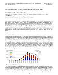
Obstructi<strong>on</strong> generated by closely spaced three <str<strong>on</strong>g>bridge</str<strong>on</strong>g>s<br />
Within the study area <str<strong>on</strong>g>of</str<strong>on</strong>g> the Surma, there exists two more <str<strong>on</strong>g>bridge</str<strong>on</strong>g>s (known as Kaen <str<strong>on</strong>g>bridge</str<strong>on</strong>g> and Notun or New<br />
ShahJalal <str<strong>on</strong>g>bridge</str<strong>on</strong>g>) which are closely apart (850 m) to the under c<strong>on</strong>structi<strong>on</strong> road <str<strong>on</strong>g>bridge</str<strong>on</strong>g>. Generally the <str<strong>on</strong>g>bridge</str<strong>on</strong>g><br />
obstructs the flow <str<strong>on</strong>g>of</str<strong>on</strong>g> the river and having obstructed, the flow tends to adapt its energy causing bed erosi<strong>on</strong> at<br />
immediate downstream <str<strong>on</strong>g>of</str<strong>on</strong>g> the <str<strong>on</strong>g>bridge</str<strong>on</strong>g>. On the c<strong>on</strong>trary, flow at upstream experiences backwater which accelerates<br />
siltati<strong>on</strong>. In this present case, before adapting within the reach from Notun <str<strong>on</strong>g>bridge</str<strong>on</strong>g> to Kaen <str<strong>on</strong>g>bridge</str<strong>on</strong>g>, the<br />
flow again starts to face another obstructi<strong>on</strong> by the under c<strong>on</strong>structi<strong>on</strong> road <str<strong>on</strong>g>bridge</str<strong>on</strong>g>. Obstructi<strong>on</strong> by three<br />
<str<strong>on</strong>g>bridge</str<strong>on</strong>g>s within a very short reach would obviously disturb the hydraulic and morphological scenario.<br />
Abrupt hydrological change <str<strong>on</strong>g>of</str<strong>on</strong>g> the Surma<br />
This river is characterized with the flash flood. Sudden increase <str<strong>on</strong>g>of</str<strong>on</strong>g> flow causes to spill over the bank. On the<br />
c<strong>on</strong>trary, this regi<strong>on</strong> faces also abrupt reducti<strong>on</strong> <str<strong>on</strong>g>of</str<strong>on</strong>g> flow. Drastic changes <str<strong>on</strong>g>of</str<strong>on</strong>g> flow within short period if obstructed<br />
by the <str<strong>on</strong>g>bridge</str<strong>on</strong>g> may generate more adverse situati<strong>on</strong> near the <str<strong>on</strong>g>bridge</str<strong>on</strong>g>. Though both the banks near the<br />
under c<strong>on</strong>structi<strong>on</strong> <str<strong>on</strong>g>bridge</str<strong>on</strong>g> is well protected by the embankment except right bank at immediate downstream <str<strong>on</strong>g>of</str<strong>on</strong>g><br />
the <str<strong>on</strong>g>bridge</str<strong>on</strong>g>, but combinati<strong>on</strong> <str<strong>on</strong>g>of</str<strong>on</strong>g> c<strong>on</strong>stricti<strong>on</strong> with abrupt increase <str<strong>on</strong>g>of</str<strong>on</strong>g> flow may cause damage to this embankment.<br />
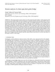
erosi<strong>on</strong> immediate<br />
u/s <str<strong>on</strong>g>of</str<strong>on</strong>g> the <str<strong>on</strong>g>bridge</str<strong>on</strong>g><br />
mediate<br />
dge<br />
Siltati<strong>on</strong> immediate<br />
u/s <str<strong>on</strong>g>of</str<strong>on</strong>g> the<br />
<str<strong>on</strong>g>bridge</str<strong>on</strong>g><br />
Flow directi<strong>on</strong><br />
Figure 1.1 Arial photo graph <str<strong>on</strong>g>of</str<strong>on</strong>g> <str<strong>on</strong>g>bridge</str<strong>on</strong>g> locati<strong>on</strong><br />
1.3 Approach and Methodology<br />
Key approach and methodology adopted to achieve the desired output is mainly mathematical modelling <str<strong>on</strong>g>of</str<strong>on</strong>g><br />
the Surma River <str<strong>on</strong>g>of</str<strong>on</strong>g> the selected reach. In order to analyze the baseline and predicted hydrodynamic and morphological<br />
c<strong>on</strong>diti<strong>on</strong>s at and around the <str<strong>on</strong>g>bridge</str<strong>on</strong>g>, a 2D morphological model has been developed using<br />
MIKE21C (Developed by DHI) modelling system. The developed two-dimensi<strong>on</strong>al morphological model <str<strong>on</strong>g>of</str<strong>on</strong>g><br />
the Surma River is simulated for different scenarios to understand the short term changes <str<strong>on</strong>g>of</str<strong>on</strong>g> the river. This<br />
model extends from 12.5 km upstream <str<strong>on</strong>g>of</str<strong>on</strong>g> the Bridge to 12.5 km downstream covering total 25 km in length.<br />
Prior to development <str<strong>on</strong>g>of</str<strong>on</strong>g> the mathematical modelling, data analysis have been d<strong>on</strong>e extensively to form the<br />
basis <str<strong>on</strong>g>of</str<strong>on</strong>g> hydraulic process related to the hydraulic and morphological c<strong>on</strong>diti<strong>on</strong> in the vicinity <str<strong>on</strong>g>of</str<strong>on</strong>g> the Bridge.<br />
The analysis <str<strong>on</strong>g>of</str<strong>on</strong>g> the past hydro-morphological data (changes in the channel geometry, char movement, impinging<br />
flow, surface elevati<strong>on</strong> etc) have not <strong>on</strong>ly formed the basis <str<strong>on</strong>g>of</str<strong>on</strong>g> understanding but also enhanced the<br />
c<strong>on</strong>fidence to interpret the model generated outputs.<br />
370