Effect of bridge pier on waterways constriction - Bangladesh Group ...
Effect of bridge pier on waterways constriction - Bangladesh Group ...
Effect of bridge pier on waterways constriction - Bangladesh Group ...

Create successful ePaper yourself
Turn your PDF publications into a flip-book with our unique Google optimized e-Paper software.
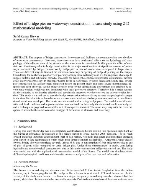
IABSE-JSCE Joint C<strong>on</strong>ference <strong>on</strong> Advances in Bridge Engineering-II, August 8-10, 2010, Dhaka, <strong>Bangladesh</strong>. ISBN: 978-984-33-1893-0<br />
Amin, Okui, Bhuiyan (eds.)<br />
www.iabse-bd.org<br />
<str<strong>on</strong>g>Effect</str<strong>on</strong>g> <str<strong>on</strong>g>of</str<strong>on</strong>g> <str<strong>on</strong>g>bridge</str<strong>on</strong>g> <str<strong>on</strong>g>pier</str<strong>on</strong>g> <strong>on</strong> <strong>waterways</strong> c<strong>on</strong>stricti<strong>on</strong>: a case study using 2-D<br />
mathematical modeling<br />
Sufal Kumar Biswas<br />
Institute <str<strong>on</strong>g>of</str<strong>on</strong>g> Water Modelling, House 496, Road 32, New DOHS, Mohakhali, Dhaka 1206, <strong>Bangladesh</strong><br />
ABSTRACT: The purpose <str<strong>on</strong>g>of</str<strong>on</strong>g> <str<strong>on</strong>g>bridge</str<strong>on</strong>g> c<strong>on</strong>structi<strong>on</strong> is to ensure and facilitate the communicati<strong>on</strong> over the flow<br />
<str<strong>on</strong>g>of</str<strong>on</strong>g> <strong>waterways</strong> c<strong>on</strong>veniently. However, these structures have detrimental effects <strong>on</strong> the hydrology and morphology<br />
<str<strong>on</strong>g>of</str<strong>on</strong>g> the adjacent area <str<strong>on</strong>g>of</str<strong>on</strong>g> the streams as the <strong>waterways</strong> is c<strong>on</strong>stricted. In this paper the effect <str<strong>on</strong>g>of</str<strong>on</strong>g> c<strong>on</strong>stricti<strong>on</strong><br />
<str<strong>on</strong>g>of</str<strong>on</strong>g> <strong>waterways</strong> due to <str<strong>on</strong>g>bridge</str<strong>on</strong>g> c<strong>on</strong>structi<strong>on</strong> is the major c<strong>on</strong>siderati<strong>on</strong>. A significant amount <str<strong>on</strong>g>of</str<strong>on</strong>g> <strong>waterways</strong><br />
is occupied by <str<strong>on</strong>g>bridge</str<strong>on</strong>g> c<strong>on</strong>structi<strong>on</strong> by <str<strong>on</strong>g>bridge</str<strong>on</strong>g> <str<strong>on</strong>g>pier</str<strong>on</strong>g> in case <str<strong>on</strong>g>of</str<strong>on</strong>g> smaller rivers compared to larger rivers.<br />
There are different ways to find out the minimum waterway or opening <str<strong>on</strong>g>of</str<strong>on</strong>g> <str<strong>on</strong>g>bridge</str<strong>on</strong>g> depending <strong>on</strong> the shapes.<br />
C<strong>on</strong>sidering the aesthetical point <str<strong>on</strong>g>of</str<strong>on</strong>g> view <str<strong>on</strong>g>pier</str<strong>on</strong>g> may occupy more <strong>waterways</strong> and it’s the engineers challenge to<br />
suggest suitable and substantial remedial measures for making the c<strong>on</strong>structi<strong>on</strong> possible with nominal adverse<br />
effect <strong>on</strong> river morphology. In this paper Surma River in Kazirbazar, Sylhet is taken as the study area. Bridge<br />
<str<strong>on</strong>g>pier</str<strong>on</strong>g> c<strong>on</strong>structi<strong>on</strong> has already been completed before the present study and some severe morphological resp<strong>on</strong>se<br />
has been observed. At the <str<strong>on</strong>g>bridge</str<strong>on</strong>g> locati<strong>on</strong> both for the upstream and downstream it is affected by severe<br />
bank erosi<strong>on</strong>, which was not, terminated with usual protective measures. Therefore, it is a major c<strong>on</strong>cern<br />
for the authority to acclimatize effective and sustainable measures to reduce or stop the current erosi<strong>on</strong> incident.<br />
This study is carried out to ease the <str<strong>on</strong>g>bridge</str<strong>on</strong>g> c<strong>on</strong>structi<strong>on</strong> without facing adverse morphological changes<br />
in the river.To solve this problem historical data <strong>on</strong> water level and discharge was analyzed and a two dimensi<strong>on</strong>al<br />
model was developed. The model was simulated with existing <str<strong>on</strong>g>bridge</str<strong>on</strong>g> <str<strong>on</strong>g>pier</str<strong>on</strong>g>s. The model was calibrated<br />
with real field c<strong>on</strong>diti<strong>on</strong> and apposite soluti<strong>on</strong> was outlined. In this study the simulated result was analyzed<br />
and a technique is proposed to avoid this sort <str<strong>on</strong>g>of</str<strong>on</strong>g> unexpected incident. The result may vary with the river but<br />
approach would be the same to resolve this type <str<strong>on</strong>g>of</str<strong>on</strong>g> difficulties in all rivers and water way.<br />
1 INTRODUCTION<br />
1.1 Background<br />
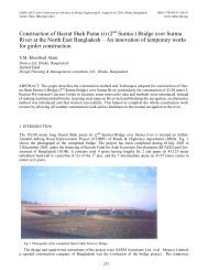
During this study the <str<strong>on</strong>g>bridge</str<strong>on</strong>g> was not completely c<strong>on</strong>structed and before coming into operati<strong>on</strong>, right bank <str<strong>on</strong>g>of</str<strong>on</strong>g><br />
the Surma at immediate downstream <str<strong>on</strong>g>of</str<strong>on</strong>g> the <str<strong>on</strong>g>bridge</str<strong>on</strong>g> started to erode. During 2008 m<strong>on</strong>so<strong>on</strong>, 150 m reach<br />
eroded engulfing important establishment (part <str<strong>on</strong>g>of</str<strong>on</strong>g> fish market, rice mills and other) and immediate upstream<br />
area started to face sedimentati<strong>on</strong> which might pose threat to smooth navigability. Apparently, water area <str<strong>on</strong>g>of</str<strong>on</strong>g><br />
river at <str<strong>on</strong>g>bridge</str<strong>on</strong>g> site was c<strong>on</strong>stricted severely (about 33 % due to c<strong>on</strong>sumpti<strong>on</strong> <str<strong>on</strong>g>of</str<strong>on</strong>g> four <str<strong>on</strong>g>bridge</str<strong>on</strong>g> <str<strong>on</strong>g>pier</str<strong>on</strong>g>s) due to use<br />
<str<strong>on</strong>g>of</str<strong>on</strong>g> <str<strong>on</strong>g>pier</str<strong>on</strong>g> <str<strong>on</strong>g>of</str<strong>on</strong>g> great width compared to usual <str<strong>on</strong>g>bridge</str<strong>on</strong>g> <str<strong>on</strong>g>pier</str<strong>on</strong>g>. Under these circumstances, a study, c<strong>on</strong>sidering<br />
hydraulic and morphological c<strong>on</strong>sequences, due to this under-c<strong>on</strong>structi<strong>on</strong> <str<strong>on</strong>g>bridge</str<strong>on</strong>g> was carried out. The study<br />
was carried out with the applicati<strong>on</strong> <str<strong>on</strong>g>of</str<strong>on</strong>g> mathematical model <str<strong>on</strong>g>of</str<strong>on</strong>g> the Surma. The model was simulated under<br />
different hydrological c<strong>on</strong>diti<strong>on</strong>s and also with extensive analysis <str<strong>on</strong>g>of</str<strong>on</strong>g> the past data and informati<strong>on</strong>.<br />
1.2 Problem Statement<br />
Siltati<strong>on</strong> <str<strong>on</strong>g>of</str<strong>on</strong>g> the Surma<br />
The Surma is a meandering and dynamic river. It has travelled 215 km inside <strong>Bangladesh</strong> from the Indian<br />
boundary up to Sunamgang district. The <str<strong>on</strong>g>bridge</str<strong>on</strong>g> at Kazir bazaar is located at 111 th km <str<strong>on</strong>g>of</str<strong>on</strong>g> Surma river. In the<br />
vicinity <str<strong>on</strong>g>of</str<strong>on</strong>g> the study area Surma river flows in a single, irregularly meandering sand-bed channel that frequently<br />
deflects <str<strong>on</strong>g>of</str<strong>on</strong>g>f bedrock and other inerodible deposits. Past studies and analysis <str<strong>on</strong>g>of</str<strong>on</strong>g> the cross secti<strong>on</strong>al data<br />
369
indicate siltati<strong>on</strong> in the Surma after taking <str<strong>on</strong>g>of</str<strong>on</strong>g>f from the Barak. Due to this c<strong>on</strong>tinued siltati<strong>on</strong>, the c<strong>on</strong>veyance<br />
capacity <str<strong>on</strong>g>of</str<strong>on</strong>g> this river is also reducing.<br />
FAP 6 reveals that the width <str<strong>on</strong>g>of</str<strong>on</strong>g> this river is in the order <str<strong>on</strong>g>of</str<strong>on</strong>g> 170 m where mean depth is 8.6 m at bankful discharge.<br />
In 1992, the width <str<strong>on</strong>g>of</str<strong>on</strong>g> this river at Sylhet reached 40 m during dry period and the depth was <strong>on</strong>ly 2 m,<br />
though at downstream <str<strong>on</strong>g>of</str<strong>on</strong>g> Chattak, width became higher (250 m) and depth (10.2 m).<br />
Obstructi<strong>on</strong> generated by closely spaced three <str<strong>on</strong>g>bridge</str<strong>on</strong>g>s<br />
Within the study area <str<strong>on</strong>g>of</str<strong>on</strong>g> the Surma, there exists two more <str<strong>on</strong>g>bridge</str<strong>on</strong>g>s (known as Kaen <str<strong>on</strong>g>bridge</str<strong>on</strong>g> and Notun or New<br />
ShahJalal <str<strong>on</strong>g>bridge</str<strong>on</strong>g>) which are closely apart (850 m) to the under c<strong>on</strong>structi<strong>on</strong> road <str<strong>on</strong>g>bridge</str<strong>on</strong>g>. Generally the <str<strong>on</strong>g>bridge</str<strong>on</strong>g><br />
obstructs the flow <str<strong>on</strong>g>of</str<strong>on</strong>g> the river and having obstructed, the flow tends to adapt its energy causing bed erosi<strong>on</strong> at<br />
immediate downstream <str<strong>on</strong>g>of</str<strong>on</strong>g> the <str<strong>on</strong>g>bridge</str<strong>on</strong>g>. On the c<strong>on</strong>trary, flow at upstream experiences backwater which accelerates<br />
siltati<strong>on</strong>. In this present case, before adapting within the reach from Notun <str<strong>on</strong>g>bridge</str<strong>on</strong>g> to Kaen <str<strong>on</strong>g>bridge</str<strong>on</strong>g>, the<br />
flow again starts to face another obstructi<strong>on</strong> by the under c<strong>on</strong>structi<strong>on</strong> road <str<strong>on</strong>g>bridge</str<strong>on</strong>g>. Obstructi<strong>on</strong> by three<br />
<str<strong>on</strong>g>bridge</str<strong>on</strong>g>s within a very short reach would obviously disturb the hydraulic and morphological scenario.<br />
Abrupt hydrological change <str<strong>on</strong>g>of</str<strong>on</strong>g> the Surma<br />
This river is characterized with the flash flood. Sudden increase <str<strong>on</strong>g>of</str<strong>on</strong>g> flow causes to spill over the bank. On the<br />
c<strong>on</strong>trary, this regi<strong>on</strong> faces also abrupt reducti<strong>on</strong> <str<strong>on</strong>g>of</str<strong>on</strong>g> flow. Drastic changes <str<strong>on</strong>g>of</str<strong>on</strong>g> flow within short period if obstructed<br />
by the <str<strong>on</strong>g>bridge</str<strong>on</strong>g> may generate more adverse situati<strong>on</strong> near the <str<strong>on</strong>g>bridge</str<strong>on</strong>g>. Though both the banks near the<br />
under c<strong>on</strong>structi<strong>on</strong> <str<strong>on</strong>g>bridge</str<strong>on</strong>g> is well protected by the embankment except right bank at immediate downstream <str<strong>on</strong>g>of</str<strong>on</strong>g><br />
the <str<strong>on</strong>g>bridge</str<strong>on</strong>g>, but combinati<strong>on</strong> <str<strong>on</strong>g>of</str<strong>on</strong>g> c<strong>on</strong>stricti<strong>on</strong> with abrupt increase <str<strong>on</strong>g>of</str<strong>on</strong>g> flow may cause damage to this embankment.<br />
erosi<strong>on</strong> immediate<br />
u/s <str<strong>on</strong>g>of</str<strong>on</strong>g> the <str<strong>on</strong>g>bridge</str<strong>on</strong>g><br />
mediate<br />
dge<br />
Siltati<strong>on</strong> immediate<br />
u/s <str<strong>on</strong>g>of</str<strong>on</strong>g> the<br />
<str<strong>on</strong>g>bridge</str<strong>on</strong>g><br />
Flow directi<strong>on</strong><br />
Figure 1.1 Arial photo graph <str<strong>on</strong>g>of</str<strong>on</strong>g> <str<strong>on</strong>g>bridge</str<strong>on</strong>g> locati<strong>on</strong><br />
1.3 Approach and Methodology<br />
Key approach and methodology adopted to achieve the desired output is mainly mathematical modelling <str<strong>on</strong>g>of</str<strong>on</strong>g><br />
the Surma River <str<strong>on</strong>g>of</str<strong>on</strong>g> the selected reach. In order to analyze the baseline and predicted hydrodynamic and morphological<br />
c<strong>on</strong>diti<strong>on</strong>s at and around the <str<strong>on</strong>g>bridge</str<strong>on</strong>g>, a 2D morphological model has been developed using<br />
MIKE21C (Developed by DHI) modelling system. The developed two-dimensi<strong>on</strong>al morphological model <str<strong>on</strong>g>of</str<strong>on</strong>g><br />
the Surma River is simulated for different scenarios to understand the short term changes <str<strong>on</strong>g>of</str<strong>on</strong>g> the river. This<br />
model extends from 12.5 km upstream <str<strong>on</strong>g>of</str<strong>on</strong>g> the Bridge to 12.5 km downstream covering total 25 km in length.<br />
Prior to development <str<strong>on</strong>g>of</str<strong>on</strong>g> the mathematical modelling, data analysis have been d<strong>on</strong>e extensively to form the<br />
basis <str<strong>on</strong>g>of</str<strong>on</strong>g> hydraulic process related to the hydraulic and morphological c<strong>on</strong>diti<strong>on</strong> in the vicinity <str<strong>on</strong>g>of</str<strong>on</strong>g> the Bridge.<br />
The analysis <str<strong>on</strong>g>of</str<strong>on</strong>g> the past hydro-morphological data (changes in the channel geometry, char movement, impinging<br />
flow, surface elevati<strong>on</strong> etc) have not <strong>on</strong>ly formed the basis <str<strong>on</strong>g>of</str<strong>on</strong>g> understanding but also enhanced the<br />
c<strong>on</strong>fidence to interpret the model generated outputs.<br />
370
Since the Brooklyn Bridge was built in New York City in the late 1800’s virtually all main cables <str<strong>on</strong>g>of</str<strong>on</strong>g> major<br />
suspensi<strong>on</strong> <str<strong>on</strong>g>bridge</str<strong>on</strong>g>s have been c<strong>on</strong>structed <str<strong>on</strong>g>of</str<strong>on</strong>g> high strength galvanized steel wire. Until the mid-twentieth century,<br />
all large suspensi<strong>on</strong> <str<strong>on</strong>g>bridge</str<strong>on</strong>g> cables were air spun by pulling <strong>on</strong>e or more pairs <str<strong>on</strong>g>of</str<strong>on</strong>g> wires at a time from <strong>on</strong>e<br />
anchorage to the other and adjusting each wire to theoretically share the load equally with the others. In 1969,<br />
the Newport Bridge in Rhode Island was c<strong>on</strong>structed using shop-fabricated parallel wire strands (PPWS), the<br />
method that has now gained favor for many new <str<strong>on</strong>g>bridge</str<strong>on</strong>g>s.<br />
Since John A. Roebling pi<strong>on</strong>eered the art <str<strong>on</strong>g>of</str<strong>on</strong>g> suspensi<strong>on</strong> <str<strong>on</strong>g>bridge</str<strong>on</strong>g> design, the main cables <str<strong>on</strong>g>of</str<strong>on</strong>g> suspensi<strong>on</strong><br />
<str<strong>on</strong>g>bridge</str<strong>on</strong>g>s have typically been protected by a tight covering <str<strong>on</strong>g>of</str<strong>on</strong>g> s<str<strong>on</strong>g>of</str<strong>on</strong>g>t wire wrapping bedded in a sealing paste,<br />
usually red-lead (Pb3O4) in linseed oil, and coated with paint. Some excepti<strong>on</strong>s are notable, such as the Newport<br />
and Bidwell Bar (Oroville, California, U.S.A., 1965) Bridges where glass-reinforced acrylic was used,<br />
and the William Prest<strong>on</strong> Lane Bridge (Maryland, U.S.A., 1973) where neoprene sheet was used.<br />
Recognizing the advantage <str<strong>on</strong>g>of</str<strong>on</strong>g> using an impervious covering <strong>on</strong> the cables, a number <str<strong>on</strong>g>of</str<strong>on</strong>g> U.S. suspensi<strong>on</strong><br />
<str<strong>on</strong>g>bridge</str<strong>on</strong>g>s have been retr<str<strong>on</strong>g>of</str<strong>on</strong>g>itted with elastomeric coverings placed over the existing wrapping wire. There are<br />
now a number <str<strong>on</strong>g>of</str<strong>on</strong>g> <str<strong>on</strong>g>bridge</str<strong>on</strong>g>s in Europe and Japan that use a dry-air injecti<strong>on</strong> system in c<strong>on</strong>juncti<strong>on</strong> with an elastomeric<br />
wrapping to ensure that no moisture can enter the cables. Some suspensi<strong>on</strong> <str<strong>on</strong>g>bridge</str<strong>on</strong>g>s have also been<br />
c<strong>on</strong>structed using twisted strands. The inspecti<strong>on</strong> is significantly different for this type <str<strong>on</strong>g>of</str<strong>on</strong>g> <str<strong>on</strong>g>bridge</str<strong>on</strong>g>s and is<br />
therefore not covered in this paper.<br />
2 MODEL DEVELOPMENT AND ASSESSMENT OF IMPACT OF BRIDGE<br />
2.1 Model Generati<strong>on</strong><br />
In order to determine the impact <str<strong>on</strong>g>of</str<strong>on</strong>g> the under c<strong>on</strong>structi<strong>on</strong> <str<strong>on</strong>g>bridge</str<strong>on</strong>g> the model covers 25 km river reach representing<br />
the bed level <str<strong>on</strong>g>of</str<strong>on</strong>g> pre m<strong>on</strong>so<strong>on</strong> (March-April) 2009. River resp<strong>on</strong>ses due to existing under c<strong>on</strong>structi<strong>on</strong><br />
kazirbazar <str<strong>on</strong>g>bridge</str<strong>on</strong>g> has been observed from the models being subject to different flood c<strong>on</strong>diti<strong>on</strong>s and analysed<br />
in relati<strong>on</strong> with the hydraulic and morphological characteristics <str<strong>on</strong>g>of</str<strong>on</strong>g> the Surma. Impact <str<strong>on</strong>g>of</str<strong>on</strong>g> the <str<strong>on</strong>g>bridge</str<strong>on</strong>g> in bank<br />
erosi<strong>on</strong>, in flow thrust, bed erosi<strong>on</strong>/depositi<strong>on</strong>, back water etc has been determined comparing with the past<br />
and existing field c<strong>on</strong>diti<strong>on</strong>. Attempt has been made to compare the river hydraulic and morphological characteristics<br />
between “with” and “without <str<strong>on</strong>g>bridge</str<strong>on</strong>g>” c<strong>on</strong>diti<strong>on</strong>. In order to do so, “without <str<strong>on</strong>g>bridge</str<strong>on</strong>g>” c<strong>on</strong>diti<strong>on</strong> has<br />
been generated in the model c<strong>on</strong>sidering n<strong>on</strong> existentence <str<strong>on</strong>g>of</str<strong>on</strong>g> kazir bazaar <str<strong>on</strong>g>bridge</str<strong>on</strong>g>. Model development actually<br />
covers the following steps sequentially<br />
• Generati<strong>on</strong> <str<strong>on</strong>g>of</str<strong>on</strong>g> computati<strong>on</strong>al grid or cell where each <str<strong>on</strong>g>of</str<strong>on</strong>g> the cell would c<strong>on</strong>tain the input and outputs;<br />
• Preparati<strong>on</strong> <str<strong>on</strong>g>of</str<strong>on</strong>g> model initial bathymetry (recently surveyed cross secti<strong>on</strong> @ 50m interval) which represents<br />
the river bed<br />
• Determinati<strong>on</strong> <str<strong>on</strong>g>of</str<strong>on</strong>g> initial and boundary c<strong>on</strong>diti<strong>on</strong>s and<br />
• Calibrati<strong>on</strong> <str<strong>on</strong>g>of</str<strong>on</strong>g> the model for evaluating the performance <str<strong>on</strong>g>of</str<strong>on</strong>g> the model.<br />
2.2 C<strong>on</strong>sidering Event and Boundary c<strong>on</strong>diti<strong>on</strong><br />
In order to determine the c<strong>on</strong>sequence <str<strong>on</strong>g>of</str<strong>on</strong>g> the <str<strong>on</strong>g>bridge</str<strong>on</strong>g>, mathematical model <str<strong>on</strong>g>of</str<strong>on</strong>g> the Surma within the <str<strong>on</strong>g>bridge</str<strong>on</strong>g> has<br />
been applied for average and extreme flood events. Selecti<strong>on</strong> <str<strong>on</strong>g>of</str<strong>on</strong>g> these flood events is based <strong>on</strong> frequently<br />
occurrence <str<strong>on</strong>g>of</str<strong>on</strong>g> average flood and worst scenario. Having collected all the historical data <str<strong>on</strong>g>of</str<strong>on</strong>g> flow and water<br />
level, frequency analysis has been d<strong>on</strong>e to determine the design event to be used as the boundary c<strong>on</strong>diti<strong>on</strong> <str<strong>on</strong>g>of</str<strong>on</strong>g><br />
the numerical model.<br />
In order to carry out the statistical analysis <str<strong>on</strong>g>of</str<strong>on</strong>g> the probable discharge <str<strong>on</strong>g>of</str<strong>on</strong>g> the Surma, discharge data measured<br />
at Sylhet gauge stati<strong>on</strong> from 1962 to 2007 has been used.<br />
Two dimensi<strong>on</strong>al models have two boundaries. As per rule, upstream boundary is defined as a single discharge<br />
boundary or a discharge time series and downstream boundary is defined as corresp<strong>on</strong>ding single water<br />
level or water level time series. Available discharge data <str<strong>on</strong>g>of</str<strong>on</strong>g> Sylhet stati<strong>on</strong> is used as upstream boundary <str<strong>on</strong>g>of</str<strong>on</strong>g><br />
the 2D model. For water level boundary is determined from the slope analysis using as a reference <str<strong>on</strong>g>of</str<strong>on</strong>g> Sylhet<br />
water level stati<strong>on</strong>. It is worth menti<strong>on</strong>ing there that downstream boundary <str<strong>on</strong>g>of</str<strong>on</strong>g> the model is located at 12.5km<br />
from Sylhet water level stati<strong>on</strong>. In this case no inflow and outflow have been included since within the study<br />
area, there is no such inflow and outflow. The model was simulated for extreme event <str<strong>on</strong>g>of</str<strong>on</strong>g> 100 years return period<br />
(2004) and average flow (2.33 years return period which means 1985)<br />
371
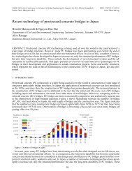
Table 2.1. Probable Discharges <str<strong>on</strong>g>of</str<strong>on</strong>g> Surma River at Sylhet stati<strong>on</strong> for different return periods<br />
_________________________________________________________________________<br />
Return Period Estimated Corresp<strong>on</strong>ding Observed Peak<br />
(Year) Discharge(m 3 /s) Hydrological Year Discharge(m 3 /s)<br />
Log Normal<br />
Distributi<strong>on</strong><br />
____________ ____________ _____________ ____________<br />
2 1924 1985 1940<br />
5 2152 1991 2150<br />
10 2273 1988 2300<br />
25 2404 1966 2340<br />
50 2489 1976 2480<br />
100 2600 2004 2500<br />
______________________________________________________________________<br />
Figure 2.1 Probability graph for discharge <str<strong>on</strong>g>of</str<strong>on</strong>g> the Surma River at Sylhet stati<strong>on</strong><br />
Figure 2.2. Boundary C<strong>on</strong>diti<strong>on</strong> for extreme flood event (100 yr return period)<br />
Figure 2.3. Boundary C<strong>on</strong>diti<strong>on</strong> for average flood event (2.33 yr return period)<br />
372
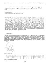
Initial C<strong>on</strong>diti<strong>on</strong><br />
Diminishing <str<strong>on</strong>g>of</str<strong>on</strong>g> shallow area<br />
Initiati<strong>on</strong> <str<strong>on</strong>g>of</str<strong>on</strong>g> silta-<br />
Initiati<strong>on</strong> <str<strong>on</strong>g>of</str<strong>on</strong>g> silta-<br />
Initiati<strong>on</strong> <str<strong>on</strong>g>of</str<strong>on</strong>g> ero-<br />
Initiati<strong>on</strong> <str<strong>on</strong>g>of</str<strong>on</strong>g> ero-<br />
Figure 3.1. Bed level c<strong>on</strong>tour for average flood event (2.33 yr return period) at different stage <str<strong>on</strong>g>of</str<strong>on</strong>g> m<strong>on</strong>so<strong>on</strong><br />
373
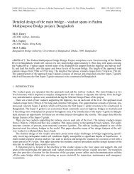
Initial C<strong>on</strong>diti<strong>on</strong><br />
depositi<strong>on</strong><br />
Bed erosi<strong>on</strong><br />
depositi<strong>on</strong><br />
Bed erosi<strong>on</strong><br />
Bed erosi<strong>on</strong><br />
Depositi<strong>on</strong><br />
Extent <str<strong>on</strong>g>of</str<strong>on</strong>g> bed erosi<strong>on</strong><br />
Bed erosi<strong>on</strong><br />
Bed erosi<strong>on</strong><br />
Depositi<strong>on</strong><br />
Figure 3.2. Bed level c<strong>on</strong>tour for extreme (100 yr return period) flood event at different stage <str<strong>on</strong>g>of</str<strong>on</strong>g> m<strong>on</strong>so<strong>on</strong><br />
374
3 ASSESSMENT OF IMPACT OF BRIDGE<br />
In this study it was intended to investigate the siltati<strong>on</strong> or bed scouring c<strong>on</strong>diti<strong>on</strong> particularly at the <str<strong>on</strong>g>bridge</str<strong>on</strong>g><br />
area. Model results including the <str<strong>on</strong>g>bridge</str<strong>on</strong>g> show huge depositi<strong>on</strong> at upstream <str<strong>on</strong>g>of</str<strong>on</strong>g> the <str<strong>on</strong>g>bridge</str<strong>on</strong>g> al<strong>on</strong>g the left bank.<br />
Prior to simulati<strong>on</strong> i.e. at the initial stage <str<strong>on</strong>g>of</str<strong>on</strong>g> the m<strong>on</strong>so<strong>on</strong>, thalweg was al<strong>on</strong>g the left bank at upstream but<br />
having underg<strong>on</strong>e with the extreme or even average flood c<strong>on</strong>diti<strong>on</strong>, thalweg shifted from left to right diminishing<br />
the shallow area near the right bank at immediate upstream <str<strong>on</strong>g>of</str<strong>on</strong>g> the <str<strong>on</strong>g>bridge</str<strong>on</strong>g>.On the c<strong>on</strong>trary, huge bed<br />
scour is observed al<strong>on</strong>g both the banks <str<strong>on</strong>g>of</str<strong>on</strong>g> the Surma at and around under c<strong>on</strong>structi<strong>on</strong> <str<strong>on</strong>g>bridge</str<strong>on</strong>g>. Bed degradati<strong>on</strong><br />
al<strong>on</strong>g the right bank extends from <str<strong>on</strong>g>bridge</str<strong>on</strong>g> area to about 500 m downstream whereas at upstream, it extends<br />
more than 1 km. Figure 3.1 and 3.2 show the bed level c<strong>on</strong>tours for average and extreme flood c<strong>on</strong>diti<strong>on</strong>s.<br />
Both events present the same siltati<strong>on</strong> phenomena at same locati<strong>on</strong>s with different severity.<br />
Al<strong>on</strong>g with the spatial c<strong>on</strong>tour <str<strong>on</strong>g>of</str<strong>on</strong>g> the bed level at different stages <str<strong>on</strong>g>of</str<strong>on</strong>g> the m<strong>on</strong>so<strong>on</strong>, vertical extent <str<strong>on</strong>g>of</str<strong>on</strong>g> bed<br />
degradati<strong>on</strong> with the help <str<strong>on</strong>g>of</str<strong>on</strong>g> the cross secti<strong>on</strong>al pr<str<strong>on</strong>g>of</str<strong>on</strong>g>iles at the peak and at the end <str<strong>on</strong>g>of</str<strong>on</strong>g> the m<strong>on</strong>so<strong>on</strong> are also<br />
shown for different secti<strong>on</strong>s around the <str<strong>on</strong>g>bridge</str<strong>on</strong>g>, Figure 3.3 to 3.5. These plots show the variati<strong>on</strong> <str<strong>on</strong>g>of</str<strong>on</strong>g> the bed<br />
scouring for extreme events with respect to the surveyed bed c<strong>on</strong>diti<strong>on</strong> at April 2009. It is seen that at downstream<br />
<str<strong>on</strong>g>of</str<strong>on</strong>g> the <str<strong>on</strong>g>bridge</str<strong>on</strong>g>, bed scouring ranges from 1 to 5 meter associated with the thalweg movement from<br />
middle to left bank. Such changes i.e. bed scouring al<strong>on</strong>g the left bank extends approximately 1 km downstream<br />
from the <str<strong>on</strong>g>bridge</str<strong>on</strong>g>. At immediate upstream al<strong>on</strong>g the right bank, scouring is more severe than that at<br />
downstream. Bed level undergoes from 10 to 15 m from surveyed bed. Exactly at <str<strong>on</strong>g>bridge</str<strong>on</strong>g> locati<strong>on</strong>, bed scouring<br />
is not so substantial and remains within 8 m. Spatial extent <str<strong>on</strong>g>of</str<strong>on</strong>g> bed scouring al<strong>on</strong>g the right bank is from 1<br />
km upstream to 500 m downstream <str<strong>on</strong>g>of</str<strong>on</strong>g> the <str<strong>on</strong>g>bridge</str<strong>on</strong>g>.<br />
Figure 3.3: Simulated cross secti<strong>on</strong>s al<strong>on</strong>g with surveyed bed level at different stage <str<strong>on</strong>g>of</str<strong>on</strong>g> extreme flood event at 450 m upstream <str<strong>on</strong>g>of</str<strong>on</strong>g><br />
the <str<strong>on</strong>g>bridge</str<strong>on</strong>g><br />
Figure 3.4: Simulated cross secti<strong>on</strong>s al<strong>on</strong>g with surveyed bed level at different stage <str<strong>on</strong>g>of</str<strong>on</strong>g> extreme flood event at <str<strong>on</strong>g>bridge</str<strong>on</strong>g> site<br />
375
Figure 3.5: Simulated cross secti<strong>on</strong>s al<strong>on</strong>g with surveyed bed level at different stage <str<strong>on</strong>g>of</str<strong>on</strong>g> extreme flood event at 700 m downstream<br />
<str<strong>on</strong>g>of</str<strong>on</strong>g> the <str<strong>on</strong>g>bridge</str<strong>on</strong>g><br />
4 CONCLUSION<br />
From this study it can be anticipated that if the water ways become c<strong>on</strong>strict, bank erosi<strong>on</strong> and scour bey<strong>on</strong>d<br />
expected may be happened. To avoid this drastic situati<strong>on</strong>, river training work from 1km upstream to 1 km<br />
downstream may be recommended and c<strong>on</strong>tinuous m<strong>on</strong>itoring should be c<strong>on</strong>ducted during and after c<strong>on</strong>structi<strong>on</strong><br />
<str<strong>on</strong>g>of</str<strong>on</strong>g> such type <str<strong>on</strong>g>of</str<strong>on</strong>g> structure at stated situati<strong>on</strong>.<br />
5 LIMITATIONS<br />
The study output was <strong>on</strong>ly bed level change and bank erosi<strong>on</strong>. There were differences in water level as well<br />
as current speed. The outcome <str<strong>on</strong>g>of</str<strong>on</strong>g> the study is based <strong>on</strong> existing c<strong>on</strong>diti<strong>on</strong> <str<strong>on</strong>g>of</str<strong>on</strong>g> Surma river. The approach may<br />
be same for all river but possibility <str<strong>on</strong>g>of</str<strong>on</strong>g> deviati<strong>on</strong> exists in the case <str<strong>on</strong>g>of</str<strong>on</strong>g> other base c<strong>on</strong>diti<strong>on</strong> and other rivers. The<br />
result also varied with soil c<strong>on</strong>diti<strong>on</strong>, current speed, wave acti<strong>on</strong>, tidal acti<strong>on</strong>, surface run<str<strong>on</strong>g>of</str<strong>on</strong>g>f and so <strong>on</strong>.<br />
6 REFERENCES<br />
FAP 6, April 1993, Pre-feasibility Study <str<strong>on</strong>g>of</str<strong>on</strong>g> Upper Surma-Kushiyara Project.<br />
FAP 6, December 1993, Surma-Kushiyara-Bualai Basin Project.<br />
FAP 6, December 1994, Northeast regi<strong>on</strong>al water Management Project,<br />
Special Study, River sedimentati<strong>on</strong> and morphology, Final Report.<br />
IWM, March 2007,Mathematical Modelling al<strong>on</strong>g with Hydrological Studies and Terrestrial Survey under<br />
the Haor Rehabilitati<strong>on</strong> Scheme,Final Report.<br />
IUCN, 2005, Hydro-Meteorological Characteristics <str<strong>on</strong>g>of</str<strong>on</strong>g> Hakaluki Haor<br />
376