

A Benthic Terrain Classification Scheme for American Samoa
A Benthic Terrain Classification Scheme for American Samoa
A Benthic Terrain Classification Scheme for American Samoa

Create successful ePaper yourself
Turn your PDF publications into a flip-book with our unique Google optimized e-Paper software.
BPI was calculated in the ArcGIS raster calculator using the focal mean<br />
calculation described above; the resulting grid values are converted to integers to<br />
minimize the storage size of the grid and to simplify symbolization (Algorithm 1).<br />
Algorithm 1 creates a BPI grid using bathymetry and user defined radii:<br />
scalefactor = outer radius in map units multiplied by bathymetric data resolution<br />
irad = inner radius of annulus in cells<br />
orad = outer radius of annulus in cells<br />
bathy = bathymetric grid<br />
rad = radius (if using circle instead of annulus)<br />
BPI = int((bathy – focalmean(bathy, annulus, irad, orad)) + 0.5)<br />
OR<br />
BPI = int((bathy – focalmean(bathy, circle, rad)) + 0.5)<br />
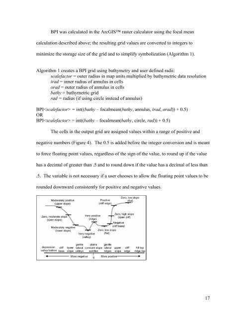
The cells in the output grid are assigned values within a range of positive and<br />
negative numbers (Figure 4). The 0.5 is added be<strong>for</strong>e the integer conversion and is meant<br />
to <strong>for</strong>ce floating point values, regardless of the sign of the value, to round up if the value<br />
has a decimal of greater than .5 and to round down if the value has a decimal of less than<br />
.5. The variable is not necessary if a user chooses to allow the floating point values to be<br />
rounded downward consistently <strong>for</strong> positive and negative values.<br />
17


