

A Benthic Terrain Classification Scheme for American Samoa
A Benthic Terrain Classification Scheme for American Samoa
A Benthic Terrain Classification Scheme for American Samoa

Create successful ePaper yourself
Turn your PDF publications into a flip-book with our unique Google optimized e-Paper software.
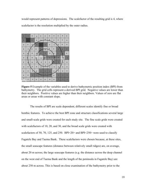
would represent patterns of depressions. The scalefactor of the resulting grid is 4, where<br />
scalefactor is the resolution multiplied by the outer radius.<br />
Figure 5 Example of the variables used to derive bathymetric position index (BPI) from<br />
bathymetry. The grid cells represent a derived BPI grid. Negative values are lower than<br />
their neighbors. Positive values are higher than their neighbors. Values of zero are flat<br />
areas or areas with constant slope.<br />
The results of BPI are scale dependent; different scales identify fine or broad<br />
benthic features. To achieve the best BPI zone and structure classifications several large<br />
and small-scale grids were created <strong>for</strong> each study site. The fine scale grids were created<br />
with scalefactors of 10, 20, and 30, and the broad scale grids were created with<br />
scalefactors of 50, 70, 125, and 250. BPI and BPI were used to classify<br />
Fagatele Bay and Taema Bank. These scalefactors were chosen because, at these sites,<br />
the small seascape features (distance between relatively small ridges) are, on average,<br />
about 20 m across; the large seascape features (e.g. the distance across the deep channel<br />
on the west end of Taema Bank and the length of the peninsula in Fagatele Bay) are<br />
about 250 m across. This is based on close examination of the bathymetry prior to the<br />
19


