Report: Chisholm wildfire entrapment investigation - FPInnovations ...
Report: Chisholm wildfire entrapment investigation - FPInnovations ...
Report: Chisholm wildfire entrapment investigation - FPInnovations ...

Create successful ePaper yourself
Turn your PDF publications into a flip-book with our unique Google optimized e-Paper software.
FP210<br />
EFAS 1<br />
Land & Forest Service<br />
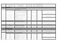
ESCAPED FIRE ANALYSIS STRATEGY<br />
Submit when fire is NOT anticipated to be BH by 1000 hrs the following day.<br />
RECORD OF OBSERVATIONS AND CURRENT FIRE BEHAVIOR<br />
1. Fire Number LWF-063 2. Date 24-may-01 3. Time 1530 hrs.<br />
4. Size (ha.) 3600 ha. + 5. Fire Origin (ATS Location) 1-26-67-2-W5<br />
6. EFAS # for this fire<br />
# 1<br />
7. Observed Fire Perimeter Behavior 30 % Crowning 10 % Candling 30 % Surface<br />
10 % Smouldering 20 % Obscured by Smoke<br />
200 M No GPS taken, as main fire caught up to spots during<br />
Spotting Distance (meters) GPS of Spots<br />
assessment period.<br />
10 Athabasca River acting as natural fire break to north and<br />
% of perimeter contained Describe<br />
(natural bariers,streams,fuel types)<br />
west sides. 40 ha. Spotfire on W side of river.<br />
8. Fire Behavior, Fuels, Topography<br />
(counter-clockwise orbit of fire starting at rear)<br />
Cardinal Direction<br />
Rear Right Flank Head Left Flank<br />
N<br />
W<br />
S<br />
E<br />
GPS Location<br />
Fuel Types Burning<br />
M1, C2, O1A (mixed)<br />
C2, M1, mix of Sb and<br />
open meadows<br />
C2, M1, mix of pine &<br />
spruce<br />
C2, open muskeg Sb, mix<br />
of pine & spruce types<br />
Fuel Ahead of Fire<br />
same - mixed fuels<br />
same - mixed fuel types<br />
same - mixed fuels<br />
same - mixed fuel types<br />
Fuel Continuity Characteristics<br />
variable, but good types<br />
next to Athabasca River<br />
variable, some<br />
intermittent C2<br />
variable, continuous in<br />
spots, roads there<br />
variable; some continuous<br />
spruce/pine types to farms<br />
ROS - Present (m/min)<br />
2 - 5<br />
5 - 10<br />
15 - 30 + 5 - 20<br />
Topography<br />
flat; slopes down to river<br />
flat, slopes down to<br />
Athabasca River<br />
flat; opens to farmland<br />
2 miles to the south<br />
flat out to farmland 2 miles<br />
to east<br />
9. Present WX Wind Dir NW Speed 20 Temp 18C RH 35 Precip nil CBs present<br />
prev<br />
Page 25 of 61