Techniques for flood hazard zonation and vulnerability ... - NDMA
Techniques for flood hazard zonation and vulnerability ... - NDMA
Techniques for flood hazard zonation and vulnerability ... - NDMA

Create successful ePaper yourself
Turn your PDF publications into a flip-book with our unique Google optimized e-Paper software.
3/17/2010<br />
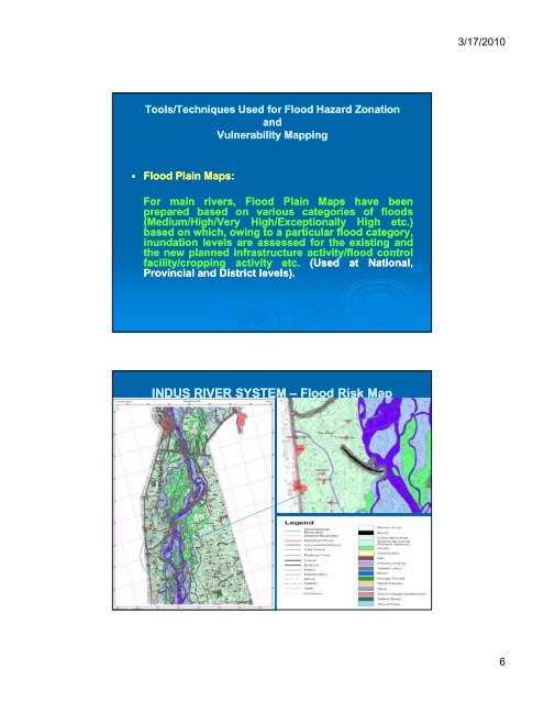
Tools/<strong>Techniques</strong> Used <strong>for</strong> Flood Hazard Zonation<br />
<strong>and</strong><br />
Vulnerability Mapping<br />
• Flood Plain Maps:<br />
For main<br />
rivers,<br />
Flood Plain<br />
Maps<br />
have<br />
been<br />
prepared based on various categories of <strong>flood</strong>s<br />
(Medium/High/Very<br />
High/Exceptionally High<br />
etc.)<br />
based on which, owing to a particular <strong>flood</strong> category,<br />
inundation levels are assessed <strong>for</strong> the existing <strong>and</strong><br />
the new planned infrastructure activity/<strong>flood</strong> control<br />
facility/cropping activity<br />
etc.<br />
(Used<br />
at<br />
National,<br />
Provincial <strong>and</strong> District levels).<br />
INDUS RIVER SYSTEM – Flood Risk Map<br />
6