Techniques for flood hazard zonation and vulnerability ... - NDMA
Techniques for flood hazard zonation and vulnerability ... - NDMA
Techniques for flood hazard zonation and vulnerability ... - NDMA

You also want an ePaper? Increase the reach of your titles
YUMPU automatically turns print PDFs into web optimized ePapers that Google loves.
3/17/2010<br />
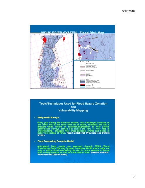
INDUS RIVER SYSTEM - Flood Risk Map<br />
Tools/<strong>Techniques</strong> Used <strong>for</strong> Flood Hazard Zonation<br />
<strong>and</strong><br />
Vulnerability Mapping<br />
• Bathymetric Surveys:<br />
Every year during the monsoon season, river discharges increase on<br />
one h<strong>and</strong> <strong>and</strong> at the same time lot of debris, sediment <strong>and</strong> silt is<br />
brought which<br />
results<br />
in accretion/degradation<br />
of<br />
river<br />
profile.<br />
Bathymetric surveys carried out across the flow of river help in<br />
underst<strong>and</strong>ing changed river cross-sectionalsectional profile <strong>and</strong> hence in<br />
better <strong>for</strong>ecasting of flows. (Used at National, Provincial <strong>and</strong> District<br />
levels).<br />
• Flood Forecasting Computer Model:<br />
Anticipated <strong>flood</strong><br />
events<br />
are<br />
assessed through<br />
FEWS<br />
(Flood<br />
Forecasting Early Warning System) Computer Model which helps not<br />
only in instant <strong>flood</strong> <strong>for</strong>ecasting but also in future estimate of <strong>flood</strong>s<br />
both at the provincial as well as at the district level. (Used at National ,<br />
Provincial <strong>and</strong> District levels).<br />
7