Carlyle Lake Final Plan.pdf - Fayette County Soil & Water ...
Carlyle Lake Final Plan.pdf - Fayette County Soil & Water ...
Carlyle Lake Final Plan.pdf - Fayette County Soil & Water ...

Create successful ePaper yourself
Turn your PDF publications into a flip-book with our unique Google optimized e-Paper software.
Socio-economic benefits of forested wetlands include flood storage, sediment control, pollution<br />
control and groundwater recharge. To the individual landowner, bottomlands can provide<br />
economic benefits in the form of timber production, recreation in the form of consumptive (i.e.<br />
hunting and trapping) and non-consumptive use of wildlife, and aesthetic values. Cost share set<br />
aside programs such as CRP and WRP make forested bottomlands, along with riparian buffers,<br />
an economically attractive option for the producer. The restoration of bottomland forest may be<br />
the single most valuable tool in maximizing the <strong>Carlyle</strong> <strong>Lake</strong> watershed’s ecological health in an<br />
economically viable context.<br />
Literature Cited<br />
Illinois Department of Energy and Natural Resources, 1994. The Changing Illinois Environment: Critical<br />
Trends. Volume 3: Ecological Resources. IL DENR, Springfield. 242 pp.<br />
Osborne, L. and D. Kovacic, 1993. Riparian vegetated buffer strips in water-quality restoration and stream<br />
management. Freshwater Biology 29: 243-258.<br />
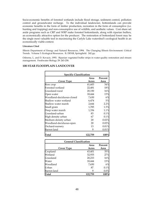
100-YEAR FLOODPLAIN LANDCOVER<br />
Specific Classification<br />
Cover Type<br />
Area<br />
Acres<br />
Percent<br />
Area<br />
Row crop 41,603 34%<br />
Forested wetland 22,481 18%<br />
Grassland-rural 20,150 16%<br />
Open water 18,444 15%<br />
Woodland-deciduous-closed 7,630 6%<br />
Shallow water wetland 6,474 5%<br />
Shallow water marsh 2,644 2.2%<br />
Small grain 1,785 1.5%<br />
Deep water marsh 1,336 1.1%<br />
Grassland-urban 83 0.1%<br />
High density urban 67 0.1%<br />
Medium density urban 20 0.02%<br />
Woodland-deciduous-open 20 0.02%<br />
Orchard-nursery 13 0.01%<br />
Barren land 9 0.01%<br />
Total 122,759 100%<br />
General Classification<br />
Cover Type<br />
Area<br />
Acres<br />
Percent<br />
Area<br />
Cropland 43,401 35%<br />
Wetland 32,935 27%<br />
Grassland 20,233 16%<br />
<strong>Water</strong> 18,444 15%<br />
Woodland 7,650 6%<br />
Urban 87 0.1%<br />
Barren land 9 0.0%<br />
Total 122,759 100%<br />
48