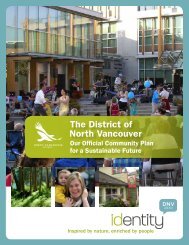
Official Community Plan - District of North Vancouver
Official Community Plan - District of North Vancouver
Official Community Plan - District of North Vancouver

Create successful ePaper yourself
Turn your PDF publications into a flip-book with our unique Google optimized e-Paper software.
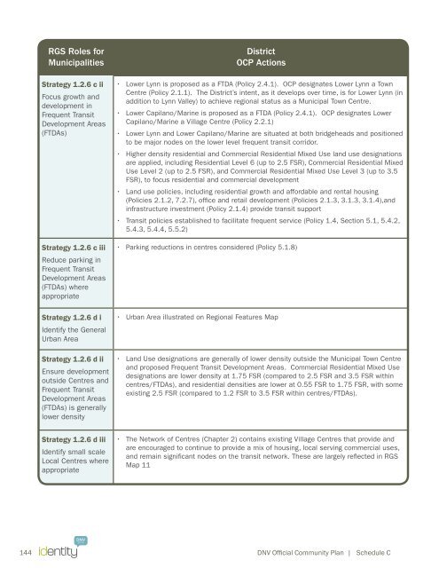
RGS Roles for<br />
Municipalities<br />
Strategy 1.2.6 c ii<br />
Focus growth and<br />
development in<br />
Frequent Transit<br />
Development Areas<br />
(FTDAs)<br />
Strategy 1.2.6 c iii<br />
Reduce parking in<br />
Frequent Transit<br />
Development Areas<br />
(FTDAs) where<br />
appropriate<br />
Strategy 1.2.6 d i<br />
Identify the General<br />
Urban Area<br />
Strategy 1.2.6 d ii<br />
Ensure development<br />
outside Centres and<br />
Frequent Transit<br />
Development Areas<br />
(FTDAs) is generally<br />
lower density<br />
<strong>District</strong><br />
OCP Actions<br />
• Lower Lynn is proposed as a FTDA (Policy 2.4.1). OCP designates Lower Lynn a Town<br />
Centre (Policy 2.1.1). The <strong>District</strong>’s intent, as it develops over time, is for Lower Lynn (in<br />
addition to Lynn Valley) to achieve regional status as a Municipal Town Centre.<br />
• Lower Capilano/Marine is proposed as a FTDA (Policy 2.4.1). OCP designates Lower<br />
Capilano/Marine a Village Centre (Policy 2.2.1)<br />
• Lower Lynn and Lower Capilano/Marine are situated at both bridgeheads and positioned<br />
to be major nodes on the lower level frequent transit corridor.<br />
• Higher density residential and Commercial Residential Mixed Use land use designations<br />
are applied, including Residential Level 6 (up to 2.5 FSR), Commercial Residential Mixed<br />
Use Level 2 (up to 2.5 FSR), and Commercial Residential Mixed Use Level 3 (up to 3.5<br />
FSR), to focus residential and commercial development<br />
• Land use policies, including residential growth and affordable and rental housing<br />
(Policies 2.1.2, 7.2.7), <strong>of</strong>fice and retail development (Policies 2.1.3, 3.1.3, 3.1.4),and<br />
infrastructure investment (Policy 2.1.4) provide transit support<br />
• Transit policies established to facilitate frequent service (Policy 1.4, Section 5.1, 5.4.2,<br />
5.4.3, 5.4.4, 5.5.2)<br />
• Parking reductions in centres considered (Policy 5.1.8)<br />
• Urban Area illustrated on Regional Features Map<br />
• Land Use designations are generally <strong>of</strong> lower density outside the Municipal Town Centre<br />
and proposed Frequent Transit Development Areas. Commercial Residential Mixed Use<br />
designations are lower density at 1.75 FSR (compared to 2.5 FSR and 3.5 FSR within<br />
centres/FTDAs), and residential densities are lower at 0.55 FSR to 1.75 FSR, with some<br />
existing 2.5 FSR (compared to 1.2 FSR to 3.5 FSR within centres/FTDAs).<br />
Strategy 1.2.6 d iii<br />
Identify small scale<br />
Local Centres where<br />
appropriate<br />
• The Network <strong>of</strong> Centres (Chapter 2) contains existing Village Centres that provide and<br />
are encouraged to continue to provide a mix <strong>of</strong> housing, local serving commercial uses,<br />
and remain significant nodes on the transit network. These are largely reflected in RGS<br />
Map 11<br />
144 DNV <strong>Official</strong> <strong>Community</strong> <strong>Plan</strong> | Schedule C