SOCET SET® brochure - BAE Systems GXP Geospatial eXploitation ...
SOCET SET® brochure - BAE Systems GXP Geospatial eXploitation ...
SOCET SET® brochure - BAE Systems GXP Geospatial eXploitation ...

You also want an ePaper? Increase the reach of your titles
YUMPU automatically turns print PDFs into web optimized ePapers that Google loves.
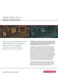
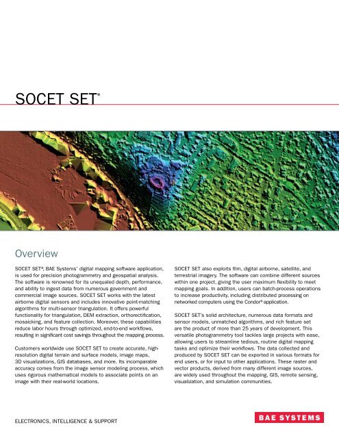
<strong>SOCET</strong> SET ®<br />
Overview<br />
<strong>SOCET</strong> SET®, <strong>BAE</strong> <strong>Systems</strong>’ digital mapping software application,<br />
is used for precision photogrammetry and geospatial analysis.<br />
The software is renowned for its unequaled depth, performance,<br />
and ability to ingest data from numerous government and<br />
commercial image sources. <strong>SOCET</strong> SET works with the latest<br />
airborne digital sensors and includes innovative point-matching<br />
algorithms for multi-sensor triangulation. It offers powerful<br />
functionality for triangulation, DEM extraction, orthorectification,<br />
mosaicking, and feature collection. Moreover, these capabilities<br />
reduce labor hours through optimized, end-to-end workflows,<br />
resulting in significant cost savings throughout the mapping process.<br />
Customers worldwide use <strong>SOCET</strong> SET to create accurate, highresolution<br />
digital terrain and surface models, image maps,<br />
3D visualizations, GIS databases, and more. Its incomparable<br />
accuracy comes from the image sensor modeling process, which<br />
uses rigorous mathematical models to associate points on an<br />
image with their real-world locations.<br />
<strong>SOCET</strong> SET also exploits film, digital airborne, satellite, and<br />
terrestrial imagery. The software can combine different sources<br />
within one project, giving the user maximum flexibility to meet<br />
mapping goals. In addition, users can batch-process operations<br />
to increase productivity, including distributed processing on<br />
networked computers using the Condor®application.<br />
<strong>SOCET</strong> SET’s solid architecture, numerous data formats and<br />
sensor models, unmatched algorithms, and rich feature set<br />
are the product of more than 25 years of development. This<br />
versatile photogrammetry tool tackles large projects with ease,<br />
allowing users to streamline tedious, routine digital mapping<br />
tasks and optimize their workflows. The data collected and<br />
produced by <strong>SOCET</strong> SET can be exported in various formats for<br />
end users, or for input to other applications. These raster and<br />
vector products, derived from many different image sources,<br />
are widely used throughout the mapping, GIS, remote sensing,<br />
visualization, and simulation communities.<br />
ELECTRONICS, INTELLIGENCE & SUPPORT
Multiple sensors<br />
−−<strong>SOCET</strong> SET supports multiple image sources with an unrivaled range of data formats.<br />
−−Satellite image sources: WorldView-1, QuickBird, EROS B, FORMOSAT-2, IKONOS®, OrbView-3, SPOT, LANDSAT, Radarsat, NTM,<br />
ALOS PRISM, TerraSAR-X, COSMO-SkyMed, and others; new sensor models added with each release.<br />
−−Airborne image sources from scanned film and digital imagery: ADS40, DMC, DSS, UltraCam, and most other aerial frame and<br />
panoramic sensors.<br />
−−Native image formats: <strong>SOCET</strong> SET recognizes leading image formats such as: TIFF, NITF, JPEG 2000, JPEG, and GeoTIFF.<br />
−−Simultaneous use of multiple sensors, sensor models, and associated image formats for exploitation, triangulation, and product generation.<br />
From left to right: WorldView-1 stereo pair in NCDRD format and QuickBird Basic Image, courtesy of DigitalGlobe; IKONOS pan-sharpened RPC image, courtesy of GeoEye®.<br />
Triangulation and point measurement<br />
<strong>SOCET</strong> SET has a precise image control process that allows for incomparable accuracy<br />
−−Rigorous mathematical models are used to associate points on an image with their real-world locations.<br />
−−The Automatic Point Measurement (APM) module allows for tie points to be generated and measured with unmatched speed and<br />
accuracy, even in conditions where multi-sensor or multi-temporal imagery is used.<br />
−−The Interactive Point Measurement module allows manual and semi-automatic measurement of tie, control, and check points with<br />
multiple viewports, including stereo.<br />
−−The Multi-Sensor Triangulation module enables simultaneous image registration by adjusting image metadata from multiple sources<br />
for exceptional speed and accuracy.<br />
−−Satellite ephemeris metadata and airborne GPS/IMU data aid the image control process.<br />
Multiple image display for manual and semi-automatic point measurement and review, including graphics for diagnosis of the overall triangution solution.
Terrain and surface modeling<br />
Create digital terrain models (DTM) and digital surface models (DSM) automatically with numerous tools for editing<br />
and quality assurance<br />
Input and output terrain sources<br />
−−<strong>SOCET</strong> SET can import DTED®, ASCII, ArcGrid®, GeoTIFF, NITF,<br />
LAS LIDAR, GSI, Intermap BIL, USGS DEM, NED, and SDTS formats.<br />
−−Terrain database accommodates billions of points; suited to<br />
LIDAR data or photogrammetrically derived terrain models.<br />
−−Generates LIDAR intensity images during import.<br />
Automatic Terrain Extraction (ATE) module<br />
Provides a fully automated capability to extract elevation data<br />
from stereo imagery.<br />
Next-Generation Automatic Terrain Extraction (NGATE) module<br />
Technically advanced module for automatic DTM/DSM<br />
generation featuring radical new algorithms based on a<br />
combination of area and edge matching; allows for terrain and<br />
surface modeling down to the image pixel level.<br />
−−Each pixel is matched many times, resulting in a dense and<br />
accurate point cloud which resembles LIDAR data.<br />
−−Simultaneous creation of DTMs/DSMs.<br />
−−Uses breaklines and mass points in a triangulated irregular<br />
network (TIN) data storage format.<br />
Interactive Terrain Editor (ITE) module<br />
Enables users to visualize and correct elevation models with an<br />
unsurpassed set of tools and graphical display of choices using<br />
stereo imagery.<br />
−−Adaptive tools for TIN and grid data storage formats.<br />
−−Point, geomorphic line, and area tools.<br />
−−Huge range of bare-earth tools for removal of trees and<br />
buildings for productive generation of DTMs from DSMs.<br />
−−All tools applicable to LIDAR point clouds or<br />
photogrammetrically derived DSMs.<br />
DTM<br />
DSM<br />
Terrain/Feature Merge module<br />
Combines multiple elevation data sets and optional vector data<br />
into a single output file in either TIN or grid data storage format.<br />
Quality assurance<br />
Statistical comparison of DTMs and DSMs with control source<br />
points or other DTMs/DSMs.<br />
NGATE creates DTMs/DSMs simultaneously. Top and center image pairs<br />
courtesy of AAMHatch. Bottom image pair courtesy of HJW GeoSpatial.<br />
One-meter DSMs created using NGATE from 0.5 m GSD WorldView-1 stereo imagery. Both models are of the same area; image on left is a perspective view of<br />
part of the terrain shaded relief image on the right.
Feature collection and update<br />
Interactive vector extraction for ESRI® ArcGIS® or stand-alone environments with tools for enhanced productivity<br />
<strong>SOCET</strong> for ArcGIS (SFA)®module: <strong>SOCET</strong> SET photogrammetric<br />
accuracy and stereoscopic viewing combined with data<br />
extraction within the ArcGIS environment<br />
−−3D information is captured directly in the ESRI® environment<br />
with the <strong>SOCET</strong> SET connection to ArcMap®.<br />
−−Choice of using ArcMap or <strong>SOCET</strong> SET Sketch tools for 3D<br />
feature collection.<br />
−−Manual and automatic attribution.<br />
−−SFA/ArcMap interface allows connection with the geodatabase,<br />
whether personal or multi-user, and allows for versioning.<br />
−−Products produced for general public use: planimetric data,<br />
utilities infrastructure and inventory, resource management<br />
geodatabases, land management geodatabases, emergency<br />
planning geodatabases.<br />
−−Products produced for defense customers: NGA products<br />
such as urban feature data, topographic line maps, lines of<br />
communication, digital, aeronautical, and flip charts.<br />
Feature Extraction module: vector capture and attribution<br />
−−3D information is captured into a <strong>SOCET</strong> SET feature database<br />
using <strong>SOCET</strong> SET Sketch tools.<br />
−−Manual and automatic attribution.<br />
−−Import/export: shapefiles, DXF or ASCII.<br />
−−Volumetric feature extraction: Easy-to-use tools for creating<br />
common building roof types and for loading terrain — buildings<br />
can be rendered into visualization/simulation packages with<br />
texturing applied during <strong>SOCET</strong> SET OpenFlight export.<br />
UrbanModeler module: designed specifically for creating<br />
volumetric 3D urban models<br />
−−Templates and cue cards streamline 3D collection.<br />
−−Special volumetric topology tools: snap to roof, grouping, snap<br />
to face, and vertex sharing.<br />
−−3D viewer dynamically updates with edits.<br />
−−Visual attribution.<br />
−−Export to OpenFlight, <strong>SOCET</strong> SET feature database, and shapefiles.<br />
<strong>SOCET</strong> SET Sketch tools are used internally for <strong>SOCET</strong> SET Feature Extraction, Seamline Editing, and Interactive Terrain Extraction, as well as externally in SFA<br />
allowing expanded capability for ArcMap by providing enhanced 3D extraction and editing capabilities.<br />
<strong>SOCET</strong> for ArcGIS. IKONOS image courtesy of GeoEye®.
Ortho and image products<br />
The Ortho module offers flexible, efficient functionality for producing color-balanced orthophotos and broad area mosaics<br />
Orthomosaic<br />
Create sheets or large area coverage orthomosaic products.<br />
−−Automatic seamline options.<br />
−−Image balance correction for brightness and contrast<br />
variations due to hot spots, vignetting, differences in scanner<br />
quality or settings, different film types, and images acquired at<br />
different times of the day or year.<br />
−−Color matching using band ratios, localized corrections and<br />
global balancing.<br />
−−Pixel void fill.<br />
−−Feathering and smoothing operations applied along seamlines.<br />
−−Seamline editing.<br />
True orthophoto<br />
Corrects for displacements of buildings, bridges, or other<br />
surfaces caused by features not lying on the terrain surface.<br />
Ortho-stereomate<br />
Creates a stereomate for an orthophoto with options for<br />
creating left or right stereomate and the amount of vertical<br />
exaggeration, thus allowing stereo visualization of an orthophoto.<br />
Orthophoto pansharpening<br />
Allows low-resolution color images to be merged with highresolution<br />
panchromatic images, resulting in a colorized, highresolution<br />
orthophoto.<br />
Change detection<br />
Two raw images can be compared with input terrain for proper<br />
pixel registration, resulting in a finished, orthorectified image<br />
with changes highlighted.<br />
From left, raw and color-balanced orthomosaics of approximately 300 digital frame images.<br />
Scene visualization<br />
<strong>SOCET</strong> SET terrain and feature datasets can be exported for use in many commercial, real-time visual simulation<br />
applications by using the OpenFlight output capability<br />
−−OpenFlight output exports <strong>SOCET</strong> SET database files in the MultiGen OpenFlight format.<br />
• Supports multiple levels of detail, degrees of freedom, and sound — both within a file and to external files — replication,<br />
animation sequences, bounding volumes for real-time culling, scene lighting features, light points and light point strings,<br />
transparency, texture mapping, material properties, and other features.<br />
−−<strong>SOCET</strong> SET database files can consist of any combination of feature data, terrain data, or image data.<br />
−−Features and terrain are automatically textured with imagery using ray-tracing techniques for determining the “best” image for texturing.<br />
• True orthos are best used for texturing terrain.<br />
• Off-nadir imagery is best used for texturing buildings.<br />
−−Option for exporting shapefiles with associated project file (*.prj), which contains datum and coordinate system information.
Stereo IKONOS image pair with superimposed graphics identifying areas<br />
of interest for interactive extraction and attribution of vertical obstructions.<br />
IKONOS images courtesy of GeoEye.<br />
Two perspective runway views showing the NGATE-derived surface model<br />
draped over the IKONOS image (left) and as a grayscale shaded relief image.<br />
IKONOS images courtesy of GeoEye.<br />
ClearFlite ® module<br />
Vertical obstruction identification for airfields<br />
−−Documents features and vertical obstructions that could<br />
cause safety problems for aircraft.<br />
−−Enables viewing of zones and obstruction surfaces to identify<br />
objects penetrating above the stereoscopic imagery.<br />
−−Identifies zones and obstruction surfaces for different<br />
governing agencies such as the FAA, NGA, and ICAO.<br />
−−Automatically creates surfaces and performs obstacle analysis for:<br />
• FAA TERPS Part 77.<br />
• FAA, ANA.<br />
• ICAO PANS-OPS.<br />
• Specialized surfaces for government and military customers.<br />
−−Automatically identifies obstructions that penetrate the various<br />
obstruction surfaces using DSM from sources such as NGATE<br />
and LIDAR.<br />
−−Manual collection and editing of 3D volumetric features, points,<br />
lines, and polygons using visual cues from stereo and cursor color<br />
for data above or below the Obstruction Identification Surface.<br />
Additional products<br />
−−DataThruWay®(DTW): import and sensor modeling for<br />
government image sources.<br />
−−DPPDB Format Production Module*: generate DPPDB-like<br />
products from NTM or commercial sources.<br />
−−CIB Format Production Module*: generate CIB-like products<br />
from NTM or commercial sources.<br />
−−Mapping, charting, and geodetic feature specifications for<br />
extraction and attribution of features consistent with the<br />
Feature Attribute Coding Catalog to support mapping products<br />
such as Topographic Line Maps and City Graphic.<br />
Additional highlights<br />
−−Condor distributed processing for reduced-resolution dataset<br />
generation, ATE, NGATE, and Mosaic, as well as specific<br />
functions for DPPDB-like and CIB-like generation.<br />
−−Developer’s Toolkit (DevKit) lets users write custom scripts;<br />
plug-in sensor models allow third-party developers to integrate<br />
multiple custom sensor models with <strong>SOCET</strong> SET.<br />
−−Integrated with VrOne® from Cardinal <strong>Systems</strong>, LLC for<br />
vector collection, editing, batch processing, and translation<br />
to popular vector formats such as DGN and DXF.<br />
−−Integrated with BINGO for frame imagery triangulation;<br />
extremely efficient with very large projects — capable of<br />
processing blocks of more than 20,000 photos; supports<br />
GPS/IMU self-calibration; extensive tools for graphical<br />
analysis and blunder elimination.<br />
−−Batch-processing capabilities for many modules such as APM,<br />
ATE, NGATE, Ortho, and Dodger.<br />
−−Rectifies on the fly.<br />
−−Supports PC (Microsoft® Windows® XP, Vista®**) and UNIX®<br />
(Sun Microsystems®Solaris 10).<br />
−−Multiple license servers can be defined for query by<br />
<strong>SOCET</strong> SET applications.<br />
−−Documentation: user’s manual, sysadmin manual, online<br />
help system, Web discussion forums.<br />
−−First-class support engineers, available via e-mail, telephone,<br />
or fax; online access to all patches and product information;<br />
training classes at our facilities or yours.<br />
* <strong>SOCET</strong> SET Digital Point Positioning Data Base (DPPDB) format production<br />
module [which uses MIL-PRF-89034, March 1999 format specifi cations] and<br />
<strong>SOCET</strong> SET Controlled Image Base® (CIB) format production module [which<br />
uses MIL-PRF-89041, 15 May 1999 format specifications]<br />
** Effective May 2008, Microsoft Vista does not support quad-buffered<br />
stereo, which is used by <strong>SOCET</strong> SET for stereo viewing
<strong>SOCET</strong> <strong>GXP</strong> ®<br />
The union of image analysis, geospatial analysis, photogrammetry, and mapping within a single product<br />
In keeping with <strong>BAE</strong> <strong>Systems</strong>’ vision that analysis and mapping tasks are merging into a single market, <strong>SOCET</strong> SET’s photogrammetric<br />
strength is being integrated into one end-to-end software package. <strong>SOCET</strong> <strong>GXP</strong>® combines image analysis and geospatial production<br />
(photogrammetry) tools into one flexible, user-friendly software package.<br />
Today, image analysts need the capability to extract accurate geospatial information, while geospatial analysts and mapping<br />
professionals require increased ease of use and additional analysis tools. <strong>BAE</strong> <strong>Systems</strong> has listened to existing and prospective users<br />
who must learn and operate as many as six different software products — and organizations and commands are looking for time and<br />
cost savings across the board. This new product architecture, the foundation for the comprehensive <strong>SOCET</strong> <strong>GXP</strong> application, addresses<br />
these issues.<br />
<strong>SOCET</strong> <strong>GXP</strong> captures the geospatial production strengths of <strong>SOCET</strong> SET, which reflects more than more than 1,000 labor years of<br />
development. The <strong>SOCET</strong> <strong>GXP</strong> architecture is scalable and highly configurable so that customers can buy specific functionality for their<br />
requirements. Like <strong>SOCET</strong> SET, <strong>SOCET</strong> <strong>GXP</strong> offers the same appearance, performance, user experience, and software baseline for UNIX<br />
and Windows, ensuring ease of use among multiple workstations.<br />
Transitioning from <strong>SOCET</strong> SET to <strong>SOCET</strong> <strong>GXP</strong><br />
Current <strong>SOCET</strong> SET customers already benefit from an integrated suite of tools to manage their geospatial information infrastructure.<br />
<strong>SOCET</strong> <strong>GXP</strong> is the next-generation software suite that incorporates the latest technology, user feedback, and top-notch support to get<br />
customers up and running quickly.<br />
Users who have not yet transitioned to <strong>SOCET</strong> <strong>GXP</strong> can run both systems until it is convenient to migrate to the new product.<br />
<strong>SOCET</strong> SET customers with current Upgrade Entitlement automatically receive a copy of <strong>SOCET</strong> <strong>GXP</strong>.<br />
Implementing a new system involves a significant investment in time and resources. <strong>BAE</strong> <strong>Systems</strong> will provide patches and technical<br />
support for <strong>SOCET</strong> SET during the transition period. Using intuitive tools and shortcuts for most tasks, customers realize the benefits<br />
immediately. New users have expressed overwhelming satisfaction with <strong>SOCET</strong> <strong>GXP</strong>’s intuitive interface and automated, pushbutton<br />
functionality for complex processing steps, all of which contribute to efficient workflows and significant time savings.<br />
Foundation for the future<br />
<strong>SOCET</strong> <strong>GXP</strong> offers a solid foundation users can build on well into the future as requirements change and organizations evolve. By<br />
implementing an advanced technology infrastructure, <strong>BAE</strong> <strong>Systems</strong> is empowering organizations to embrace a long-term solution that<br />
consolidates resources, reduces operating and maintenance costs, and increases productivity.
For more information on <strong>BAE</strong> <strong>Systems</strong> and <strong>GXP</strong> products:<br />
Americas<br />
Telephone 800 316 9643 | 703 668 4385<br />
Fax 703 668 4381<br />
socetgxp.sales@baesystems.com<br />
Europe, Middle East, and Africa<br />
Telephone +44 1223 370023<br />
Fax +44 1223 370040<br />
socetgxp.emea.sales@baesystems.com<br />
Asia, Australia, and Pacific-Rim<br />
Telephone +61 0 2 6273 0111<br />
Fax +61 0 2 6273 0368<br />
socetgxp.asia.sales@baesystems.com<br />
For additional contact information and worldwide distributors, please visit our Web site:<br />
www.baesystems.com/gxp<br />
© 2008 <strong>BAE</strong> <strong>Systems</strong> National Security Solutions Inc. All rights reserved. All trademarks used are property of their respective owners.<br />
2610071508B EXPORT-CONTROLLED DATA: These commodities, technology, or software are controlled for export in accordance with the<br />
U.S. export laws. Diversion contrary to U.S. law is prohibited. Release of this <strong>brochure</strong> is approved as of 07/15/2008. This document<br />
gives only a general description of the product(s) or service(s) offered by <strong>BAE</strong> <strong>Systems</strong> and, except where expressly provided otherwise,<br />
shall not form part of any contract. From time to time, changes may be made in the products or conditions of supply.