SOCET SET® brochure - BAE Systems GXP Geospatial eXploitation ...
SOCET SET® brochure - BAE Systems GXP Geospatial eXploitation ...
SOCET SET® brochure - BAE Systems GXP Geospatial eXploitation ...

Create successful ePaper yourself
Turn your PDF publications into a flip-book with our unique Google optimized e-Paper software.
Terrain and surface modeling<br />
Create digital terrain models (DTM) and digital surface models (DSM) automatically with numerous tools for editing<br />
and quality assurance<br />
Input and output terrain sources<br />
−−<strong>SOCET</strong> SET can import DTED®, ASCII, ArcGrid®, GeoTIFF, NITF,<br />
LAS LIDAR, GSI, Intermap BIL, USGS DEM, NED, and SDTS formats.<br />
−−Terrain database accommodates billions of points; suited to<br />
LIDAR data or photogrammetrically derived terrain models.<br />
−−Generates LIDAR intensity images during import.<br />
Automatic Terrain Extraction (ATE) module<br />
Provides a fully automated capability to extract elevation data<br />
from stereo imagery.<br />
Next-Generation Automatic Terrain Extraction (NGATE) module<br />
Technically advanced module for automatic DTM/DSM<br />
generation featuring radical new algorithms based on a<br />
combination of area and edge matching; allows for terrain and<br />
surface modeling down to the image pixel level.<br />
−−Each pixel is matched many times, resulting in a dense and<br />
accurate point cloud which resembles LIDAR data.<br />
−−Simultaneous creation of DTMs/DSMs.<br />
−−Uses breaklines and mass points in a triangulated irregular<br />
network (TIN) data storage format.<br />
Interactive Terrain Editor (ITE) module<br />
Enables users to visualize and correct elevation models with an<br />
unsurpassed set of tools and graphical display of choices using<br />
stereo imagery.<br />
−−Adaptive tools for TIN and grid data storage formats.<br />
−−Point, geomorphic line, and area tools.<br />
−−Huge range of bare-earth tools for removal of trees and<br />
buildings for productive generation of DTMs from DSMs.<br />
−−All tools applicable to LIDAR point clouds or<br />
photogrammetrically derived DSMs.<br />
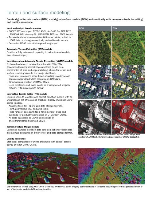
DTM<br />
DSM<br />
Terrain/Feature Merge module<br />
Combines multiple elevation data sets and optional vector data<br />
into a single output file in either TIN or grid data storage format.<br />
Quality assurance<br />
Statistical comparison of DTMs and DSMs with control source<br />
points or other DTMs/DSMs.<br />
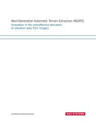
NGATE creates DTMs/DSMs simultaneously. Top and center image pairs<br />
courtesy of AAMHatch. Bottom image pair courtesy of HJW GeoSpatial.<br />
One-meter DSMs created using NGATE from 0.5 m GSD WorldView-1 stereo imagery. Both models are of the same area; image on left is a perspective view of<br />
part of the terrain shaded relief image on the right.