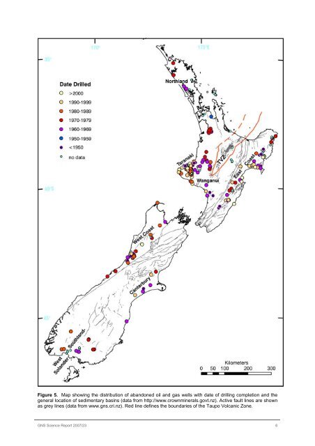
Figure 5. Map showing the distribution of abandoned oil and gas wells with date of drilling completion and the general location of sedimentary basins (data from http://www.crownminerals.govt.nz). Active fault lines are shown as grey lines (data from www.gns.cri.nz). Red line defines the boundaries of the Taupo Volcanic Zone. <strong>GNS</strong> <strong>Science</strong> <strong>Report</strong> 2007/23 6
The onshore wells were drilled from 1866 to 2005 with the two late-19th century ones located in Taranaki (Figure 5). The completion dates of 93 wells are unknown. Of those with known dates, 19 wells drilled from 1903-1944 are located in Taranaki, 16 in the East Coast of North Island, two in the Wanganui basin, 15 in the West Coast of South Island and one in Canterbury. These were drilled to depths of 19 to 3331m. Thirty-four wells were drilled before 1970, 33 before 1980, 68 before 1990, 41 from 1990-1999 and 27 after 2000. The date of completion nearly a century ago does not preclude development. For example, Bonithon-1, a well used today for the Taranaki baths in New Plymouth was drilled in 1908. However, Bonithon-2 sited nearby and drilled nearly at the same time could not be located. Well diameters below the production casing shoe range from about 2.5” to 12”. A liner is sometimes installed and sometimes perforated. However, the liner is retrieved prior to abandoning the wells. Hence the age of the boreholes may, however, affect the degree of cave-ins in wells without liners. 3.2 WELL DEPTHS AND ESTIMATED BOTTOM HOLE TEMPERATURES Abandoned wells have total vertical depths ranging from 17m to 5064m (Figure 6). Twelve of the 13 wells drilled deeper than 4000m are located in Taranaki e.g., Inglewood-1 (5061m) and Cardiff-1 (5064m). The one well deeper than 4000m outside Taranaki is located in the East Coast i.e., Rere-1 (4351m; Figure 2). Down hole temperatures, after the well had stabilised after drilling, are often not measured in hydrocarbon wells although temperatures during or just a few hours after drilling have been measured in some wells. Since stable downhole temperatures are not available for most wells, bottom hole temperatures are roughly estimated using published surface conductive heat flow data (Funnell et al, 1996; King and Thrasher, 1996; Funnell and Allis, 1997; Field et al, 1997; Allis et al, 1998, Cook et al, 1999) and converted to thermal gradient, in o C/km, using a factor of 2.1 (Funnell, pers. comm., 2003) and an average surface temperature of 15 o C. In two wells, Kowai-1 and Hohonu-1, the bottom temperatures measured a few hours after drilling are higher by 8 o C and 3 o C, respectively than calculated bottomhole temperatures, i.e., 60 o C vs 52 o C for Hohonu-1 and 52 o C vs 49 o C for Kowai-1. Thus calculated bottomhole temperatures are most likely minimum values. Homogenisation temperatures in the latest aqueous fluid inclusions in quartz in abandoned and active hydrocarbon wells in Taranaki are often about +10 o C of the estimated bottomhole temperatures (Reyes unpublished data, Reyes, 1998). The estimated bottomhole temperatures in the onshore abandoned hydrocarbon wells range from ambient to as high as 172 o C at 4451m in well New Plymouth-2 in Taranaki (Figures 7 and 8; Table 1). About 34% of all the onshore wells (120) have bottom hole temperatures of