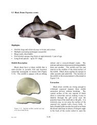
Basic Commercial Fishing Regulations - Gulf States Marine ...
Basic Commercial Fishing Regulations - Gulf States Marine ...
Basic Commercial Fishing Regulations - Gulf States Marine ...

Create successful ePaper yourself
Turn your PDF publications into a flip-book with our unique Google optimized e-Paper software.
Saltwater - Freshwater Line<br />
For complete requirements regarding the taking of<br />
fish in federal waters obtain a <strong>Commercial</strong> <strong>Fishing</strong><br />
<strong>Regulations</strong> for <strong>Gulf</strong> of Mexico Federal Waters<br />
pamphlet from the <strong>Gulf</strong> of Mexico Fishery<br />
Management Council:<br />
2203 N. Lois Avenue, Suite 1100<br />
Tampa, FL 33607<br />
Phone: 813-348-1630.<br />
E-mail: gulfcouncil@gulfcouncil.org.<br />
Web: www.gulfcouncil.org<br />
For the purposes of regulating certain fisheries the<br />
legislature recognized the historic division of the state<br />
into saltwater and freshwater areas based on the variations<br />
of flora and fauna found within these two divisions.<br />
The legislature further recognized that the exact<br />
line of demarcation cannot be precisely located due to<br />
constant changes in water salinity caused by winds,<br />
tides, and rains. The legislature therefore legally<br />
defined the freshwater and saltwater areas by describing<br />
a line from the Texas state line, easterly to the<br />
Mississippi state line. The areas south of the described<br />
line, plus a number of saltwater lakes and waterways,<br />
were designated as saltwater areas and all other areas<br />
north of the described line were designated as freshwater<br />
areas.<br />
Louisiana Saltwater Line Definition<br />
Title 56, Section 322 - The Intracoastal waterway<br />
from the Texas-Louisiana boundary to its junction<br />
with Louisiana Highway 27 at Gibbstown, and then<br />
south to Louisiana Highway 82 and then east to its<br />
junction with the Intracoastal Waterway at Forked<br />
Island, the Intracoastal Waterway from Forked Island<br />
to Bayou Barataria to the Harvey Canal, the Harvey<br />
Canal to the Mississippi River, the Mississippi River<br />
to the Industrial Canal, the Industrial Canal to the<br />
Intracoastal Waterway, the Intracoastal Waterway to<br />
the Rigolets in Orleans Parish to the Louisville &<br />
Nashville Railroad bridge, the Louisville & Nashville<br />
Railroad right-of-way from the Orleans Parish line to<br />
the Mississippi state line.<br />
Notwithstanding any other provision of law to the<br />
contrary, the waters of the Intracoastal Waterway in<br />
Orleans Parish from the overhead power lines at the<br />
Interharbor Navigation Canal east to the Rigolets shall<br />
be considered both salt and fresh water for the purposes<br />
of authorizing the taking or possessing fish or<br />
the use or possession of gear. <strong>Commercial</strong> fishing<br />
operations in these waters shall not interfere with normal<br />
commercial traffic.<br />
The areas south of the above described line, plus<br />
the saltwater lakes known as Sabine Lake, Calcasieu<br />
Lake, including that portion of the Calcasieu Ship<br />
Channel which actually adjoins Calcasieu Lake, West<br />
and East Pass of the Calcasieu River and Oyster Bayou<br />
in Cameron Parish, Lake Maurepas, Lake Pontchartrain,<br />
Lake St. Catherine, Chef Menteur Pass (except that<br />
seven-tenths of a mile section from Bayou Sauvage<br />
south to the Intercoastal Waterway), the Rigolets,<br />
Unknown Pass, Pass Manchac, and that portion of the<br />
Calcasieu Ship Channel from the Intracoastal Waterway<br />
south to the <strong>Gulf</strong> of Mexico, shall be designated as<br />
saltwater areas.<br />
16<br />
114