Village of Folsom, LA
Village of Folsom, LA
Village of Folsom, LA

Create successful ePaper yourself
Turn your PDF publications into a flip-book with our unique Google optimized e-Paper software.
Following the 1878 outbreak <strong>of</strong> Yellow Fever in New Orleans, many<br />
residents fled to the Northshore and to what were believed to be<br />
the healing powers <strong>of</strong> the ozone waters. It was during this time<br />
that the US government declared St. Tammany Parish to be the 2 nd<br />
healthiest place to live in the country, having so few deaths from<br />
Yellow Fever and Malaria that physicians thought the quality <strong>of</strong> the<br />
air and water helped prevent or cure these diseases.<br />
Incorporation <strong>of</strong> <strong>Folsom</strong><br />
By 1880, the area that is now the <strong>Village</strong> <strong>of</strong> <strong>Folsom</strong> was occupied by<br />
several families. As recorded in the 1880 United State Census,<br />
adults in <strong>Folsom</strong> were listed either as farmers or a housewives. At<br />
the time St. Tammany continued to be mostly virgin forestland and<br />
land used for cultivating crops. The parish was traversed by trading<br />
routes, including Holmesville Road, which were dirt roads that were<br />
maintained by the St. Tammany Police Jury. Police Juries were the<br />
form <strong>of</strong> local government at the time and semi-annual meetings<br />
were held in January and July. Often, the Jury would wait 3-4 days<br />
before a quorum was present to being the meetings and meetings<br />
would last up to 6 days.<br />
Land in the area was available for homesteading under the<br />
Recovery and Reclaims Acts <strong>of</strong> 1855 and 1857, averaging about<br />
$1.25 per acre. Between 1868 and 1886, over 3,200 new acres <strong>of</strong><br />
land were homesteaded, in 1887 another 2,500 acres <strong>of</strong> land, and<br />
between 1888 and 1897, another 4,000 acres <strong>of</strong> land was<br />
homesteaded in the <strong>Folsom</strong> area v . Amidst this growth in new<br />
landowners, Native American tribes still lived and traded.<br />
It was in 1904, when George M. Fendlason and his brother Hines<br />
Norman filed for a plat <strong>of</strong> survey, that <strong>Folsom</strong> became a village.<br />
Since it became a village, <strong>Folsom</strong> has been known for its towering<br />
pines and its rolling hills. <strong>Folsom</strong> earned its name from President<br />
Grover Cleveland’s wife, Frances <strong>Folsom</strong> Cleveland, an icon for<br />
working women at the time. One <strong>of</strong> the first lots was sold in<br />
<strong>Folsom</strong> in November 1904.<br />
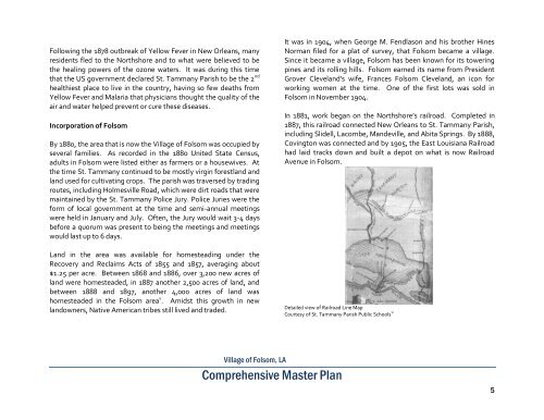
In 1881, work began on the Northshore’s railroad. Completed in<br />
1887, this railroad connected New Orleans to St. Tammany Parish,<br />
including Slidell, Lacombe, Mandeville, and Abita Springs. By 1888,<br />
Covington was connected and by 1905, the East Louisiana Railroad<br />
had laid tracks down and built a depot on what is now Railroad<br />
Avenue in <strong>Folsom</strong>.<br />
Detailed view <strong>of</strong> Railroad Line Map<br />
Courtesy <strong>of</strong> St. Tammany Parish Public Schools vi<br />
<strong>Village</strong> <strong>of</strong> <strong>Folsom</strong>, <strong>LA</strong><br />
Comprehensive Master Plan<br />
5