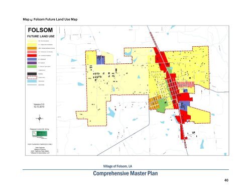
Institutional (IS) Institutional land uses serve the religious, municipal, and educational needs <strong>of</strong> the community and include, but are not limited to, educational facilities, places <strong>of</strong> worship, hospitals, community centers, libraries, municipal infrastructure facilities, and civic/government buildings and the administrative support for each use. In <strong>Folsom</strong>, the two public schools, the library, and the Town Hall are identified as Institutional. Some small-scale institutional uses such as small churches, small community facilities, and daycare facilities might not be identified as Institutional uses because they are considered compatible and complimentary to residential uses. Industrial (ID) This land use category includes a wide range <strong>of</strong> employmentgenerating <strong>of</strong>fice, light industrial, manufacturing, processing, and warehousing uses. In <strong>Folsom</strong> no areas for Industrial land use are currently identified. However if in the future there is Industrial land use those areas should have adequate buffering and design standards that limit the negative impacts <strong>of</strong> the uses on the adjacent land uses and the community as a whole. Parks and Open Space (P) Areas that include public and private recreational activities, as well as environmental preservation needs. In <strong>Folsom</strong>, Parks and Open Space areas would include parks, playgrounds, recreation centers, golf courses, wildlife refuges, and land reserved for environmental preservation and conservation. Within these land use areas, there may also be the provision <strong>of</strong> car parking facilities, as well as ancillary buildings and structures required for operating and maintaining the park or open space. <strong>Folsom</strong> Future Land Use Map Generally, a Future Land Use Map only identifies areas within the community’s <strong>of</strong>ficial limits. However, because <strong>of</strong> the anticipated growth <strong>of</strong> <strong>Folsom</strong> over the next 20 years and the current growth management agreement that specifies areas where <strong>Folsom</strong> can annex property, two Future Land Use Maps are included in this plan. Map 4 is a Future Land Use map that identifies Future Land Use in the current <strong>Folsom</strong> municipal boundaries. Map 5 is a Regional Future Land Use Map that not only includes the current <strong>Folsom</strong> municipal boundaries, but also areas within the <strong>Folsom</strong> St. Tammany Parish growth management annexation boundary. <strong>Village</strong> <strong>of</strong> <strong>Folsom</strong>, <strong>LA</strong> Comprehensive Master Plan 39
Map 4: <strong>Folsom</strong> Future Land Use Map <strong>Village</strong> <strong>of</strong> <strong>Folsom</strong>, <strong>LA</strong> Comprehensive Master Plan 40
- Page 1 and 2: Village of Folsom, LA traci a Compr
- Page 3 and 4: This Page Intentionally Left Blank
- Page 5 and 6: List of Tables Table 1: Village of
- Page 7 and 8: Map 1: Folsom 2009 Aerial Map Villa
- Page 9 and 10: and British rebels who resented Spa
- Page 11 and 12: During this time, the principle cro
- Page 13 and 14: The virgin forests surrounding Fols
- Page 15 and 16: Local horse farms have contributed
- Page 17 and 18: III. EXISTING CONDITIONS A. Populat
- Page 19 and 20: Table 5: Comparative Age Characteri
- Page 21 and 22: C. Income, Employment and Economy T
- Page 23 and 24: Table 14: Most Common Occupations f
- Page 25 and 26: E. Community Administrative Staff,
- Page 27 and 28: Folsom Elementary School Folsom Ele
- Page 29 and 30: v Council on Aging St. Tammany Pari
- Page 31 and 32: Folsom - St. Tammany Parish Growth
- Page 33 and 34: i St. Tammany Parish Council Ordina
- Page 35 and 36: Residential Area Challenges: Lack o
- Page 37 and 38: July 29, 2010 August 24, 2010 Septe
- Page 39 and 40: V. Plan for the Future Introduction
- Page 41 and 42: Economic Development Folsom’s eco
- Page 43: Single Family Residential (SF) Low
- Page 47 and 48: B. TRANSPORTATION The completion of
- Page 49 and 50: emergency lane would taper off and
- Page 51 and 52: Transportation Strategic Recommenda
- Page 53 and 54: Connectivity to Magnolia Park Magno
- Page 55 and 56: Map 7: Suggested Water and Sewer Im
- Page 57 and 58: Sewer System General Characteristic
- Page 59 and 60: D. COMMUNITY FACILITY NEEDS In the
- Page 61 and 62: A new Senior Center in Folsom shoul
- Page 63 and 64: Table 25: Trends for Dwelling Units
- Page 65 and 66: Housing Strategic Recommendations 1
- Page 67 and 68: F. AGRICULTURAL AND NATURAL RESOURC
- Page 69 and 70: limitations for such uses. Further,
- Page 71 and 72: Flatwoods and Southern Coastal Plai
- Page 73 and 74: 3) Work with State and regional age
- Page 75 and 76: G. ECONOMIC DEVELOPMENT Introductio
- Page 77 and 78: office space, just a fraction of th
- Page 79 and 80: Strategy 2: Update Comprehensive Zo
- Page 81 and 82: H. REGIONAL GROWTH AND COOPERATION
- Page 83 and 84: V. Implementation The Plan for the
- Page 85 and 86: Is there current pressure for immin
- Page 87 and 88: Drainage, Water, and Sewer Systems
- Page 89 and 90: Strategic Issue: Ensuring Quality H
- Page 91 and 92: Strategic Issue: Coordinate with St
- Page 93 and 94: Economic Development Strategic Issu
- Page 95 and 96:
VI. APPENDICES Appendix A - Folsom
- Page 97 and 98:
Appendix B: St. Tammany Parish Zoni
- Page 99 and 100:
Appendix D - Highway 25 Feasibility
- Page 101 and 102:
Appendix E - Agricultural and Natur
- Page 103 and 104:
Appendix E - Agricultural and Natur
- Page 105 and 106:
Appendix E - Agricultural and Natur
- Page 107:
This Page Intentionally Left Blank