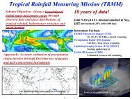
Tropical Rainfall Measuring Mission
Tropical Rainfall Measuring Mission
Tropical Rainfall Measuring Mission

Create successful ePaper yourself
Turn your PDF publications into a flip-book with our unique Google optimized e-Paper software.
TRMM<br />
<strong>Tropical</strong> <strong>Rainfall</strong> <strong>Measuring</strong> <strong>Mission</strong><br />
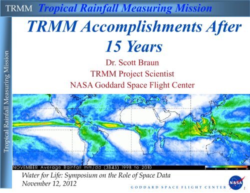
TRMM Accomplishments After<br />
<strong>Tropical</strong> <strong>Rainfall</strong> <strong>Measuring</strong> <strong>Mission</strong><br />
15 Years<br />
Dr. Scott Braun<br />
TRMM Project Scientist<br />
NASA Goddard Space Flight Center<br />
Water for Life: Symposium on the Role of Space Data<br />
November 12, 2012<br />
G O D D A R D S P A C E F L I G H T C E N T E R 1
TRMM<br />
TRMM Payload<br />
<strong>Tropical</strong> <strong>Rainfall</strong> <strong>Measuring</strong> <strong>Mission</strong><br />
Joint NASA/JAXA mission launched in Nov. 1997<br />
Instrument Payload:<br />
• TRMM Microwave Imager (TMI)— 10, 19, 37, 86 GHz, conical<br />
scanning<br />
• Precipitation Radar (PR) [Japan]— 14 GHz, cross-track scanning<br />
• Lightning Imaging Sensor (LIS)— Staring optical array [MSFC]<br />
• Visible IR Scanner (VIRS)— 5-channel, cross-track scanning<br />
• Clouds and Earth’s Radiant Energy System (CERES)<br />
Hurricane Sandy<br />
on Oct. 28, two<br />
days prior to<br />
landfall<br />
Hurricane Rina (October 26, 2011)<br />
G O D D A R D S P A C E F L I G H T C E N T E R 2
TRMM<br />
Focus Areas<br />
TRMM Science<br />
<strong>Tropical</strong> <strong>Rainfall</strong> <strong>Measuring</strong> <strong>Mission</strong><br />
Accomplishments<br />
Key focus areas:<br />
•Precipitation climatology: Global rainfall, diurnal cycle, latent<br />
heating<br />
•Convective systems research: The University of Utah<br />
Precipitation Feature Database<br />
•Floods: Science and applications<br />
•<strong>Tropical</strong> cyclones: Science and applications<br />
G O D D A R D S P A C E F L I G H T C E N T E R 3
TRMM<br />
TRMM <strong>Rainfall</strong>: Climatology<br />
<strong>Tropical</strong> <strong>Rainfall</strong> <strong>Measuring</strong> <strong>Mission</strong><br />
From<br />
Adler et al.<br />
(2009)<br />
•Benchmark 15 year climatology<br />
•Unique monitoring of<br />
interannual rainfall variations<br />
related to ENSO<br />
•TRMM estimates have become<br />
the standard for improving longterm<br />
climatologies and for<br />
comparison to global climate<br />
models<br />
From Dai (2006)<br />
G O D D A R D S P A C E F L I G H T C E N T E R 4
TRMM<br />
TRMM <strong>Rainfall</strong>: Diurnal Cycle<br />
<strong>Tropical</strong> <strong>Rainfall</strong> <strong>Measuring</strong> <strong>Mission</strong><br />
•Low inclination (35°),<br />
precessing orbit allows sampling<br />
of all local hours over several<br />
weeks<br />
•Quantification of diurnal cycle<br />
of precipitation tropics wide<br />
•Has also allowed focus on<br />
regional and local scales<br />
•Comparison with global climate<br />
models<br />
From Nesbitt and Zipser (2003)<br />
From Dai (2006)<br />
G O D D A R D S P A C E F L I G H T C E N T E R 5
TRMM<br />
TRMM <strong>Rainfall</strong>: Latent Heating Profiles<br />
<strong>Tropical</strong> <strong>Rainfall</strong> <strong>Measuring</strong> <strong>Mission</strong><br />
•Comprehensive estimates of how rainfall<br />
is directly related to latent heat release<br />
(LHR)<br />
•Quantification of LHR related to ENSO,<br />
MJO<br />
•Comparisons to global models<br />
MJO Phase<br />
Phase 1<br />
Phase 2<br />
Phase 3<br />
Phase 4<br />
Phase 5<br />
Phase 6<br />
Phase 7<br />
Phase 8<br />
Courtesy of W.‐K. Tao<br />
From Jiang et al. (2011)<br />
G O D D A R D S P A C E F L I G H T C E N T E R 6
TRMM<br />
The TRMM Precipitation Feature Database<br />
<strong>Tropical</strong> <strong>Rainfall</strong> <strong>Measuring</strong> <strong>Mission</strong><br />
University of Utah: E. Zipser, C. Liu, S. Nesbitt, D. Cecil, H.<br />
Jiang<br />
•TRMM PFD has yielded new insights into<br />
•diurnal cycle of convective systems<br />
•global distribution of convective extremes<br />
•properties of electrified storms<br />
•seasonal are regional distributions of warm rain<br />
•tropical cyclone rainfall properties<br />
Example Precip<br />
Features<br />
G O D D A R D S P A C E F L I G H T C E N T E R 7
TRMM<br />
The TRMM Precipitation Feature Database<br />
<strong>Tropical</strong> <strong>Rainfall</strong> <strong>Measuring</strong> <strong>Mission</strong><br />
•The value of the<br />
TRMM dataset for<br />
climate research<br />
increases with every<br />
year of additional<br />
data<br />
•With 14+ yrs of data,<br />
analyses of regional<br />
seasonal variability<br />
are now becoming<br />
possible<br />
Seasonal variability of precipitation features<br />
in the S.E. United States<br />
Feature size<br />
Month<br />
Feature 30-dBZ echo height<br />
Feature echo top<br />
Feature min. 85-GHz PCT<br />
Seasonal variation of radar (PR) precipitation feature (RPF) characteristics in the<br />
Southeastern U. S. including (a) precipitation feature size, (b) echo top, (c) 30‐dBZ echo<br />
height, and (d) minimum 85‐GHz polarization corrected temperature (PCT).<br />
Courtesy of Chuntao Liu and Ed Zipser.<br />
G O D D A R D S P A C E F L I G H T C E N T E R 8
TRMM<br />
Flood Events: Science<br />
TRMM 3B42 Avg. Rainrate<br />
Understanding Extreme Events Such as the 2010<br />
Pakistan Floods (From Houze et al. 2011)<br />
<strong>Tropical</strong> <strong>Rainfall</strong> <strong>Measuring</strong> <strong>Mission</strong><br />
700 hPa Height anomalies and winds<br />
TPW anomalies and 500 hPa winds<br />
Combining TRMM rainfall and vertical structure<br />
information with environmental information from global<br />
meteorological analyses allows better characterization of<br />
environmental regimes and the role of topography in<br />
extreme orographic events<br />
G O D D A R D S P A C E F L I G H T C E N T E R 9
TRMM<br />
TRMM Multi-Satellite Precipitation Analysis<br />
<strong>Tropical</strong> <strong>Rainfall</strong> <strong>Measuring</strong> <strong>Mission</strong><br />
3-hr window with passive<br />
microwave (gaps filled<br />
with Geo-IR) calibrated<br />
by TRMM<br />
(0.25°<br />
grid)<br />
Research product uses<br />
TRMM radar<br />
information and monthly<br />
gauges--real-time product<br />
avail. ~6 hrs. after obs.<br />
time<br />
9 years+ (‘98-’07)of 3-hr analysis available--produced at TRMM data system.<br />
Available from Goddard DISC (most downloaded TRMM product)<br />
G O D D A R D S P A C E F L I G H T C E N T E R 10
<strong>Tropical</strong> <strong>Rainfall</strong> <strong>Measuring</strong> <strong>Mission</strong><br />
TRMM<br />
Flood Events: Applications<br />
Multi-satellite rainfall estimates converted into<br />
probabilities of flood and landslide occurrence<br />
3-day heavy rains over 250 mm<br />
over Dominican Republic related to<br />
Hurricane Noel produces flooding<br />
(deduced by hydrologic model<br />
running globally in real-time) and<br />
landslides (estimated from real-time<br />
landslide potential algorithm)<br />
<strong>Rainfall</strong> information is from TRMM Multi-satellite Precipitation Analysis (TMPA)<br />
G O D D A R D S P A C E F L I G H T C E N T E R 11
TRMM<br />
TRMM data used by NOAA and DoD (and<br />
int’l agencies) for tropical cyclone detection,<br />
location and intensity estimation<br />
<strong>Tropical</strong> Cyclones: Applications<br />
Hurricane Katrina<br />
<strong>Tropical</strong> <strong>Rainfall</strong> <strong>Measuring</strong> <strong>Mission</strong><br />
~600 TRMM tropical cyclone “fixes” per year<br />
TRMM orbit always in tropics, sampling best<br />
in 10-35º latitude storm band<br />
High horizontal resolution<br />
Precessing orbit provides off-time observations<br />
relative to sun-synchronous satellites<br />
Hurricane Katrina-2005<br />
from TRMM web site<br />
TRMM image<br />
from NRL<br />
<strong>Tropical</strong> Cyclone<br />
web site<br />
TRMM radar (PR) crosssections<br />
of hurricanes<br />
available in real-time for<br />
operational analysis from<br />
TRMM web site<br />
G O D D A R D S P A C E F L I G H T C E N T E R 12
TRMM<br />
<strong>Tropical</strong> Cyclone Science<br />
<strong>Tropical</strong> <strong>Rainfall</strong> <strong>Measuring</strong> <strong>Mission</strong><br />
•<strong>Rainfall</strong> climatologies in<br />
hurricanes<br />
•Radial distribution<br />
•Shear and motion induced<br />
asymmetries<br />
•Eyewall and rainband<br />
vertical structure and<br />
lightning<br />
•Contributions to global<br />
precipitation<br />
•Precipitation feature<br />
database characteristics<br />
•Data assimilation<br />
•Evaluation of storm structures in<br />
mesoscale models<br />
Shear<br />
direction<br />
Normalized <strong>Rainfall</strong> anomaly<br />
From Chen et al. (2006)<br />
•Case studies<br />
•Improved SST estimates in storm<br />
wakes<br />
Courtesy of H. Jiang<br />
G O D D A R D S P A C E F L I G H T C E N T E R 13
TRMM<br />
Summary<br />
<strong>Tropical</strong> <strong>Rainfall</strong> <strong>Measuring</strong> <strong>Mission</strong><br />
• Space standard for measuring<br />
precipitation<br />
• Improved climatology of tropical<br />
rainfall and variations<br />
• Vertical hydrometeor/heating<br />
structure and diurnal signal<br />
• Improved climate and weather<br />
modeling<br />
• Impact of humans on<br />
precipitation<br />
• Hurricane/typhoon<br />
structure/evolution<br />
• Multi-satellite (~3-hr) rainfall<br />
analyses using TRMM+other<br />
satellites<br />
• Flood and agricultural<br />
applications<br />
• Operational use of data by<br />
Estimated Publications by year<br />
>3000 scientific journal<br />
articles published using<br />
TRMM data<br />
G O D D A R D S P A C E F L I G H T C E N T E R 14
TRMM<br />
Current Status<br />
Spacecraft and instrument status:<br />
• All spacecraft systems in excellent shape for continuation<br />
<strong>Tropical</strong> <strong>Rainfall</strong> <strong>Measuring</strong> <strong>Mission</strong><br />
• The Precipitation Radar, Microwave, Visible and IR<br />
Scanner, and Lightning Imaging Sensor (LIS) are all<br />
working well<br />
• Fuel required for<br />
altitude maintenance is<br />
expected to last until<br />
~January 2014<br />
G O D D A R D S P A C E F L I G H T C E N T E R 15


![4.12.2a_Tibet_Wu Guoxiong Tibet-CEOP.ppt[]](https://img.yumpu.com/35802437/1/190x135/4122a-tibet-wu-guoxiong-tibet-ceopppt.jpg?quality=85)