Tropical Rainfall Measuring Mission (TRMM)
Tropical Rainfall Measuring Mission (TRMM)
Tropical Rainfall Measuring Mission (TRMM)
- No tags were found...

Create successful ePaper yourself
Turn your PDF publications into a flip-book with our unique Google optimized e-Paper software.
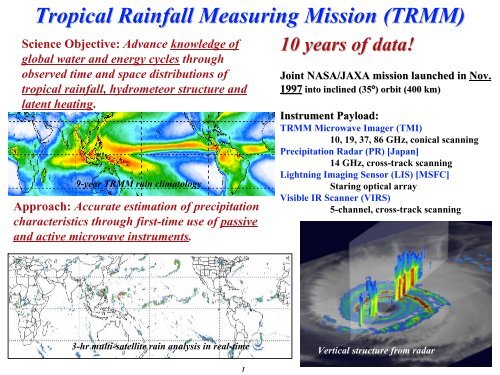
<strong>Tropical</strong> <strong>Rainfall</strong> <strong>Measuring</strong> <strong>Mission</strong> (<strong>TRMM</strong>)<br />
Science Objective: Advance knowledge of<br />
global water and energy cycles through<br />
observed time and space distributions of<br />
tropical rainfall, hydrometeor structure and<br />
latent heating.<br />
9-year <strong>TRMM</strong> rain climatology<br />
Approach: Accurate estimation of precipitation<br />
characteristics through first-time use of passive<br />
and active microwave instruments.<br />
10 years of data!<br />
Joint NASA/JAXA mission launched in Nov.<br />
1997 into inclined (35º) ) orbit (400 km)<br />
Instrument Payload:<br />
<strong>TRMM</strong> Microwave Imager (TMI)<br />
10, 19, 37, 86 GHz, conical scanning<br />
Precipitation Radar (PR) [Japan]<br />
14 GHz, cross-track scanning<br />
Lightning Imaging Sensor (LIS) [MSFC]<br />
Staring optical array<br />
Visible IR Scanner (VIRS)<br />
5-channel, cross-track scanning<br />
3-hr multi-satellite rain analysis in real-time<br />
Vertical structure from radar<br />
1
<strong>TRMM</strong> <strong>Mission</strong> Overview<br />
• <strong>TRMM</strong> launched in Nov. 1997 from Japan, orbit boosted from 350 to 402 km<br />
in Aug. 2001; 6+ years at 402 km, 3+ years at 350 km<br />
• <strong>TRMM</strong> started as an experimental mission, but has become the primary<br />
satellite in a global set of satellites to observe and study precipitation<br />
characteristics and variations<br />
• <strong>TRMM</strong> satellite data products (both research and real-time) produced by<br />
TSDIS [includes multi-instrument and multi-satellite products-from beginning<br />
of mission].<br />
• Spacecraft status: all spacecraft systems in excellent shape for continuation;<br />
one of two solar arrays is parked in horizontal position to avoid SADA failure.<br />
• Instrument status: Precipitation Radar (PR)--no moving parts, electrically<br />
scanning--no component limiting life; <strong>TRMM</strong> Microwave Imager (TMI)--has<br />
DoD instrument heritage with 10+ yr median lifetime; Visible and IR Scanner<br />
(VIRS)--very minor response degradation; Lightning Imaging Sensor (LIS)--<br />
no moving parts, no component limiting life<br />
2
<strong>TRMM</strong> Lifetime Prediction<br />
PVT Actual Propellant Remaining No August 2001 Boost March 2007 PlusEarly March 2007 MeanNom<br />
600<br />
Propellant Remaining (Kg)<br />
500<br />
400<br />
300<br />
200<br />
Initial fuel: 800+ kg<br />
Orbit raised from<br />
350 km. to 402 km.<br />
Station-keeping fuel sufficient to reach 2012-2013<br />
based on current solar flux forecasts<br />
<strong>TRMM</strong> fuel currently at 119 kg<br />
100<br />
No Boost<br />
Early solar cycle phase, high solar flux<br />
Nominal<br />
0<br />
Jan-01 Jan-02 Jan-03 Jan-04 Jan-05 Jan-06 Jan-07 Jan-08 Jan-09 Jan-10 Jan-11 Jan-12 Jan-13 Jan-<br />
Date (Mon-YY)<br />
3
Major Science Results<br />
Nearly 850 journal articles using <strong>TRMM</strong> data<br />
• Space standard for measuring precipitation<br />
• Improved climatology of tropical rainfall and variations<br />
• Vertical hydrometeor/heating structure and diurnal signal<br />
• Improved climate and weather modeling<br />
• Impact of humans on precipitation<br />
• Hurricane/typhoon structure/evolution<br />
• Multi-satellite (~3-hr) rainfall analyses using <strong>TRMM</strong>+other satellites<br />
• Flood and agricultural applications<br />
• Operational use of data by weather<br />
agencies.<br />
Number of <strong>TRMM</strong> papers<br />
Cumulative<br />
Yearly total<br />
4
<strong>TRMM</strong> Senior<br />
<strong>Tropical</strong> <strong>Rainfall</strong> <strong>Measuring</strong> <strong>Mission</strong><br />
<strong>TRMM</strong><br />
Senior Review Proposal<br />
2007<br />
Review<br />
• <strong>Mission</strong> reviewed every 2<br />
years<br />
• <strong>TRMM</strong> Viewed as central<br />
to NASA Strategic Plan<br />
and Earth Science<br />
Objectives<br />
• Ranked as having very<br />
high utility for operational<br />
agencies<br />
5
<strong>TRMM</strong> Basic <strong>Mission</strong> Extension:<br />
Data Products<br />
• Successful extension means continuation of <strong>TRMM</strong> Standard and real-time<br />
level 1, 2, 3 products (currently Version 6)<br />
• As part of overall Precipitation Measurement <strong>Mission</strong> (PMM) program<br />
improved Version 7 products will start in FY08-09. Version 7 is next step<br />
toward GPM products [TSDIS transitioning into Precipitation Processing<br />
System (PPS) for PMM (<strong>TRMM</strong>/GPM)].<br />
• Multi-instrument and multi-satellite products have been produced from day-1<br />
of <strong>TRMM</strong>. Current multi-satellite processing in TSDIS involves information<br />
from from eight microwave-instrumented satellites, plus geosynchronous IR<br />
information, plus raingauge information. Experience now is risk reduction for<br />
GPM.<br />
• Real-time <strong>TRMM</strong> single instrument and multi-satellite products extensively<br />
used by NOAA, DoD, Japan, Europe and international agencies<br />
6
Science with an Extended <strong>TRMM</strong> <strong>Mission</strong><br />
Overall Science Objective: Determine the time and space varying characteristics of<br />
tropical rainfall, hydrometeor structure, and associated latent heating and how these<br />
characteristics are related to variations in the global water and energy cycles<br />
Extended <strong>TRMM</strong> <strong>Mission</strong> will provide:<br />
• An improved climatology of precipitation characteristics, especially extremes<br />
• Improved diagnosis and closure of global (and regional) water cycles<br />
• Diagnosis and testing of inter-decadal and trend-related processes in the water cycle<br />
• Assessment of impact of humans (e.g., cities, deforestation, and aerosols) on rainfall<br />
characteristics and processes<br />
• Robust determination of convective system, tropical cyclone and lightning characteristics<br />
• Advances in hydrological applications over land on basin and continental scales<br />
• Improved modeling of global water/energy cycles for weather/climate predictions<br />
• Improved monitoring and forecasting of tropical cyclones, floods and other hazardous<br />
weather<br />
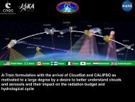
Extension of <strong>TRMM</strong> will take advantage of unique opportunity to obtain<br />
combined active and passive observations of clouds, aerosols, and<br />
precipitation with “A-Train”--Cloudsat, CALIPSO, Aqua--and <strong>TRMM</strong><br />
7
Science With Multiple Satellites: Does the<br />
Saharan Air Layer Have a Negative Influence<br />
on Hurricanes<br />
Some storms are surrounded by Saharan air and yet<br />
intensify to Category 4 or 5 intensity.<br />
Image: Hurricane Fabian (2003) surrounded by dry,<br />
dusty air. Data from <strong>TRMM</strong> 3B42, MODIS, and AIRS.<br />
Dust 24-h Accumulated Rain Relative Humidity 24-h Accumulated Rain<br />
8
Overview of Enhanced <strong>Mission</strong><br />
<strong>TRMM</strong> enhanced mission is very modest addition to basic mission continuation<br />
involving additional product generation and implementation of four products<br />
• Precipitation Feature (PF) database--involves adaptation as standard<br />
product of highly-used team member algorithm/product for wider<br />
distribution--allows for identification of characteristics of precipitation<br />
features (areas, etc.) rather than pixel information<br />
• Wide-swath primary precipitation product--improved multi-instrument<br />
product covering full swath and providing a <strong>TRMM</strong>-best instantaneous<br />
surface rain estimate<br />
• A-Train Subset of <strong>TRMM</strong> data--subsets of <strong>TRMM</strong> data matched with<br />
cross-overs with A-Train within various time offsets<br />
• <strong>Tropical</strong> cyclone accumulation rain maps using <strong>TRMM</strong> multi-satellite<br />
product and cyclone track information<br />
9
<strong>TRMM</strong> Data Used for Hurricane/Typhoon Monitoring<br />
<strong>TRMM</strong> TMI data used by NOAA and DoD (and int’l<br />
agencies) for tropical cyclone detection, location<br />
and intensity estimation--600 <strong>TRMM</strong>-based tropical<br />
cyclone “fixes” in 2004<br />
<strong>TRMM</strong> orbit advantageous for tropical cyclone<br />
monitoring--it is always in tropics, sampling best in<br />
10-35º latitude storm band. TMI resolution twice as<br />
good as operational sensors, about same as AMSR.<br />
Precessing orbit provides off-time observations<br />
relative to sun-synchronous microwave<br />
observations.<br />
Hurricane Katrina<br />
<strong>TRMM</strong> image from<br />
NRL <strong>Tropical</strong><br />
Cyclone web site<br />
from <strong>TRMM</strong> web site<br />
<strong>TRMM</strong> radar (PR) crosssections<br />
of hurricanes<br />
available in real-time for<br />
operational analysis from<br />
<strong>TRMM</strong> web site<br />
10
<strong>TRMM</strong> Detects Heavy <strong>Rainfall</strong> in Dominican<br />
Republic from <strong>Tropical</strong> Storm Noel<br />
• <strong>TRMM</strong> Multi-satellite<br />
precipitation analysis measures<br />
>400 mm of rain over D. R.<br />
and Haiti from Noel<br />
• 81 deaths, several hundred<br />
thousand displaced<br />
“Your images have been<br />
incredible--they are stunning and<br />
extremely useful. It was even<br />
presented to the minister of<br />
environment and head of disasters<br />
in the DR. Deeply appreciated.<br />
Please know we are crediting you<br />
everywhere.” – Daniel Irwin, MSFC,<br />
SERVIR Project Manager<br />
11<br />
Images by Hal Pierce, NASA/GSFC
http://trmm.gsfc.nasa.gov<br />
12
<strong>TRMM</strong> Tracks <strong>Tropical</strong> Cyclone <strong>Rainfall</strong><br />
• <strong>Rainfall</strong> accumulation maps<br />
available on <strong>TRMM</strong> web page:<br />
http://trmm.gsfc.nasa.gov<br />
• ATL and EPAC available June-<br />
Oct 1998-2006<br />
• WPAC available June-Oct 1998-<br />
2005<br />
• N. Indian Ocean available June-<br />
Oct 1998-2004<br />
• Combined with other satellites, the<br />
<strong>TRMM</strong> multi-satellite precipitation<br />
analysis (3B42) helps map rainfall<br />
evolution in hurricanes.<br />
Hurricane Isabel<br />
accumulated<br />
rainfall<br />
13
http://trmm.gsfc.nasa.gov<br />
14
3 rd International <strong>TRMM</strong> Science<br />
Conference<br />
February 4-8, 2007<br />
Las Vegas, NV<br />
202 Abstracts submitted<br />
15

![4.12.2a_Tibet_Wu Guoxiong Tibet-CEOP.ppt[]](https://img.yumpu.com/35802437/1/190x135/4122a-tibet-wu-guoxiong-tibet-ceopppt.jpg?quality=85)