Edition 08 of 2008. - Indian Naval Hydrographic Department
Edition 08 of 2008. - Indian Naval Hydrographic Department
Edition 08 of 2008. - Indian Naval Hydrographic Department
Create successful ePaper yourself
Turn your PDF publications into a flip-book with our unique Google optimized e-Paper software.
13<br />
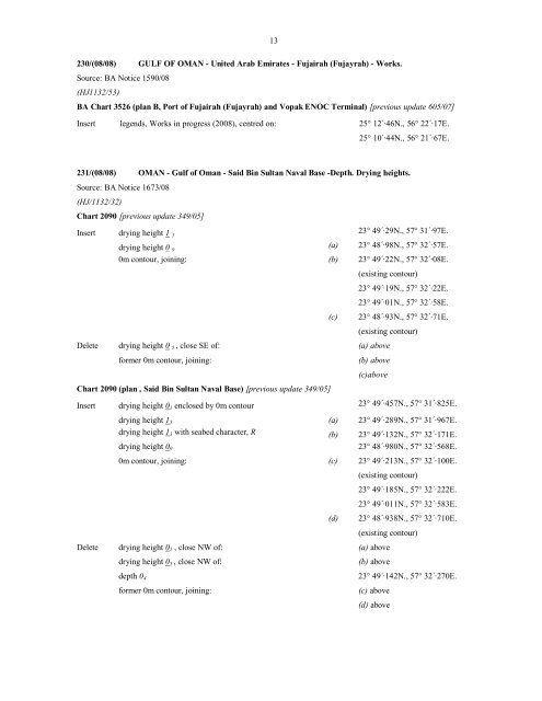
230/(<strong>08</strong>/<strong>08</strong>) GULF OF OMAN - United Arab Emirates - Fujairah (Fujayrah) - Works.<br />
Source: BA Notice 1590/<strong>08</strong><br />
(HJ1132/53)<br />
BA Chart 3526 (plan B, Port <strong>of</strong> Fujairah (Fujayrah) and Vopak ENOC Terminal) [previous update 605/07]<br />
Insert legends, Works in progress (20<strong>08</strong>), centred on: 25° 12´·46N., 56° 22´·17E.<br />
25° 10´·44N., 56° 21´·67E.<br />
231/(<strong>08</strong>/<strong>08</strong>) OMAN - Gulf <strong>of</strong> Oman - Said Bin Sultan <strong>Naval</strong> Base -Depth. Drying heights.<br />
Source: BA Notice 1673/<strong>08</strong><br />
(HJ/1132/32)<br />
Chart 2090 [previous update 349/05]<br />
Insert drying height 1 5<br />
23° 49´·29N., 57° 31´·97E.<br />
drying height 0 9<br />
(a) 23° 48´·98N., 57° 32´·57E.<br />
0m contour, joining: (b) 23° 49´·22N., 57° 32´·<strong>08</strong>E.<br />
(existing contour)<br />
23° 49´·19N., 57° 32´·22E.<br />
23° 49´·01N., 57° 32´·58E.<br />
(c)<br />
23° 48´·93N., 57° 32´·71E.<br />
(existing contour)<br />
Delete drying height 0 5 , close SE <strong>of</strong>: (a) above<br />
former 0m contour, joining: (b) above<br />
Chart 2090 (plan , Said Bin Sultan <strong>Naval</strong> Base) [previous update 349/05]<br />
(c)above<br />
Insert drying height 0 1 enclosed by 0m contour 23° 49´·457N., 57° 31´·825E.<br />
drying height 1 5 (a) 23° 49´·289N., 57° 31´·967E.<br />
drying height 1 3 with seabed character, R (b) 23° 49´·132N., 57° 32´·171E.<br />
drying height 0 9 23° 48´·980N., 57° 32´·568E.<br />
0m contour, joining: (c) 23° 49´·213N., 57° 32´·100E.<br />
(existing contour)<br />
23° 49´·185N., 57° 32´·222E.<br />
23° 49´·011N., 57° 32´·583E.<br />
(d)<br />
23° 48´·938N., 57° 32´·710E.<br />
(existing contour)<br />
Delete drying height 0 1 , close NW <strong>of</strong>: (a) above<br />
drying height 0 5 , close NW <strong>of</strong>: (b) above<br />
depth 0 4 23° 49´·142N., 57° 32´·270E.<br />
former 0m contour, joining: (c) above<br />
(d) above


