Edition 08 of 2008. - Indian Naval Hydrographic Department
Edition 08 of 2008. - Indian Naval Hydrographic Department
Edition 08 of 2008. - Indian Naval Hydrographic Department
You also want an ePaper? Increase the reach of your titles
YUMPU automatically turns print PDFs into web optimized ePapers that Google loves.
25<br />
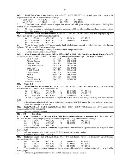
147. India West Coast – Arabian Sea. Charts 21 22 253 292 293 INT 705. Seismic survey is in progress by<br />
Sagar Sandhani till 20 Apr 20<strong>08</strong> in area bounded by:<br />
(a) 19-51.0N 070-45.0E (b) 19-51.0N 071-32.0E<br />
(c) 19-17.0N 071-32.0E (d) 19-17.0N 070-45.0E<br />
2. Vessel towing two seismic cables <strong>of</strong> length 5000 meters each with green and yellow buoys with flashing light<br />
to mark the tail end <strong>of</strong> the cables.<br />
3. All vessels operating in vicinity are to maintain a clearance <strong>of</strong> 06 nm all around the vessel and exercise caution.<br />
4. Cancel this message on 21 Apr 20<strong>08</strong>.<br />
148. India West Coast- Lakshadweep Sea. Charts 22 258 259 260 INT 705. Seismic survey is in progress by MV<br />
Munin explorer till 15 Apr 20<strong>08</strong> in area bounded by:<br />
(a) 11-20.0N 075-41.0E (b) 11-20. 0N 073-43.0E<br />
(c) <strong>08</strong>-43.0N 073-43.0E (d) <strong>08</strong>-43.0N 076-13.0E<br />
(e) 09-37.0N 076-13.0E<br />
2. Vessel towing a single 12000 metres digital fluid filled streamer marked by yellow tail buoy with flashing<br />
light and GPS tracker with 02 metre mast height.<br />
3. All vessels operating in vicinity to exercise caution and give wide berth.<br />
4. Cancel this message on 16 Apr 20<strong>08</strong>.<br />
149. Cancel Navarea Eight message 105 114 127 and 143 <strong>of</strong> 20<strong>08</strong>. India East Coast– Bay <strong>of</strong> Bengal. Charts 31<br />
32 33 301 351 352 353 354 355 356 357 3009 INT 706. Present position <strong>of</strong> Oil Rigs / Drill Ships as follows:<br />
Essar Wildcat 16-41.70N <strong>08</strong>2-31.70E<br />
Atwood Beacon 16-41.00N <strong>08</strong>2-26.20E<br />
Discoverer 534 16-30.10N <strong>08</strong>2-31.70E<br />
Deep Water Frontier 16-29.60N <strong>08</strong>2-32.20E<br />
Sagar Vijay 17-29.20N <strong>08</strong>3-29.50E<br />
C Kirk Rhein Jr 15-53.20N <strong>08</strong>1-33.40E<br />
Deep Driller I 16-42.90N <strong>08</strong>2-28.80E<br />
Aban II 21-04.90N <strong>08</strong>8-43.00E<br />
Actinia 17-39.00N <strong>08</strong>3-18.00E<br />
Deep Driller – 4 20-47.50N <strong>08</strong>7-58.50E<br />
2. Wide berth requested.<br />
150. Cancelled.<br />
151. India West Coast – Arabian Sea. Charts 21 22 253 254 255 292 INT 705. Seismic survey is in progress by<br />
Pacific Sword till 31 May 20<strong>08</strong> in area bounded by:<br />
(a) 20-30.33N 071-46.12E (b) 20-45.92N 071-46.12E<br />
(c) 20-52.82N 071-53.12E (d) 20-53.12N 072-10.52E<br />
(e) 20-46.54N 072-10.52E (f) 20-39.49N 072-03.06E<br />
2. Vessel towing two streamer cables <strong>of</strong> length 5100 metres attached with orange tail buoy with white flashing<br />
light.<br />
3. All vessels operating in vicinity are to maintain a clearance <strong>of</strong> 05NM all around the vessel and exercise caution.<br />
4. Cancel this message on 01 Jun 20<strong>08</strong>.<br />
152. India West Coast – Gulf <strong>of</strong> Kachchh. Charts 21 251 252 271 292 INT 705. Fishing boat MFV Shajan-2 Sunk<br />
in position 22-25.17N., 068-06.17E.<br />
2. Mariners to exercise caution.<br />
153 to 154. Cancelled.<br />
155. Cancel Navarea Eight Message 076 <strong>of</strong> 20<strong>08</strong>. India Andaman islands – Andaman Sea. Charts 33 41 473<br />
INT 706. Seismic survey is in progress by vessel Geco Topaz till 31 May 20<strong>08</strong> in area bounded by:<br />
(a) 13-34.0N 094-27.0E (b) 13-45.0N 095-03.0E<br />
(c) 12-54.0N 095-39.0E (d) 12-45.0N 095-35.0E<br />
(e) 12-45.0N 094-57.0e<br />
2. Vessel towing <strong>08</strong> in number 7500 metres long streamer cable attached to a yellow colour tail buoy with white<br />
flashing light.<br />
3. All vessels operating in vicinity to give 06NM clearance and exercise caution.<br />
4. Cancel this message on 01 Jun 20<strong>08</strong>.<br />
156. India East Coast – Bay <strong>of</strong> Bengal. Charts 33 357 INT 706. Seismic survey is in progress by vessel Osaprey<br />
explorer in area bounded by:<br />
(a) 14-30.0N <strong>08</strong>1-15.0E (b) 14-30.0N <strong>08</strong>1-56.0E<br />
(c) 12-45.5N <strong>08</strong>3-36.8E (d) 12-00.0N <strong>08</strong>3-30.0E<br />
(e) 11-30.0N <strong>08</strong>3-15.0E (f) 11-00.0N <strong>08</strong>1-15.0E<br />
2. Vessel towing 01 in number 8000 metres long streamer cable attached to a yellow colour tail buoy with white<br />
flashing light.<br />
3. .all vessels operating in vicinity to give 06NM clearence and exercise caution.


