Edition 08 of 2008. - Indian Naval Hydrographic Department
Edition 08 of 2008. - Indian Naval Hydrographic Department
Edition 08 of 2008. - Indian Naval Hydrographic Department
Create successful ePaper yourself
Turn your PDF publications into a flip-book with our unique Google optimized e-Paper software.
17<br />
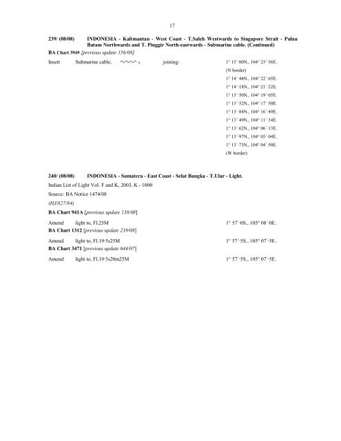
239/ (<strong>08</strong>/<strong>08</strong>) INDONESIA - Kalimantan - West Coast - T.Saleh Westwards to Singapore Strait - Pulau<br />
Batam Northwards and T. Pinggir North-eastwards - Submarine cable. (Continued)<br />
BA Chart 3949 [previous update 156/<strong>08</strong>]<br />
Insert Submarine cable, joining: 1° 15´·00N., 104° 23´·56E.<br />
(N border)<br />
1° 14´·44N., 104° 22´·65E.<br />
1° 14´·18N., 104° 21´·22E.<br />
1° 13´·50N., 104° 19´·05E.<br />
1° 13´·52N., 104° 17´·50E.<br />
1° 13´·84N., 104° 16´·49E.<br />
1° 13´·49N., 104° 11´·34E.<br />
1° 13´·62N., 104° 06´·13E.<br />
1° 13´·97N., 104° 05´·04E.<br />
1° 13´·73N., 104° 04´·50E.<br />
(W border)<br />
240/ (<strong>08</strong>/<strong>08</strong>) INDONESIA - Sumatera - East Coast - Selat Bangka - T.Ular - Light.<br />
<strong>Indian</strong> List <strong>of</strong> Light Vol. F and K, 2003, K - 1000<br />
Source: BA Notice 1474/<strong>08</strong><br />
(HJ/827/84)<br />
BA Chart 941A [previous update 138/<strong>08</strong>]<br />
Amend light to, Fl.25M 1° 57´·0S., 105° <strong>08</strong>´·0E.<br />
BA Chart 1312 [previous update 239/<strong>08</strong>]<br />
Amend light to, Fl.19·5s25M 1° 57´·5S., 105° 07´·5E.<br />
BA Chart 3471 [previous update 644/07]<br />
Amend light to, Fl.19·5s20m25M 1° 57´·5S., 105° 07´·5E.


