

Edition 08 of 2008. - Indian Naval Hydrographic Department
Edition 08 of 2008. - Indian Naval Hydrographic Department
Edition 08 of 2008. - Indian Naval Hydrographic Department

Create successful ePaper yourself
Turn your PDF publications into a flip-book with our unique Google optimized e-Paper software.
20<br />
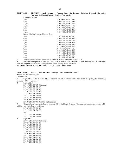
248(P)(<strong>08</strong>/<strong>08</strong>) ERITREA - Aseb (Assab) - Fatuma Deset Northwards, Rubetino Channel, Darmakia<br />
Northwards, Umm-al Sciora - Depths. (Continued)<br />
Rubetino Channel<br />
1 7 m 13° 01´·00N., 42° 50´·54E.<br />
8 8 m 13° 00´·58N., 42° 50´·73E.<br />
12 5 m 13° 00´·14N., 42° 50´·71E.<br />
12 1 m 13° 01´·09N., 42° 49´·95E.<br />
7 1 m 13° 01´·50N., 42° 50´·21E.<br />
2 7 m 13° 00´·95N., 42° 50´·40E.<br />
11 8 m 13° 00´·74N., 42° 50´·15E.<br />
Darma -kia Northwards - Umm-al Sciora<br />
7 9 m 12° 59´·38N., 42° 48´·38E.<br />
0 6 m 13° 00´·41N., 42° 47´·49E.<br />
9 5 m 12° 59´·41N., 42° 49´·07E.<br />
3 2 m 13° 00´·97N., 42° 48´·50E.<br />
3 5 m 13° 00´·59N., 42° 48´·84E.<br />
4 4 m 12° 58´·99N., 42° 48´·66E.<br />
9 6 m 12° 59´·24N., 42° 49´·01E.<br />
3 9 m 12° 58´·80N., 42° 48´·41E.<br />
7 8 m 12° 59´·64N., 42° 48´·53E.<br />
3 7 m 13° 00´·45N., 42° 48´·85E.<br />
8 1 m 12° 59´·58N., 42° 48´·34E.<br />
2. These and other changes will be included in the next New <strong>Edition</strong> <strong>of</strong> Chart 1926.<br />
3. Mariners are requested to note that Chart 1926 is referred to WGS72 Datum. 0·01 minutes must be subtracted<br />
from the longitude values <strong>of</strong> the above positions before plotting onto Chart 1926.<br />
BA Charts affected -6 - 143 (INT 7005) - 157 (INT 7006) - 1925 - 1926<br />
249(P)(<strong>08</strong>/<strong>08</strong>) UNITED ARAB EMIRATES - QATAR - Submarine cables.<br />
Source: BA Notice 1446(P)/<strong>08</strong><br />
(HJ/1132/54)<br />
1. Segments 2.3 and 3 <strong>of</strong> the FLAG Telecom Falcon submarine cable have been laid joining the following<br />
positions (WGS84 Datum):<br />
2. Segment 2.3<br />
25° 04´·3N., 55° 07´·5E.(shore)<br />
25° 05´·6N., 55° 05´·3E.<br />
25° 05´·9N., 55° 04´·6E.<br />
25° 10´·2N., 55° 02´·0E.<br />
25° 23´·6N., 54° 59´·3E.<br />
25° 27´·2N., 55° 00´·3E.<br />
25° 34´·7N., 55° 14´·2E.<br />
25° 39´·6N., 55° 18´·2E.<br />
25° 59´·5N., 55° 40´·0E.(50m depth contour)<br />
3. *Repairs have been carried out to segment 2.3 <strong>of</strong> the FLAG Telecom Falcon submarine cable, with new cable<br />
laid between the following positions:<br />
25° 30´·5N., 55° 06´·4E.<br />
25° 25´·9N., 54° 59´·7E.<br />
and<br />
25° 25´·1N., 54° 59´·6E.<br />
25° 17´·7N., 55° 00´·5E.<br />
4. Segment 3<br />
25° 04´·2N., 55° 07´·4E.(shore)<br />
25° 05´·4N., 55° 05´·2E.<br />
25° 05´·6N., 55° 04´·6E.<br />
25° 06´·4N., 55° 03´·6E.<br />
25° <strong>08</strong>´·5N., 55° 02´·6E.<br />
25° <strong>08</strong>´·8N., 55° 01´·2E.<br />
25° 10´·6N., 55° 00´·3E.<br />
25° 11´·5N., 54° 58´·8E.<br />
25° 12´·6N., 54° 55´·2E.<br />
25° 16´·5N., 54° 47´·2E.<br />
25° 17´·2N., 54° 40´·3E.


