

Edition 08 of 2008. - Indian Naval Hydrographic Department
Edition 08 of 2008. - Indian Naval Hydrographic Department
Edition 08 of 2008. - Indian Naval Hydrographic Department

You also want an ePaper? Increase the reach of your titles
YUMPU automatically turns print PDFs into web optimized ePapers that Google loves.
14<br />
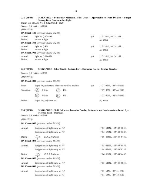
232/ (<strong>08</strong>/<strong>08</strong>) MALAYSIA - Peninsular Malaysia, West Coast - Approaches to Port Dickson - Sungei<br />
Sepang Besar Southwards - Light.<br />
<strong>Indian</strong> List <strong>of</strong> Light Vol F & K 2003, F- 1620<br />
Source: BA Notice 1657/<strong>08</strong><br />
(HJ/927/28)<br />
BA Chart 1140 [previous update 042/<strong>08</strong>]<br />
Amend light to, Q.62ft8M (a) 2° 35´·0N., 101° 42´·9E.<br />
Delete sectors at light (a) above<br />
BA Chart 1358 [previous update 042/<strong>08</strong>]<br />
Amend light to, Q.8M (a) 2° 35´·0N., 101° 42´·9E.<br />
Delete sectors at light (a) above<br />
BA Chart 3946 [previous update 042/<strong>08</strong>]<br />
Amend light to, Q.19m8M (a) 2° 35´·0N., 101° 42´·9E.<br />
Delete sectors at light (a) above<br />
233/ (<strong>08</strong>/<strong>08</strong>) SINGAPORE - Johor Strait - Eastern Part - Ordnance Reach - Depths. Wrecks.<br />
Source: BA Notice 1614/<strong>08</strong><br />
(HJ/927/16)<br />
BA Chart 4044 [previous update 196/<strong>08</strong>]<br />
Insert depth 14 3 and extend 15m contour N to enclose (a) 1° 27´·39N., 103° 46´·65E.<br />
Substitute Wk for Wk 1° 27´·36N., 103° 46´·90E.<br />
Wk for Wk 1° 27´·50N., 103° 47´·10E.<br />
Delete depth 16 5 , adjacent to: (a) above<br />
234/ (<strong>08</strong>/<strong>08</strong>) SINGAPORE - Sinki Fairway - Terumbu Pandan Eastwards and South-westwards and Ayer<br />
Merbau Basin - Buoyage.<br />
Source: BA Notice 1612/<strong>08</strong><br />
(HJ/927/16)<br />
BA Chart 4032 [previous update 213/<strong>08</strong>]<br />
Amend designation <strong>of</strong> light-buoy to, H4 1° 15´·611N., 103° 45´·885E.<br />
designation <strong>of</strong> light-buoy to, H5 1° 14´·636N., 103° 43´·828E.<br />
Delete Fl.R.2.5s Butun 1° 16´·066N., 103° 43´·648E.<br />
R<br />
BA Chart 4034 [previous update 164/<strong>08</strong>]<br />
Amend designation <strong>of</strong> light-buoy to, H4 1° 15´·611N., 103° 45´·885E.<br />
designation <strong>of</strong> light-buoy to, H5 1° 14´·636N., 103° 43´·828E.<br />
Delete Fl.R.2.5s Butun 1° 16´·066N., 103° 43´·648E.<br />
R<br />
BA Chart 4035 [previous update 163/<strong>08</strong>]<br />
Amend designation <strong>of</strong> light-buoy to, H4 1° 15´·611N., 103° 45´·885E.<br />
BA Chart 4040 [previous update 213/<strong>08</strong>]<br />
Amend designation <strong>of</strong> light-buoy to, H4 1° 15´·61N., 103° 45´·89E.<br />
designation <strong>of</strong> light-buoy to, H5 1° 14´·64N., 103° 43´·83E.


