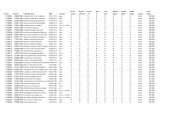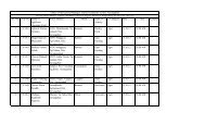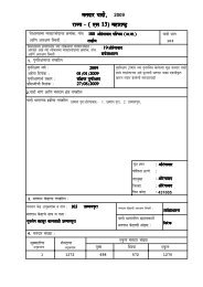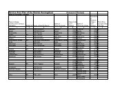
9. group no. transport & communication
9. group no. transport & communication
9. group no. transport & communication

You also want an ePaper? Increase the reach of your titles
YUMPU automatically turns print PDFs into web optimized ePapers that Google loves.
INDRODUCTION :-<br />
Aurangabad, the Capital of Marathwada Region of Maharashtra is famous<br />
for its rich cultural heritage. The famous Ajanta Caves, Ellora Caves, Daulatabad<br />
Fort, Bibi-ka-Makbara are world famous Tourism centre.<br />
Being located in centre of Maharashtra it is one of the rapidly developing<br />
city in the State. It is also hub for Automobile industries.<br />
The District spread in 10107 Sq. Km. with population of 28.9 lakhs as per 2001<br />
census and 1300 Village.<br />
TRANSPORTATION :-<br />
An efficient <strong>transport</strong> system in the lifeline of the eco<strong>no</strong>my. A dense and<br />
efficient network of connectivity is a pre requisite<br />
for overall eco<strong>no</strong>my<br />
development and growth of trade.<br />
Mainly there are three mode of <strong>transport</strong>ation.<br />
a) Roadway<br />
b) Railway<br />
c) Airway<br />
a) Roadway :- The State road network consists of<br />
1) National Highway<br />
2) State Highway<br />
3) Major District Roads
4) Other District Roads<br />
5) Village Roads.<br />
The road developments works in the state are carried out by<br />
i) Public Works Department<br />
ii)<br />
iii)<br />
iv)<br />
Zilla Parishad (Z.P.)<br />
Municipal Corporation / Councils/ Nagar Panchayats<br />
Cantonments Roads<br />
v) MSRDC, MIDC, CIDCO<br />
Brief Definition of above category of road is stated below :<br />
1) National Highway :- National Highway main highway running through<br />
the length and breadth of India, connecting major ports, foreign<br />
highway capital of large state and large industrial and tourist centers<br />
including roads required the strategic movements of the defense of<br />
India.<br />
2) State Highway :- State Highway are arterial road of a state connecting<br />
up with the national highway of adjacent states, district road quarters<br />
and important cities within the state and serving as the main arteries for<br />
traffic to and from district roads.<br />
3) Major District Road :- Major District road are important roads within a<br />
district serving areas of production and markets and connecting those<br />
with each other or within highways of a district. The MDR have lower<br />
2
speed & geometric design specification than National Highway / State<br />
Highway.<br />
4) Other District Road :- Other District road are roads serving rural areas of<br />
production and providing them with outlet to market centre, taluka<br />
head quarter, block development road quarter or other main road.<br />
5) Village Road :- Village road are roads connecting villages or <strong>group</strong> of<br />
village with each other to the nearest road of higher category.<br />
Road Developments work in Aurangabad District<br />
The Road Development plan for Aurangabad District taking into<br />
consideration the recommendation of the IRC, the other important objective<br />
of the Road Development Plan – 1981-2011 where<br />
1) Expansion of National Highway Network<br />
2) Construction of Express way on Major Traffic corridor<br />
3) Extension of state Highway to District Head Quarter, Industrial Center, Tourist<br />
Center<br />
4) MDR to connect villages with population 1000-1500<br />
Salient feature of Road Development Plan 2001-2010 :<br />
following are some important salient feature of Road Development plan<br />
2001-2021<br />
i) To construct National Highway such that , informs 100 km square<br />
network.<br />
3
ii)<br />
To construct Express Highway for fast moving vehicle and Four<br />
laning on road having maximum traffic density.<br />
iii)<br />
To connect District Highway road quarter by four lane, Taluka<br />
head quarter, Industrial centre, Tourist centre by Two lane State<br />
Highways.<br />
iv)<br />
To connect Village having population more than 1500 by MDR.<br />
v) To connect Village having population1000 to 1500 by ODR.<br />
vi)<br />
To connect remote Village by all weather road.<br />
4
CURRENT STATUS : -<br />
The existing road length in Aurangabad District & other District of<br />
Marathwada Category wise is given below :<br />
Table No. 1<br />
Sr.<br />
District<br />
National<br />
MSH &<br />
Length in KM<br />
MDR ODR VR Total<br />
No.<br />
Highway<br />
SH<br />
1 Aurangabad 134.2 1194.22 1733.3 1224.26 3795.26 8078.58<br />
2 Jalna 24.56 1247.40 1055.7 1370 2746.2 6443.9<br />
3 Parbhani 68.14 660.52 1064.58 740.45 2894.75 5428.44<br />
4 Hingoli 36.0 503.45 787.55 485.75 2022.42 3835.17<br />
5 Nanded 95.0 1256.46 2677.2 1445.5 5241.09 10715.19<br />
6 Beed 193.35 1212.05 1684.3 1438.05 4332.39 8860.14<br />
7 Osmanabad 202.92 864.42 1336.0 1168.2 255<strong>9.</strong>34 6130.88<br />
8 Latur 0 853 1547 1364 2281.2 6054.2<br />
Total 754.17 7791.50 11885.93 9236.25 2586<strong>9.</strong>65 55537.5<br />
Ratio of Total road length in km by total area in Sq. km 0.85<br />
5
Taluka wise Breakup of Existing Road Length in Aurangabad District is given in<br />
Table No. 2<br />
Sr. Name of<br />
Existing Length of Road in Km<br />
Total<br />
No. Taluka NH MSH SH MDR ODR VR Length<br />
1 Aurangabad 60.24 70.22 104.70 192.95 46.90 387.0 862.01<br />
2 Paithan 25.20 00 134.00 242.25 227.90 440.50 106<strong>9.</strong>85<br />
3 Phulambri 0.0 24.20 32.00 125.45 73.80 405.60 661.05<br />
4 Sillod 0.0 45.00 101.50 182.75 163.20 427.60 93<strong>9.</strong>45<br />
5 Soyegaon 0.0 10.00 88.50 77.55 42.60 19<strong>9.</strong>10 417.75<br />
6 Kannad 32.76 0 155.60 25<strong>9.</strong>45 145.10 650.50 1243.41<br />
7 Khultabad 16.00 0 6<strong>9.</strong>60 73.75 53.10 183.66 395.51<br />
8 Gangapur 00 0 18<strong>9.</strong>60 290.80 178.10 476.40 1135.00<br />
9 Vaijapur 00 0 16<strong>9.</strong>90 288.65 273.60 623.10 1354.55<br />
Total 134.20 14<strong>9.</strong>42 1044.80 1733.60 1224.50 3792.25 8078.28<br />
6
SWOT ANALYSIS :<br />
While preparing this documents the working <strong>group</strong> has adopted SWOT<br />
Analysis as a tool for visioning the future of the District Aurangabad.<br />
a) Strength :<br />
i) Engineer having vast experienced in construction of Roads and<br />
Bridges.<br />
ii)<br />
iii)<br />
iv)<br />
Technical guidance from Chief Engineer.<br />
Separate organization for Design / Survey of Bridge and Roads.<br />
Vigilance and Quality wings to asses quality of work.<br />
b) Weakness :<br />
i) Inadequate fund from Govt. for development of Road.<br />
ii)<br />
Lengthy process of Land Acquisition.<br />
c) Opportunities :<br />
i) Aurangabad is Centrally located on the map of the States.<br />
ii)<br />
iii)<br />
iv)<br />
Fastest Developing city in the state.<br />
Attractive tourist destination.<br />
Eight laning of Delhi-Mumbai Industrial corridor.<br />
d) Threat :<br />
i) Slow pace of development due to <strong>no</strong>n- availability of timely<br />
resources.<br />
7
VISION AND OBJECTIVES:<br />
Vision statement:<br />
“To create District as a world class facilities for development of<br />
Industries, Tourism, Major boost to Agro-based industries by developing<br />
Transportation facilities, connecting all villages by Black Topped roads,<br />
thus saving time and fuel in <strong>transport</strong>ation & thereby contributing to the<br />
Social, Eco<strong>no</strong>mical and overall Development of the District<br />
Aurangabad”<br />
Developmental Objectives:-<br />
1) Road way:<br />
i) Development of State Highway networks<br />
ii)<br />
Four laning of Sate Highway having maximum traffic density<br />
through PPP<br />
iii)<br />
iv)<br />
Development of MDR networks<br />
To complete construction of Ring road around Aurangabad city<br />
and finalized the Alignment of Outer Ring road along with Land<br />
acquisition<br />
v) Eight laning of Delhi-Mumbai Industrial corridor passing through<br />
Aurangabad.<br />
vi)<br />
To connect Taluka Head quarter with Two lane road<br />
8
vii)<br />
To connect Taluka Head quarter with District Head quarter with<br />
Two lane road<br />
viii)<br />
ix)<br />
To construct ROB at required level crossing<br />
Upgradation of road networks<br />
x) To improve Road Safety measures<br />
xi)<br />
xii)<br />
Strengthening of existing roads<br />
Connecting all village with Black Toppped roads<br />
2) Airways:<br />
i) To develop Aurangabad Airport with international facilities<br />
ii)<br />
iii)<br />
To construct permanent Helipad at Taluka level<br />
Daily flight connecting Aurangabad with major cities in the<br />
country<br />
3) Railways:<br />
i) To improve existing facilities of Railways line by providing Double<br />
lane between Mammad-aurangabad section<br />
ii)<br />
Electrification of Railway track<br />
iii) To develop Satellite Railway station at Mukundwadi with<br />
adequate facilities<br />
iv)<br />
International facilities at Aurangabad station<br />
4) Communication:<br />
i) Connecting all villages by Landline/Mobile services<br />
ii)<br />
Providing Broad Band facilities to all the villages in district.<br />
9
INDICATORS:<br />
The working <strong>group</strong> formed for the Transportation and Communication<br />
has laid down the Indicators on the basis of its and objective.<br />
Some Statistical indicators depicting the present scenario and future<br />
projection are presented in the table.<br />
Indicators for Development Objectives:<br />
TABLE NO :4<br />
Sr. <strong>no</strong>. Indicators Present Status Future Projection<br />
1. Total Road length per Sq.<br />
km. of area<br />
2 Blacked Topped Road<br />
Surface<br />
3 Four laning of State<br />
Highway<br />
4 Four laning of National<br />
Highway<br />
0.798 km 1.00 km<br />
58 % 100%<br />
66 km 218.00 km<br />
11 km 143.00 km<br />
10
ONGING SCHEMES:<br />
In order to develop the road networks and carrying out the works of<br />
improvement to bring the existing networks to the required standard and<br />
specification, GOM have raised fund from various resources like assistance from<br />
the NABARD, HUDCO, Private investment for BOT works etc. apart from Plan &<br />
Non-plan works allocation from Annual State budget.<br />
The Road development has been implemented by taking up works under<br />
various scheme such as MREGS, PMGSY, BOT, works through RIDF project, CRF,<br />
NABARD loan. All this construction activity had given boost to increase the<br />
employment to Skills and Unskilled works on a large scale.<br />
Details of some Important scheme Implemented:<br />
1.Works through Centre Road Fund (CRF)<br />
The details of works done under CRF are as given in the table<br />
TABLE NO. 5<br />
Sr. No of works Est. Cost Exp. upto No of works No of works<br />
<strong>no</strong>.<br />
Rs in lakhs 31/3/2010 completed in progress<br />
1 17 340<strong>9.</strong>81 1923.64 9 5<br />
2) Marathwada Development Programme:<br />
To fulfill the Backlog of Marathwada region, Govt. started the Marathwada<br />
vikad programme. Works of Roads and Bridges are taken under MVP in district.<br />
3) Works carried through Loan Assistance received from NABARD:-<br />
11
To connect the villages by all weather roads, one of scheme is by<br />
assistance of NABARD Bank. As per <strong>no</strong>rms of NABARD Bank, village road<br />
development programme is taken so that the Agricultural production from village<br />
can be taken to market throughout the year.<br />
Abstract of works done through NABARD ( scheme 3 to 8 and 9 to 15) are<br />
given in table below.<br />
TABLE NO. 6<br />
Sr. <strong>no</strong>. No. of NABARD Exp. No of No of Remarks<br />
works Grant Rs upto works works in<br />
Sanctioned in lakhs 3/2010 completed progress<br />
1 170 4560.9 4433.9 170 - 3 to 8<br />
scheme<br />
2 59 2571.39 218<strong>9.</strong>17 36 21 9 to 15<br />
scheme<br />
4)Village Connectivity:-<br />
As per Govt. <strong>no</strong>rms all village having population more than 2000 as per<br />
1991 census , these villages are to connected with blacked topped roads.<br />
The works of village connectivity is done under PMGSY. In Aurangabad<br />
region all villages more than 1500 population are to connected by B.T.<br />
road. In Aurangabad district out of total 1300 villages 967 are connected<br />
by B.T. road.<br />
5)Works Executed through BOT:<br />
Major Works executed through BOT in Aurangabad dist. are<br />
12
1) Four laning of Aurangabad-Jalna road (MSH-6) km. 10/400 to<br />
60/00, Zalta ring road 0/00 to 2/800 and Beed by pass<br />
2) Four laning of Aurangabad – A’nagar (SH-60)<br />
13
CHALLENGES:-<br />
The major challenges facing in <strong>transport</strong> system are<br />
1)Roads are congested and Poor quality:<br />
Though National Highway passing (NH-211) through district is of Two lane<br />
may be congested in future looking to the growth of traffic. State Highway system<br />
are Two-lane or less with the creation of low lane capacity. Low lane capacity<br />
reduces the speed of vehicle. This contributes to high fuel consumption, more<br />
time in travel, and huge pollution. Most of SH are of poor quality due to <strong>no</strong>nmaintenance<br />
facing Lack of fund.<br />
2)Poor access to rural area:<br />
Almost 70 % of population reside in rural area. Although the rural road<br />
networks is extensive, villages faces problem during monsoon season due to lack<br />
of BT works.<br />
3)High cost of Travel through Airway:<br />
Though Airway travel is fastest and safe as compare to other mode of <strong>transport</strong>,<br />
still it is out of reach of common man to travel through Airway due to its High cost.<br />
4)Heavily crowded<br />
Trains:<br />
Though Railway is cheapest mode of <strong>transport</strong>ation it is very difficult to find place<br />
in Railway trains. Railway is crowded throughout the year.<br />
14
COMPARATIVE ANALYSIS:<br />
The total road length in the Marathwada region i.e. in Aurangabad, Jalna,<br />
Nanded, Parbhani, Hingoli, Beed, Osmanabad and Latur district category wise<br />
are given in table below.<br />
TABLE NO. 7<br />
No. District N.H. MSH &<br />
SH<br />
MDR ODR VR Total<br />
Length in<br />
km<br />
Total<br />
road<br />
length in<br />
km per<br />
sq. km<br />
of area<br />
1 A’bad 134.2 1194.22 1733.3 1224.26 3795.26 8078.58 0.798<br />
2 Jalna 24.56 1247.40 1055.7 1370 2746.2 6443.9 0.834<br />
3 Parbhani 68.14 660.52 1064.58 740.45 2894.75 5428.44 0.832<br />
4 Hingoli 36.0 503.45 787.55 485.75 2022.42 3835.17 0.847<br />
5 Nanded 95.0 1256.46 2677.2 1445.5 5241.09 10715.19 1.01<br />
6 Beed 193.35 1212.05 1684.3 1438.05 4332.39 8860.14 0.828<br />
7 Os’bad 202.92 864.42 1336.0 1168.2 255<strong>9.</strong>34 6130.88 0.80<br />
8 Latur 0 853 1547 1364 2281.2 6054.2 0.845<br />
Total 754.17 7791.50 11885.93 9236.25 2586<strong>9.</strong>65 55537.5 0.85<br />
15
TARGET/VISION 2020:<br />
As per Govt. <strong>no</strong>rms & policies, the revised Road Development plan 2001-2021 for<br />
Aurangabad district has been submitted for approval. This is the base for vision-<br />
2020 document. The target length of road for the year 2020 category are given<br />
below.<br />
TABLE NO. 8<br />
Sr. Type of Road Category Current Status in Target 2020 km<br />
<strong>no</strong>.<br />
km<br />
1 National Highway 134.00 218.00<br />
2 State Highway 1194.32 1394.28<br />
3 M.D.R. 1733.60 1820.40<br />
4 O.D.R. 1224.20 1703.15<br />
5 Village Road 3792.16 4978.76<br />
6 Total 8078.28 10114.57<br />
7 Total road length per sq. km<br />
of area<br />
0.798 1.002<br />
16
Taluka wise break up of above target length is given table below<br />
TABLE NO. 9<br />
Sr. Name of<br />
Target Length of Road in Km<br />
Total<br />
No. Taluka NH SH MDR ODR VR Length<br />
1 Aurangabad 96.24 210.09 204.71 124.75 79<strong>9.</strong>01 1434.8<br />
2 Paithan 25.20 157.33 236.81 295.80 805.00 1520.14<br />
3 Phulambri 0.0 80.45 10<strong>9.</strong>61 163.80 443.91 797.77<br />
4 Sillod 0.0 184.25 15<strong>9.</strong>01 304.20 433.21 1080.67<br />
5 Soyegaon 0.0 11<strong>9.</strong>43 72.00 101.20 310.40 603.03<br />
6 Kannad 38.76 192.03 29<strong>9.</strong>33 153.70 771.38 1455.20<br />
7 Khultabad 3<strong>9.</strong>00 68.43 85.61 101.70 24<strong>9.</strong>55 544.30<br />
8 Gangapur 00 193.63 321.01 178.50 540.91 1234.05<br />
9 Vaijapur 1<strong>9.</strong>00 187.64 332.3 27<strong>9.</strong>50 625.37 1443.81<br />
Total 218.00 1394.28 1820.40 1703.15 4978.76 10114.5<br />
Four Laning of Major State Highway through PPP:<br />
To achieve the target as per Road Development, huge amount of rupees are<br />
required. Looking to the budget allocation it will be impossible to complete the<br />
target in time. This has initiated to take works under built, Operate & Transfer.<br />
17
Traffic and Financial analysis has been carried out and following State highway<br />
are identified for Four-laning in next Five years.<br />
i)Fouring laning of Aurangabad- Paithan road:<br />
a) Total length:- 45.855 km<br />
b) Total Cost:- 151.00 crores<br />
c) Govt. Contribution :- 62.00 crores<br />
ii) Fouring laning of Aurangabad –Phulambri-Sillod-Ajantha-Jalgaon Road:<br />
a) Total length:- 102.00 km ( Length in A’bad Dist)<br />
b) Total Cost:- 835.00 crores<br />
c) Govt. Contribution :- 140.00 crores<br />
iii) Four laning of Aurangabad- Lasur-Vaijapur road:-<br />
a) Total length:- 65.00 km<br />
b) Total Cost:- 325.00 crores<br />
c) Govt. Contribution :- 80.00 crores<br />
3) Proposed Railway Over Bridge:<br />
Following ROB have been identified to reduce the traffic congestion in future.<br />
i) ROB at A’nagar Naka on Aurangabad-A’nagar road<br />
adjacent to existing ROB.<br />
ii)<br />
iii)<br />
ROB on Ring Road at Tisgaon-Mitmita section<br />
ROB at Lasur on Ganapur-Lasur-Devgaon road<br />
18
Sr.<br />
<strong>no</strong><br />
.<br />
FINANCIAL IMPLICATION AND ACTION PLAN:<br />
The estimates financial resources required for various projects and<br />
program are as stated below<br />
GENERAL ABSTACT:<br />
TABLE NO. 10 2010-2015<br />
Item<br />
1 Four<br />
Laning of<br />
Major SH<br />
(PPP)<br />
2 Tq. H.Q. to<br />
Tq. HQ<br />
connectin<br />
g Two<br />
lane Road<br />
3 Road<br />
Constructi<br />
on<br />
4 Strengteni<br />
ng of<br />
Existing<br />
B.T. Road<br />
5 Road<br />
Constructi<br />
on Under<br />
PMGSY<br />
6 Eigth Lane<br />
Delhi-<br />
Mumbai<br />
Ind.<br />
corridor<br />
Total<br />
lengt<br />
h (in<br />
Km)<br />
Estimat<br />
ed<br />
cost in<br />
crores<br />
Yearwise Requirement of Budget ( Rs.<br />
Crores)<br />
2011 2012 2013 2014 2015<br />
217.00 1336.25 32.00 73.25 2<strong>9.</strong>0 72.0 41.00<br />
408.5 307.05 23.70 44.50 37.55 41.00<br />
5088.2 1040.58 104.05 104.0 104.0 104.0 104.05<br />
2253.0 731.08 73.00 73.00 73.00 73.00 73.00<br />
834.05 250.21 50.38 48.93 50.04 50.43<br />
91 775 110.0 110.0<br />
Remar<br />
ks<br />
Govt.<br />
Share<br />
Rs.<br />
307.25<br />
crores<br />
Total Cost 4448.17 20<strong>9.</strong>2 324.38 29<strong>9.</strong>48 446.64 41<strong>9.</strong>48<br />
19
2016-2020<br />
Sr.<br />
<strong>no</strong><br />
.<br />
Item<br />
1 Four<br />
Laning of<br />
Major SH<br />
(PPP)<br />
2 Tq. H.Q. to<br />
Tq. HQ<br />
connectin<br />
g Two<br />
lane Road<br />
3 Road<br />
Constructi<br />
on<br />
4 Strengteni<br />
ng of<br />
Existing<br />
B.T. Road<br />
5 Road<br />
Constructi<br />
on Under<br />
PMGSY<br />
6 Eigth Lane<br />
Delhi-<br />
Mumbai<br />
Ind.<br />
corridor<br />
Total<br />
lengt<br />
h (in<br />
Km)<br />
Estimat<br />
ed<br />
cost in<br />
crores<br />
217.00 1336.25<br />
Yearwise Requirement of Budget (<br />
Rs. Crores)<br />
2016 2017 2018 2019 2020<br />
408.5 307.05 37.00 2<strong>9.</strong>30 35.10 26.20 23.30<br />
5088.2 1040.58 104.05 104.05 104.05 104.05 104.05<br />
2253.0 731.08 73.00 73.00 73.00 73.00 74.00<br />
834.05 250.21 50.43<br />
91 775 110.0 110.0 110.0 110.0 115.0<br />
Remar<br />
ks<br />
Govt.<br />
Share<br />
Rs.<br />
307.25<br />
crores<br />
Total Cost 4448.17 374.58 316.35 322.15 313.25 316.51<br />
20
FOUR LANING OF MAJOR ROADS :<br />
TABLE NO. 11<br />
Sr.<br />
<strong>no</strong><br />
.<br />
Name of Road<br />
1 Aurangabad -<br />
Lengt<br />
h in<br />
km<br />
Estimate<br />
d Cost<br />
Govt.<br />
share<br />
Requirement of Necessary<br />
Estimated Budget in crores<br />
2011 2012 2013 2014 2015<br />
Rema<br />
rks<br />
Paithan Road 46.00 151.0 62.00 27.0 28.0 7.0 B.O.T.<br />
2. Aurangabad –<br />
Phulambri –<br />
Sillod –<br />
Jalgaon Road<br />
102.0 835.0 140.0 35.0 35.0 35.0 35.0 B.O.T.<br />
3. Aurangabad –<br />
Lasur –<br />
Vaijapur Road<br />
65.00 325.00 80.0 37.0 37.0 6.0 B.O.T.<br />
4. Golwadi –<br />
Nagar Naka 4.0 25.25 25.25 5.0 10.25 20.0<br />
Total 217 1336.25 307.25 32.0 73.25 8<strong>9.</strong>0 72.0 41.0<br />
21
Taluka Head Quarters Joining Two Lane Road: 2011-15<br />
TABLE NO. 12<br />
Sr.<br />
No.<br />
Name of Road<br />
1. Aurangabad –<br />
Gangapur Raod<br />
2. Aurangabad-Shivur<br />
Banglow Raod<br />
3. Isarwadi-Dahegaon<br />
Road<br />
4. Gangapur- Vaijapur<br />
Road<br />
Length<br />
for two<br />
laning<br />
Cost<br />
as per<br />
DSR<br />
2010<br />
Yearwise Physical Target &<br />
Requirement of Necessary Estimated<br />
Budget (Rs. Crores)<br />
2011 2012 2013 2014 2015<br />
10.0 5.00 2.50 2.50<br />
2<strong>9.</strong>00 14.50 2.40 2.40 2.40<br />
42.00 37.80 4.70 4.70 4.70<br />
38.00 1<strong>9.</strong>00 5.00 5.00 5.00 4.00<br />
5. Gangapur-Lasur<br />
Satation<br />
Fly-over Bridge<br />
Including<br />
24.0 37.60 4.70 4.70 4.70<br />
6. Vaijapur-Shivur<br />
Bunglow-Ourala-<br />
Chapaner Shivarai<br />
Phata<br />
7. Kannad-Pishor-Sillod<br />
8. Kannad-Nagad-<br />
Ba<strong>no</strong>ti-Soyegaon<br />
65.00 48.50 6.00 6.00 6.00<br />
65.00 32.50 4.50 4.50 4.50 4.50<br />
80.00 72.00 8.10 8.10 8.10 8.10<br />
22
Sr.<br />
No.<br />
Name of Road<br />
Length<br />
for<br />
two<br />
laning<br />
Cost<br />
as per<br />
DSR<br />
2010<br />
Yearwise Physical Target &<br />
Requirement of Necessary Estimated<br />
Budget (Rs. Crores)<br />
2011 2012 2013 2014 2015<br />
<strong>9.</strong> Khultabad-Lasur<br />
Station<br />
10. M.S.H. 8 to<br />
Soyegaon<br />
12.00 6.00 6.00<br />
12.50 6.25 3.00 3.25<br />
11. Waregaon Phata-<br />
Bazar Savangi-<br />
Bodakha-<br />
Chikalthana-<br />
Kannad<br />
31.00 27.90 3.60 3.60 3.60 3.60<br />
Total 408.50 307.05 23.70 44.50 37.55 41.00<br />
23
Taluka Head Quarters Joining Two Lane Road: Year 2016-2020<br />
TABLE NO. 13<br />
Sr.<br />
No.<br />
Name of Road<br />
Length<br />
for two<br />
laning<br />
Cost<br />
as per<br />
DSR<br />
2010<br />
Yearwise Physical Target &<br />
Requirement of Necessary Estimated<br />
Budget (Rs. Crores)<br />
2016 2017 2018 2019 2020<br />
1. Aurangabad –<br />
Gangapur Raod<br />
2. Aurangabad-Shivur<br />
Banglow Raod<br />
3. Isarwadi-Dahegaon<br />
Road<br />
4. Gangapur- Vaijapur<br />
Road<br />
5. Gangapur-Lasur<br />
Satation Including<br />
Fly-over Bridge<br />
6. Vaijapur-Shivur<br />
Bunglow-Ourala-<br />
Chapaner Shivarai<br />
Phata<br />
10.0 5.00<br />
2<strong>9.</strong>00 14.50 2.40 2.40 2.50<br />
42.00 37.80 4.70 4.70 4.70 4.70 4.90<br />
38.00 1<strong>9.</strong>00<br />
24.0 37.60 4.70 4.70 4.70 4.70 4.70<br />
65.00 48.50 6.00 6.00 6.00 6.00 6.50<br />
7. Kannad-Pishor-Sillod 65.00 32.50 4.50 4.50 5.50<br />
8. Kannad-Nagad-<br />
Ba<strong>no</strong>ti-Soyegaon<br />
80.00 72.00 8.10 8.10 8.10 8.10 7.20<br />
24
Sr.<br />
No.<br />
Name of Road<br />
Length<br />
for<br />
two<br />
laning<br />
Cost<br />
as per<br />
DSR<br />
2010<br />
Yearwise Physical Target &<br />
Requirement of Necessary Estimated<br />
Budget (Rs. Crores)<br />
2016 2017 2018 2019 2020<br />
<strong>9.</strong> Khultabad-Lasur<br />
Station<br />
10. M.S.H. 8 to<br />
Soyegaon<br />
12.00 6.00 3.00<br />
12.50 6.25<br />
11. Waregaon Phata-<br />
Bazar Savangi-<br />
Bodakha-<br />
Chikalthana-<br />
Kannad<br />
31.00 27.90 3.60 3.60 3.60 2.70<br />
Total 408.50 307.05 37.00 2<strong>9.</strong>30 35.10 26.20 23.30<br />
25
STRENGTHING TO EXISTING BLACK TOPPED ROADS<br />
TABLE NO. 14<br />
Sr.<br />
Item of<br />
Total<br />
State<br />
Major<br />
Other<br />
Village<br />
Total<br />
No.<br />
Revision<br />
Length<br />
Highway<br />
District<br />
District<br />
Roads<br />
(Rs. Crores)<br />
(In KM)<br />
Roads<br />
Roads<br />
1. Black Top<br />
2253.0 600.0 796.20 383.0 505.0 731.08<br />
Strengthing<br />
Sr.<br />
No.<br />
Road<br />
Specification<br />
ABSTRACT OF RAOD LENGTH<br />
TABLE NO. 15<br />
Existing<br />
Length in<br />
Km<br />
Existing BT<br />
Length<br />
Proposed BT<br />
Length upto<br />
2020 (100%<br />
of Existing<br />
length)<br />
Proposed<br />
S.T.B.T. Length<br />
(50% of<br />
Existing BT<br />
length)<br />
1 State Highway 1196.18 1196.18 0.0 600.00<br />
2 Major District<br />
1821.20 1592.40 228.80 796.00<br />
Highway<br />
3 Other District<br />
1703.00 766.00 937.00 383.00<br />
Highway<br />
4 Village Roads 497<strong>9.</strong>00 1011.00 3968.00 505.00<br />
Total 969<strong>9.</strong>27 4542.58 5133.8 2253.00<br />
26
Ring Road Around Aurangabad City<br />
TABLE NO. 16<br />
Sr.<br />
NO.<br />
Part Length in Km Current Status<br />
1 Zalta Bypass 2.86 Work Completed<br />
2 Beed Bypass 11.00 Work Completed<br />
3 Paithan Link 4.50 L.A. in Progress<br />
4 Tisgaon – Mitmita 6.62 L.A. in Progress<br />
5 Mitmita – Sawangi 14.40 L.A. in Progress<br />
6 Sawangi – Chikalthana 13.00 Work in Progress<br />
Total 52.38<br />
Proposed Development of Building Works:<br />
• Law University at Koradi<br />
• Vidhan Bhavan Near Jatwada Village<br />
• V.I.P. Circuit House on Jalna Road<br />
Ref: Road Development Plan 2001-2021 Aurangabad District<br />
27
Aurangabad –A’nagar Road<br />
28
Residential School at Vaijapur<br />
29
Boys Hostel at Kannad<br />
30