to download the full white paper - Geovariances
to download the full white paper - Geovariances
to download the full white paper - Geovariances

You also want an ePaper? Increase the reach of your titles
YUMPU automatically turns print PDFs into web optimized ePapers that Google loves.
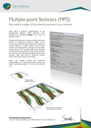
White Paper<br />
Drill Hole Spacing<br />
Analysis<br />
Geostatistical Assessment of<br />
Borehole Spacing Relative <strong>to</strong><br />
Resource Confidence
Drill Hole Spacing Analysis<br />
Geostatistical Assessment of Borehole Spacing<br />
Relative <strong>to</strong> Resource Confidence<br />
Use your data <strong>to</strong> inform and support your resource<br />
classification and drilling decisions.<br />
Not all coal seams and quality variables have <strong>the</strong> same continuity or variability, so investigating<br />
drill hole spacing for your data makes sense.<br />
Drill Hole Spacing Analysis (DHSA) lets you understand variations in estimation precision across<br />
your deposit for different seams, domains and variables.<br />
Many deposits, variables, and most importantly, a range of geological settings have been analysed<br />
using DHSA <strong>to</strong> obtain <strong>the</strong> optimal drill spacing information <strong>to</strong> support resource classification<br />
decisions.<br />
DHSA has been implemented internationally by <strong>Geovariances</strong> for over 12 years. In Australia, DHSA<br />
has been applied <strong>to</strong> coal operations and projects in <strong>the</strong> Bowen, Surat and Gunedah Basins.
Variability in coal quality<br />
Continuity and variability are unique for each coal seam and<br />
deposit. So why apply <strong>the</strong> same drill hole spacings for resource<br />
classification at different mine sites or even across a deposit<br />
Does your resource<br />
classification process<br />
reflect <strong>the</strong> variability<br />
you see at your<br />
operation<br />
The Coal Guidelines for coal resource classification are based on<br />
<strong>the</strong> perceived precision of estimates. The recommended spacings<br />
apply <strong>to</strong> all seams, variables, coal measures and geological<br />
settings. These spacings do not consider <strong>the</strong> continuity and<br />
variability of <strong>the</strong> individual coal seams or plies, nor <strong>the</strong> specific<br />
geology.<br />
If you have sufficient drilling data <strong>to</strong> understand <strong>the</strong> continuity<br />
and variability of coal properties for your site, why not use it <strong>to</strong><br />
assist with operational decisions, like resource classification,<br />
product specifications or drilling optimisation<br />
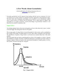
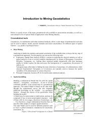
Fig. 1 - The spatial continuity of a deposit is captured in a DHSA study<br />
thanks <strong>to</strong> variography.<br />
DHSA - an objective measure<br />
Objectively inform<br />
your resource<br />
classification and<br />
drilling decisions.<br />
DHSA provides a geostatistical means of assessing <strong>the</strong> estimate<br />
precision for coal resource estimates based on <strong>the</strong> sampling data<br />
and its geostatistical properties. The DHSA results can be used <strong>to</strong><br />
objectively inform your resource classification and drilling<br />
decisions.<br />
DHSA results can be used <strong>to</strong>:<br />
References<br />
Coalfields Geology Council of<br />
New South Wales and <strong>the</strong><br />
Queensland Mining Council,<br />
2003 Australian guidelines for<br />
estimating and reporting of<br />
Inven<strong>to</strong>ry Coal, Coal Reserves<br />
O. Ber<strong>to</strong>li (<strong>Geovariances</strong>), C.<br />
Mawdesley (<strong>Geovariances</strong>), S.<br />
Martinez (BMA), A. Paul<br />
(formerly BMA), D. Dunn (BMA),<br />
2012 - "Measure for Measured -<br />
Geostatistical coal resource<br />
classification in <strong>the</strong> Bowen<br />
Basin", 34th Int. Geol. Congress,<br />
Brisbane 5-10 August 2012<br />
Support changes <strong>to</strong> resource classification.<br />
Prioritise drilling targets by identifying areas requiring<br />
increased or reduced sampling density.<br />
Indicate fur<strong>the</strong>r drilling required <strong>to</strong> attain a given resource<br />
classification. This can be critical in budget planning for<br />
project development.<br />
Suggest grade control drill densities required <strong>to</strong> capture <strong>the</strong><br />
short-term variability <strong>to</strong> meet mill or product specifications.<br />
Compare different domains and seams or plies <strong>to</strong> identify<br />
areas of greater variability (or insufficient data) that require<br />
C<br />
o<br />
a
fur<strong>the</strong>r work <strong>to</strong> define or mitigate <strong>the</strong> potential impact of high<br />
variability on planned mine production.<br />
Through DHSA, use<br />
your data <strong>to</strong><br />
understand, inform<br />
and support your<br />
resource classification<br />
decisions.<br />
The use of a geostatistical method, where <strong>the</strong> classification of a<br />
resource is driven by <strong>the</strong> actual in situ variability of <strong>the</strong> given<br />
resource, is strongly recommended as best practice for <strong>the</strong><br />
industry (Ber<strong>to</strong>li et al, 2012).<br />
Benefits<br />
The principal benefit of DHSA is gained from using your data and<br />
its characteristics <strong>to</strong> develop site-specific resource classification<br />
recommendations.<br />
DHSA is repeatable and objective, which can be crucial as projects<br />
progress and drilling is updated.<br />
Experience shows that DHSA spacing recommendations for<br />
resource classifications can differ significantly from <strong>the</strong> Coal<br />
Guidelines.<br />
DHSA methodology<br />
DHSA is a geostatistical technique that uses <strong>the</strong> global estimation<br />
variance <strong>to</strong> calculate <strong>the</strong> precision levels for various sample<br />
densities for a specific deposit.<br />
Firstly, explora<strong>to</strong>ry data analysis and variography are completed<br />
for <strong>the</strong> available sampling data (and where appropriate, domaining<br />
may also be applied <strong>to</strong> achieve stationarity).<br />
Benchmarking DHSA<br />
The precision of <strong>the</strong> DHSA<br />
results have been<br />
benchmarked against a<br />
suite of conditional cosimulations<br />
(CCS). The<br />
DHSA spacings were in very<br />
close agreement with CCS<br />
results over periods<br />
equating <strong>to</strong> five years of<br />
production.<br />
<strong>Geovariances</strong> recommend<br />
using DHSA instead of<br />
conditional simulation<br />
approaches for <strong>the</strong><br />
significant time savings and<br />
relative simplicity.<br />
The continuity and variability of a specific area and variable are<br />
characterised by <strong>the</strong> variogram model. DHSA uses <strong>the</strong> variogram<br />
model <strong>to</strong> determine <strong>the</strong> estimation variance for a single block.<br />
The annual area mined (or uncovered) is required as an input in<strong>to</strong><br />
<strong>the</strong> DHSA process. This gives <strong>the</strong> size of <strong>the</strong> area for <strong>the</strong> global<br />
estimate.<br />
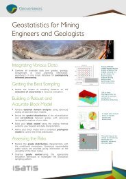
Fig. 2 - Calculating global estimation variance
Global Estimation Precision<br />
Many different drill spacings (e.g. block sizes) are tested, with <strong>the</strong><br />
global estimation variance calculated based on <strong>the</strong> <strong>to</strong>tal area and<br />
<strong>the</strong> number of drill holes that will cover that area at a specified<br />
drill spacing. This analysis is repeated for many different sample<br />
spacings and <strong>the</strong> global estimation variances are used <strong>to</strong><br />
approximate <strong>the</strong> precision.<br />
Current coal industry<br />
practice for coal<br />
resource classification<br />
is <strong>to</strong> derive global<br />
estimation precisions<br />
for <strong>the</strong> variables<br />
thickness and ash over<br />
a five year period and<br />
apply <strong>the</strong> following<br />
resource categories:<br />
Measured 20%<br />
Drill Hole Spacing (m)<br />
Fig. 3 - DHSA utilises <strong>the</strong> site variability (captured by <strong>the</strong> variogram model)<br />
<strong>to</strong> recommend drill spacings for resource classification<br />
Drill hole spacings are determined for a defined global estimation<br />
precision.<br />
In <strong>the</strong> example above, for Raw Ash, if a measured coal resource is<br />
assigned as having a global estimation precision lower than 10%<br />
over a 5 year period, a DHSA study advises a drill hole spacing of<br />
900 metres.<br />
Case S<strong>to</strong>ry for <strong>the</strong><br />
Bowen basin<br />
DHSA is typically carried out for a range of variables, including<br />
thickness, ash, volatiles, sulphur and phosphorous. DHSA will<br />
provide a separate drill hole spacing recommendation for each<br />
variable investigated. The DHSA results for all variables will not<br />
have equal weighting or consideration for resource classification.<br />
Current coal industry practice for coal resource classification is <strong>to</strong><br />
consider global estimation precisions obtained from DHSA for <strong>the</strong><br />
variables thickness and ash.<br />
DHSA has been used at 14<br />
of BHP Billi<strong>to</strong>n Mitsubishi<br />
Alliance (BMA) coal<br />
operations and projects in<br />
<strong>the</strong> Bowen Basin. The DHSA<br />
results suggest that in <strong>the</strong><br />
Rangal Coal Measures, <strong>the</strong><br />
Coal Guidelines are<br />
probably <strong>to</strong>o strict for<br />
Indicted Resources (Ber<strong>to</strong>li<br />
et al, 2012).<br />
THICKNESS<br />
MEASURED<br />
(±10%)<br />
INDICATED<br />
(±20%)<br />
INFERRED<br />
(±50%)<br />
Drill hole Spacing Required – Rounded down<br />
Seam/Domain <strong>the</strong> closer 50 meters (area equivalent <strong>to</strong> 5<br />
years production)<br />
THICKNESS 2,000 3,650 7,650<br />
RAW ASH 900 1,700 3,100<br />
WASHED ASH 1,200 2,250 4,700<br />
With DHSA results like <strong>the</strong>se, would you reconsider your resource<br />
classification decisions and drilling decisions You should.
Our expertise<br />
Who is <strong>Geovariances</strong><br />
<strong>Geovariances</strong> is a specialist<br />
geostatistical consulting and<br />
software company. We have<br />
over 45 staff, including<br />
specialist mining consultants<br />
and statisticians.<br />
Our software, Isatis, is <strong>the</strong><br />
accomplishment of 25 years of<br />
dedicated experience in<br />
geostatistics. It is <strong>the</strong> global<br />
software solution for all<br />
geostatistical questions.<br />
O<strong>the</strong>r technical specialties<br />
<strong>Geovariances</strong> are world leaders<br />
in developing and applying new<br />
and practical geostatistical<br />
solutions <strong>to</strong> mining operations.<br />
We have strong experience in<br />
all commodities, and have<br />
gained trust from <strong>the</strong> biggest<br />
international companies.<br />
Our expertise is in applying<br />
geostatistics <strong>to</strong> resource<br />
evaluation. Our services are<br />
through consulting, training,<br />
and software.<br />
<strong>Geovariances</strong> has 12 years of experience in DHSA projects. Most<br />
of <strong>the</strong> work has been performed for <strong>the</strong> Australian coal industry.<br />
We can provide a unique expertise through both our French and<br />
Australian offices.<br />
<strong>Geovariances</strong> is dedicated <strong>to</strong> applied geostatistics and has set <strong>the</strong><br />
standards in geosciences, providing <strong>the</strong> mining industry with <strong>the</strong><br />
Isatis software for more than 25 years.<br />
For more information<br />
Let us help you understand <strong>the</strong> variability and continuity of your<br />
coal deposit and use <strong>the</strong> global precisions and drill spacings <strong>to</strong><br />
refine your resource classification and drilling decisions.<br />
Contact our consultants:<br />
In Australia, Clare Mawdesley:<br />
mawdesley@geovariances.com<br />
In France, Olivier Ber<strong>to</strong>li:<br />
ber<strong>to</strong>li@geovariances.com<br />
h<br />
o<br />
a<br />
r<br />
e<br />
<strong>Geovariances</strong><br />
49 bis, av. Franklin Roosevelt<br />
BP91 - 77212, Avon Cedex<br />
France<br />
T +33 1 60 74 90 90<br />
F +33 1 64 22 87 28<br />
PO Box 979<br />
Wynnum, QLD 4178<br />
Australia<br />
T +61 7 33 48 53 33<br />
F +61 7 33 48 53 55<br />
www.geovariances.com<br />
G<br />
e<br />
o<br />
v<br />
a<br />
r<br />
i<br />
a<br />
n<br />
c<br />
e<br />
s<br />
<br />
G<br />
e<br />
o<br />
v<br />
a<br />
r<br />
i<br />
a<br />
n<br />
c<br />
e<br />
s