Isatis - Geovariances
Isatis - Geovariances
Isatis - Geovariances

You also want an ePaper? Increase the reach of your titles
YUMPU automatically turns print PDFs into web optimized ePapers that Google loves.
ISATIS<br />
NEWS<br />
The Universe<br />
Of Geostatistics<br />
Editorial<br />
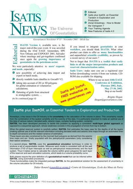
<strong>Isatis</strong> plus IsatOil, an Essential<br />
Tandem in Exploration and<br />
Production<br />
Zonal Anisotropy : How to Model<br />
the Variogram <br />
Your Training Agenda<br />
New Features of <strong>Isatis</strong> 4.0<br />
<strong>Geovariances</strong> Newsletter N°13 – November 2001 – Oil & Gas<br />
Editorial<br />
ISATIS Version 4 , available now, is the<br />
major end-of-the-year event. It was unveiled<br />
during the 63rd EAGE Amsterdam, SPE<br />
New Orleans and EXPOGEF 2001, Salvador<br />
where meetings and get-togethers confirmed<br />
once again the growing importance of<br />
geostatistics in the petroleum sector.<br />
We were particularly attentive to users' requests<br />
and needs ,<br />
especially:<br />
new possibility of achieving data import and<br />
export in batch mode;<br />
directly readable <strong>Isatis</strong> datafiles in Gocad® V2;<br />
taking into account of 2D or 3D polygons<br />
for global estimation or volumetrics<br />
calculations;<br />
flattening of grids from structural<br />
to stratigraphic system; …<br />
(to be continued page 4)<br />
If you intend to integrate geostatistics in your<br />
workflow, you should think ISATIS. What other<br />
product can claim to offer so many functionalities<br />
and unparalleled scientific credibility, as proven by<br />
a recent survey of our users <br />
Not to forget that ISATIS is a toolkit that easily<br />
links to all the major interpretation products and<br />
reservoir characterization suites.<br />
<strong>Isatis</strong> Users : make sure you are a registered user<br />
before downloading version 4 from our website. CD-<br />
ROM also available for shipping.<br />
Where to see us next: 64th EAGE<br />
Conference & Exhibition,<br />
Florence 2002, Italy,<br />
May 27-30, 2002.<br />
Stop at our booth!<br />
Brigitte Hogan<br />
(hogan@geovariances.com)<br />
<strong>Isatis</strong> plus IsatOil, an Essential Tandem in Exploration and Production<br />
Nowadays, a key issue in the Oil Industry is the uncertainty in the calculation of the volume in place. This uncertainty results<br />
from the combination of the spatial variability and the scarcity of the data. It is particularly important to make an optimal use of<br />
the data of various nature ( deviated wells, seismic maps, complex faulting system, contacts).<br />
ISATOIL has been developed precisely to tackle this problem by applying a consistent multi-layer global approach as<br />
opposed to a sequential approach, whose weakness consists in the propagation of errors from top to bottom.<br />
When the global reservoir system is carefully settled, ISATOIL first estimates the base case for the depths of all the layers<br />
(making optimal use of all the relevant information including deviated wells and seismic time maps through an automated timeto-depth<br />
conversion) and the related variance of estimation.<br />
These layers are also constrained by the (normal) fault polygons as derived from the seismic<br />
time maps and are finally populated with the petrophysical parameters (only considering<br />
their lateral variations).<br />
In a second phase, ISATOIL uses the geostatistical simulation technique in order to<br />
produce a set of equiprobable models. Moreover each model is consistent with all the well<br />
information (TVD of layer intercepts as well as petrophysical measurements) and the fault<br />
system. Thus it makes sense to calculate the volume (within given polygons) for each layer<br />
of the reservoir and each simulation outcome, which leads to a volume probability curve.<br />
Both phases require the prior definition of a geostatistical model that can be inferred within<br />
ISATOIL using automated procedures.<br />
These functionalities make the integrated package ISATOIL be the geostatistical solution for the assessment of uncertainty in<br />
the volume calculation for Oil industry.<br />
Didier Renard (renard@cg.ensmp.fr -Centre de Géostatistique, Ecole des Mines de Paris)<br />
49 bis avenue Franklin Roosevelt – BP91 – 77212 Avon Cedex, France – Phone : +33 (0) 60 74 90 90 – Fax : +33 (0) 1 64 22 87 28 – www.geovariances.com<br />
1
ISATIS<br />
NEWS<br />
The Uniiverse<br />
Of Geostatiistiics<br />
Consulting<br />
consulting@geovariances.com<br />
Zonal anisotropy: how to model the variogram<br />
W h e n t h e e x p e r i m e n t a l v a r i o g r a m s s h o w d i f f e r e n t<br />
b e h a v i o r s i n d i f f e r e n t d i r e c t i o n s a n a n i s o t r o p i c v a r i o g r a m<br />
m o d e l s h o u l d b e f i t t e d t o t h e m . T h e r e a r e h o w e v e r s o m e<br />
p r a c t i c a l d i f f i c u l t i e s i n f i t t i n g t h e m o s t a p p r o p r i a t e m o d e l .<br />
T h e s e d i f f i c u l t i e s c a n l e a d t o a w r o n g m o d e l o f t h e t r u e<br />
u n d e r l y i n g s t r u c t u r e . W h e n t h e d i r e c t i o n a l v a r i o g r a m s<br />
s h o w d i f f e r e n t v a r i a b i l i t y f o r t h e d i f f e r e n t d i r e c t i o n s t h e<br />
s i l l s a r e n o t c o m p a r a b l e . I n s u c h a c a s e g e o s t a t i s t i c s c a n<br />
b e u s e d t o e s t a b l i s h a v a r i o g r a m m o d e l m a d e u p o f<br />
c o m p o n e n t s h a v i n g a s o - c a l l e d " z o n a l " a n i s o t r o p y .<br />
L e t ' s d e s c r i b e t h e p r o c e d u r e t o b e f o l l o w e d f o r c a l c u l a t i n g<br />
a n d f i t t i n g a v a r i o g r a m m o d e l w i t h z o n a l a n i s o t r o p y b y<br />
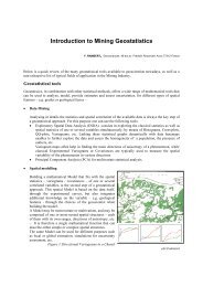
m a k i n g u s e o f s o m e b a t h y m e t r i c d a t a , k i n d l y p r o v i d e d b y<br />
I F R E M E R (I n s t i t u t F r a n ç a i s d e R e c h e r c h e p o u r<br />
l ’ E x p l o i t a t i o n d e l a M e r ) .<br />
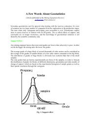
F i g u r e 2 s h o w s t h e v a r i o g r a m s c a l c u l a t e d a l o n g N 1 0 W<br />
a n d N 8 0 E a n d t h e m o d e l t h a t h a s b e e n f i t t e d . A v a r i o g r a m<br />
w i t h a z o n a l c o m p o n e n t i s r e q u i r e d h e r e . T o s i m p l i f y t h e<br />
f i t t i n g p r o c e d u r e , t w o d i r e c t i o n s h a v e b e e n f i t t e d<br />
i n d e p e n d e n t l y . T h a t m e a n s t h a t t h e r e s u l t i n g 2 D m o d e l<br />
h a s t h e f o l l o w i n g f o r m ( w h e r e u a n d v r e p r e s e n t t h e t w o<br />
m a i n d i r e c t i o n s o f a n i s o t r o p y ) :<br />
γ ( hu<br />
, hv<br />
) = γ<br />
1<br />
( hu<br />
) + γ<br />
2<br />
( hv<br />
)<br />
here g(2D)=Gauss(along N10W,200m)<br />
+Spherical(along N80E,500m)<br />
Figure 2: Experimental and modeled variogram<br />
in the 2 main directions of anisotropy<br />
Figure 1: Base map of the bathymetric data<br />
T h e d a t a s h o w n o n f i g u r e 1 c o m e s f r o m a b a t h y m e t r i c<br />
s u r v e y o r i g i n a l l y c o n d u c t e d b y t h e F r e n c h h y d r o g r a p h i c<br />
s u r v e y ( S H O M ) c o v e r i n g a n a r e a o f a p p r o x i m a t e l y 8 k m x<br />
5 k m a l o n g t h e S p a n i s h a n d F r e n c h m e d i t e r r a n e a n c o a s t .<br />
D e s p i t e t h e n o n s t a t i o n a r i t y o f t h e d e p t h w h e n m o v i n g<br />
a w a y f r o m t h e w a s t l i n e , t h e s a m p l i n g d e n s i t y a u t h o r i z e s<br />
t o u s e v a r i o g r a m s w i t h i n a l i m i t e d n e i g h b o r h o o d . S o w e<br />
h a v e t o c a l c u l a t e a n d m o d e l d i r e c t i o n a l v a r i o g r a m s .<br />
T h e f i r s t t h i n g t o d o i s t o i d e n t i f y t h e 2 d i r e c t i o n s s h o w i n g<br />
t h e m i n i m u m a n d m a x i m u m s p a t i a l c o n t i n u i t y . T h e<br />
v a r i o g r a m m a p m a y h e l p d e t e r m i n e t h e s e d i r e c t i o n s .<br />
T h i s m o d e l i s " a u t h o r i z e d " a n d f i t s w e l l t h e t w o m a i n<br />
d i r e c t i o n s , b e c a u s e t h e g a u s s i a n c o m p o n e n t h a s n o e f f e c t<br />
a l o n g N 8 0 E a n d c o n v e r s e l y t h e s p h e r i c a l c o m p o n e n t i s<br />
n o t p r e s e n t a l o n g N 1 0 W . H o w e v e r t h i s m o d e l i s n o t<br />
s a t i s f a c t o r y a l o n g i n t e r m e d i a t e d i r e c t i o n s , a s s h o w n i n t h e<br />
l e f t h a n d g r a p h i c o f t h e f i g u r e 3 .<br />
T h e m o d e l a l o n g t h e b i s e c t i n g d i r e c t i o n N 3 5 E i s g r e a t e r<br />
t h a n t h e m o d e l i n N 8 0 E d i r e c t i o n , w h i c h i s s u p p o s e d t o b e<br />
t h e d i r e c t i o n o f g r e a t e s t v a r i a b i l i t y ! ! !<br />
T h e r i g h t a p p r o a c h t o m o d e l a l l d i r e c t i o n s c o n s i s t e n t l y<br />
w i t h t h e o b s e r v a t i o n s m a d e o n t h e t w o m a i n d i r e c t i o n s o f<br />
v a r i a b i l i t y w i l l c o n s i s t i n f i t t i n g a m o d e l w i t h t w o<br />
c o m p o n e n t s : t h e f i r s t c o m p o n e n t i s i s o t r o p i c a n d t h e<br />
s e c o n d z o n a l a n i s o t r o p i c .<br />
More publications on www.geovariances.com<br />
2
ISATIS<br />
NEWS<br />
The Uniiverse<br />
Of Geostatiistiics<br />
Training<br />
training @geovariances.com<br />
Figure 3: Variograms in the 2 main directions of anisotropy<br />
+ a bisecting direction<br />
T h e s i l l o f t h e s e c o n d c o m p o n e n t i s e q u a l t o t h e d i f f e r e n c e<br />
b e t w e e n t h e s i l l s o b s e r v e d a l o n g t h e m a i n d i r e c t i o n s o f<br />
c o n t i n u i t y :<br />
2<br />
2<br />
γ ( h<br />
, h<br />
) = γ<br />
( h<br />
)<br />
(<br />
)<br />
u v<br />
1 u + h v + γ h<br />
2 v<br />
I n t h e f i r s t m o d e l t h e t o t a l s i l l i s i n f a c t t h e s u m o f t h e<br />
c o m p o n e n t s i l l s i n b o t h d i r e c t i o n s . I n t h e s e c o n d m o d e l<br />
t h e t o t a l s i l l a l w a y s l i e s b e t w e e n t h e s i l l o f t h e i s o t r o p i c<br />
c o m p o n e n t a n d t h e s i l l f i t t e d t o t h e v a r i o g r a m i n t h e<br />
d i r e c t i o n o f m a x i m u m v a r i a b i l i t y ( v ) .<br />
T o f i t s u c h a m o d e l t h a t i s c o r r e c t f o r a l l d i r e c t i o n s s o m e<br />
c o m p r o m i s e s m u s t b e m a d e a l o n g t h e t w o m a i n d i r e c t i o n s<br />
N 8 0 E a n d N 1 0 W . I n o u r c a s e t h e r e s u l t i n g f i t ( s e e n o n t h e<br />
r i g h t h a n d g r a p h i c o f F i g u r e 3 ) i s m a d e u p o f :<br />
γ (2D)= Gaussian (isotropic,170m) +<br />
Linear(along N80E)<br />
W h i l e t h e c o n s e q u e n c e s o f t h e f i r s t m o d e l m a y b e n o t s o<br />
i m p o r t a n t w h e n k r i g i n g f r o m v e r y d e n s e d a t a l i k e i n o u r<br />
b a t h y m e t r i c s t u d y , t h e y m a y b e d i s a s t r o u s w h e n<br />
s i m u l a t i n g o r e s t i m a t i n g 3 D d a t a .<br />
Jacques Deraisme (deraisme@geovariances.com)<br />
Your training agenda for next year!<br />
Geostatistical Gridding for the Oil & Gas Industry January 21-23, 2002<br />
Oil & Gas, <strong>Isatis</strong> Essentials March 11-13, 2002<br />
Time to Depth Conversion, the Geostatistical Approach April 24-26, 2002<br />
Assessing Volumetrics Uncertainties: the Geostatistical Approach June 10-12, 2002<br />
Available upon request:<br />
Introduction to Geostatistics for Oil & Gas (5 days)<br />
First Steps into Geostatistics (3 days)<br />
Courses Description, Bookings: www.geovariances.com<br />
More info: training@geovariances.com<br />
3
ISATIS<br />
NEWS<br />
The Uniiverse<br />
Of Geostatiistiics<br />
Support<br />
support @geovariances.com<br />
Discover the new features of <strong>Isatis</strong> 4.0<br />
Import or Export your data in batch mode<br />
Run easily your import / export applications in batch:<br />
importing or exporting tasks may now be integrated in<br />
journal files just like for any other <strong>Isatis</strong> panel.<br />
Even better: all the data exchange interfaces are now<br />
available on Windows NT/2000/XP.<br />
Exchange your wells, surfaces, 3D grids,<br />
polygons or faults between <strong>Isatis</strong> and Gocad<br />
Gocad V2, developed by T-SURF (Nancy), now<br />
offers a direct read/write access to the <strong>Isatis</strong> database.<br />
Krige data or compute Volumetrics inside 2D<br />
or 3D Polygons<br />
More tools and flexibility in the handling of polygons in<br />
the new Polygon Editor: new algorithms for polygon<br />
consistency, intersection of polygons, management of<br />
polygons with holes, etc. have been added whilst the<br />
Polygon Display module enables the visualization of<br />
kriged results in combination with input data.<br />
Global estimation is now included: you can krige<br />
variables on complex objects that can be described<br />
with 2D or 3D polygons.<br />
In addition: Polygons are also taken into account in<br />
the Volumetrics application. Statistics or risk curves<br />
may be computed polygon by polygon or on the entire<br />
grid.<br />
Help Desk<br />
support@geovariances.com<br />
or call +33 (0)1 60 74 91 00<br />
… “You could give some other<br />
companies some lessons on how to<br />
provide technical support” …<br />
ANADARKO, UK<br />
… “Thank you very much for your<br />
prompt and useful answer” …<br />
PDVSA, VENEZUELA<br />
… “It’s a real pleasure to work<br />
together and to use <strong>Isatis</strong>” …<br />
ENTERPRISE OIL, UK<br />
3<br />
Transform your geometry from structural to<br />
stratigraphic system<br />
A dedicated new application has been designed for<br />
folding and unfolding of block systems: switch<br />
between the original depositional reference system and<br />
today's (X,Y,Z) coordinate system.<br />
Among other handy improvements:<br />
* Read and write ASCII files in CSV format (Comma<br />
Separated Values): data exchanges are definitely far<br />
much easier;<br />
* View Labels are now attached to graphic windows:<br />
give a title, add a note or specify parameters values in<br />
your views;<br />
* Measure distances and angles directly in most <strong>Isatis</strong><br />
graphic windows;<br />
* Use the Calculator more efficiently: save series of<br />
transformations in template files in order to use them<br />
again later on. Creating selection variables has also<br />
been added in this panel.<br />
Complete list of <strong>Isatis</strong> V4 features<br />
on www.geovariances.com<br />
Press<br />
F1 or Help<br />
from each window<br />
You do not know<br />
the meaning of a<br />
parameter<br />
You are unsure<br />
about the proper<br />
method to use<br />
Have you ever<br />
open the<br />
On-Line Help<br />
49 bis avenue Franklin Roosevelt – BP91 – 77212 Avon Cedex, France – Phone : +33 (0) 60 74 90 90 – Fax : +33 (0) 1 64 22 87 28 – www.geovariances.com<br />
4