Reporter No 60, May 2009, English (PDF 2,58 MB) - Leica ...
Reporter No 60, May 2009, English (PDF 2,58 MB) - Leica ...
Reporter No 60, May 2009, English (PDF 2,58 MB) - Leica ...

You also want an ePaper? Increase the reach of your titles
YUMPU automatically turns print PDFs into web optimized ePapers that Google loves.
on location, 5/8 " (16 mm) per 50 vertical feet (15 m)<br />
plumb and 1/8 " (3.2 mm) on elevation are met.<br />
The two <strong>Leica</strong> TCRA705 total stations continue to<br />
monitor for settlement and/or column movement<br />
throughout the module construction, since such<br />
movements might cause the structural steel to be out<br />
of tolerance. Engineers check the tolerances every<br />
morning, and prescribe the proper adjustments so as<br />
not to hold up production.<br />
Scanned alternatives<br />
Once a module's beam and plate foundation is in<br />
place, structural crews begin to piece the components<br />
together at the module's lowest level, based<br />
upon the specifications contained in the work package.<br />
Every work package includes pre-defined pipes<br />
and other components.<br />
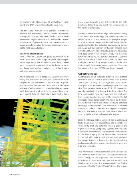
When a module level is complete, Cianbro surveyors<br />
verify the positional location and accuracy of each<br />
This information is then compared to the design values<br />
acquired from the owner's pre-determined theoretical<br />
design. If the engineers find a variance out<br />
of tolerance, they note the pipe end or structural<br />
steel values and relay the information to the Quality<br />
Assurance/Quality Control (QA/QC) team. The approcomponent<br />
per the owner's specifications. In previous<br />
situations that required field verifications such<br />
as these, Cianbro relied on conventional tapes, automatic<br />
levels and total stations to gather the necessary<br />
spatial data. It's typically a long and tedious<br />
process which would prove detrimental to the tight<br />
timelines defined by the client for construction of<br />
the refinery's modules.<br />
Instead, Cianbro turned to high definition scanning,<br />
a relatively new technology that allows surveyors to<br />
create highly accurate, measurable 3D digital images<br />
of a structure or scene, quickly and easily. Studies<br />
conducted by Cianbro indicated that scanning a module<br />
would cut the position verification process from<br />
days to just hours, while providing improved accuracy<br />
and data consistency. In early 2008, the manufacturer<br />
purchased its first <strong>Leica</strong> ScanStation 2 scanner<br />
able to provide full 3<strong>60</strong> ° x 270 ° field of view from<br />
a single scan and long range accuracy to six millimeters,<br />
with 300-meter maximum range. The <strong>Leica</strong><br />
ScanStation 2 fires at 50’000 points per second.<br />
Collecting clouds<br />
As structural crews complete a module level, Cianbro<br />
surveyors set up the HDS ScanStation 2 on a tripod<br />
and begin scanning. A scan typically covers about<br />
one-quarter of a module depending on the module's<br />
size. That process takes about 15 to 30 minutes to<br />
complete and will record some 1.5 million points. The<br />
field engineering crew then moves to the next position<br />
to scan another portion of the module. The full<br />
verification scan takes about two hours as the scanner<br />
is moved four to six times to ensure complete<br />
coverage of the module. The crew uses a traverse<br />
method to collect, constrain, and register a 3D point<br />
cloud of the entire module. The data is then tied<br />
directly to the site's local coordinate system.<br />
Once the 3D scan data is collected, the ScanStation 2<br />
technicians map the information into a single file.<br />
They verify that the collected data is precise and<br />
highly accurate by using <strong>Leica</strong> Cyclone 6.0 and <strong>Leica</strong><br />
Cloudworx 4.0 software. The database created within<br />
the team's laptop in the field is then transferred<br />
to the Dell XPS desktop, which is also equipped with<br />
the proper Cyclone software for the final rendering<br />
and geospatial referencing of the structural steel and<br />
pipe end locations.<br />
16 | <strong>Reporter</strong>