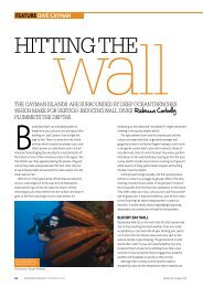
60-68-CAYMAN BRAC-V7 - Cayman Islands
60-68-CAYMAN BRAC-V7 - Cayman Islands
60-68-CAYMAN BRAC-V7 - Cayman Islands

Create successful ePaper yourself
Turn your PDF publications into a flip-book with our unique Google optimized e-Paper software.
1. West End Point Outlook – Watch birds, the sea and the sunset looking<br />
towards Little <strong>Cayman</strong>.<br />
2. Westerly Ponds (west and east ) – On the southwest shore, use board<br />
walks and viewing areas to observe over 100 species of birds on the wetlands.<br />
3. Salt Water Pond – A sanctuary at the junction of South Side Road and Gerrard<br />
Smith Road; seasonal birdwatching, least tern colony, April-August.<br />
4. To Rebecca’s Cave/Salt Water Pond Walk – Follow sign on Rebecca’s Road<br />
at junction with South Side Road.<br />
5. Rebecca’s Cave Historic Site – This cave was once used as a hurricane shelter.<br />
6. Salt Water Pond Walk – A hike from the south to the north coast, beside<br />
Rebecca’s Cave; birdwatching and tropical plants. A strenuous hike.<br />
Level: moderate to rough.<br />
7. Salt Water Pond Walk – No. 6 in reverse, from the north coast at White Bay<br />
to the south coast.<br />
8. The Marshes Wetlands – on South Side Road West, near Public Beach;<br />
birdwatching and the Red Shrimp Hole.<br />
9. Bat Cave – In the bluff on South Side Road West.<br />
10. Beach Walk to First Cay – A robust walk from the end of the road along the<br />
southeast shore below the bluff to the large rock (First Cay); only serious<br />
climbers should proceed further as rough seas are a hazard. Brown Booby,<br />
Frigate birds and Migrant Tropic birds from January to August.<br />
Return trip 2 hours. Level: easy to moderate.<br />
11. Walk to Windlass of S.S. Kersearge – Pass the airport entrance and continue<br />
on West End Road West, turn right onto James Scott Road, cross Georgiana<br />
Drive to the sea. The windlass (18<strong>60</strong> ship’s winch) lies on the Ironshore to your<br />
right. To complete a loop walk, follow signs east along the shore and return<br />
to the main road by Robert Foster Lane. Swimming at Buccaneer Barcadere.<br />
Beware sharp drop off. Level: easy.<br />
12. Deadman’s Point Bluff Road – Climb the bluff steps on the north coast (east<br />
of the Museum) to hike through endemic woodland to Songbird Drive; endemic<br />
birds and plants. Return 1.5 hours. Level: moderate.<br />
13. Deadman’s Point Bluff Road – as 12 in reverse direction, from Songbird<br />
Drive to north coast.<br />
13A. Deadman’s Point to Hemmington Road loop (and reverse) - At bluff, exit<br />
on Songbird Drive, follow signs to Hemmington Road and complete hike to north<br />
coast on second trail No.16 below. Return 2.5 hours. Level moderate to rough.<br />
14. Half Way Ground Cave – On the north coast east of Hemmington Road.<br />
15. Hemmington Road Hiking Trail – Climb the bluff steps on the north coast, east<br />
of Deadman’s Point Bluff Road; hike through endemic woodland to Songbird<br />
Drive; endemic birds and plants. Return 1.5 hours. Level: rough.<br />
16. Hemmington Road Hiking Trail – as No.15, in reverse direction,<br />
from Songbird Drive to north coast.<br />
17. Bight Road (north) – Climb the steps to the bluff on the<br />
north coast, east of Ashton Reid Drive; hike through<br />
ancient woodland along the boundary of the<br />
23. Peter’s Cave – Traditional hurricane shelter for residents of Spot Bay,<br />
on Lighthouse Steps. Access also from top of the bluff via path from<br />
Peter’s Road car park.<br />
24. Peter’s Outlook – Panoramic view of Spot Bay, at the top<br />
of the Steps. Access on top of the bluff from Peter’s Road car park.<br />
25. Lighthouse Footpath – Via the Lighthouse Steps No. 22, past Peter’s<br />
Road car park on the bluff to Footpath entrance gate or by car via<br />
Major Donald Drive to Peter’s Road car park. Hike through shrubland<br />
onto wide path close to the bluff edge to the Lighthouse. Panoramic<br />
views, endemic vegetation and sea birds. Return by the same route<br />
or take a loop on the main Major Donald Drive to Peter’s Road car park.<br />
Boots and water essential. Return 3 hours. Level: moderate.<br />
26. Little <strong>Cayman</strong> Brac Outlook – Overlook the cay (large rock) half way<br />
along the Lighthouse Footpath No. 25. Brown Booby breed in caves<br />
and ledges in the bluff below. Level: easy.<br />
27. Lighthouse – Panoramic ocean views and sea birds.<br />
Maintain a safe distance and beware of edge!<br />
28. Long Beach – Follow path to the shore through seagrape at the east<br />
end of the north coast road; dramatic walk below bluff. Climbers only<br />
can continue further east but beware of rough seas.<br />
Return to the end of the beach 1.5 hours. Level: easy to moderate.<br />
29. <strong>Cayman</strong> Brac Community Park – On West End Road, west of the<br />
airport. Picnics and short walks.<br />
30. Pioneer Walk – Loop walk at West End. Follow Pioneer Lane to the<br />
sea, there is a sandy beach to the west, turn east along a hurricane<br />
boulder path and return on a track to the main road; bird watching.<br />
One hour. Level: easy.<br />
31 National Trust House – On White Bay Road; near the sea.<br />
32. Mass Gravesite – From the 1932 hurricane, close to the Trust House.<br />
33. Stake Bay Walk – Take Ryan’s Drive to Stake Bay Front Road, pass<br />
JA Ryan Cemetery, the landing place (original harbour for schooners)<br />
and historic houses, return via Kirkconnell Street and the Museum<br />
No. 34 to the main road.<br />
34. <strong>Cayman</strong> Brac Museum - Stake Bay – The oldest Museum in the <strong>Cayman</strong><br />
<strong>Islands</strong>, is located in the old Government Building which housed all the<br />
major departments and today allows residents and visitors the opportunity<br />
of “Keeping in touch with the past”. Phone: 948-2222 ext. 4446<br />
Hours: Mon. to Fri. 9am-12 noon, 1pm - 4pm; Sat. 9am - 12 noon.<br />
N<br />
55<br />
HERITAGE SITES & NATURE TRAILS — <strong>CAYMAN</strong> <strong>BRAC</strong><br />
st<br />
Parrot Reserve to Major Donald Drive on the mid bluff; endemic birds<br />
and plants. Return 1.5 hours. Level: moderate to rough.<br />
18. Bight Road (north) – as No.17, in reverse direction, from Major Donald Drive<br />
to the north coast. Return 1.5 hours. Follow the <strong>60</strong>0 ft. boardwalk through<br />
the tropical forest.<br />
19. Bight Road (south) – Hike from Major Donald Drive to the south bluff edge.<br />
Return 1.5 hours. Return hike from north to south coast — 3 hours.<br />
Level: moderate to rough.<br />
20. National Trust Parrot Reserve and Nature Trail – A short hike off Bight<br />
Road south; protected for breeding parrots, endemic plants and its<br />
biodiversity in 280 acres of ancient forest. Level: easy to moderate.<br />
21. Big Channel Road Outlook – Historic steps up the north face of the bluff, west of<br />
Spot Bay. Follow path from main road; panoramic views. Level: moderate.<br />
22. Lighthouse Steps – In Spot Bay, follow signs on Lighthouse Road to the<br />
historic steps up the northeast face of the bluff No. 25. Return hike to the<br />
lighthouse on the eastern bluff. 3 hours minimum. Level: moderate.<br />
35. Spot Bay Community Park – Beach<br />
picnics, swimming. Beware sharp drop off.<br />
36. <strong>Cayman</strong> Brac Heritage House – Weekly displays<br />
by local artisans, tours of the grounds and various cultural<br />
events. Hours: Mon. to Fri. 9:30 am - 1 pm, 2 pm - 5 pm; Sat. 10 am - 3 pm.<br />
Phone: 948-0653<br />
37. Spellman McLaughlin Historic House.<br />
38. Captain Charlie Kirkconnell’s Historic House.<br />
39. Christoper Columbus Gardens – Located on the Bluff, the park was the<br />
vision of the <strong>Cayman</strong> Brac Quincentennial Committee and is the home<br />
of the Wall of Honour, a relief of Christopher Columbus and several<br />
boardwalks and gazeboes constructed to fit in with the natural surroundings.<br />
40. Agriculture Grounds.<br />
41. Heritage Designs – Labyrinth, Iguanas, Cave, Mini Nature Trail,<br />
Night Sky Tours. Hours: Mon., Fri., Sat. 10 am - 5:30 pm.<br />
42. MV K.P. Tibbetts – Swimming, Dive/Snorkel. Access from Robert<br />
Foster Lane, site of Old Buccaneers Inn; first <strong>Cayman</strong> Brac Hotel.<br />
43. Nani Cave – Located inland, off Songbird Drive.<br />
44. Great Cave – Located on the south coast at the end of the paved road.<br />
For all emergency services, dial 911.