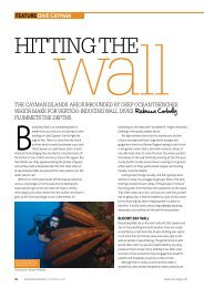
60-68-CAYMAN BRAC-V7 - Cayman Islands
60-68-CAYMAN BRAC-V7 - Cayman Islands
60-68-CAYMAN BRAC-V7 - Cayman Islands

Create successful ePaper yourself
Turn your PDF publications into a flip-book with our unique Google optimized e-Paper software.
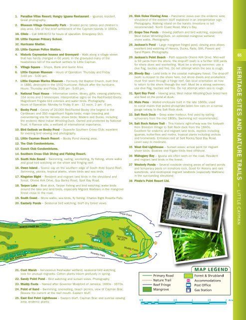
1. Paradise Villas Resort; Hungry Iguana Restaurant – Iguanas resident.<br />
Great photography.<br />
2. Blossom Village Community Park – Shaded picnic tables and children’s<br />
play area. Site of first brief settlement of the <strong>Cayman</strong> <strong>Islands</strong> in 16<strong>60</strong>s.<br />
3A. Clinic – Call 948-0072 for hours of operation. Emergency 911.<br />
3B. Little <strong>Cayman</strong> Primary School.<br />
3C. Hurricane Shelter.<br />
3D. Little <strong>Cayman</strong> Police Station.<br />
4. Historic <strong>Cayman</strong>ian houses and Graveyard – Walk along a village street<br />
that has hardly changed in <strong>60</strong> years. In the graveyard many of the<br />
headstones tell of the earliest settlers to Little <strong>Cayman</strong>.<br />
5. Village Square – Shops, Bank and Guest Area.<br />
6. Little <strong>Cayman</strong> Museum – Hours of Operation: Thursday and Friday<br />
3:00 pm - 5:00 pm.<br />
7. Little <strong>Cayman</strong> Marine Museum – Formerly Old Baptist Church, built first<br />
in 1886, destroyed in the 1932 hurricane. Rebuilt after the hurricane.<br />
Hours: Thursday and Friday 3:00 pm - 5:00 pm.<br />
8. National Trust House – Information centre, library, gifts; viewing platforms,<br />
334 acres and 3 telescopes. Interpretative signs on the Red-Footed Booby.<br />
Magnificent Frigate bird colonies and water birds. Photography.<br />
Hours of Operation: Monday to Friday 9 am - 12 noon, 2 pm - 6 pm.<br />
9. Booby Pond – Colony of 20,000 Red-Footed Booby (the largest in the<br />
Caribbean) and 350 magnificent frigate birds; major breeding and<br />
overwintering site for Herons, shore birds, Waders and Ducks, including<br />
the endemic West Indian Whistling-Duck. Owned and protected by National<br />
Trust. A Ramsar site; a wetland of international importance.<br />
10. Bird Outlook on Booby Pond – Opposite Southern Cross Club; excellent<br />
for evening bird viewing and photography.<br />
11. Little <strong>Cayman</strong> Beach Resort – Booby Pond viewing area.<br />
12. The Club Condominiums.<br />
13. Conch Club Condominiums.<br />
14. Southern Cross Club Diving and Fishing Resort.<br />
15. South Hole Sound – Swimming, sailing, snorkelling, fly fishing, shore walks<br />
and good bird watching on the shore and fringing reef.<br />
16. Owen Island – Scenic cay on the southern edge of South Hole Sound Reef.<br />
Swimming, picnics, tropical plants, shore birds and sea birds.<br />
17. Kingston Bight – Resident and migrant land birds in the shrubland and<br />
forest. Olivine Kirk Drive, Guy Banks Road, Spot Bay Road.<br />
18. Tarpon Lake – Boat dock, Tarpon fishing and bird watching; water birds<br />
around the lake and land birds, especially Migrant Warblers in the mangrove<br />
forest close to the road.<br />
19. South Coast – Shore walks, sea birds, fly fishing. Charles Bight Rosetta Flats.<br />
20. Easterly Ponds – Seasonal bird watching, bluff dry forest views.<br />
26. Sink Holes Viewing Area – Panoramic views over the endemic xeric<br />
shrubland of the eastern bluff explained in an interpretative sign.<br />
Photography. Walking inland on the karstic limestone is not<br />
recommended. North Coast Road, Mary’s Bay.<br />
27. Grape Tree Ponds – Viewing platform and bird watching, especially<br />
West Indian Whistling-Duck, on extended mangrove wetland;<br />
shore walks. Photography.<br />
28. Jackson’s Pond – Large mangrove fringed pond, viewing area allows<br />
excellent bird watching of Herons, Ducks, Rails, Stilt, Plovers and<br />
Sand Pipers. Photography.<br />
29. Jackson’s Point Beach – Path opposite Olivine Kirk Drive. Mini-wall<br />
is 50 yards from the shore; the drop-off (wall) is a further 100 yards<br />
for shore dives and snorkelling. Must be a strong swimmer; use a<br />
dive flag, booties and fins. Do not attempt when the sea is rough.<br />
30. Bloody Bay – Land birds in the coastal mahogany forest. The drop-off<br />
(wall) is closest to the shore here, but shore divers and snorkellers<br />
must first swim through a fringe reef. Get local orientation on how<br />
to return to the shore through the reef. Must be a strong swimmer;<br />
use dive flag, booties and fins. Do not attempt when sea is rough.<br />
31. Spot Bay Pond – Viewing area; West Indian Whistling-Duck breed here<br />
and feed on the pond at dusk.<br />
32. Mule Pens – Walled enclosure built in the late 1800s, used<br />
to corral mules that pulled phosphate-laden box cars on a narrow<br />
gauge railway to the Salt Rock dock.<br />
33. Salt Rock Dock – Deep water harbour, first used by sailing<br />
schooners from the mid 1800s. Swimming not recommended.<br />
34. Salt Rock Nature Trail – This historic right-of-way was the footpath<br />
from Blossom Village to Salt Rock dock from the 1840s.<br />
Excellent for endemic and migrant land birds, reptiles including<br />
iguanas, butterflies and moths, tropical plants including orchids<br />
and bromeliads. Entrance/exit at Salt Rocks/Spot Bay Road.<br />
Level: easy to moderate.<br />
35. West End Lighthouse – Sunset views; arrival point for migrant<br />
shore birds; Boobies and frigate birds feed offshore.<br />
36. Mahogany Bay – Iguana are often seen on the road. Resident<br />
and migrant land birds in the forest.<br />
37. Westerly Ponds – Several roadside viewing areas of wetland ponds<br />
and temporary pools on ironshore rock. Good for Herons and rare<br />
waterbirds, and neotropical migrant landbirds (especially Warblers)<br />
in the surrounding shrubland.<br />
38. Pirate’s Point Resort Ltd.<br />
65<br />
HERITAGE SITES AND NATURE TRAILS — LITTLE <strong>CAYMAN</strong><br />
21. Coot Marsh – hervaceous freshwater wetland, seasonal bird watching,<br />
look for unusual migrants. Cotton plants bloom profusely in spring.<br />
22. Sandy Point Pond – Bird watching and sunset views. Photography.<br />
23. Muddy Foots – Named after Governor Modyford of Jamaica, 16<strong>60</strong>s - 1670s.<br />
24. Point of Sand – Swimming, snorkelling, beach picnics, view of <strong>Cayman</strong> Brac.<br />
Beware the current at the reef mouth. Eastern bluff.<br />
25. East End Point Lighthouse – Eastern bluff, <strong>Cayman</strong> Brac and sunrise viewing<br />
area, endemic plants.