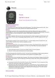
XC-Trainer Manual as pdf-file - Aircotec
XC-Trainer Manual as pdf-file - Aircotec
XC-Trainer Manual as pdf-file - Aircotec

Create successful ePaper yourself
Turn your PDF publications into a flip-book with our unique Google optimized e-Paper software.
2. <strong>XC</strong>-<strong>Trainer</strong> Firmware<br />
<strong>Manual</strong> V2.3-2_2005_V1<br />
2.1 Firmware Version V2.2-2005<br />
Downloads and Firmware may be found at www.aircotec.ch<br />
2.2 Flight Recorder<br />
The integrated flight recorder saves position, altitude, climb/sinkrate,<br />
SOG, TAS (with speed sensor), heading and temperature every<br />
second for up to 18 hours<br />
2.3 Waypoints and routes<br />
224 waypoints sorted in 14 lists with 16 waypoints each.<br />
10 routes each with up to 16 turnpoints, selected from the 224<br />
waypoints<br />
2.4 Available data in the display<br />
2.4.1 Permanent displays<br />
Speed SOG and TAS (TAS with sensor attached), altitude,<br />
climb/sinkrate and heading. Relationship between right/left thermalling.<br />
Windspeed and –direction<br />
When glide angle display is switched OFF in MENU/SETTINGS/<strong>XC</strong>-SETTINGS:<br />
Graphical speed distribution curve with head- and tailwind indication,<br />
distance to turnpoint, local time and elapsed time since launch<br />
When glide angle display is switched ON in MENU/SETTINGS/<strong>XC</strong>-SETTINGS:<br />
Final glide calculator, turnpoint name, turnpoint altitude (AMSL),<br />
current glide angle, ETA (Estimated Time of Arrival), calculated glide<br />
to reach next turnpoint.<br />
2.4.2 Additional information in the Map mode<br />
Current heading, distance and bearing to next waypoint. Map scale<br />
can be set from 2.5x2.5km to 120x120km.<br />
Waypoint cylinder is drawn on map, and a bar at the bottom of the<br />
display helps timing turnpoint efficiency for the l<strong>as</strong>t 125m<br />
2.4.3 Additional information in the Thermal mode<br />
Current heading, distance and bearing to next waypoint.<br />
Graphical climb-rate distribution, wind compensated. Scale is 1x1km<br />
or 2x2km.<br />
Page 12