
Create successful ePaper yourself
Turn your PDF publications into a flip-book with our unique Google optimized e-Paper software.
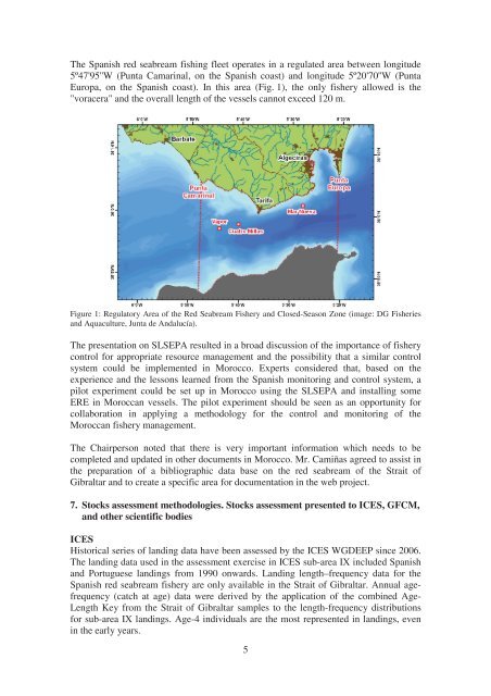
The Spanish red seabream fishing fleet operates in a regulated area between longitude<br />
5º47'95''W (Punta Camarinal, on <strong>the</strong> Spanish coast) and longitude 5º20'70''W (Punta<br />
Europa, on <strong>the</strong> Spanish coast). In this area (Fig. 1), <strong>the</strong> only fishery allowed is <strong>the</strong><br />
"voracera" and <strong>the</strong> overall length of <strong>the</strong> vessels cannot exceed 120 m.<br />
Figure 1: Regula<strong>to</strong>ry Area of <strong>the</strong> Red Seabream Fishery and Closed-Season Zone (image: DG Fisheries<br />
and Aquaculture, Junta de Andalucía).<br />
The presentation on SLSEPA resulted in a broad discussion of <strong>the</strong> importance of fishery<br />
control for appropriate resource management and <strong>the</strong> possibility that a similar control<br />
system could be implemented in Morocco. Experts considered that, based on <strong>the</strong><br />
experience and <strong>the</strong> lessons learned from <strong>the</strong> Spanish moni<strong>to</strong>ring and control system, a<br />
pilot experiment could be set up in Morocco using <strong>the</strong> SLSEPA and installing some<br />
ERE in Moroccan vessels. The pilot experiment should be seen as an opportunity for<br />
collaboration in applying a methodology for <strong>the</strong> control and moni<strong>to</strong>ring of <strong>the</strong><br />
Moroccan fishery management.<br />
The Chairperson noted that <strong>the</strong>re is very important information which needs <strong>to</strong> be<br />
completed and updated in o<strong>the</strong>r documents in Morocco. Mr. Camiñas agreed <strong>to</strong> assist in<br />
<strong>the</strong> preparation of a bibliographic data base on <strong>the</strong> red seabream of <strong>the</strong> Strait of<br />
Gibraltar and <strong>to</strong> create a specific area for documentation in <strong>the</strong> web project.<br />
7. S<strong>to</strong>cks assessment methodologies. S<strong>to</strong>cks assessment presented <strong>to</strong> ICES, GFCM,<br />
and o<strong>the</strong>r scientific bodies<br />
ICES<br />
His<strong>to</strong>rical series of landing data have been assessed by <strong>the</strong> ICES WGDEEP since 2006.<br />
The landing data used in <strong>the</strong> assessment exercise in ICES sub-area IX included Spanish<br />
and Portuguese landings from 1990 onwards. Landing length–frequency data for <strong>the</strong><br />
Spanish red seabream fishery are only available in <strong>the</strong> Strait of Gibraltar. Annual agefrequency<br />
(catch at age) data were derived by <strong>the</strong> application of <strong>the</strong> combined Age-<br />
Length Key from <strong>the</strong> Strait of Gibraltar samples <strong>to</strong> <strong>the</strong> length-frequency distributions<br />
for sub-area IX landings. Age-4 individuals are <strong>the</strong> most represented in landings, even<br />
in <strong>the</strong> early years.<br />
5